Showing 2089 items matching towers
-
 Greensborough Historical Society
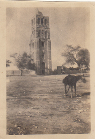
Photograph - Digital image, Charles Marshall et al, Crusader tower, Ramleh, 1918_
This photographs shows a tower in Ramleh, Egypt.Digital copy of black and white photograph. "Crusader tower, Ramleh"charles marshall, world war 1 -
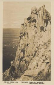
 Phillip Island and District Historical Society Inc.
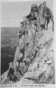
Photograph, The Watch Tower, Cape Woolamai
Part of a collection of 'Rose & Valentine' series of Post Cards. Copied by John Jansson 1984Black & White Postcard. Part of the rock formation on Cape Woolamai. Known as The Watch Tower.Rose Series P679. The Watch Tower, Cape Woolamai.local history, photography, photographs, postcards, cape woolamai, phillip island, black & white postcard copy, the watch tower, rock formation -
 Kew Historical Society Inc
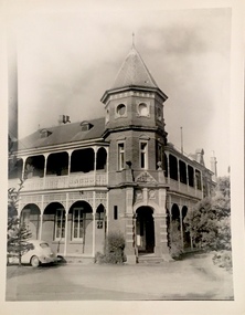
Photograph, 'Ramornie', Pakington Street, c.1960
This work forms part of the collection assembled by the historian Dorothy Rogers, that was donated to the Kew Historical Society by her son John Rogers in 2015. The manuscripts, photographs, maps, and documents were sourced by her from both family and local collections or produced as references for her print publications. Many were directly used by Rogers in writing ‘Lovely Old Homes of Kew’ (1961) and 'A History of Kew' (1973), or the numerous articles on local history that she produced for suburban newspapers. Most of the photographs in the collection include detailed annotations in her hand.The Rogers Collection provides a comprehensive insight into the working habits of a historian in the 1960s and 1970s. Together it forms the largest privately-donated collection within the archives of the Kew Historical Society.Small black and white photograph of the tower and verandas of Ramornie in Pakington Street, Kew.."Commenced 1890 by J.M. Campbell / Ramornie now The Towers / 18"historic houses -- kew (vic.), ramornie -- pakington street -- kew (vic.), the towers -- pakington street -- kew (vic), james maitland campbell -
 Kew Historical Society Inc
Photograph - 'Fernhurst', 13 Fernhurst Grove, 1978
George Wharton arrived in Melbourne in 1844. An architect and surveyor, he was appointed to lay out the 'Village of Kew' by N.A. Fenwick following the land sales of 1851. A protagonist for Kew's separation from the Boroondara District Road Board, he was elected chairman when Kew achieved municipal status in December 1860. His home, 'Fernhurst', was built in 1866 on eight acres in Studley Park, with a four-storey tower and pyramidal roof. The Italianate home was a prominent Kew landmark. It was demolished in 1979 and replaced by St Paul's College in 1980.Rare colour photograph of what was once a significant mansion in Kew.Original colour positive photograph (Kodak print) of 'Fernhurst' in 1978. Photographed by Stewart West in May 1978, one year before it was demolished, the photograph gives little idea of the large landholding once surrounding the house. Originally accessed from near the corner of Princess Street and Studley Park Road, its gardens had been subdivided in the 1900s and its footprint restricted to 13 Fernhurst Grove. Like many other grand houses, by the 1970s it had been converted into apartments. From the photograph, one can see that the house had retained many of its original features such as the distinctive tower and the wide bow-fronted verandah. The slates on the roof (apart from those on the tower) had been replaced by tiles and the cement render of the exterior painted white. Annotated reverse: "Front view of Fernhurst showing tower to advantage / 9"fernhurst, 13 fernhurst grove -- kew (vic.), george wharton, italianate architecture, vila maria society, st paul's school for the blind -
 Phillip Island and District Historical Society Inc.
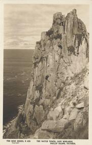
Photograph - Post Card, Early 20th Century
One of a collection of 6 postcards donated by T. H. HillSepia Postcard of The Watch Tower, Cape Woolamai, Phillip Island"The Rose Series, P. 679" "The Watch Tower, Cape Woolamai, Phillip Island, Victoria"the watch tower, the watch tower cliffs, coastline cape woolamai, cape woolamai cliffs, phillip island coastline, rock formations, t h hill -
 Phillip Island and District Historical Society Inc.
Photograph - Post Card, Early 1900's
One of a collection of 4 photographs donated by Y. Hancock.Sepia postcard of a rock formation at Cape Woolamai called The Watch Tower."The Rose Series P. 679" "The Watch Tower, Cape Woolamai, Phillip Island, Victoria"the watch tower, the watch tower cliffs, cape woolamai cliffs, the watch towes at cape woolamai, phillip island coastline, y hancock -
 Ringwood and District Historical Society
Photograph, Methodist Church, Station Street, Ringwood - viewed from clock tower in 1960, 1960
Methodist Church, Station Street, Ringwood, viewed from the clock tower at Warrandyte Road in 1960Written on back of photograph, "Methodist Church from clock tower - 1960". -
 Whitehorse Historical Society Inc.
Article, Developers wary of suburban high-rises, 2005
Article on the commercial non-viability of suburban high-rise apartments such as the approved Mitcham Twin Towers.Article on the commercial non-viability of suburban high-rise apartments such as the approved Mitcham Twin Towers. With artists impression of the towers.Article on the commercial non-viability of suburban high-rise apartments such as the approved Mitcham Twin Towers. high-rise buildings, melbourne 2030, mitcham -
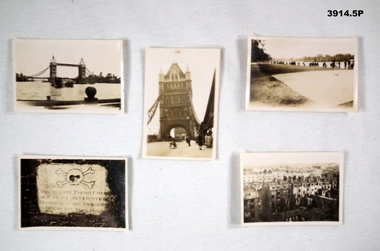 Bendigo Military Museum
Memorabilia - PHOTOGRAPHS, 5) 1942
Photos taken by Frederick Gardner DAVEY whilst in UK, c.1942 Item re Frederick Gardner DAVEY DFC No 410533 RAAF. Refer Reg No 3536P for his service details.Series of 5 black / white photos depicting scenes of London & Brighton. .1) Tower Bridge with River Thames in foreground. .2) One of the Tower Bridge towers. People & vehicles crossing the bridge. .3) People sitting on the edge of the Serpentine River, Hyde Park. .4) Plaque. .5) View of a row of terrace houses in Brighton.Handwritten in black ink of back of each: .1) London Bridge .2) Tower Bridge, London .3) Serpentine, Hyde Park, London .4) Plaque in Tower of London .5) Roof top view of Brighton. End. 1942photography, london, wartime -
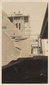 Phillip Island and District Historical Society Inc.
Photograph, 1927
This photo shows building of tower with scaffolding and the builders on the top.Building of St Pauls tower.local history, photography, photographs, slides, film, st pauls training school, schools, phillip island, sepia photograph, ken pound -
 Port of Echuca
Postcard, Early 20th Century
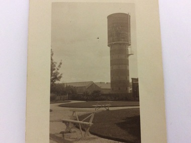
The water tower on the corner of Pakenham St and High Street Echuca, was designed by Sir John Monash, who was an innovator in the use of reinforced concrete. The tower cost £2,973 and was completed in 1915. It is 108 feet high and holds 150,000 gallons. it was originally connected to the steam powered pumping plant at Echuca East. John Monash was a war hero at Gallipoli in 1915 and also went on to be the Manager of the Victorian State Electricity Commission. Monash University was named after him.The water tower was a revolutionary design in 1915. It also brought tapped water to people's homes. Sir John Monash made a huge contribution to engineering and social concepts, which was why he was knighted. As well as these contributions to social development, he was also a war hero.Black and white postcard featuring the water tower in Packenham Street. The photograph was taken from Alton Reserve. The background shows a conglomeration of buildings and the foreground shows shaped lawns and park benches. The postcard has a thick border in a cream colour all around it.On the reverse is printed ; POST CARD. Write here for Inland Postage only. Tha Address to be written here. In pen is hand written the words View of Water Tower Pakenham St. Taken from Alton Reserve?echuca east pumping station, echuca water tower, monash, sir john, alton reserve, engineering, reinforced concrete -
 Emerald Museum & Nobelius Heritage Park
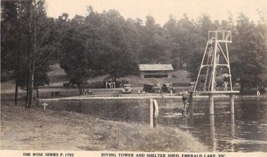
Photograph, Rose Series Postcard - Diving Tower and Shelter Shed, Emerald Lake. Victoria, circa 1940 - 50
Depicting early years of Emerald Lake Photograph of Emerald Park Lake showing diving tower circa 40'sFront: The Rose Series P. 1792 'Diving Tower and Shelter Shed, Emerald Lake, Vic. emerald park lake, rose series postcards -
Whitehorse Historical Society Inc.
Article, It's over at last for tower, 2015
The Telstra communication tower on Canterbury Road, Surrey Hills.The Telstra communication tower on Canterbury Road, Surrey Hills is to be removed and replaced with a monopole structure following community outrage at proposed Heritage protection for the 45 metre tower.The Telstra communication tower on Canterbury Road, Surrey Hills. canterbury road, surrey hills, telstra -
 Stawell Historical Society Inc
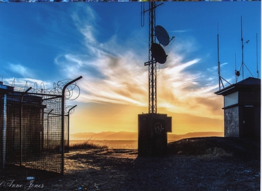
Photograph, Big Hill Sunset looking South West -- Coloured
Sunset from Big Hill looking Southwest. Fire Tower on right. Fire watch tower on right of photo. Communication Tower in the center. Stawell gold mine ventilation shaft on the left with barb wire around the fence. Spectacular sky in the background.Colored photo of sunset looking southwest on Big Hill. Fire watch tower on right of photo. Communication Tower in the center. Stawell gold mine ventilation shaft on the left. Carol Anne Jonesstawell -
 Emerald Museum & Nobelius Heritage Park
Photograph/postcard, Rose Series Postcard - Diving Tower and Shelter Shed, Emerald Lake. Victoria, late 1940's
Photograph of Emerald Park Lake showing diving tower circa late 40'sFront: The Rose Series P. 1792 'Diving Tower and Shelter Shed, Emerald Lake, Vic. emerald park lake, rose series postcards -
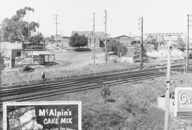
 Wodonga & District Historical Society Inc
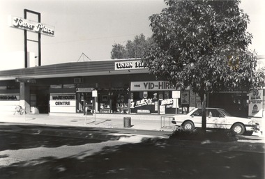
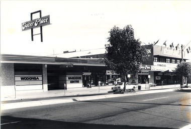
Photograph - Codling Collection 01 - High Street West - Tower Place, 1970s
Miss Olive Codling was a Foundation Member and a Life Member of the Wodonga Historical Society. Many of her prize-winning photos are held in the Society Collection. She also held a range of roles and committee positions in a wide range of Wodonga community organisations. These included the Horticultural Society, the Wodonga Arts Council, the Wodonga Camera Club and the Wodonga Lapidary Club. This photo collection is significant as it documents how the businesses and buildings in Wodonga have evolved and contributed to community throughout the 20th century.High Street West, Tower Place on the left. Businesses shown include Wodonga Warehouse Centre, Rob Lacey Photography, Vid Hire and East West Airlines . Tower Place was built by Arthur Dunstan, owner of A. Dunstan & Sons Hardware and timber mills. On sign above building "Tower Place", on front of building on left "WODONGA WAREHOUSE CENTRE"wodonga businesses, high st wodonga, wodonga warehouse centre, tower place -
Federation University Historical Collection
Model, Petronas Tower, Kuala Lumper, c2005
Malaysia's Petronas Towers are considered to be one of the tallest buildings in the world. Model of the Petronas Towers in a glass case. Plaque "Signing ceremony memorandum of agreement between University of Ballarat" and Unity College International Monday 8th August 2005petronas towers, kuala lumper, model, malaysia, unity college international, university of ballarat, agreement -
 Wodonga & District Historical Society Inc
Drawing - Water Tower, Wodonga, 2020
THE WATER TOWER is a major landmark of High Street, Wodonga. It began operation from 1924 until it ceased operation in 1952. It stood unused for a decade until the lower section was modified and put to use as “ The Tower’s Cobbler’s Inn” in 1962. In 1972 Wodonga City Council proposed to demolish the Tower. Their suggestion received an unfavorable response from the city’s citizens, so the Tower still stands today.Donated by Dr. Imalka WettesingeRepresentation of the Water Tower in High Street, Wodonga in white framewodonga water tower, scenic features wodonga -
 Ballarat Heritage Services
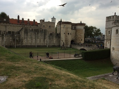
Digital photograph, Dorothy Wickham, Tower of London, 2016
The Tower of London, officially Her Majesty's Royal Palace and Fortress of the Tower of London, is a historic castle located on the north bank of the River Thames in central London. It lies within the London Borough of Tower Hamlets, separated from the eastern edge of the square mile of the City of London by the open space known as Tower Hill. It was founded towards the end of 1066 as part of the Norman Conquest of England. The White Tower, which gives the entire castle its name, was built by William the Conqueror in 1078, and was a resented symbol of oppression, inflicted upon London by the new ruling elite. The castle was used as a prison from 1100 (Ranulf Flambard) until 1952 (Kray twins),[3] although that was not its primary purpose. A grand palace early in its history, it served as a royal residence. As a whole, the Tower is a complex of several buildings set within two concentric rings of defensive walls and a moat. There were several phases of expansion, mainly under Kings Richard the Lionheart, Henry III, and Edward I in the 12th and 13th centuries. The general layout established by the late 13th century remains despite later activity on the site. The Tower of London has played a prominent role in English history. It was besieged several times, and controlling it has been important to controlling the country. The Tower has served variously as an armoury, a treasury, a menagerie, the home of the Royal Mint, a public record office, and the home of the Crown Jewels of England. From the early 14th century until the reign of Charles II, a procession would be led from the Tower to Westminster Abbey on the coronation of a monarch. In the absence of the monarch, the Constable of the Tower is in charge of the castle. This was a powerful and trusted position in the medieval period. In the late 15th century the castle was the prison of the Princes in the Tower. Under the Tudors, the Tower became used less as a royal residence, and despite attempts to refortify and repair the castle its defences lagged behind developments to deal with artillery. The peak period of the castle's use as a prison was the 16th and 17th centuries, when many figures who had fallen into disgrace, such as Elizabeth I before she became queen, Sir Walter Raleigh, and Elizabeth Throckmorton were held within its walls. This use has led to the phrase "sent to the Tower". Despite its enduring reputation as a place of torture and death, popularised by 16th-century religious propagandists and 19th-century writers, only seven people were executed within the Tower before the World Wars of the 20th century. Executions were more commonly held on the notorious Tower Hill to the north of the castle, with 112 occurring there over a 400-year period. In the latter half of the 19th century, institutions such as the Royal Mint moved out of the castle to other locations, leaving many buildings empty. Anthony Salvin and John Taylor took the opportunity to restore the Tower to what was felt to be its medieval appearance, clearing out many of the vacant post-medieval structures. In the First and Second World Wars, the Tower was again used as a prison, and witnessed the executions of 12 men for espionage. After the Second World War, damage caused during the Blitz was repaired, and the castle reopened to the public. Today the Tower of London is one of the country's most popular tourist attractions. Under the ceremonial charge of the Constable of the Tower, it is cared for by the charity Historic Royal Palaces and is protected as a World Heritage Site.(Wikipedia) A World Heritage Site is a landmark which has been officially recognized by the United Nations, specifically by UNESCO. Sites are selected on the basis of having cultural, historical, scientific or some other form of significance, and they are legally protected by international treaties. UNESCO regards these sites as being important to the collective interests of humanity. More specifically, a World Heritage Site is an already classified landmark on the earth, which by way of being unique in some respect as a geographically and historically identifiable piece is of special cultural or physical significance (such as either due to hosting an ancient ruins or some historical structure, building, city, complex, desert, forest, island, lake, monument, or mountain) and symbolizes a remarkable footprint of extreme human endeavour often coupled with some act of indisputable accomplishment of humanity which then serves as a surviving evidence of its intellectual existence on the planet. And with an ignoble intent of its practical conservation for posterity, but which otherwise could be subject to inherent risk of endangerment from human or animal trespassing, owing to unmonitored/uncontrolled/unrestricted nature of access or threat by natural or accelerated extinction owing to local administrative negligence, hence it would have been listed and demarcated by the United Nations Educational, Scientific and Cultural Organization (UNESCO) to have been identified or recognised and officially christened and internationally elevated through multilateral declaration by UNESCO as a universally protected zone. [1] The list is maintained by the international World Heritage Programme administered by the UNESCO World Heritage Committee, composed of 21 UNESCO member states which are elected by the General Assembly. (Wikipedia)The Tower of London is a UNESCO world heritage site.tower of london -
 Darebin Parklands Association
Ranger Peter Wiltshire throwing water plants into the wetlands, Darebin Parklands Association, 1993
This photograph is one of a series of 76 in folder P001 - taken at the opening of the observation tower.Colour photograph. Opening of the observation tower. -
 Victorian Interpretive Projects Inc.
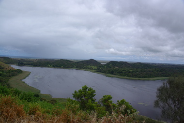
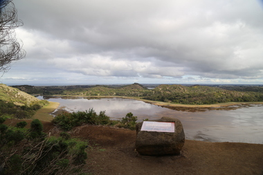
Photograph - Colour, Clare Gervasoni, Tower Hill, Victoria, 2013
The Tower Hill Reserve is located inside a dormant volcano, and features a lake and wetlands. It became Victoria's first national park in 1892, but by the 1930s the early settlers had cleared much of the land for grazing, cropping and quarrying. In the 1960s the bare hills and islands were revegetated based in species identified from Eugene von Guerard's painting of Tower Hill. Tower Hill was formed around 30,000 years ago in a violent volcanic eruption. The initial eruption created the outer rim of the volcano, and later smaller eruptions formed the internal hills that are evident today. The layers of volcanic ash layers include artefacts relating to indigenous communites.A series of colour digital photographs showing Tower Hill, near Port Fairy, Victoria. Tower Hill is an extinct volcano.tower hill, volcano, extinct -
 Ballarat Heritage Services
Digital photographs, L.J. Gervasoni, Lake at Tower Hill, c2015
Tower Hill is an extinct volcano in the Western District of Victoria.Colour photographs of Tower Hill and the crater lake.tower hill, volcano, natural heritage, koroit, lake, landscape -
 Wodonga & District Historical Society Inc
Photograph - Codling Collection 01 - High Street West, Tower Place, 1970s
Miss Olive Codling was a Foundation Member and a Life Member of the Wodonga Historical Society. Many of her prize-winning photos are held in the Society Collection. She also held a range of roles and committee positions in a wide range of Wodonga community organisations. These included the Horticultural Society, the Wodonga Arts Council, the Wodonga Camera Club and the Wodonga Lapidary Club. This photo collection is significant as it documents how the businesses and buildings in Wodonga have evolved and contributed to community throughout the 20th century.High Street West, Tower Place on the left and Highpoint on the right. Tower Place was built by Arthur Dunstan, owner of A. Dunstan & Sons Hardware and timber mills. Businesses shown include Wodonga Warehouse Centre, Highpoint Furniture, Rob Lacey Photography, Vid Hire, East West Airlines and Retravision.On sign above building "Tower Place", on front of building on left "WODONGA WAREHOUSE CENTRE"wodonga businesses, high st wodonga, tower place, highpoint wodonga -
 Ballarat Heritage Services
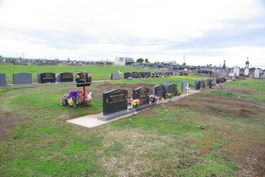
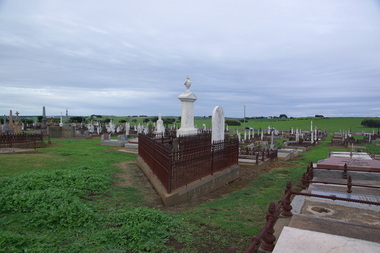
Photograph - Photograph - Colour, Clare Gervasoni, Tower Hill Cemetery, 2009, 26/07/2009
The Tower Hill Cemetery is located near Koroit on the north side of the Princes Highway The, between Port Fairy and Warrnambool. The first burial at Tower Hill Cemetery took place in 1856. Over 150 years there has been over 8,000 burials. Around 45 percent of the burials are in unmarked graves.Colour photograph of a headstone in the Tower Hill Cemetery.tower hill cemetery, william rutledge, eliza rutledge -
 Ballarat Heritage Services
Photograph - Photograph - Colour, Clare Gervasoni, Tower Hill Cemetery, 2009, 26/07/2009
The Tower Hill Cemetery is located near Koroit on the north side of the Princes Highway The, between Port Fairy and Warrnambool. The first burial at Tower Hill Cemetery took place in 1856. Over 150 years there has been over 8,000 burials. Around 45 percent of the burials are in unmarked graves.Colour photograph of a headstone in the Tower Hill Cemetery.tower hill cemetery -
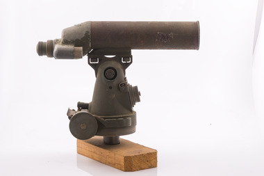 Forests Commission Retired Personnel Association (FCRPA)
Telescope used in FCV fire towers - ex military, c 1940s
Victoria once had well over one hundred fire lookouts and firetowers. Fire lookouts, or observation posts, were often just a clearing on a hill or a vantage point, whereas firetowers were definite structures. Many were established by the Forests Commission Victoria (FCV) in the 1920s, but the network was expanded rapidly in response to recommendations of the Stretton Royal Commission after the 1939 Black Friday bushfires. When a fire or smoke was spotted from the tower a bearing was taken with the alidade and radioed or telephoned into the district office. It was then cross referenced with bearings from other towers on a large wall map to give a "fix" on the fire location Alidades and telescopes were used in the post war period but were replaced with a much simpler map table and reference string suspended from the centre of the tower cabin.Uncommon usageTelescope used in fire towers Ex military Kern Company NY Argus made in USA Adjustment lens, dials and focus ring Small spirit levelbushfire -
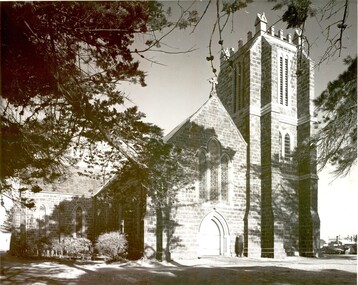 Port Fairy Historical Society Museum and Archives
Photograph
St Johns Church of England with the towerBlack and white photograph of St Johns Church of England with towerchurch, sunday-school, building, church of england, anglican, tower -
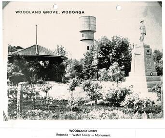 Wodonga & District Historical Society Inc
Photograph - Codling Collection 01 - Woodland Grove, Wodonga
Miss Olive Codling was a Foundation Member and a Life Member of the Wodonga Historical Society. Many of her prize-winning photos are held in the Society Collection. She also held a range of roles and committee positions in a wide range of Wodonga community organisations. These included the Horticultural Society, the Wodonga Arts Council, the Wodonga Camera Club and the Wodonga Lapidary Club. Woodland Grove is located in the triangular reserve at the corner of High and Hovell Streets, Wodonga. ‘Woodland Grove". It was named in honour of John Woodland at the same time as the opening of the band rotunda in September 1920. John Woodland, Wodonga Shire’s first president, was born in Kent, England, in 1829 and came to Sydney with his parents in 1839. He arrived in the Wodonga district about 1853, where he created a successful carrier's business. He first lived on the Old Barnawartha Estate and a few years later purchased land at Green Hills, Wodonga West, where he farmed and also ran a hotel. The hotel licence was relinquished to give attention to duties as secretary and clerk of works to Wodonga Shire, which was then the Wodonga Riding of the Shire of Yackandandah. He was a main agitator for the separation of Wodonga district from Yackandandah Shire. This was successful in 1876, and he became the first president of Wodonga Shire. He held this post for two years, then taking on the role of shire secretary in 1878 until 1913. He concurrently undertook the role of clerk of works (engineer) from 1896 to 1907. As clerk of works he prepared the plans and specifications for, and supervised the construction of the big bridges on the Albury road and at Bonegilla and other important works. In his mid 70s, he proffered his resignation on a number of occasions but it was not accepted. Despite physical weakness and impaired vision, John continued his duties to the end, with the help of his daughter Rose Murphy. Rose became shire secretary for 20 years after her father’s death in 1913.This photo collection is significant as it documents the naming of a public area in Wodonga to honour an original and long-serving member of the Wodonga Shire Council.A black and white photo of Woodland Grove in High Street, Wodonga. It includes the rotunda, the water tower and the soldier's memorial. There is a post and wire fence in the foreground as well as several trees and rose bushes. Beneath the photo: "WOODLAND GROVE / Rotunda - Water Tower - Memorial"high st wodonga, woodland grove, john woodland -
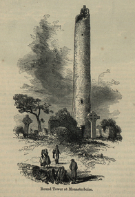 Ballarat and District Irish Association
Image, Round Tower at Monasterboice, c1864
The historic ruins of Monasterboice are of an early Christian settlement north of Drogheda in County Louth, Ireland. It was founded in the late 5th century by Saint Buithe who died around 521, and was an important centre of religion and learning until the founding of nearby Mellifont Abbey in 1142. The site houses two churches built in the 14th century or later and an earlier round tower, but it is most famous for its 10th century high crosses. The round tower is about 35-metres tall, and is in very good condition, although it is not possible to go inside. The passage of time has laid down layers of earth so now the doorway is almost at ground level. The monastery was burned in 1097. The 5.5-metre Muiredach's High Cross is regarded as the finest high cross in the whole of Ireland. It is named after an abbot, Muiredach mac Domhnaill, who died in 923 and features biblical carvings of both the Old and New Testaments of the Bible. The North and West crosses are also fine examples of this kind of structure, but these have suffered much more from the effects of the weather. (http://en.wikipedia.org/wiki/Monasterboice)Image of a round tower in a graveyard. It is the Round Tower at Monasterboiceballarat irish, monsasterboice