Showing 215 items matching "township and bridges"
-
 Lakes Entrance Historical Society
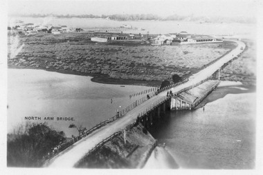
Postcard - North Arm bridge Lakes Entrance Victoria c1950
... Bridges...Black and white postcard of the North Arm bridge, lakes and western section of township, sand hummocks in distance. ...North Arm Bridge Lakes Entrance. (on back holidays 1951)Also 1x tinted photographic postcard identical scene 01162-2 good condition Bridges Township Black and white postcard of the North Arm bridge, lakes and western section of township, sand hummocks in distance. ...North Arm Bridge Lakes Entrance. (on back holidays 1951)Also 1x tinted photographic postcard identical scene 01162-2 good conditionBlack and white postcard of the North Arm bridge, lakes and western section of township, sand hummocks in distance. Lakes Entrance Victoriabridges, township -
 Lakes Entrance Historical Society
Postcard - View of Bruthen, W S Vogt Bairnsdale, Tambo River Bruthen, 1918 c
... Township...Black and white postcard showing township, roads and rail, bridges and barked trees with cultivated land beside Tambo River Bruthen Victoria...Lakes Entrance Historical Society 4 Marine Parade Lakes Entrance gippsland Township Bridges Roads and Streets Tambo River at Bruthen Black and white postcard showing township, roads and rail, bridges and barked trees with cultivated land beside Tambo River Bruthen Victoria Tambo River Bruthen Postcard View of Bruthen W S Vogt Bairnsdale ...Black and white postcard showing township, roads and rail, bridges and barked trees with cultivated land beside Tambo River Bruthen VictoriaTambo River at Bruthentownship, bridges, roads and streets -
 Lakes Entrance Historical Society
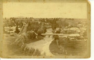
Postcard - North Arm showing the western end of township, Lakes Entrance c1940, Bulmer, H D
... Township...Black and white photographic of bridge over North Arm showing the western end of township, sand hummock viewed in distance, Lakes Entrance Victoria...|The after paired photograph number is 01156.1 Also one 12 x 16 framed photograph used in room display. Township Bridges Room display Black and white photographic of bridge over North Arm showing the western end of township, sand hummock viewed in distance, Lakes Entrance Victoria Postcard North Arm showing the western end of township, Lakes Entrance c1940 Bulmer, H D ...One Black and White Photograph 6.5 x 11|Two Postcard 8.5 x 14|Two Small format postcard 6 x 9|This is the before paired photograph used in the 150 year, Lakes Entrance 1858-2008 display.|The after paired photograph number is 01156.1 Also one 12 x 16 framed photograph used in room display.Black and white photographic of bridge over North Arm showing the western end of township, sand hummock viewed in distance, Lakes Entrance Victoriatownship, bridges, room display -
 Lakes Entrance Historical Society
Postcard - First concrete bridge over North Arm Lakes Entrance Victoria, H D Bulmer, 1920 c
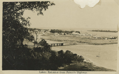
... ...Bridges...Black and white postcard of township showing first concrete bridge over North Arm swamp land behind buildings on Esplanade low sand dunes on outer barrier Lakes Entrance Victoria...Lakes Entrance Historical Society 4 Marine Parade Lakes Entrance gippsland First concrete bridge over North Arm swamp land behind buildings on Esplanade low sand dunes on outer barrier Lakes Entrance Victoria Islands Roads and Streets Bridges Township Lakes Entrance from Princes Highway Black and white postcard of township showing first concrete bridge over North Arm swamp land behind buildings on Esplanade low sand dunes on outer barrier Lakes Entrance Victoria Postcard First concrete bridge over North Arm Lakes Entrance Victoria H D Bulmer ...First concrete bridge over North Arm swamp land behind buildings on Esplanade low sand dunes on outer barrier Lakes Entrance VictoriaBlack and white postcard of township showing first concrete bridge over North Arm swamp land behind buildings on Esplanade low sand dunes on outer barrier Lakes Entrance VictoriaLakes Entrance from Princes Highwayislands, roads and streets, bridges, township -
 Lakes Entrance Historical Society
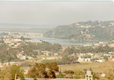
Photograph - Views of Lakes Entrance Victoria c1990, Tambo Shire
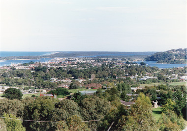
... Bridges...Color photograph of the township, showing a distant view of the Ninety Mile Beach, the Gippsland Lakes and islands, Kalimna Heights, the bridge over the North Arm, Cunninghame Arm, and a broad view of the town and tree lined streets. ...Also second copy photographic enlargements of significant sites in the Tambo Shire Bridges Topography Township Waterways Color photograph of the township, showing a distant view of the Ninety Mile Beach, the Gippsland Lakes and islands, Kalimna Heights, the bridge over the North Arm, Cunninghame Arm, and a broad view of the town and tree lined streets. ...Also second copy photographic enlargements of significant sites in the Tambo ShireColor photograph of the township, showing a distant view of the Ninety Mile Beach, the Gippsland Lakes and islands, Kalimna Heights, the bridge over the North Arm, Cunninghame Arm, and a broad view of the town and tree lined streets. Lakes Entrance Victoriabridges, topography, township, waterways -
 Lakes Entrance Historical Society
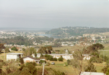
Photograph - Views of Lakes Entrance Victoria c1985, Fish, Marie
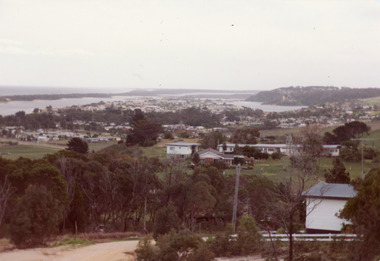
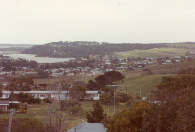
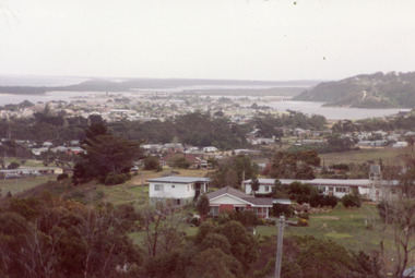
... ... Township...Colour photograph of part of township showing Jemmys Point, Mount Barkly, Kalimna Heights, North Arm & old North Arm bridge, looking beyond to Rigby Island. ...Topography Township Waterways Bridges Colour photograph of part of township showing Jemmys Point, Mount Barkly, Kalimna Heights, North Arm & old North Arm bridge, looking beyond to Rigby Island. ...Colour photograph of part of township showing Jemmys Point, Mount Barkly, Kalimna Heights, North Arm & old North Arm bridge, looking beyond to Rigby Island. Photo taken from near Telecom Tower on Merrangbaur Hill. Lakes Entrance Victoriatopography, township, waterways, bridges -
 Lakes Entrance Historical Society
Photograph - View of North Arm Lakes Entrance c1985, Fish, Marie
... Bridges...Colour photograph, image of part of township, showing Jemmy's Point, Mount Barkly, North Arm and old North Arm bridge, football ground mid picture. ...Bridges Waterways Township Colour photograph, image of part of township, showing Jemmy's Point, Mount Barkly, North Arm and old North Arm bridge, football ground mid picture. ...Colour photograph, image of part of township, showing Jemmy's Point, Mount Barkly, North Arm and old North Arm bridge, football ground mid picture. View towards Rigby Island, Hopetoun Channel and dunes. Photo taken using telephoto lens from near Telecom Tower on Merrangbaur Hill. Lakes Entrance Victoria bridges, waterways, township -
 Lakes Entrance Historical Society
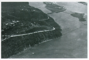
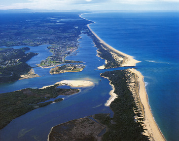
Photograph - Aerial view of Lakes Entrance and Kalimna c1940, Bulmer H D
... ...Bridges...Black and white photograph of aerial view of Kalimna Heights, showing scattered buildings, Princes Highway around side of cliff, western end of township, North Arm bridge, footbridge to Bullock Island and rock groynes. ...Waterways Roads and Streets Bridges Township Black and white photograph of aerial view of Kalimna Heights, showing scattered buildings, Princes Highway around side of cliff, western end of township, North Arm bridge, footbridge to Bullock Island and rock groynes. ...Black and white photograph of aerial view of Kalimna Heights, showing scattered buildings, Princes Highway around side of cliff, western end of township, North Arm bridge, footbridge to Bullock Island and rock groynes. Track to lookout and signal beacon visible. Lakes Entrance Victoria waterways, roads and streets, bridges, township -
 Lakes Entrance Historical Society
Photograph - Views of Lakes Entrance Victoria c1985, Fish, Marie
... ... Township...Colour photograph of township, showing buildings, Jemmy's Point, Mount Barkly, Kalimna Heights, North Arm with old North Arm bridge and Rigby Island beyond. ...Topography Township Waterways Bridges Colour photograph of township, showing buildings, Jemmy's Point, Mount Barkly, Kalimna Heights, North Arm with old North Arm bridge and Rigby Island beyond. ...Colour photograph of township, showing buildings, Jemmy's Point, Mount Barkly, Kalimna Heights, North Arm with old North Arm bridge and Rigby Island beyond. Sea Vista flats in foreground. Photo taken from near Telecom Tower on Merrangbaur Hill. Lakes Entrance Victoriatopography, township, waterways, bridges -
 Lakes Entrance Historical Society
Photograph - Lakes Entrance, c1985
... Bridges...Colour photograph showing aerial view of township and the Ninety Mile Beach. Pecks factory on Bullock Island, Old North Arm bridge, bitumen for carpark for future. ...Lakes Entrance Historical Society 4 Marine Parade Lakes Entrance gippsland Photo was cut from Tourist brochure Bridges Coast Waterways Topography Township Colour photograph showing aerial view of township and the Ninety Mile Beach. ...Photo was cut from Tourist brochureColour photograph showing aerial view of township and the Ninety Mile Beach. Pecks factory on Bullock Island, Old North Arm bridge, bitumen for carpark for future. Fishermen's Club near North Arm Bridge. Photo shows east end of Rigby Island and Snake Island. Glimpse of Red Bluff, Lake Bunga and Lake Tyers in far east. Lakes Entrance Victoriabridges, coast, waterways, topography, township -
 Lakes Entrance Historical Society
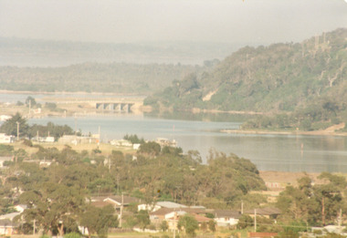
Photograph - Views of Lakes Entrance Victoria c1985
... Bridges...Colour photograph of township of Lakes Entrance showing North Arm, North Arm Bridge, Jemmy's Point, Mount Barkly, Kalimna Heights, Cunningham Arm and sand dunes on left. ...Bridges Waterways Islands Township Colour photograph of township of Lakes Entrance showing North Arm, North Arm Bridge, Jemmy's Point, Mount Barkly, Kalimna Heights, Cunningham Arm and sand dunes on left. ...Colour photograph of township of Lakes Entrance showing North Arm, North Arm Bridge, Jemmy's Point, Mount Barkly, Kalimna Heights, Cunningham Arm and sand dunes on left. Looking west to Bullock Island and Rigby Island. Photo taken from near Telecom Tower on Merrangbaur Hill. Lakes Entrance Victoria bridges, waterways, islands, township -
 Lakes Entrance Historical Society
Photograph - Views of Lakes Entrance Victoria c1985, Fish, Marie, 1985c
... Bridges...Colour photograph of township showing, North Arm and North Arm Bridge, Jemmys Point, Mount Barkly, Kalimna Heights on right, Cunninghame Arm and sand dunes on left. ...Bridges Waterways Township Colour photograph of township showing, North Arm and North Arm Bridge, Jemmys Point, Mount Barkly, Kalimna Heights on right, Cunninghame Arm and sand dunes on left. ...Colour photograph of township showing, North Arm and North Arm Bridge, Jemmys Point, Mount Barkly, Kalimna Heights on right, Cunninghame Arm and sand dunes on left. Looking towards Bullock Island and Rigby Island and Hopetoun Channel in centre background. Sea Vista flats in foreground. Photo take from near Telecom Tower on Merrangbaur Hill circa 1985. Lakes Entrance Victoria bridges, waterways, township -
 Lakes Entrance Historical Society
Photograph - Views of Lakes Entrance Victoria c1985, Fish, Marie
... Bridges...Colour photograph of township showing, North Arm and North Arm Bridge, Jemmy's Point, Mount Barkly, Kalimna Heights on right, Cunninghame Arm and sand dunes on left. ...\ Bridges Waterways Township Colour photograph of township showing, North Arm and North Arm Bridge, Jemmy's Point, Mount Barkly, Kalimna Heights on right, Cunninghame Arm and sand dunes on left. ...\Colour photograph of township showing, North Arm and North Arm Bridge, Jemmy's Point, Mount Barkly, Kalimna Heights on right, Cunninghame Arm and sand dunes on left. Looking towards Bullock Island and Rigby Island and Hopetoun Channel in centre background. Sea Vista flats in foreground. Photo take from near Telecom Tower on Merrangbaur Hill circa 1985. Lakes Entrance Victoria bridges, waterways, township -
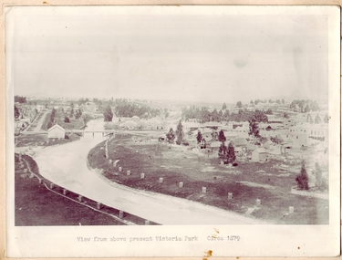 Clunes Museum
Photograph, CIRCA 1879
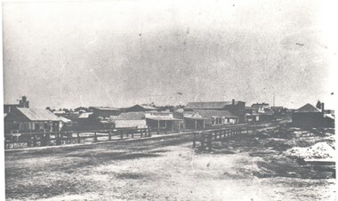
... PHOTOGRAPH OF CLUNES TOWNSHIP, SHOWING THE TWO BRIDGES ACROSS THE CREEK....PHOTOGRAPH OF CLUNES TOWNSHIP, SHOWING THE TWO BRIDGES ACROSS THE CREEK. ...PHOTOGRAPH OF CLUNES TOWNSHIP, SHOWING THE TWO BRIDGES ACROSS THE CREEK.VIEW FROM ABOVE PRESENT VICTORIA PARK.local history, photography, photographs, bridges - buildings and landscape of clunes -
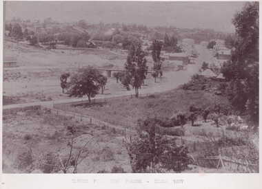 Clunes Museum
Photograph
... TOWNSHIP VIEW OF CLUNES, FROM LOWER FRASER STREET, TWO BRIDGES IN PICTURE....CIRCA 1897 TOWNSHIP VIEW OF CLUNES, FROM LOWER FRASER STREET, TWO BRIDGES IN PICTURE. ...PART OF CLUNES TOWNSHIP FROM CAMP PARADE.TOWNSHIP VIEW OF CLUNES, FROM LOWER FRASER STREET, TWO BRIDGES IN PICTURE.CLUNES FROM CAMP PARADE. CIRCA 1897local history, photography, photographs, clunes township -
Glenelg Shire Council Cultural Collection
Postcard - Postcard - Suspension bridge Casterton, 1900-1930
... Postcard, black and white,, showing the suspension bridge at Casterton, view across river towards township...Sythaleigh, Henty St Casterton' Postcard, black and white,, showing the suspension bridge at Casterton, view across river towards township Postcard Postcard - Suspension bridge Casterton ...SOURCED FROM CASTERTON TOWN HALL (FORMER SHIRE OF GLENELG) Sourced from Casterton Town Hall (Former Shire of Glenelg)Postcard, black and white,, showing the suspension bridge at Casterton, view across river towards townshipFront: 'SUSPN BRIDGE CASTERTON' Back: Handwritten correspondence, addressed to 'Miss M. Sythaleigh, Henty St Casterton' -
 Clunes Museum
Photograph
... VIEW OF SUSPENSION BRIDGE WITH TOWNSHIP IN THE DISTANCE INCLUDING ST THOMAS AQUINAS AND ST PAUL'S CHURCHES...Clunes Museum 36 Fraser Street enter building through Collins Place Clunes goldfields SUSPENSION BRIDGE LOCAL HISTORY VIEW OF SUSPENSION BRIDGE WITH TOWNSHIP IN THE DISTANCE INCLUDING ST THOMAS AQUINAS AND ST PAUL'S CHURCHES Photograph PHOTOGRAPH ...VIEW OF SUSPENSION BRIDGE WITH TOWNSHIP IN THE DISTANCE INCLUDING ST THOMAS AQUINAS AND ST PAUL'S CHURCHESsuspension bridge, local history -
 Hume City Civic Collection
Photograph, Early 1970s
... A black and white photograph of the Deep Creek and three arched bluestone bridge in the Bulla Township with the Kaolin Quarry in the background. ...The three arched bluestone bridge r3placed a ford crossing across Deep Creek, which along with Jacksons Creek flows into the Maribyrnong River. deep creek bridges kaolin quarries quarries george evans collection A black and white photograph of the Deep Creek and three arched bluestone bridge in the Bulla Township with the Kaolin Quarry in the background. ...The Kaolin Quarry at Bulla supplied Kaolin to the Northcote and Brunswick Pottery Works until it ceased operation at that site in the 1950s. The three arched bluestone bridge r3placed a ford crossing across Deep Creek, which along with Jacksons Creek flows into the Maribyrnong River.A black and white photograph of the Deep Creek and three arched bluestone bridge in the Bulla Township with the Kaolin Quarry in the background. One truck is crossing the bridge with a tanker approaching the bridge at the bottom of the Bulla Hill.deep creek, bridges, kaolin quarries, quarries, george evans collection -
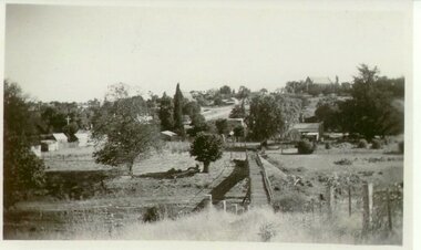
 Bendigo Historical Society Inc.
Photograph - HARRY BIGGS COLLECTION: LONG GULLY TOWNSHIP
... Harry Biggs Collection. 1 black & white photo of Long Gully township looking from Eaglehawk towards Bendigo near the bridge. ...On 1 shop can be seen P Pentreath. A wooden bridge can be seen over the creek. Long Gully Township looking from Eaglehawk to Bendigo near bridge (written on the back). ...Photograph. Harry Biggs Collection. 1 black & white photo of Long Gully township looking from Eaglehawk towards Bendigo near the bridge. On 1 shop can be seen P Pentreath. A wooden bridge can be seen over the creek. Long Gully Township looking from Eaglehawk to Bendigo near bridge (written on the back).photograph, streetscape, long gully, harry biggs collection, long gully township -
Glenelg Shire Council Cultural Collection
Negative - Negative - Glenelg River, Victoria, c. 1934
... View along Glenelg river at Nelson, Victoria. Township on right, bridge centre of the photo....View along Glenelg river at Nelson, Victoria. Township on right, bridge centre of the photo. ...Part of a collection of photographs taken by Zillah Maschmedt in 1934. Zillah was a teacher from South Australia.Transparency for black and white photo. View along Glenelg river at Nelson, Victoria. Township on right, bridge centre of the photo.zillah maschmedt, photography, glenelg river -
 Clunes Museum
Photograph
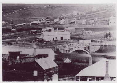
... BLACK & WHITE PHOTOGRAPH GENERAL VIEW CLUNES TOWNSHIP WITH GOVERNMENT BRIDGE IN CENTRE OF PHOTOGRAPH, EBERHARD SOFT DRINK FACTORY...Clunes Museum 36 Fraser Street enter building through Collins Place Clunes goldfields photographs township GOVERMENT BRIDGE BLACK & WHITE PHOTOGRAPH GENERAL VIEW CLUNES TOWNSHIP WITH GOVERNMENT BRIDGE IN CENTRE OF PHOTOGRAPH, EBERHARD SOFT DRINK FACTORY Photograph PHOTOGRAPH ...BLACK & WHITE PHOTOGRAPH GENERAL VIEW CLUNES TOWNSHIP WITH GOVERNMENT BRIDGE IN CENTRE OF PHOTOGRAPH, EBERHARD SOFT DRINK FACTORYphotographs, township, goverment bridge -
Glenelg Shire Council Cultural Collection
Negative - Negative -Glenelg River Nelson, Victoria, Miss Zillah Maschmedt, photographer, c. 1936
... Image shows view across Glenelg River to Nelson township, bridge in foreground Nelson Victoria....Image shows view across Glenelg River to Nelson township, bridge in foreground Nelson Victoria. ...Negative for a black and white photograph. Image shows view across Glenelg River to Nelson township, bridge in foreground Nelson Victoria. -
 Hume City Civic Collection
Photograph, Early 1970s
... A black and white panoramic view of the eastern approach to Sunbury and the Sunbury township before the road was widened and straightened and the new bridge was built. ...The area on the LHS of the photograph including the two arched stone bridge has been incorporated into a public picnic area. macedon street macedon street road bridge jacksons creek sunbury township george evans collection A black and white panoramic view of the eastern approach to Sunbury and the Sunbury township before the road was widened and straightened and the new bridge was built. ...In the early 1970s the eastern approach to Sunbury was changed. The stone bridge spanning the Jacksons Creek was replaced by a wider concrete structure and dangerous curves were taken out of the road. The area on the LHS of the photograph including the two arched stone bridge has been incorporated into a public picnic area.A black and white panoramic view of the eastern approach to Sunbury and the Sunbury township before the road was widened and straightened and the new bridge was built. There are two cars in the foreground. One is approaching the bridge and the other is leaving Sunbury.macedon street, macedon street road bridge, jacksons creek, sunbury township, george evans collection -
 Lakes Entrance Historical Society
Photograph - Mitchell River Bairnsdale Victoria, F Cornell, 1870
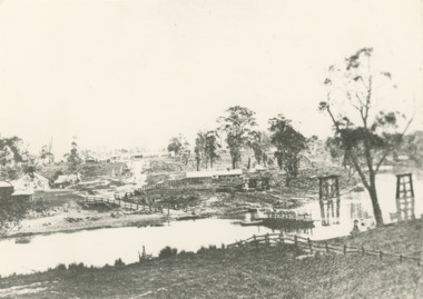
... Black and white photograph of the punt on the Mitchell River and the first bridge under construction. In distance can be seen the growing township of Bairnsdale Victoria...Lakes Entrance Historical Society 4 Marine Parade Lakes Entrance gippsland Boats and Boating Businesses Rivers Black and white photograph of the punt on the Mitchell River and the first bridge under construction. In distance can be seen the growing township of Bairnsdale Victoria Photograph Mitchell River Bairnsdale Victoria F Cornell ...Black and white photograph of the punt on the Mitchell River and the first bridge under construction. In distance can be seen the growing township of Bairnsdale Victoriaboats and boating, businesses, rivers -
Glenelg Shire Council Cultural Collection
Postcard - Postcard - Nelson, Victoria, n.d
... Coloured photo postcard, aerial view of Nelson, Victoria, showing the bridge, township and river mouth. Rose Series De Luxe colorview NO 1213...'Aerial view of Nelson Victoria' Coloured photo postcard, aerial view of Nelson, Victoria, showing the bridge, township and river mouth. Rose Series De Luxe colorview NO 1213 Postcard Postcard - Nelson, Victoria ROSE STEREOGRAPHIC CO PTY LTD ...Coloured photo postcard, aerial view of Nelson, Victoria, showing the bridge, township and river mouth. Rose Series De Luxe colorview NO 1213Back: Maker details. 'Aerial view of Nelson Victoria'postcard, nelson -
 Clunes Museum
Photograph, BAWDEN PHOTOGRAPHER, CIRCA 1890
... (SUSPENSION BRIDGE IN FOREGROUND)...ABOUT 1890 - NOTE GOVERNMENT BRIDGE IN DISTANCE. THIS WAS REBUILT IN STRAIGHT STEEL GIRDERS IN 1896. local history photography bridges - buildings and landscape of clunes ORIGINAL SEPIA PHOTOGRAPH OF TULLAROOP CREEK, IN FOREGROUND VIEWS OF CLUNES TOWNSHIP. ...TULLAROOP CREEK FROM "ROCKS" NEAR SITE OF PORT PHILLIP MINE. ABOUT 1890 - NOTE GOVERNMENT BRIDGE IN DISTANCE. THIS WAS REBUILT IN STRAIGHT STEEL GIRDERS IN 1896.ORIGINAL SEPIA PHOTOGRAPH OF TULLAROOP CREEK, IN FOREGROUND VIEWS OF CLUNES TOWNSHIP. TWO MILE HILL IN LEFT FAR DISTANCE. (SUSPENSION BRIDGE IN FOREGROUND)local history, photography, bridges - buildings and landscape of clunes -
 Lakes Entrance Historical Society
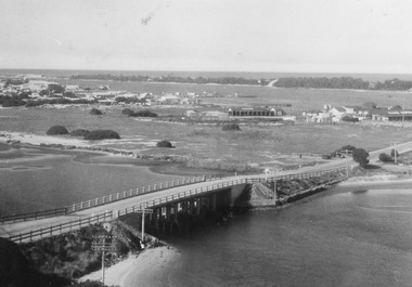
Photograph - Aerial view of North Arm Bridge c1930, 1930c
... Bridges...Bridges Township Black and white photograph concrete bridge over North Arm, two people at southern end of bridge, swampy area approaching Club Hotel. ...Black and white photograph concrete bridge over North Arm, two people at southern end of bridge, swampy area approaching Club Hotel. Lakes Entrance Victoriabridges, township -
 Lakes Entrance Historical Society
Postcard - North Arm bridge Lakes Entrance Victoria c1940, Bulmer, H D
... Bridges...Bridges Township Black and white postcard of bridge across North Arm, showing post and rail fences on abutments; low tide in North Arm; town buildings and Club Hotel, Cunninghame Arm and sand hummocks with ocean in far distance. ...Black and white postcard of bridge across North Arm, showing post and rail fences on abutments; low tide in North Arm; town buildings and Club Hotel, Cunninghame Arm and sand hummocks with ocean in far distance. Lakes Entrance Victoriabridges, township -
 Lakes Entrance Historical Society
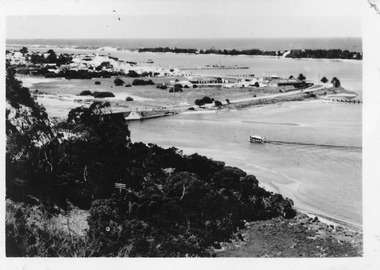
Postcard - North Arm bridge Lakes Entrance Victoria c1950, Bulmer H D
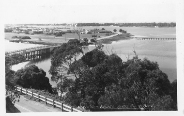
... Bridges...3 Identical small format postcards 9 x 14 Bridges Township Lakes Entrance from Jemmys Point Black and white small format postcard showing the town, North Arm bridge, Cunninghame Arm, sand hummocks, boat harbour, tourist launch approaching North Arm, power poles on lower side of road cutting. ...3 Identical small format postcards 9 x 14Black and white small format postcard showing the town, North Arm bridge, Cunninghame Arm, sand hummocks, boat harbour, tourist launch approaching North Arm, power poles on lower side of road cutting. Lakes Entrance VictoriaLakes Entrance from Jemmys Pointbridges, township -
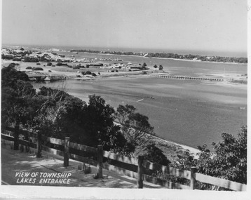 Lakes Entrance Historical Society
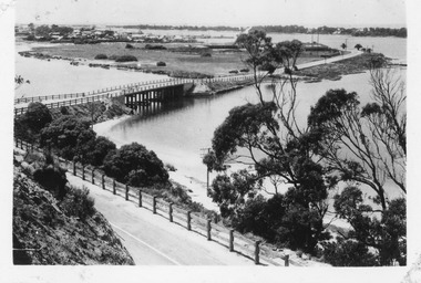
Postcard - North Arm bridge Lakes Entrance Victoria c1947
... Bridges...Bridges Township View of Township Lakes Entrance Black and white small format postcard showing town, North Arm bridge, post and rail fence beside the road, bridge to Bullock Island, Cunninghame Arm and sand hummocks, motor boat on the lake. ...Black and white small format postcard showing town, North Arm bridge, post and rail fence beside the road, bridge to Bullock Island, Cunninghame Arm and sand hummocks, motor boat on the lake. Lakes Entrance VictoriaView of Township Lakes Entrancebridges, township