Showing 3170 items matching "transport - roads"
-
 Port Melbourne Historical & Preservation Society
Newspaper - Rescue of Mr Hendy by Arthur Downer, J Kitchen & Sons driver, 9 Feb 1918
... ...Transport - Roads...Port Melbourne Historical & Preservation Society Port Melbourne Town Hall 333 Bay Street Port Melbourne melbourne Industry - Manufacturing Transport - Roads Sport - Swimming J Kitchen & Sons Pty Ltd Arthur DOWNER Port Melbourne Swimming Club Mr HENDY The Royal Humane Society of Australasia written in ink at the bottom of the page Photocopy of download of item from Port Melbourne Standard (Vic 1914 - 1920), Saturday 9th February 1918. ...Photocopy of download of item from Port Melbourne Standard (Vic 1914 - 1920), Saturday 9th February 1918. The rescue of a Mr HENDY by J Kitchen and Sons driver, Arthur DOWNERThe Royal Humane Society of Australasia written in ink at the bottom of the pageindustry - manufacturing, transport - roads, sport - swimming, j kitchen & sons pty ltd, arthur downer, port melbourne swimming club, mr hendy -
Port Melbourne Historical & Preservation Society
Book, Universal Business Directories (Aust) Pty Ltd, Universal DeLuxe Streets Directory, 1959
... Transport - Roads...Port Melbourne Historical & Preservation Society Port Melbourne Town Hall 333 Bay Street Port Melbourne melbourne Transport - Roads Street Directory 1959 Streets Directory for Melbourne City and Suburbs including large scale maps, hospitals, schools, police stations, town halls, telephone booths, tram stops, railways. ...1959 Streets Directory for Melbourne City and Suburbs including large scale maps, hospitals, schools, police stations, town halls, telephone booths, tram stops, railways. Fifth edition. Red and Buff cardboard cover, red binding.transport - roads, street directory -
 Port Melbourne Historical & Preservation Society
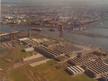
Photograph - Aerial view of West Gate Bridge under construction, 1960 - 1979
... ...Transport - Roads...Port Melbourne Historical & Preservation Society Port Melbourne Town Hall 333 Bay Street Port Melbourne melbourne Engineering - Bridges Fishermans Bend Built Environment - Industrial West Gate Bridge Rotten Row Piers and Wharves - MHT Timber Wharves Williamstown Yarra River Transport - Shipping Transport - Roads Commonwealth Aircraft Corporation Government Aircraft Factory "Master copy. ...Colour aerial photograph of West Gate Bridge under construction. Fishermans Bend factories in foreground. Ship in the river and view to Spotswood, Newport and Williamstown."Master copy. Not to be removed from marketing Department" stamped on top right corner and on backengineering - bridges, fishermans bend, built environment - industrial, west gate bridge, rotten row, piers and wharves - mht timber wharves, williamstown, yarra river, transport - shipping, transport - roads, commonwealth aircraft corporation, government aircraft factory -
 Port Melbourne Historical & Preservation Society
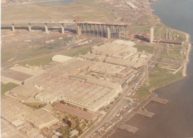
Photograph - Aerial view of West Gate Bridge under construction, 1960 - 1979
... ...Transport - Roads...Port Melbourne Historical & Preservation Society Port Melbourne Town Hall 333 Bay Street Port Melbourne melbourne Engineering - Bridges Fishermans Bend Built Environment - Industrial West Gate Bridge Rotten Row Piers and Wharves - MHT Timber Wharves Yarra River Transport - Shipping Transport - Roads Commonwealth Aircraft Corporation Government Aircraft Factory "Master Copy . ...Colour aerial (faded) photograph of West Gate Bridge under construction with two land spans incomplete. "Rotten Row" (disused old piers original constructed in 1889 by MHT) in the foreground. Aircraft factory and other industry in foreground."Master Copy . Not to be removed from Marketing department " lightly stamped on photo. and on rearengineering - bridges, fishermans bend, built environment - industrial, west gate bridge, rotten row, piers and wharves - mht timber wharves, yarra river, transport - shipping, transport - roads, commonwealth aircraft corporation, government aircraft factory -
 Port Melbourne Historical & Preservation Society
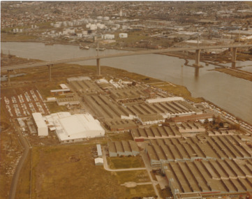
Photograph - Aerial view of West Gate Bridge under construction, c1979
... ...Transport - Roads...Engineering - Bridges Fishermans Bend Built Environment - Industrial West Gate Bridge Yarra River Transport - Roads Piers and Wharves - MHT Timber Wharves Rotten Row Demolitions Commonwealth Aircraft Corporation Government Aircraft Factory "Gov't A/C Factories Photographic Section Neg No N2841/3" stamped on back Colour aerial photograph of West Gate Bridge completed. ...The wharf part of "Rotten Row" can be seen along the river bank in this photograph however the finger jetties visible in earlier photographs (3662.01 and 3662.02) have been removed.Colour aerial photograph of West Gate Bridge completed. Aircraft factory and other industry in foreground. Spotswood and Newport and fuel storage tanks in background."Gov't A/C Factories Photographic Section Neg No N2841/3" stamped on backengineering - bridges, fishermans bend, built environment - industrial, west gate bridge, yarra river, transport - roads, piers and wharves - mht timber wharves, rotten row, demolitions, commonwealth aircraft corporation, government aircraft factory -
Port Melbourne Historical & Preservation Society
Document - 2011 Melway Greater Melbourne Street Directory, 2011
... ...transport - roads...Port Melbourne Historical & Preservation Society Port Melbourne Town Hall 333 Bay Street Port Melbourne melbourne built environment engineering - roads streets lanes and footpaths natural environment transport - roads streets mapping greater melbourne 2011 editions of Melway Greater Melbourne Street Directory Top quarter white, bottom blue background with photo of city Document 2011 Melway Greater Melbourne Street Directory Melway Publishing McPherson Printing Group ...2011 editions of Melway Greater Melbourne Street Directory Top quarter white, bottom blue background with photo of citybuilt environment, engineering - roads streets lanes and footpaths, natural environment, transport - roads, streets, mapping, greater melbourne -
Port Melbourne Historical & Preservation Society
Document - Reports, Planning, development and traffic management, Loder & Bayly, 1974 - 1978
... ...transport - roads...Port Melbourne Historical & Preservation Society Port Melbourne Town Hall 333 Bay Street Port Melbourne melbourne local government - city of port melbourne town planning transport - roads built environment - commercial built environment - zoning loder & bayly glen cosham 12 surveys re planning, development and traffic management carried out by Loder & Bayly, August 1974 to February 1978 Document Reports, Planning, development and traffic management Loder & Bayly ...12 surveys re planning, development and traffic management carried out by Loder & Bayly, August 1974 to February 1978local government - city of port melbourne, town planning, transport - roads, built environment - commercial, built environment - zoning, loder & bayly, glen cosham -
Port Melbourne Historical & Preservation Society
Photograph - Various photos related to John James GILCHRIST, John Gilcrist, 1940s - 1950s
... ...Transport - roads...Port Melbourne Historical & Preservation Society Port Melbourne Town Hall 333 Bay Street Port Melbourne melbourne From John Gilcrist via Janet Bolitho Piers and wharves - Station Pier Piers and Wharves - Princes pier Built Environment Transport - roads McCormack Street John GILCHRIST John James GILCHRIST Mary Eileen GILCHRIST 13 photos from John GILCHRIST showing his father, John James GILCHRIST, at Station Pier and Princes Pier, a view from the Shrine of Remembrance, Centenary Bridge, and his father and mother, Eileen Mary GILCHRIST at their home at 16 McCormack Street Port Melbourne .01 - Princes Pier, Taroona, Port Hobart .02 - View from Shrine overlooking Albert Park Lake .03 - Between piers .04 - Princes Pier at night .05 - From Station Pier West finger pier .06 - House at 16 McCormack Street. ...From John Gilcrist via Janet Bolitho13 photos from John GILCHRIST showing his father, John James GILCHRIST, at Station Pier and Princes Pier, a view from the Shrine of Remembrance, Centenary Bridge, and his father and mother, Eileen Mary GILCHRIST at their home at 16 McCormack Street Port Melbourne .01 - Princes Pier, Taroona, Port Hobart .02 - View from Shrine overlooking Albert Park Lake .03 - Between piers .04 - Princes Pier at night .05 - From Station Pier West finger pier .06 - House at 16 McCormack Street. (No. 12 McCormack Street also shown) .07 - Centenary Bridge1949-50 .08 - Outside 16 McCormack Street, showing Singer car. (Nos. 22, 24 & 26 McCormack Street also shown) .09 - John and Eileen Gilcrist in backyard .10 - South side of house at 16 McCormack Street .11 - South side of house at 16 McCormack Street .12 - Photo of Edwards Park .13 - East side of house at 16 McCormack Street Refer also to hand drawn plan of house and outbuildings at catalogue no. 2763piers and wharves - station pier, piers and wharves - princes pier, built environment, transport - roads, mccormack street, john gilchrist, john james gilchrist, mary eileen gilchrist -
 Port Melbourne Historical & Preservation Society
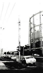
Photograph - Graham Street towards Albert Park, Reverend Donald LANGFORD, June 1973
... ...Transport - Roads...Built Environment - Industrial Transport - Roads Education - Secondary Schools Gasometer Demolitions B & W photograph of Graham Street, Port Melbourne looking towards Pickles Street. ...Taken from the corner of Seisman Place looking towards Albert Park, the photograph was taken before the demolition of the gasometer shown on the on right. The original Albert Park High School can be seen behind the Pickles Street sign.B & W photograph of Graham Street, Port Melbourne looking towards Pickles Street.built environment - industrial, transport - roads, education - secondary schools, gasometer, demolitions -
Port Melbourne Historical & Preservation Society
Book - Melway Greater Melbourne Street Directory, Melway, 1990 - 2009
... ...transport - roads...Port Melbourne Historical & Preservation Society Port Melbourne Town Hall 333 Bay Street Port Melbourne melbourne built environment engineering - roads streets lanes and footpaths natural environment transport - roads melbourne streets mapping Four editions of Melway Greater Melbourne Street Directory .01 Edition 20 (1990) - Reg Yellow and green vertical banded cover .02 Edition 24 (1994) - Green, orange, white cover .03 Edition 32 (2005) - Dark and light blue cover .04 Edition 36 (2009) - White, red and black cover Book Melway Greater Melbourne Street Directory Melway ...Four editions of Melway Greater Melbourne Street Directory .01 Edition 20 (1990) - Reg Yellow and green vertical banded cover .02 Edition 24 (1994) - Green, orange, white cover .03 Edition 32 (2005) - Dark and light blue cover .04 Edition 36 (2009) - White, red and black coverbuilt environment, engineering - roads streets lanes and footpaths, natural environment, transport - roads, melbourne, streets, mapping -
 Port Melbourne Historical & Preservation Society
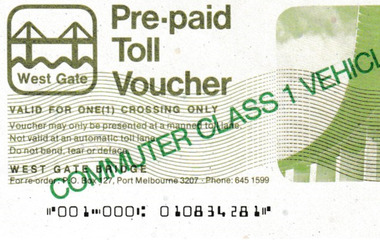
Document - Pre-paid Toll Vouchers for West Gate Bridge, 1980
... ...Transport - Roads...Transport - Motor Vehicles Transport - Roads West Gate Bridge Two unused white Pre-paid Toll Vouchers.' ...From the collection of Warren DOUBLEDAY. Bridge tolls were imposed from its opening in 1978 until they were removed in 1985.Two unused white Pre-paid Toll Vouchers.' Commuter Class 1 Vehicle Only' is written in green across both the front and back, The West Gate logo is in the top left corner.transport - motor vehicles, transport - roads, west gate bridge -
 Port Melbourne Historical & Preservation Society
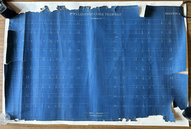
Plan, Pt Melbourne Cable Tramway, 1890s
... ...Transport - Roads...Port Melbourne Historical & Preservation Society Port Melbourne Town Hall 333 Bay Street Port Melbourne melbourne Transport - tramways Transport - Roads Notations in red crayon or pencil One of three sheets of blueprints showing street configuration in Beach Street and Sandridge Road along Port Melbourne cable tram route. ...One of three sheets of blueprints showing street configuration in Beach Street and Sandridge Road along Port Melbourne cable tram route. Indistinguishable signature of 'George ------ Esq., lower rightNotations in red crayon or penciltransport - tramways, transport - roads -
Port Melbourne Historical & Preservation Society
Book - Mac's Trade Professional & Street Directory of Melbourne, 1940s
... transport - roads...Port Melbourne Historical & Preservation Society Port Melbourne Town Hall 333 Bay Street Port Melbourne melbourne transport - roads edwin whiting Mac's Trade Professional & Street Directory of Melbourne, early 1940's Book Mac's Trade Professional & Street Directory of Melbourne H E C Robinson ...Mac's Trade Professional & Street Directory of Melbourne, early 1940'stransport - roads, edwin whiting -
Port Melbourne Historical & Preservation Society
Book - Robinson's Street Directory of Melbourne, 1940s
... transport - roads...Port Melbourne Historical & Preservation Society Port Melbourne Town Hall 333 Bay Street Port Melbourne melbourne transport - roads edwin whiting Robinson's Street Directory of Malbourne, early 1960s Book Robinson's Street Directory of Melbourne H E C Robinson ...Robinson's Street Directory of Malbourne, early 1960stransport - roads, edwin whiting -
Port Melbourne Historical & Preservation Society
Photograph - COR road tanker, Beach Street, Port Melbourne, Douglas Smallpage, 1940s
... Transport - Roads...Port Melbourne Historical & Preservation Society Port Melbourne Town Hall 333 Bay Street Port Melbourne melbourne Transport - Roads Business and Traders Commonwealth Oil Refineries COR Several have descriptions of locations in pencil on rear of photos B&W photos of various locations in Port Melbourne COR road tanker on Beach St in 1940s Photograph COR road tanker, Beach Street, Port Melbourne Douglas Smallpage ...B&W photos of various locations in Port Melbourne COR road tanker on Beach St in 1940sSeveral have descriptions of locations in pencil on rear of photostransport - roads, business and traders, commonwealth oil refineries, cor -
Port Melbourne Historical & Preservation Society
Photograph - Aerial view showing route of Lower Yarra Crossing Project (West Gate Bridge), Apr 1966
... ...transport - roads...Port Melbourne Historical & Preservation Society Port Melbourne Town Hall 333 Bay Street Port Melbourne melbourne west gate bridge transport - roads engineering - bridges 'Lower Yarra Crossing Project' '296769' Black and white aerial photomap showing the proposed route of the Lower Yarra Crossing Project, later to become the West Gate Bridge and Freeway. ...Black and white aerial photomap showing the proposed route of the Lower Yarra Crossing Project, later to become the West Gate Bridge and Freeway. April 1966'Lower Yarra Crossing Project' '296769'west gate bridge, transport - roads, engineering - bridges -
Port Melbourne Historical & Preservation Society
Book - Collins Melbourne Street Directory, 1950s
... transport - roads...Port Melbourne Historical & Preservation Society Port Melbourne Town Hall 333 Bay Street Port Melbourne melbourne From Glen Stuart - used by his father, William Raeburn Stuart. transport - roads william raeburn stuart Collins Melbourne Street Directory c1950s Book Collins Melbourne Street Directory Collins Book Depot Premier Printing Co ...From Glen Stuart - used by his father, William Raeburn Stuart.Collins Melbourne Street Directory c1950stransport - roads, william raeburn stuart -
Port Melbourne Historical & Preservation Society
Document - Submission, Inquiry into "Land Transport to Webb Dock", 1981
... ...transport - roads...Port Melbourne Historical & Preservation Society Port Melbourne Town Hall 333 Bay Street Port Melbourne melbourne Submissions concern impacts, implications and future directions regarding freight movement into and out of Webb Dock. port of melbourne authority transport - railways transport - roads local government - city of port melbourne webb dock urban freight group bill saggers Submissions and transcripts from the State Development Committee "Inquiry into Land Transport to Webb Dock", 1981 City Of Port Melbourne submission Document Submission, Inquiry into "Land Transport to Webb Dock" ...Submissions concern impacts, implications and future directions regarding freight movement into and out of Webb Dock.Submissions and transcripts from the State Development Committee "Inquiry into Land Transport to Webb Dock", 1981 City Of Port Melbourne submissionport of melbourne authority, transport - railways, transport - roads, local government - city of port melbourne, webb dock, urban freight group, bill saggers -
Port Melbourne Historical & Preservation Society
Document - Submission, Inquiry into "Land Transport to Webb Dock", 1981
... ...transport - roads...Port Melbourne Historical & Preservation Society Port Melbourne Town Hall 333 Bay Street Port Melbourne melbourne Submissions concern impacts, implications and future directions regarding freight movement into and out of Webb Dock. port of melbourne authority transport - railways transport - roads local government - city of port melbourne webb dock urban freight group bill saggers "Bill Saggers highlighted aspects of the written submission to be presented verbally by Bill Saggers" Submissions and transcripts from the State Development Committee Inquiry into "Land Transport to Webb Dock", 1981 Bill Saggers submission Document Submission, Inquiry into "Land Transport to Webb Dock" ...Submissions concern impacts, implications and future directions regarding freight movement into and out of Webb Dock.Submissions and transcripts from the State Development Committee Inquiry into "Land Transport to Webb Dock", 1981 Bill Saggers submission"Bill Saggers highlighted aspects of the written submission to be presented verbally by Bill Saggers"port of melbourne authority, transport - railways, transport - roads, local government - city of port melbourne, webb dock, urban freight group, bill saggers -
Port Melbourne Historical & Preservation Society
Document - Submission, Inquiry into "Land Transport to Webb Dock", 1981
... ...transport - roads...Port Melbourne Historical & Preservation Society Port Melbourne Town Hall 333 Bay Street Port Melbourne melbourne Submissions concern impacts, implications and future directions regarding freight movement into and out of Webb Dock. port of melbourne authority transport - railways transport - roads local government - city of port melbourne webb dock urban freight group bill saggers "RPW" Submissions and transcripts from the State Development Committee "Inquiry into "Land Transport to Webb Dock", 1981 Urban Freight Group submission Document Submission, Inquiry into "Land Transport to Webb Dock" ...Submissions concern impacts, implications and future directions regarding freight movement into and out of Webb Dock.Submissions and transcripts from the State Development Committee "Inquiry into "Land Transport to Webb Dock", 1981 Urban Freight Group submission"RPW"port of melbourne authority, transport - railways, transport - roads, local government - city of port melbourne, webb dock, urban freight group, bill saggers -
Port Melbourne Historical & Preservation Society
Document - Transcript, Inquiry into "Land Transport to Webb Dock", 1981
... ...transport - roads...Port Melbourne Historical & Preservation Society Port Melbourne Town Hall 333 Bay Street Port Melbourne melbourne Submissions concern impacts, implications and future directions regarding freight movement into and out of Webb Dock. port of melbourne authority transport - railways transport - roads local government - city of port melbourne webb dock urban freight group bill saggers "RPW" Submissions and transcripts from the State Development Committee "Inquiry into "Land Transport to Webb Dock", 1981 Transcript of Proceedings, 25.08, 1981 Document Transcript, Inquiry into "Land Transport to Webb Dock" ...Submissions concern impacts, implications and future directions regarding freight movement into and out of Webb Dock.Submissions and transcripts from the State Development Committee "Inquiry into "Land Transport to Webb Dock", 1981 Transcript of Proceedings, 25.08, 1981"RPW"port of melbourne authority, transport - railways, transport - roads, local government - city of port melbourne, webb dock, urban freight group, bill saggers -
Port Melbourne Historical & Preservation Society
Book - Morgans Street Directory, 1948
... transport - roads...Port Melbourne Historical & Preservation Society Port Melbourne Town Hall 333 Bay Street Port Melbourne melbourne transport - roads john may les murphy 1948 Morgans Street Directory Book Morgans Street Directory Troedel and Cooper ...1948 Morgans Street Directorytransport - roads, john may, les murphy -
Port Melbourne Historical & Preservation Society
Photograph - Three Cranes, R Knight Pty Ltd
... ...Transport - Roads...Port Melbourne Historical & Preservation Society Port Melbourne Town Hall 333 Bay Street Port Melbourne melbourne R Knight Pty Ltd Transport - Roads Cranes Cruikshank Street Digital colour photograph of three cranes parked in front of a shed with a man standing in front of them at R Knight Pty Ltd in Cruikshank Street. ...Digital colour photograph of three cranes parked in front of a shed with a man standing in front of them at R Knight Pty Ltd in Cruikshank Street.r knight pty ltd, transport - roads, cranes, cruikshank street -
Port Melbourne Historical & Preservation Society
Photograph - Model T Truck, R Knight Pty Ltd
... ...Transport - Roads...Port Melbourne Historical & Preservation Society Port Melbourne Town Hall 333 Bay Street Port Melbourne melbourne R Knight Pty Ltd Transport - Roads Cruikshank Street Digital colour photograph of a vintage R Knight Model T truck parked in front of their former stable in Cruikshank Street. ...Digital colour photograph of a vintage R Knight Model T truck parked in front of their former stable in Cruikshank Street. Set up for an historic vehicle parade.r knight pty ltd, transport - roads, cruikshank street -
Port Melbourne Historical & Preservation Society
Photograph - Loading a Wooden Panel, R Knight Pty Ltd
... ...Transport - Roads...Port Melbourne Historical & Preservation Society Port Melbourne Town Hall 333 Bay Street Port Melbourne melbourne R Knight Pty Ltd Transport - Roads Cranes Digital colour photograph of two men from R Knight Pty Ltd loading a large wooden panel onto a low loader. ...Digital colour photograph of two men from R Knight Pty Ltd loading a large wooden panel onto a low loader. On man is driving a crane while the second is working on top of the panel.r knight pty ltd, transport - roads, cranes -
Port Melbourne Historical & Preservation Society
Photograph - Wooden Panels on a Low Loader, R Knight Pty Ltd, early 1970s
... ...Transport - Roads...Port Melbourne Historical & Preservation Society Port Melbourne Town Hall 333 Bay Street Port Melbourne melbourne R Knight Pty Ltd Transport - Roads A digital colour photograph of a man sitting on top of several large wooden panels on a R Knight Pty Ltd low loader. ...A digital colour photograph of a man sitting on top of several large wooden panels on a R Knight Pty Ltd low loader. Another R Knight truck is parked nearby. At Liner Services.r knight pty ltd, transport - roads -
Port Melbourne Historical & Preservation Society
Photograph - R Knight Pty Ltd, Cruikshank St
... ...Transport - Roads...Port Melbourne Historical & Preservation Society Port Melbourne Town Hall 333 Bay Street Port Melbourne melbourne R Knight Pty Ltd Transport - Roads Jackie PERKINS Cruikshank Street Digital colour photograph of a man walking past the original stable building of R Knight Pty Ltd in Cruikshank Street and the double-fronted weatherboard cottage next door used as the caretaker, Jackie PERKINS, residence. ...Digital colour photograph of a man walking past the original stable building of R Knight Pty Ltd in Cruikshank Street and the double-fronted weatherboard cottage next door used as the caretaker, Jackie PERKINS, residence.r knight pty ltd, transport - roads, jackie perkins, cruikshank street -
Port Melbourne Historical & Preservation Society
Photograph - R Knight Pty Ltd Yard, Cruikshank St, c1980s
... ...Transport - Roads...Port Melbourne Historical & Preservation Society Port Melbourne Town Hall 333 Bay Street Port Melbourne melbourne R Knight Pty Ltd Transport - Roads Jackie PERKINS Cruikshank Street Digital colour photograph of a double-fronted weatherboard cottage (caretaker Jackie PERKINS residence) and R Knight Pty Ltd's yard in Cruikshank Street. ...Digital colour photograph of a double-fronted weatherboard cottage (caretaker Jackie PERKINS residence) and R Knight Pty Ltd's yard in Cruikshank Street.r knight pty ltd, transport - roads, jackie perkins, cruikshank street -
 Port Melbourne Historical & Preservation Society
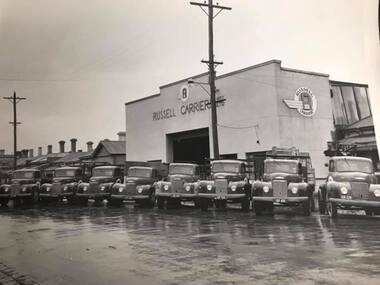
Photograph - Trucks outside Russell Carriers Pty Ltd
... ...Transport - Roads...Port Melbourne Historical & Preservation Society Port Melbourne Town Hall 333 Bay Street Port Melbourne melbourne Ross Street Russell Carriers Pty Ltd Transport - Roads Digital copy of a B&W photograph of 8 trucks lined up in Ross Street outside Russell Carriers Pty Ltd. ...Digital copy of a B&W photograph of 8 trucks lined up in Ross Street outside Russell Carriers Pty Ltd.ross street, russell carriers pty ltd, transport - roads -
 Port Melbourne Historical & Preservation Society
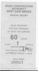
Document - West Gate Bridge Official Receipt 60c
... ...Transport - Roads...Port Melbourne Historical & Preservation Society Port Melbourne Town Hall 333 Bay Street Port Melbourne melbourne West Gate Bridge Engineering - Bridges Transport - Roads Digital B&W photograph of an official receipt for 60 cents for one crossing of West Gate Bridge for a Class 1 Vehicle. ...Digital B&W photograph of an official receipt for 60 cents for one crossing of West Gate Bridge for a Class 1 Vehicle.west gate bridge, engineering - bridges, transport - roads