Showing 45 items matching "trestle way"
-
 Bendigo Historical Society Inc.
Photograph - Napoleon Gold Mine Trestle Way, 1935
... Napoleon Gold Mine Trestle Way...Black and white photograph: two sections of trestle way, power poles in foreground. Rock pile almost directly directly under trestleway. ...Photograph Napoleon Gold Mine Trestle Way ...Significant to mining history of Bendigo.Black and white photograph: two sections of trestle way, power poles in foreground. Rock pile almost directly directly under trestleway. Wall of mine shed right hand side Low forested hills in far background.Written in pencil on back of photograph : 'Napoleon trestles completed and first truck tipped 14/9/35'. Further date unattributed 17.9.35'napoleon gold mine, trestleway, ore -
 Bendigo Historical Society Inc.
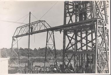
Photograph - Carshalton Trestleway, 1935
... ...Trestle way...Black and white photograph : image shows Carshalton headframe and erection of trestle way. Image shows erection of supports for trestle way. ...Carshalton Gold Mine Diesel Compressor Winder Trestle way Written in pencil on back of photograph in black pen: 'Carshalton trestles erected 22.8.35 ' Black and white photograph : image shows Carshalton headframe and erection of trestle way. ...Significant to mining history of Bendigo.Black and white photograph : image shows Carshalton headframe and erection of trestle way. Image shows erection of supports for trestle way. Man standing on track of trestleway.Written in pencil on back of photograph in black pen: 'Carshalton trestles erected 22.8.35 'carshalton gold mine, diesel compressor, winder, trestle way -
 Bendigo Historical Society Inc.
Photograph - Carshalton Trestleway, 1935
... ...Trestle way...Black and white photograph : image shows Carshalton headframe and erection of trestle way....Carshalton Gold Mine Diesel Compressor Winder Trestle way Written in pencil on back of photograph in black pen: 'Carshalton erecting trestles 21.6.35 ' Black and white photograph : image shows Carshalton headframe and erection of trestle way. ...Significant to mining history of Bendigo.Black and white photograph : image shows Carshalton headframe and erection of trestle way.Written in pencil on back of photograph in black pen: 'Carshalton erecting trestles 21.6.35 'carshalton gold mine, diesel compressor, winder, trestle way -
 Bendigo Historical Society Inc.
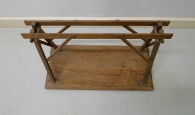
Leisure object - MODEL OF WOODEN TRESTLE
... Model of a trestle-way over. The trestle was attached to the poppet head and used to move the rocks over the crushing plant....History House 11 Mackenzie Street Bendigo goldfields MINING Equipment Trestle Model of a trestle-way over. The trestle was attached to the poppet head and used to move the rocks over the crushing plant. ...Model of a trestle-way over. The trestle was attached to the poppet head and used to move the rocks over the crushing plant.mining, equipment, trestle -
 Bendigo Historical Society Inc.
Photograph - Carshalton Trestleway, 1935
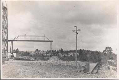
... Black and white photograph : image shows Carshalton headframe and trestle way. Electric power line and pole in foreground. ...Carshalton Gold Mine Written in pencil on back of photograph in black pen: 'Carshalton showing completed trestle 5.9.35 ' Black and white photograph : image shows Carshalton headframe and trestle way. Electric power line and pole in foreground. ...Significant to mining history of Bendigo.Black and white photograph : image shows Carshalton headframe and trestle way. Electric power line and pole in foreground. Pile of mullock at end of trestleway.Written in pencil on back of photograph in black pen: 'Carshalton showing completed trestle 5.9.35 'carshalton gold mine -
 Bendigo Historical Society Inc.
Photograph - Nell Gwynne (BML) Gold Mine, 1935
... ...Trestle way...Carshalton Gold Mine Diesel Compressor Winder Trestle way Written in pencil on back of photograph in black pen: ' Nell Gwynne '7.2.35 ' Black and white photograph : Nell Gwynne mine site. ...Significant to mining history of Bendigo.Black and white photograph : Nell Gwynne mine site. Corrugated iron mine buildings, head frame on right hand side of image, erection almost complete. Power lines in foreground. Written in pencil on back of photograph in black pen: ' Nell Gwynne '7.2.35 'carshalton gold mine, diesel compressor, winder, trestle way -
 Bendigo Historical Society Inc.
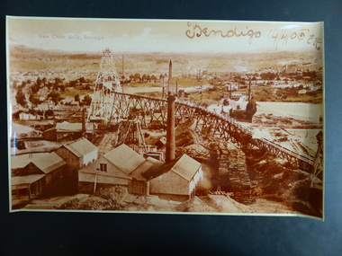
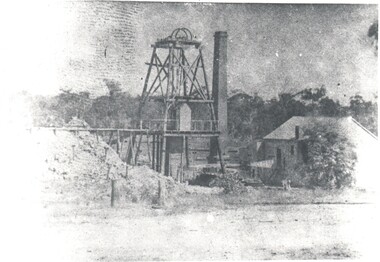
Photograph - NEW CHUM GULLY BENDIGO, 1906
... Sepia photograph New Chum Gully Bendigo showing a long Trestle way, Poppet head,various chimneys and assorted buildings, handwritten on top Bendigo 14/4/06 E.H...History House 11 Mackenzie Street Bendigo goldfields PHOTOGRAPH Landscape Gold Mine Bendigo-history-goldmines-New Chum Sepia photograph New Chum Gully Bendigo showing a long Trestle way, Poppet head,various chimneys and assorted buildings, handwritten on top Bendigo 14/4/06 E.H Photograph NEW CHUM GULLY BENDIGO ...Sepia photograph New Chum Gully Bendigo showing a long Trestle way, Poppet head,various chimneys and assorted buildings, handwritten on top Bendigo 14/4/06 E.Hphotograph, landscape, gold mine, bendigo-history-goldmines-new chum -
 Bendigo Historical Society Inc.
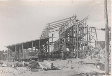
Photograph - Napoleon Ore Bins, 1935
... Black and white photograph: framework for ore bins at Napoleon (BML) Gold Mine, being erected alongside head frame at mine site. Trestle way visible in extreme top of image. ...Napoleon Gold Mine anticline Written in pencil on back of photograph : 'Erecting ore bins at Napoleon 27/8/56' Black and white photograph: framework for ore bins at Napoleon (BML) Gold Mine, being erected alongside head frame at mine site. Trestle way visible in extreme top of image. Photograph Napoleon Ore Bins ...Significant to mining history of Bendigo.Black and white photograph: framework for ore bins at Napoleon (BML) Gold Mine, being erected alongside head frame at mine site. Trestle way visible in extreme top of image. Written in pencil on back of photograph : 'Erecting ore bins at Napoleon 27/8/56'napoleon gold mine, anticline -
 Bendigo Historical Society Inc.
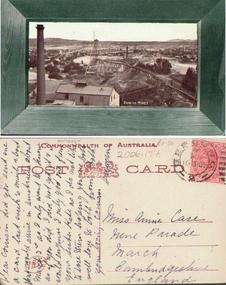
Photograph - VIEW OF BENDIGO MINES, c.1905
... Black and white postcard photograph of scenic view labelled 'Bendigo Mines' including building, poppet head, chimney, trestle way, hills in background. Small letter on back. ...History House 11 Mackenzie Street Bendigo goldfields PLACE Mining site Black and white postcard photograph of scenic view labelled 'Bendigo Mines' including building, poppet head, chimney, trestle way, hills in background. Small letter on back. ...Black and white postcard photograph of scenic view labelled 'Bendigo Mines' including building, poppet head, chimney, trestle way, hills in background. Small letter on back. Inscriptions: 'Bendigo Mines'. On back - letter to Miss Annie Case.place, mining site -
 Bendigo Historical Society Inc.
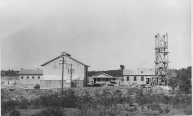
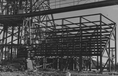
Photograph - Napoleon Mine Battery, 1936
... Right hand side of image, man standing on trestle way leading from battery to another mine building. ...Right hand side of image, man standing on trestle way leading from battery to another mine building. ...The Napoleon mine site was situated near Harvey Street and Union Street, Ironbark. It was registered under the Companies Act in 1940, with John Jepson Stanistreet as Manager. Article in Age newspaper: https://trove.nla.gov.au/newspaper/article/206767750?searchTerm=napoleon%20reef%20mineSignificant to mining history of Bendigo.Black and white photograph: battery shed under erection, partly clad in corrugated iron. Ladder resting on side of clad building. Right hand side of image, man standing on trestle way leading from battery to another mine building. Written in pencil on back of photograph: ' battery erection 9/11/36' and 'cracker station building'napoleon gold mine, napoleon reef gold mine -
 Bendigo Historical Society Inc.
Photograph - HARRY BIGGS COLLECTION: GOLD MINE
... Photograph with a wooden Poppet head centre of frame, there is a trestle way out to a tailings dump on the left hand side. ...History House 11 Mackenzie Street Bendigo goldfields ORGANIZATION Mining head frame Poppet head Gold Mine Photograph with a wooden Poppet head centre of frame, there is a trestle way out to a tailings dump on the left hand side. ...Photograph with a wooden Poppet head centre of frame, there is a trestle way out to a tailings dump on the left hand side. A square brick chimney is between the head frame and a wooden? Building on the right of the photo. In the foreground there is a roadway and a thick line of trees in the background. There are four copiesorganization, mining, head frame, poppet head, gold mine -
 Bendigo Historical Society Inc.
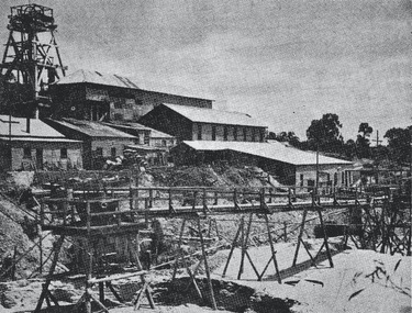
Photograph - Austin Collection: mine site
... Image shows poppet head in top left hand corner, with large mine sheds on slope below. Wooden trestle-way in immediate foreground. Written on back of image in pen ' 1952 sheet built around wooden poppet'...Image shows poppet head in top left hand corner, with large mine sheds on slope below. Wooden trestle-way in immediate foreground. Written on back of image in pen ' 1952 sheet built around wooden poppet' Photograph Austin Collection: mine site ...Photocopy contained in donation of mining imagesBlack and white photocopy of gold mine site, unnamed. Image shows poppet head in top left hand corner, with large mine sheds on slope below. Wooden trestle-way in immediate foreground. Written on back of image in pen ' 1952 sheet built around wooden poppet'gold mining, poppet head, trestleway -
 Bendigo Historical Society Inc.
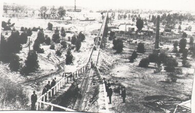
Photograph - HARRY BIGGS COLLECTION: NEW MOON TRAMWAY, Circa 1900
... The tramway extends from the foreground into the far distance, the tramway is in a cutting in the foreground and on a trestle way in the distance. There is a group of men standing around a railing fence looking at the tramway. ...The tramway extends from the foreground into the far distance, the tramway is in a cutting in the foreground and on a trestle way in the distance. There is a group of men standing around a railing fence looking at the tramway. ...Photograph of the New Moon battery Tramway, Eaglehawk. The tramway extends from the foreground into the far distance, the tramway is in a cutting in the foreground and on a trestle way in the distance. There is a group of men standing around a railing fence looking at the tramway. There is a large round brick chimney in the middle distance and another visible in the background.Robinsonplace, mining site, new moon, new moon, tramway, battery -
 Bendigo Historical Society Inc.
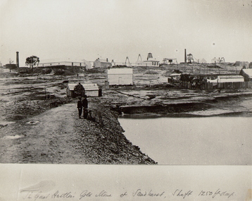
Photograph - THE GREAT HUSTLER GOLD MINE AT SANDHURST, c.1875
... Dam on RH side front, mine buildings (various) trestle way in background. Three people beside dam in foreground. ...Dam on RH side front, mine buildings (various) trestle way in background. Three people beside dam in foreground. ...Black and white photograph copy of original. Mining site of The Great Hustler, Gold Mine at Sandhurst. Dam on RH side front, mine buildings (various) trestle way in background. Three people beside dam in foreground. Brick chimney back LH side. Inscriptions: 'The Great Hustler, Gold Mine at Sandhurst. Shaft 1250 ft'.place, mining site, great extended hustler quartz mine -
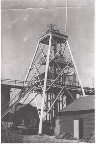 Bendigo Historical Society Inc.
Photograph - NORTH DEBORAH GOLD MINE
... Black and white photograph, copy, of the North Deborah Gold Mine poppet head, possibly taken in the 1940's. The trestle way and sky shaft used to convey ore to the landing brace are visible. ...History House 11 Mackenzie Street Bendigo goldfields BENDIGO Mining north deborah gold mine Black and white photograph, copy, of the North Deborah Gold Mine poppet head, possibly taken in the 1940's. The trestle way and sky shaft used to convey ore to the landing brace are visible. ...Black and white photograph, copy, of the North Deborah Gold Mine poppet head, possibly taken in the 1940's. The trestle way and sky shaft used to convey ore to the landing brace are visible. Poppet head legs are metal and painted white. Corrugated iron sheds on right and in background. Air raid sirens on the top of the poppet head were used during World War 2 to warn the good citizens of Bendigo of any impending attack.bendigo, mining, north deborah gold mine -
 Bendigo Historical Society Inc.
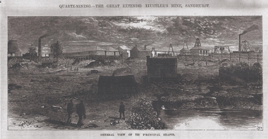
Photograph - Great Extended Hustlers Gold Mine Sandhurst, April, 2014
... Image shows mine buildings, trestle way, mine dam in foreground, poppet head in background. ...Image shows mine buildings, trestle way, mine dam in foreground, poppet head in background. ...Seven men were killed at the Great Extended Hustler's mine disaster on 2nd May 1914 by an explosion of dynamite occurring as the men were waiting at the plat to ascend the mine at the end of their shift. No blame was attached to anyone in the findings of the inquisition. It was unknown what caused the dynamite to explode. This document formed part of the research done at the time by Bendigo Historical Society, of the 100 years commemoration of the mine disaster, held at Hustler's Hill in 2014. Two pages of photocopies of images from the 'Australasian Sketcher' May 17th. 1873, of the Great Extended Hustlers Gold Mine Sandhurst. First page: across top of image 'Quartz Mining - The Great Extended Hustlers Mine, Sandhurst'. Across bottom of image ' General View of the Principal Shafts'. Image shows mine buildings, trestle way, mine dam in foreground, poppet head in background. Mining chimneys in background. Second page: same view as above with five small images of mine operations below; men underground, men in mine cate, man pushing ore truck. great extended hustlers, goldmining, accident, 1873 -
 Bendigo Historical Society Inc.
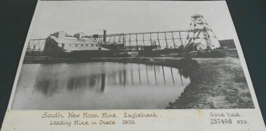
Photograph - SOUTH NEW MOON MINE EAGLEHAWK
... Image shows mining dam in forefront, large mine buildings and chimney LH side and trestle way connecting to poppet head on RH side. ...Image shows mining dam in forefront, large mine buildings and chimney LH side and trestle way connecting to poppet head on RH side. ...Black and white photograph (copy) of South New Moon Mine. Written on base of photograph : 'South New Moon Mine. Eaglehawk. Leading Mine in State, 1903. Gold Yield 257,498 ozs.' Image shows mining dam in forefront, large mine buildings and chimney LH side and trestle way connecting to poppet head on RH side. Smaller mine buildings in background. Photo on buff coloured backing board, enclosed in plastic, sealed at back. See: Victorian Heritage Database for history of site http://vhd.heritage.vic.gov.au/places/result_detail/12109?print=truegold mines, mining equipment, south new moon mine site -
 Bendigo Historical Society Inc.
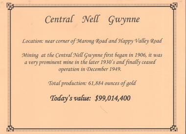
Document - CENTRAL NELL GWYNNE GOLD MINE
... Poppet head and engine room sheds on LH side, trestle way to primary crusher and crushing battery. ...Poppet head and engine room sheds on LH side, trestle way to primary crusher and crushing battery. ...Interpretive sign and 4 photos Central Nell Gwynne Gold Mine, used in display. Central Nell Gwynne was located near the corner of Marong Road and Happy Valley Road. Opened in 1906, ceased operation in December 1949. Total production: 61,884 ounces of Gold. Today's Value: $99,014,400. Photos: a. Colour photo, concrete footings at mine site, April 2012. b. Colour photo, Central Nell Gwynne poppet head, April 2012.Poppet head painted white with red trim. Concrete footings in foreround. c. Central Nell Gwynne mine site 1930's. Poppet head and engine room sheds on LH side, trestle way to primary crusher and crushing battery. Tailing dam in immediate foreground. on RH side. Sand heaps in middle foreground. d. Central Nell Gwynne Mine 1930. Underground view, men holding carbide lamps working at 265 level in mine. Large quartz spur formation visible in foreground.bendigo, mining, central nell gwynne -
 Emerald Museum & Nobelius Heritage Park
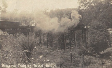
Photograph, Postcard, Belgrave Train on Trestle Bridge, 13/01/1914
... Emerald Museum & Nobelius Heritage Park 5 Crichton Rd Emerald yarra-valley-and-the-dandenong-ranges Early postcard of Puffing Billy on trestle bridge puffing billy belgrave whiteside Front: text, Belgrave Train on 'Tressel' Bridge Back: Handwritten text: 13/01/1914? Emerald - Dear Mother we are at Emerald, on our way ...Early postcard of Puffing Billy on trestle bridge Faded sepia photograph/postcard depicting Puffing Billy on Trestle BridgeFront: text, Belgrave Train on 'Tressel' Bridge Back: Handwritten text: 13/01/1914? Emerald - Dear Mother we are at Emerald, on our way to L. Pa? Everything is going well. Crarj/ys? are going Dande (Dandenong?) Father slept all night. Will write in a couple of days. Jesse's in good form stocking up provisions. No need to worry, Loving son Blair ?puffing billy, belgrave, whiteside -
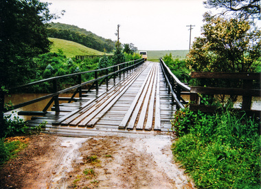
 Eltham District Historical Society Inc
Photograph, Tess Justine (Nillumbik Shire Council), Murray's Bridge over the Diamond Creek, Eltham North, 19 Feb 2022
... way between Eltham and Hurstbridge stations. The Railways Commissioners warned that the locals would have to fund these works themselves. The Glen Park Estate residents initially had difficulty accessing Eltham by road, with only an old low-level bridge over Diamond Creek at the south end of their estate. A new timber trestle...way between Eltham and Hurstbridge stations. The Railways Commissioners warned that the locals would have to fund these works themselves. The Glen Park Estate residents initially had difficulty accessing Eltham by road, with only an old low-level bridge over Diamond Creek at the south end of their estate. A new timber trestle ...Murray's Bridge over the Diamond Creek on the Diamond Creek Trail just prior to demolition and replacement with a new steel bridge. Heritage advice obtained by Nillumbik Shire Council, following a suggestion by the Eltham District Historical Society (EDHS), is that the original bridge appears to have been a simplified version of the Country Roads Board’s (CRB) standard timber bridge design of the early-to-mid 1920s. In c1990 Murray’s bridge was renovated with three recycled steel girders as part of a bike/pedestrian path in the reserve. During these alterations many parts of the bridge were removed, and some were replaced. Heritage advice indicates the condition of Murray’s bridge is poor. The remaining original parts are all in poor condition, with severe weathering, splitting and rot, especially to the stringers retained on the bridge. Heritage advice is that Murray’s Bridge does not have sufficient significance in the cultural history of the Nillumbik area to warrant inclusion in the Nillumbik Shire Heritage Overlay and also does not have sufficient significance as a rare survivor to warrant inclusion in the Nillumbik Shire Heritage Overlay. There are no indications in the historical record that this site was individually important to the cultural history of this area. EDHS is comfortable with the heritage advice provided to Council and has worked closely on this project with Council. EDHS has suggested some of the removed timbers be used in the vicinity of the bridge for landscaping and possibly seating, so as to retain these remnants close to the site of the original bridge, which is the last old timber bridge along the lower reaches of the Diamond Creek. Mary (Sweeney) Murray and John Wright Murray selected 80 acres, Lot C Section 16 and Lot 5 Section 17 Parish of Nillumbik, under an occupation license in 1866. John died in 1867 and freehold was granted to his son John in 1873. The farm was known as ‘Laurel Hill’. John Junior was an Eltham Shire councillor and sometime president from 1887 up until 1897. He added Lot A Section 16 to the farm in ca1888. John and his younger brother James arranged to rent/purchase Lot B Section 17, across Diamond Creek to the west, in ca1900. It appears that John and James farmed separately for a few years, with a new homestead built for James ad family on the high point of Lot B Section 17 in ca1910. John sold off Lot 5 Section 17 in 1912. When John died in 1912 James took over the land on both sides of the Diamond Creek. The old homestead on the west side of the Creek disappeared. A farm bridge over Diamond Creek from this period may have been located close to the northern boundary of the farm. John Langlands, owner of the farm known as ‘Ihurst’ on the west side of Diamond Creek to the south of the Murray’s land, died in 1907. In 1909 his land was then subdivided into 100 lots to become the ‘Glen Park Estate’. Other similar subdivisions of nineteenth century farms around Eltham in this period included the ‘Franktonia (or Beard’s) Estate’ to the northeast and ‘Bonsack’s Estate’ between Eltham and Greensborough. Soon after the opening of the railway extension line from Eltham to Hurstbridge in 1912, Glen Park and nearby residents including James Murray agitated for a railway station or siding to be located half-way between Eltham and Hurstbridge, so that the Glen Park residents who used the railway daily did not have to walk into the Eltham or Hurstbridge stations. Some believed Coleman’s Corner (opposite Edendale Farm) was an appropriate spot for the platform. James Murray was among those who thought the railway should be located on his land, closer to half-way between Eltham and Hurstbridge stations. The Railways Commissioners warned that the locals would have to fund these works themselves. The Glen Park Estate residents initially had difficulty accessing Eltham by road, with only an old low-level bridge over Diamond Creek at the south end of their estate. A new timber trestle bridge across the creek, now on Wattletree Road, was opened in 1915. Road access to the north was gained in 1927 when the new Murray’s Road, which crossed the Murray’s land, was built. Residents continued to agitate for a Glen Park station. By 1926 the Railways Commissioners’ preferred site was on the Murray’s land. They arranged an estimate of cost of a full-length platform. The estimate was too much for the locals, who in 1928 argued unsuccessfully for a shorter and hence cheaper platform. By 1929 Murray had agreed to donate the land, but the locals would still have to fund the works. Murray decided, unilaterally it would appear, to commence work on a timber trestle road bridge over Diamond Creek to link the new Murray Road to the proposed station. Late in 1929 he stopped work on the bridge, for reasons unknown, but started work again and completed the bridge in 1931. There is no further newspaper evidence of the campaign for the Glen Park station until 1939, when Murray and another local, Mr Maxwell, met the Railways Commissioner. The Glen Park locale now included 45 homes on the west side of the creek and 20 on the Eltham side. Most of the residents used the train every day. The Commissioner remained adamant that only a full-length platform could be built for safety reasons. It appears the campaign dissolved at this point. The increasing move to cars may have had an impact. There is no evidence of Murray’s bridge ever being connected to Murray’s Road, or of it having wide use for any purpose by locals. James Murray died in 1947 and the farm was taken over by his son James (Jim). Jim started to sell off parts of the farm in the 1980s, retaining a few acres around the ca1910 homestead and building a new house there. Recreation reserves were established along the creek. In ca1990 Murray’s bridge was renovated with steel girders as part of a bike/pedestrian path in the reserve. The old farmhouse was demolished in ca2014. * * * A theory posted on local community Facebook groups was that the bridge was built in the 1860s and was built to be more robust than was necessary for the movement of cows from one side of the creek to the other. It was suggested the robustness was necessary to support the weight of gold ore being transferred from a mine on Murray’s land to a railway siding near Murrays Bridge (presumably for transfer and processing at Diamond Creek). Perhaps this may have been one of the motivators for Murray, who really knows? Knowing when mining operations ceased on his land and how that fits the overall timeline would be useful but at the time the bridge was built, local gold production was minimal at best. The known facts are: • The railway line came to Eltham in 1902. • The extension of the railway from Eltham to Hurstbridge was constructed in 1912 so no railway line even existed through Murray's property until 1912 and the Victorian Railways maps at the time show no such siding on Murray’s property. • In 1923 a new company was formed in anticipation of the old Diamond Creek Gold Mine being re-opened. The mine had been previously closed and flooded. It was noted in the press at the time that the mine was within a mile of the railway. Nothing really came of this. • Construction of Murrays Bridge was commenced by James Murray in early 1929 in anticipation of a proposed flag station being nominated on his land, but work ceased shortly afterwards. The proposed flag station was commonly referred to as Glen Park as the residents of the Glen Park Estate wanted Option 1, located near them with the platform adjacent to Colemans corner. This was probably never going to fly as it was virtually in eyesight of Eltham station. Allandale Road was the third option, but the Commissioners' preferred option was No. 2 - on Murray's property. • The Railway Commissioners were not going to finance any such station and the works had to be funded by private landowners and residents, hence Murray investing in this himself. • Murray recommenced work two years later and finished his bridge in 1931 but unfortunately for him, the proposed flag station never eventuated. The bluestone siding you reference may well have been built by Murray as part of the proposed station platform. • Up until then, apart from the Main Road bridge, which was washed away in 1924, virtually all local crossings over the Diamond Creek were low lying bridges – Kaylocks Bridge at Brougham Street, Diamond Street bridge, Glen Park Road bridge. It is expected that Murray also had a low-lying bridge to connect his land either side of the creek. These were all washed away or severely damaged multiple times in the 1920s. Lessons were learnt, and Murrays Bridge appears to have been built in accordance with Country Road Board standards of the time. Flood damage was ongoing, and even more recently constructed raised bridges kept getting washed away, e.g., the new Wattle Tree Road bridge in 1958 just months after completion. Murray’s bridge was reinforced with steel some 30 years ago presumably to provide additional floodwater resistance, given the history of bridges disappearing in floodwaters. • In March 1932 it was reported in the Advertiser that there were still some prospectors operating around Eltham North who apart from further scarring the face of the earth over the previous two years had gained significant experience but little gold - hardly a driving factor for constructing a dedicated railway siding and bridge to transfer gold ore. It is far more probable that James Murray was hoping to have the railway station located on his property and invested his money by building the bridge to lead to it as well as a station platform. Had the station eventuated, it may well have driven up the value of his land for subdivision and new housing estates like the Glen Park Estate. That did not eventuate. Whilst the bridge was indeed old (90 years), the core structure being completed in 1931, it had been modified substantially from original and hence had no significant historic value – i.e., it was not a representative example of its type, construction, and age. Given that the bridge was not worthy of saving, the Eltham District Historical Society with Council’s support, and the Eltham Woodworkers group endeavoured to see what suitable sized timbers were salvageable to fabricate a commemorative seat. Unfortunately, the experts at the Woodworkers group were unable to salvage any suitable length/width timbers to fabricate the seat due to the presence of rot. Last remaining wooden trestle bridge on the Diamond Creek Trail just prior to demolition and replacementBorn digital image (27)diamond creek (creek), diamond creek trail, murrays bridge, ‘laurel hill’, john wright murray, mary (sweeney) murra, john murray jnr, james murray, john langlands, ‘ihurst’, ‘glen park estate’, beard's estate, franktonia, bonsack's estate, glen park estate, glen park railway station -
 Eltham District Historical Society Inc
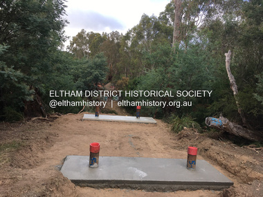
Photograph, Tess Justine (Nillumbik Shire Council), Construction work on replacement of Murray's Bridge over the Diamond Creek, Eltham North, 31 Mar 2022
... way between Eltham and Hurstbridge stations. The Railways Commissioners warned that the locals would have to fund these works themselves. The Glen Park Estate residents initially had difficulty accessing Eltham by road, with only an old low-level bridge over Diamond Creek at the south end of their estate. A new timber trestle...way between Eltham and Hurstbridge stations. The Railways Commissioners warned that the locals would have to fund these works themselves. The Glen Park Estate residents initially had difficulty accessing Eltham by road, with only an old low-level bridge over Diamond Creek at the south end of their estate. A new timber trestle ...Construction work on replacement of Murray's Bridge over the Diamond Creek on the Diamond Creek Trail Mary (Sweeney) Murray and John Wright Murray selected 80 acres, Lot C Section 16 and Lot 5 Section 17 Parish of Nillumbik, under an occupation license in 1866. John died in 1867 and freehold was granted to his son John in 1873. The farm was known as ‘Laurel Hill’. John Junior was an Eltham Shire councillor and sometime president from 1887 up until 1897. He added Lot A Section 16 to the farm in ca1888. John and his younger brother James arranged to rent/purchase Lot B Section 17, across Diamond Creek to the west, in ca1900. It appears that John and James farmed separately for a few years, with a new homestead built for James ad family on the high point of Lot B Section 17 in ca1910. John sold off Lot 5 Section 17 in 1912. When John died in 1912 James took over the land on both sides of the Diamond Creek. The old homestead on the west side of the Creek disappeared. A farm bridge over Diamond Creek from this period may have been located close to the northern boundary of the farm. John Langlands, owner of the farm known as ‘Ihurst’ on the west side of Diamond Creek to the south of the Murray’s land, died in 1907. In 1909 his land was then subdivided into 100 lots to become the ‘Glen Park Estate’. Other similar subdivisions of nineteenth century farms around Eltham in this period included the ‘Franktonia (or Beard’s) Estate’ to the northeast and ‘Bonsack’s Estate’ between Eltham and Greensborough. Soon after the opening of the railway extension line from Eltham to Hurstbridge in 1912, Glen Park and nearby residents including James Murray agitated for a railway station or siding to be located half-way between Eltham and Hurstbridge, so that the Glen Park residents who used the railway daily did not have to walk into the Eltham or Hurstbridge stations. Some believed Coleman’s Corner (opposite Edendale Farm) was an appropriate spot for the platform. James Murray was among those who thought the railway should be located on his land, closer to half-way between Eltham and Hurstbridge stations. The Railways Commissioners warned that the locals would have to fund these works themselves. The Glen Park Estate residents initially had difficulty accessing Eltham by road, with only an old low-level bridge over Diamond Creek at the south end of their estate. A new timber trestle bridge across the creek, now on Wattletree Road, was opened in 1915. Road access to the north was gained in 1927 when the new Murray’s Road, which crossed the Murray’s land, was built. Residents continued to agitate for a Glen Park station. By 1926 the Railways Commissioners’ preferred site was on the Murray’s land. They arranged an estimate of cost of a full-length platform. The estimate was too much for the locals, who in 1928 argued unsuccessfully for a shorter and hence cheaper platform. By 1929 Murray had agreed to donate the land, but the locals would still have to fund the works. Murray decided, unilaterally it would appear, to commence work on a timber trestle road bridge over Diamond Creek to link the new Murray Road to the proposed station. Late in 1929 he stopped work on the bridge, for reasons unknown, but started work again and completed the bridge in 1931. There is no further newspaper evidence of the campaign for the Glen Park station until 1939, when Murray and another local, Mr Maxwell, met the Railways Commissioner. The Glen Park locale now included 45 homes on the west side of the creek and 20 on the Eltham side. Most of the residents used the train every day. The Commissioner remained adamant that only a full-length platform could be built for safety reasons. It appears the campaign dissolved at this point. The increasing move to cars may have had an impact. There is no evidence of Murray’s bridge ever being connected to Murray’s Road, or of it having wide use for any purpose by locals. James Murray died in 1947 and the farm was taken over by his son James (Jim). Jim started to sell off parts of the farm in the 1980s, retaining a few acres around the ca1910 homestead and building a new house there. Recreation reserves were established along the creek. In ca1990 Murray’s bridge was renovated with steel girders as part of a bike/pedestrian path in the reserve. The old farmhouse was demolished in ca2014. Born digital image (5)diamond creek (creek), diamond creek trail, murrays bridge, ‘laurel hill’, john wright murray, mary (sweeney) murra, john murray jnr, james murray, john langlands, ‘ihurst’, ‘glen park estate’, beard's estate, franktonia, bonsack's estate, glen park estate, glen park railway station -
 Eltham District Historical Society Inc
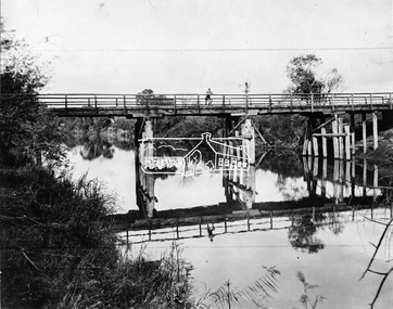
Negative - Photograph, Henley Bridge, c.1928
... This timber trestle bridge is said to have been built some time after 1907 by Melbourne master-builder, David Mitchell (the father of Dame Nellie Melba), to connect his two "Henley Farm" properties with Lilydale. In earlier days, when the McPhersons owned the property, their children used a punt to cross the river to attend Yering Primary School. This private bridge is best viewed from the end of Wendy Way...This timber trestle bridge is said to have been built some time after 1907 by Melbourne master-builder, David Mitchell (the father of Dame Nellie Melba), to connect his two "Henley Farm" properties with Lilydale. In earlier days, when the McPhersons owned the property, their children used a punt to cross the river to attend Yering Primary School. This private bridge is best viewed from the end of Wendy Way ...Situated on the Yarra River, 5.5 kms south of Christmas Hills on private property. This timber trestle bridge is said to have been built some time after 1907 by Melbourne master-builder, David Mitchell (the father of Dame Nellie Melba), to connect his two "Henley Farm" properties with Lilydale. In earlier days, when the McPhersons owned the property, their children used a punt to cross the river to attend Yering Primary School. This private bridge is best viewed from the end of Wendy Way. - Source: Christmas Hills Past and Present, Yarra Glen & District Historical Society, 2004.This photo forms part of a collection of photographs gathered by the Shire of Eltham for their centenary project book,"Pioneers and Painters: 100 years of the Shire of Eltham" by Alan Marshall (1971). The collection of over 500 images is held in partnership between Eltham District Historical Society and Yarra Plenty Regional Library (Eltham Library) and is now formally known as the 'The Shire of Eltham Pioneers Photograph Collection.' It is significant in being the first community sourced collection representing the places and people of the Shire's first one hundred years.Digital image 4 x 5 inch black and white negative 9 x 12.5 cm printshire of eltham pioneers photograph collection, warrandyte, henley bridge, reflection -
 Eltham District Historical Society Inc
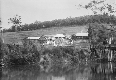
Photograph, Henley Bridge, c.1928
... This timber trestle bridge is said to have been built some time after 1907 by Melbourne master-builder, David Mitchell (the father of Dame Nellie Melba), to connect his two "Henley Farm" properties with Lilydale. In earlier days, when the McPhersons owned the property, their children used a punt to cross the river to attend Yering Primary School. This private bridge is best viewed from the end of Wendy Way...This timber trestle bridge is said to have been built some time after 1907 by Melbourne master-builder, David Mitchell (the father of Dame Nellie Melba), to connect his two "Henley Farm" properties with Lilydale. In earlier days, when the McPhersons owned the property, their children used a punt to cross the river to attend Yering Primary School. This private bridge is best viewed from the end of Wendy Way ...Situated on the Yarra River, 5.5 kms south of Christmas Hills on private property. This timber trestle bridge is said to have been built some time after 1907 by Melbourne master-builder, David Mitchell (the father of Dame Nellie Melba), to connect his two "Henley Farm" properties with Lilydale. In earlier days, when the McPhersons owned the property, their children used a punt to cross the river to attend Yering Primary School. This private bridge is best viewed from the end of Wendy Way. - Source: Christmas Hills Past and Present, Yarra Glen & District Historical Society, 2004.This photo forms part of a collection of photographs gathered by the Shire of Eltham for their centenary project book,"Pioneers and Painters: 100 years of the Shire of Eltham" by Alan Marshall (1971). The collection of over 500 images is held in partnership between Eltham District Historical Society and Yarra Plenty Regional Library (Eltham Library) and is now formally known as the 'The Shire of Eltham Pioneers Photograph Collection.' It is significant in being the first community sourced collection representing the places and people of the Shire's first one hundred years.9 x 12.5 cm printshire of eltham pioneers photograph collection, warrandyte, henley bridge -
 Eltham District Historical Society Inc
Photograph, Henley Bridge, Spring Excursion, Exploring the Upper Yarra, 22 October 1995, 22/10/1995
... This timber trestle bridge is said to have been built some time after 1907 by Melbourne master-builder, David Mitchell (the father of Dame Nellie Melba), to connect his two "Henley Farm" properties with Lilydale. In earlier days, when the McPhersons owned the property, their children used a punt to cross the river to attend Yering Primary School. This private bridge is best viewed from the end of Wendy Way...This timber trestle bridge is said to have been built some time after 1907 by Melbourne master-builder, David Mitchell (the father of Dame Nellie Melba), to connect his two "Henley Farm" properties with Lilydale. In earlier days, when the McPhersons owned the property, their children used a punt to cross the river to attend Yering Primary School. This private bridge is best viewed from the end of Wendy Way ...[article by Bettina Woodburn in EDHS Newsletter No. 105, November 1995:] EXPLORING THE UPPER YARRA - We enjoyed the Spring Excursion, this year "Exploring the Upper Yarra" - in spite of the constant rain and the countryside under the cloud cover, especially in the valleys, being mainly shiny shades of green. The occasional fields of buttercups, clumps of arum lilies and splendid rhododendron and other flowering bushes became very special. The Cobb and Co coach was warm and a cosy retreat as we zig-zagged on the highways and byways to glimpse the Yarra River, upstream and down, its secret places, and particularly the many bridges. Russell excelled as 'Poet Laureate', reading from Dacre Smyth's book. This 1979 publication includes paintings of all the bridges along the river with poems and brief descriptions of each one. Some of the bridges are in out-of-the-way places and are not very well known. We looked forward to hearing the poetry as much as seeing the 'constructions'… Big Pat (was he short or tall, lean or fat? - he did win the £200 reward for discovering gold and had the creek named after him), about the 'Eddies'?, and the disliked 'meccano' bridge in Warburton, etc. etc. The hot roast lunch in the old Reefton Hotel was also most welcome. It was easy to imagine it peopled by miners and early settlers. Starting by crossing the new (1974) concrete bridge at Warrandyte we headed through Wonga Park with views to the Christmas Hills and to the escarpment of the Yering Gorge, which causes flood waters to back up through the Yarra Glen plain, so avoiding disasters downstream. At the end of a long driveway we found the wooden, privately owned Henley Bridge (1935 after the 1934 floods). This facilitates access to different parts of Henley Farm and to Lilydale. Everard Park, named after Blanche Shallard's father, a State Member for 17 years, below the Highway Yarra crossing was in need of care. It is 10 miles from Yarra Glen by road but, as "Yarra Marra” canoeists well know, 32 winding miles down by water. After more delightful countryside scenes we joined the Warburton Highway at Woori Yallock. From the old Railway Station at Launching Place the Centennial Trail for walkers, cyclists and horse riders has replaced the rails. The line from Lilydale was opened in 1901, and the last diesel freight train ran to Warburton in 1965. It continued to rain as we had morning tea in Warburton in a shelter between footbridges. From here we continued upstream past the Bridge to O'Shannassy Lodge and Reservoir, Starvation Creek, and the Peninsular tunnel (miners dug it as at Pound Bend) which we visited (scrambling down those steps!) on our return after lunch. Our furthermost point was the Upper Yarra Dam Reserve (and vast catchment area). Finished in 1957 after ten years' work and 100 years after Yan Yean, it supplies much of Melbourne's water. After crossing the 30m Launching Place Bridge to the Eltham side of the Yarra and Healesville, we saw in the distance the Yarra Glen Timber Trestle Bridge over the river flats "the longest for years in the land it was said!" Harry's dream of "better weather over the Divide" unfortunately didn't come true, but I'm sure we 36 members will retain happy memories of a day that was wet and green and filled with Bridges. Situated on the Yarra River, 5.5 kms south of Christmas Hills on private property. This timber trestle bridge is said to have been built some time after 1907 by Melbourne master-builder, David Mitchell (the father of Dame Nellie Melba), to connect his two "Henley Farm" properties with Lilydale. In earlier days, when the McPhersons owned the property, their children used a punt to cross the river to attend Yering Primary School. This private bridge is best viewed from the end of Wendy Way. - Source: Christmas Hills Past and Present, Yarra Glen & District Historical Society, 2004.Two colour photographsactivities, henley bridge, upper yarra -
 Eltham District Historical Society Inc
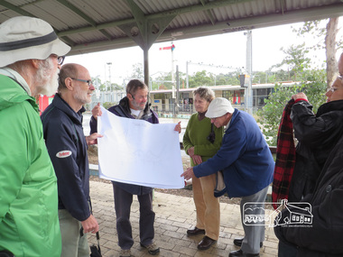
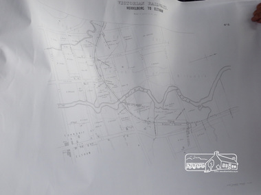
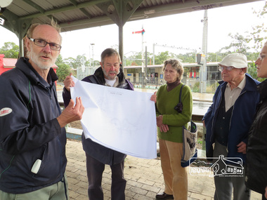
Photograph, Liz Pidgeon, Heritage Excursion; The 1901 Eltham Railway Walk, 3 May 2014, 3 May 2014
... way we will discuss the details shown on the railway plans as well as more recent railway documents and photographs. At the conclusion and if time permits we can inspect the historical display at the Eltham Station. The walk is about 3 km in length and will take about 2.5 hours. It will start at 2 pm at the Eltham Railway Station car park (east/Main Road side) (Melway Ref. 21 J5). heritage excursion activities eltham district historical society eltham railway station eltham library trestle bridge Born Digital Heritage Excursion; The 1901 Eltham Railway Walk, 3 May 2014 Photograph Liz Pidgeon ...Newsletter No. 216, May 2014 May Excursion – The 1901 Eltham Railway Walk The railway from Heidelberg to Eltham was opened in 1902. Over the previous year railway construction cut a curving swathe through Josiah Holloway’s 1851 Little Eltham subdivision. The survey plans for the railway show the owners and occupiers of land within Little Eltham affected by the railway alignment and for some distance each side. The plans show houses and other buildings but development at that time was rather sparse. Copies of these plans from the State Library of Victoria collection have been provided to the Society by Alan Sheehan. For our walk on 3rd May we intend to follow the railway from the Eltham Station to Ryans Road, which was the boundary of the adjoining Montmorency Farm. The return will be by way of nearby streets. Along the way we will discuss the details shown on the railway plans as well as more recent railway documents and photographs. At the conclusion and if time permits we can inspect the historical display at the Eltham Station. The walk is about 3 km in length and will take about 2.5 hours. It will start at 2 pm at the Eltham Railway Station car park (east/Main Road side) (Melway Ref. 21 J5).Born Digitalheritage excursion, activities, eltham district historical society, eltham railway station, eltham library, trestle bridge -
 Eltham District Historical Society Inc
Photograph, Liz Pidgeon, Heritage Excursion; The 1901 Eltham Railway Walk, 3 May 2014, 3 May 2014
... way we will discuss the details shown on the railway plans as well as more recent railway documents and photographs. At the conclusion and if time permits we can inspect the historical display at the Eltham Station. The walk is about 3 km in length and will take about 2.5 hours. It will start at 2 pm at the Eltham Railway Station car park (east/Main Road side) (Melway Ref. 21 J5). heritage excursion activities eltham district historical society eltham railway station eltham library trestle bridge Born Digital Heritage Excursion; The 1901 Eltham Railway Walk, 3 May 2014 Photograph Liz Pidgeon ...Newsletter No. 216, May 2014 May Excursion – The 1901 Eltham Railway Walk The railway from Heidelberg to Eltham was opened in 1902. Over the previous year railway construction cut a curving swathe through Josiah Holloway’s 1851 Little Eltham subdivision. The survey plans for the railway show the owners and occupiers of land within Little Eltham affected by the railway alignment and for some distance each side. The plans show houses and other buildings but development at that time was rather sparse. Copies of these plans from the State Library of Victoria collection have been provided to the Society by Alan Sheehan. For our walk on 3rd May we intend to follow the railway from the Eltham Station to Ryans Road, which was the boundary of the adjoining Montmorency Farm. The return will be by way of nearby streets. Along the way we will discuss the details shown on the railway plans as well as more recent railway documents and photographs. At the conclusion and if time permits we can inspect the historical display at the Eltham Station. The walk is about 3 km in length and will take about 2.5 hours. It will start at 2 pm at the Eltham Railway Station car park (east/Main Road side) (Melway Ref. 21 J5).Born Digitalheritage excursion, activities, eltham district historical society, eltham railway station, eltham library, trestle bridge -
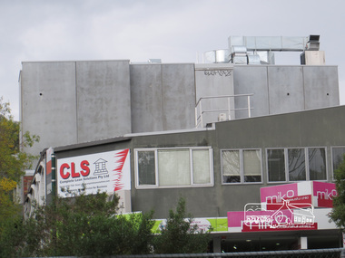
 Eltham District Historical Society Inc
Photograph, Liz Pidgeon, Heritage Excursion; The 1901 Eltham Railway Walk, 3 May 2014, 3 May 2014
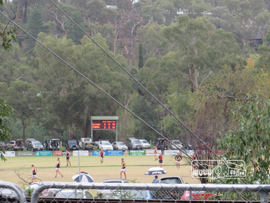
... way we will discuss the details shown on the railway plans as well as more recent railway documents and photographs. At the conclusion and if time permits we can inspect the historical display at the Eltham Station. The walk is about 3 km in length and will take about 2.5 hours. It will start at 2 pm at the Eltham Railway Station car park (east/Main Road side) (Melway Ref. 21 J5). heritage excursion activities eltham district historical society eltham railway station eltham library trestle bridge Eltham Central Park football Born Digital Heritage Excursion; The 1901 Eltham Railway Walk, 3 May 2014 Photograph Photograph Liz Pidgeon ...Football match at Eltham Central Park between Eltham and Heidelberg Newsletter No. 216, May 2014 May Excursion – The 1901 Eltham Railway Walk The railway from Heidelberg to Eltham was opened in 1902. Over the previous year railway construction cut a curving swathe through Josiah Holloway’s 1851 Little Eltham subdivision. The survey plans for the railway show the owners and occupiers of land within Little Eltham affected by the railway alignment and for some distance each side. The plans show houses and other buildings but development at that time was rather sparse. Copies of these plans from the State Library of Victoria collection have been provided to the Society by Alan Sheehan. For our walk on 3rd May we intend to follow the railway from the Eltham Station to Ryans Road, which was the boundary of the adjoining Montmorency Farm. The return will be by way of nearby streets. Along the way we will discuss the details shown on the railway plans as well as more recent railway documents and photographs. At the conclusion and if time permits we can inspect the historical display at the Eltham Station. The walk is about 3 km in length and will take about 2.5 hours. It will start at 2 pm at the Eltham Railway Station car park (east/Main Road side) (Melway Ref. 21 J5).Born Digitalheritage excursion, activities, eltham district historical society, eltham railway station, eltham library, trestle bridge, eltham central park, football