Showing 11 items matching "tullaroop creek"
-
 Clunes Museum
Photograph
... SEPIA PHOTOGRAPH OF GOVERNMENT BRIDGE OVER TULLAROOP CREEK, CLUNES....BRIDGE OVER TULLAROOP CREEK, CLUNES. PUBLISHED BY E. BARNETT, M5124 [FOR REVERSE - SEE OVER]...Clunes Museum 36 Fraser Street enter building through Collins Place Clunes goldfields local history photography photographs bridges BRIDGE OVER TULLAROOP CREEK, CLUNES. PUBLISHED BY E. BARNETT, M5124 [FOR REVERSE - SEE OVER] SEPIA PHOTOGRAPH OF GOVERNMENT BRIDGE OVER TULLAROOP CREEK, CLUNES. ...SEPIA PHOTOGRAPH OF GOVERNMENT BRIDGE OVER TULLAROOP CREEK, CLUNES.BRIDGE OVER TULLAROOP CREEK, CLUNES. PUBLISHED BY E. BARNETT, M5124 [FOR REVERSE - SEE OVER]local history, photography, photographs, bridges -
 Clunes Museum
Photograph, BAWDEN PHOTOGRAPHER, CIRCA 1890
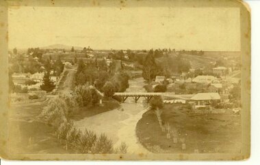
... TULLAROOP CREEK FROM "ROCKS" NEAR SITE OF PORT PHILLIP MINE. ...ORIGINAL SEPIA PHOTOGRAPH OF TULLAROOP CREEK, IN FOREGROUND VIEWS OF CLUNES TOWNSHIP. ...Clunes Museum 36 Fraser Street enter building through Collins Place Clunes goldfields TULLAROOP CREEK FROM "ROCKS" NEAR SITE OF PORT PHILLIP MINE. ...TULLAROOP CREEK FROM "ROCKS" NEAR SITE OF PORT PHILLIP MINE. ABOUT 1890 - NOTE GOVERNMENT BRIDGE IN DISTANCE. THIS WAS REBUILT IN STRAIGHT STEEL GIRDERS IN 1896.ORIGINAL SEPIA PHOTOGRAPH OF TULLAROOP CREEK, IN FOREGROUND VIEWS OF CLUNES TOWNSHIP. TWO MILE HILL IN LEFT FAR DISTANCE. (SUSPENSION BRIDGE IN FOREGROUND)local history, photography, bridges - buildings and landscape of clunes -
 Clunes Museum
Photograph
... PHOTOGRAPH OF CLUNES SHOWING TULLAROOP CREEK...Clunes Museum 36 Fraser Street enter building through Collins Place Clunes goldfields local history photography photographs clunes township TO HANNAH & DUNAL XMAS GREETINGS 1956 TOM PAYNE PHOTOGRAPH OF CLUNES SHOWING TULLAROOP CREEK Photograph PHOTOGRAPH ...PHOTOGRAPH OF CLUNES SHOWING TULLAROOP CREEKTO HANNAH & DUNAL XMAS GREETINGS 1956 TOM PAYNElocal history, photography, photographs, clunes township -
 Clunes Museum
Photograph, CIRCA 1880
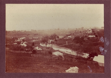
... BLACK AND WHITE PHOTOGRAPH OF THE SUSPENSION BRIDGE OVER TULLAROOP CREEK, CLUNES....BLACK AND WHITE PHOTOGRAPH OF THE SUSPENSION BRIDGE OVER TULLAROOP CREEK, CLUNES. Photograph PHOTOGRAPH ...BLACK AND WHITE PHOTOGRAPH OF THE SUSPENSION BRIDGE OVER TULLAROOP CREEK, CLUNES.CLUNES 1880.local history, photography, photographs, bridges -
 Clunes Museum
Photograph, FOOT BRIDGE, CIRCA 1920
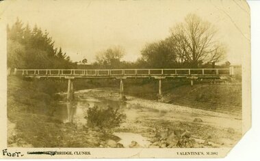
... POST CARD PHOTOGRAPH OF FOOTBRIDGE IN CLUNES OVER TULLAROOP CREEK. TAKEN ABOUT 1920....VALENTINES M 5982 POST CARD PHOTOGRAPH OF FOOTBRIDGE IN CLUNES OVER TULLAROOP CREEK. TAKEN ABOUT 1920. FOOT BRIDGE Photograph PHOTOGRAPH ...POST CARD PHOTOGRAPH OF FOOTBRIDGE IN CLUNES OVER TULLAROOP CREEK. TAKEN ABOUT 1920.FOOT BRIDGE CLUNES. VALENTINES M 5982local history, photographs, bridges, foot bridge -
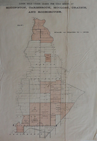 Federation University Historical Collection
Plan, Lands held under leases for gold mining at Biddington, Carisbrook, Moolort, Craigie and Rodborough, not dated
... ...Tullaroop Creek...Barker Library (top floor) Mount Helen goldfields biddington carisbrook moolort craigie rodborough mining lease d. fitzpatrick m. mullins d. fern kong meng p. mitchell curtain and co a. robertson j. fay chalk's extended Tullaroop Creek mining gold mines Bucknall's Estate Chalk's Estate Printed paper map with red shading Lands held under leases for gold mining at Biddington, Carisbrook, Moolort, Craigie and Rodborough Plan Plan ...Printed paper map with red shadingbiddington, carisbrook, moolort, craigie, rodborough, mining lease, d. fitzpatrick, m. mullins, d. fern, kong meng, p. mitchell, curtain and co, a. robertson, j. fay, chalk's extended, tullaroop creek, mining, gold mines, bucknall's estate, chalk's estate -
 Clunes Museum
Photograph, CIRCA 1880
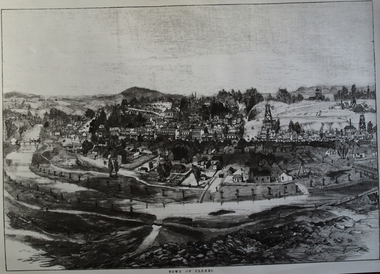
... TREE GUARDS AROUND TREES ALONG CREEK BANK, ORIGINAL NAMED TULLAROOP CREEK....TREE GUARDS AROUND TREES ALONG CREEK BANK, ORIGINAL NAMED TULLAROOP CREEK. local history photography photographs clunes township. ...AN ETCHING OF VERY EARLY CLUNES. TREE GUARDS AROUND TREES ALONG CREEK BANK, ORIGINAL NAMED TULLAROOP CREEK.CLUNES TOWNSHIP, CRESWICK CREEK, DOUBLE STORY BUILDINGS AND MINE POPPET HEADS.TOWN OF CLUNESlocal history, photography, photographs, clunes township. -
 Clunes Museum
Photograph, APPROX. 1900
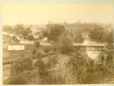
... THE PHOTOGRAPH WAS TAKEN FROM CREEK PARADE GOVERNMENT BRIDGE CRESWICK ROAD AND BUTTER FACTORY BRIDGE ACROSS TULLAROOP CREEK. GASWORKS....Clunes Museum 36 Fraser Street enter building through Collins Place Clunes goldfields THE PHOTOGRAPH WAS TAKEN FROM CREEK PARADE GOVERNMENT BRIDGE CRESWICK ROAD AND BUTTER FACTORY BRIDGE ACROSS TULLAROOP CREEK. GASWORKS. local history photography photographs bridges and buildings .1 ON BACK OF PHOTOGRAPH GASWORKS, BRIDGES AND CREEK. 1900 .3 ON FRONT OF POSTCARD GOV. ...THE PHOTOGRAPH WAS TAKEN FROM CREEK PARADE GOVERNMENT BRIDGE CRESWICK ROAD AND BUTTER FACTORY BRIDGE ACROSS TULLAROOP CREEK. GASWORKS..1 ORIGINAL SEPIA LANDSCAPE OF CLUNES MOUNTED ON CARDBOARD. GOVERNMENT AND JUBILEE BRIDGES ACROSS CRESWICK CREEK. GASWORKS NEARBY. .2 BLACK AND WHITE COPY OF THE ABOVE PHOTOGRAPH PRINTED ON GLOSS PHOTOGRAPHIC PAPER .3 HAND COLOURED POSTCARD PHOTOGRAPH OF THE ABOVE PHOTOGRAPH .4 TWO POSTCARDS WITH SAME PICTURE .5 FOUR SMALL PHOTOGRAPH COPIES WITH SAME PICTURE.1 ON BACK OF PHOTOGRAPH GASWORKS, BRIDGES AND CREEK. 1900 .3 ON FRONT OF POSTCARD GOV. BRIDGE CLUNESlocal history, photography, photographs, bridges and buildings -
 Clunes Museum
Photograph
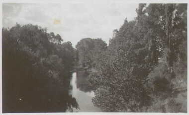
... VIEW OF THE CREEK AT CLUNES (CRESWICK CREEK - TULLAROOP)...Clunes Museum 36 Fraser Street enter building through Collins Place Clunes goldfields local history photography photographs clunes landscape THE CREEK AT CLUNES VIEW OF THE CREEK AT CLUNES (CRESWICK CREEK - TULLAROOP) Photograph PHOTOGRAPH ...VIEW OF THE CREEK AT CLUNES (CRESWICK CREEK - TULLAROOP)THE CREEK AT CLUNESlocal history, photography, photographs, clunes, landscape -
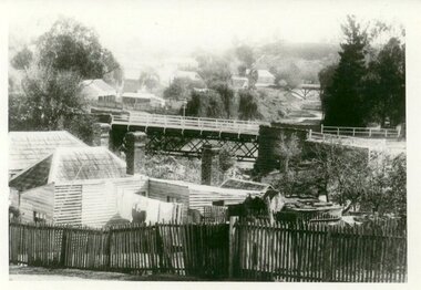 Clunes Museum
Photograph
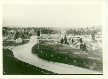
... PHOTOGRAPH TAKEN LOOKING DOWNSTREAM TULLAROOP CREEK, ABOUT 1900. GOVERNMENT BRIDGE IN FOREGROUND, JULILEE BRIDGE IN MIDDLE DISTANCE, PORT PHILLIP MINE POPPET HED IN DISTANCE....Clunes Museum 36 Fraser Street enter building through Collins Place Clunes goldfields PHOTOGRAPH TAKEN LOOKING DOWNSTREAM TULLAROOP CREEK, ABOUT 1900. GOVERNMENT BRIDGE IN FOREGROUND, JULILEE BRIDGE IN MIDDLE DISTANCE, PORT PHILLIP MINE POPPET HED IN DISTANCE. bridges JUBILEE BRIDGE GOVERMENT BRIDGE IN HANDWRITING : LOOKING DOWN-STREAM TULLAROOP CREEKABOUT 1900 GOVERMENT BRIDGE IN FOREGROUND JUBILEE BRIDGE IN THE MIDDLE .1 ORIGINAL PHOTOGRAPH OF GOVERNMENT BRIDGE AND JUBILEE BRIDGE. ...PHOTOGRAPH TAKEN LOOKING DOWNSTREAM TULLAROOP CREEK, ABOUT 1900. GOVERNMENT BRIDGE IN FOREGROUND, JULILEE BRIDGE IN MIDDLE DISTANCE, PORT PHILLIP MINE POPPET HED IN DISTANCE..1 ORIGINAL PHOTOGRAPH OF GOVERNMENT BRIDGE AND JUBILEE BRIDGE. TAKEN FROM CREEK PARADE. THE GOVERNMENT BRIDGE WAS BUILT CIRCA 1900. .2 ENLARGED PHOTOCOPY IN HANDWRITING : LOOKING DOWN-STREAM TULLAROOP CREEKABOUT 1900 GOVERMENT BRIDGE IN FOREGROUND JUBILEE BRIDGE IN THE MIDDLEbridges, jubilee bridge, goverment bridge -
 Federation University Historical Collection
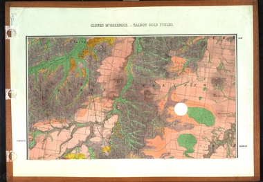
Map, Clunes, Mt Greenock, and Talbot Gold Fields, 1883, 1883
... A geological plan of the Clunes, Mt Greenock, and Talbot Gold Fields in two parts. .1) This section of the map includes Talbot, Talbot water supply race, Mt Glasgow, Little Green Hill, Middle Hill, Mt Cameron, Ballarat Hill, Bakery Hill, Goodwoman Hill, Scandanavian Lead, Eglinton Swamp, McCallum's Creek, Tullaroop Creek, Dunach, Maryborough Railway, Middle Creek and includes many mines such as Rip Van Winkel, Union Extended, South Greenock, Nicholl's Freehold. .2) This section of the map includes McCallums, Clunes, Green Hill, Mt Beckworth, Mt Gap, Maryborough Reservoir, and includes mines such as Lothair, Bute, Clyde, Clunes Consols, London and Australian, Oriental,...Barker Library (top floor) Mount Helen goldfields clunes talbot water supply railway geology A geological plan of the Clunes, Mt Greenock, and Talbot Gold Fields in two parts. .1) This section of the map includes Talbot, Talbot water supply race, Mt Glasgow, Little Green Hill, Middle Hill, Mt Cameron, Ballarat Hill, Bakery Hill, Goodwoman Hill, Scandanavian Lead, Eglinton Swamp, McCallum's Creek, Tullaroop Creek, Dunach, Maryborough Railway, Middle Creek and includes many mines such as Rip Van Winkel, Union Extended, South Greenock, Nicholl's Freehold. .2) This section of the map includes McCallums, Clunes, Green Hill, Mt Beckworth, Mt Gap, Maryborough Reservoir, and includes mines such as Lothair, Bute, Clyde, Clunes Consols, London and Australian, Oriental, Clunes, Mt Greenock, and Talbot Gold Fields, 1883 Map Map J. ...A geological plan of the Clunes, Mt Greenock, and Talbot Gold Fields in two parts. .1) This section of the map includes Talbot, Talbot water supply race, Mt Glasgow, Little Green Hill, Middle Hill, Mt Cameron, Ballarat Hill, Bakery Hill, Goodwoman Hill, Scandanavian Lead, Eglinton Swamp, McCallum's Creek, Tullaroop Creek, Dunach, Maryborough Railway, Middle Creek and includes many mines such as Rip Van Winkel, Union Extended, South Greenock, Nicholl's Freehold. .2) This section of the map includes McCallums, Clunes, Green Hill, Mt Beckworth, Mt Gap, Maryborough Reservoir, and includes mines such as Lothair, Bute, Clyde, Clunes Consols, London and Australian, Oriental,clunes, talbot, water supply, railway, geology