Showing 69 items matching "unmade street"
-
 Eltham District Historical Society Inc
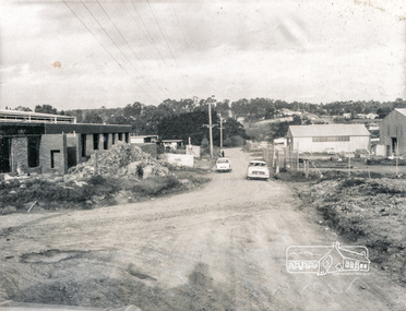
Photograph, Brisbane Street, Eltham (unmade) from west end, 1969, 1969
... Brisbane Street, Eltham (unmade) from west end, 1969...Brisbane Street, Eltham (unmade) from west end, showing light industrial area 1969...Eltham District Historical Society Inc 728 Main Rd Eltham melbourne Brisbane Street, Eltham (unmade) from west end, showing light industrial area 1969 eltham 1969 roads streets brisbane street light industrial area verso: Brisbane Street before road made 1967 looking east black and white photograph with white border Brisbane Street, Eltham (unmade) from west end, 1969 Photograph ...Brisbane Street, Eltham (unmade) from west end, showing light industrial area 1969black and white photograph with white borderverso: Brisbane Street before road made 1967 looking east eltham, 1969, roads, streets, brisbane street, light industrial area -
 Chelsea & District Historical Society Inc
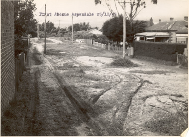
Photograph - First Avenue, Aspendale, 1949
... unmade street...First Avenue runs between Station Street and Sixth Avenue. unmade street Aspendale First Avenue Alan Niemann Drainage-Road Making Scheme Black and white photo looking east along First Avenue, Aspendale. ...This photo is one of a collection of photos taken during Alan Niemann's - Drainage-Road Making Scheme. First Avenue runs between Station Street and Sixth Avenue.Black and white photo looking east along First Avenue, Aspendale. The road us unmade and rusted with vegetation growing on the road, houses and electricity poles line both sides. unmade street, aspendale, first avenue, alan niemann, drainage-road making scheme -
 Chelsea & District Historical Society Inc
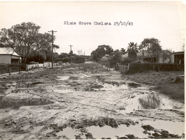
Photograph - Elsie Grove, Chelsea, 1949
... unmade street...The road is unmade and rutted with large puddles, houses line both sides and electricity poles are on the left side of the road. The photo has been taken from Station Street....Elsie Grove runs between Station Street and Randal Avenue, Chelsea. unmade street Aspendale Alan Niemann Drainage-Road Making Scheme Elsie Grove Black and white photo looking east along Elsie Grove, Chelsea. ...This photo is one of a collection of photos taken during Alan Niemann's - Drainage-Road Making Scheme. Elsie Grove runs between Station Street and Randal Avenue, Chelsea.Black and white photo looking east along Elsie Grove, Chelsea. The road is unmade and rutted with large puddles, houses line both sides and electricity poles are on the left side of the road. The photo has been taken from Station Street.unmade street, aspendale, alan niemann, drainage-road making scheme, elsie grove -
 Chelsea & District Historical Society Inc
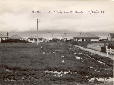
Photograph - Haig Avenue, Edithvale, 1949
... unmade street...Chelsea & District Historical Society Inc The Chelsea Activity Hub 3-5 Showers Ave Chelsea 3196 melbourne This photo is one of a collection of photos taken during Alan Niemann's - Drainage-Road Making Scheme. unmade street Aspendale Alan Niemann Drainage-Road Making Scheme Haig Avenue Edithvale Two black and white photo of the northern and southern ends of Haig Avenue, Edithvale. ...This photo is one of a collection of photos taken during Alan Niemann's - Drainage-Road Making Scheme.Two black and white photo of the northern and southern ends of Haig Avenue, Edithvale. The road is unmade with grass growing on the road, is rutted with large puddles, houses line both sides and electricity poles are both side of the road. unmade street, aspendale, alan niemann, drainage-road making scheme, haig avenue, edithvale -
 Chelsea & District Historical Society Inc
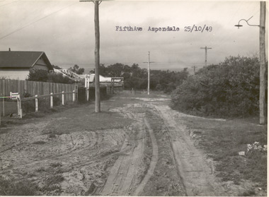
Photograph - Fifth Avenue, Aspendale, 1949
... unmade street...Chelsea & District Historical Society Inc The Chelsea Activity Hub 3-5 Showers Ave Chelsea 3196 melbourne This photo is one of a collection of photos taken during Alan Niemann's - Drainage-Road Making Scheme. unmade street Aspendale Alan Niemann Drainage-Road Making Scheme Edithvale Fifth Avenue Black and white photo of Fifth Avenue, Aspendale. ...This photo is one of a collection of photos taken during Alan Niemann's - Drainage-Road Making Scheme.Black and white photo of Fifth Avenue, Aspendale. The road is unmade with grass growing on the road, is rutted, houses can be seen on the left and electricity poles are both side of the road. unmade street, aspendale, alan niemann, drainage-road making scheme, edithvale, fifth avenue -
 Whitehorse Historical Society Inc.
Article, 30 Miles in 30 Months, 1964
... Council announced that it will spend one and a half million pounds in 30 months on 30 miles of unmade streets in the City of Nunawading....Whitehorse Historical Society Inc. 2-10 Deep Creek Road Mitcham melbourne City of Nunawading Road Construction Council announced that it will spend one and a half million pounds in 30 months on 30 miles of unmade streets in the City of Nunawading. Council announced that it will spend one and a half million pounds in 30 months on 30 miles of unmade streets in the City of Nunawading. 30 Miles in 30 Months Article Article ...Council announced that it will spend one and a half million pounds in 30 months on 30 miles of unmade streets in the City of Nunawading.Council announced that it will spend one and a half million pounds in 30 months on 30 miles of unmade streets in the City of Nunawading.Council announced that it will spend one and a half million pounds in 30 months on 30 miles of unmade streets in the City of Nunawading.city of nunawading, road construction -
 Ringwood and District Historical Society
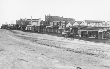
Photograph, Maroondah Highway Central, Ringwood. Shops in Main Street, 1926
... Written on rear of backing sheet: "Main St. 1926". Image shows unmade street lined with shops from Warrandyte Road to Melbourne Street. ...Written on rear of backing sheet: "Main St. 1926". Image shows unmade street lined with shops from Warrandyte Road to Melbourne Street. ...Black and white photograph (2 copies) Typed below photograph: "Maroondah Hwy. 1926. Shops now Safeway and Eastland carparks". Written on rear of backing sheet: "Main St. 1926". Image shows unmade street lined with shops from Warrandyte Road to Melbourne Street. -
 Whitehorse Historical Society Inc.
Postcard, Blackburn Road and Railway Road Blackburn C1908, 1908
... Black and white postcard entitled 'Blackburn' Scene shows corner Railway and Blackburn Roads, Albert Street unmade....Whitehorse Historical Society Inc. 2-10 Deep Creek Road Mitcham melbourne railway road blackburn hooke janet emily blackburn road blackburn albert arthur Black and white postcard entitled 'Blackburn' Scene shows corner Railway and Blackburn Roads, Albert Street unmade. Blackburn Road and Railway Road Blackburn C1908 Postcard Postcard ...Black and white postcard entitled 'Blackburn' Scene shows corner Railway and Blackburn Roads, Albert Street unmade.railway road, blackburn, hooke, janet emily, blackburn road blackburn, albert arthur -
 Phillip Island and District Historical Society Inc.
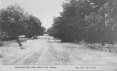
Photograph, Unmade road in Cowes
... View of a beach road, Cowes. Unmade, grassy, tree lined street....Real Photo Series M1256 View of a beach road, Cowes. Unmade, grassy, tree lined street. Unmade road in Cowes Photograph ...Part of a collection of 'Rose & Valentine' series of Post Cards. Copied by John Jansson 1984View of a beach road, Cowes. Unmade, grassy, tree lined street.Along Beach Road, Cowes, Phillip Island, Victoria. Real Photo Series M1256local history, photography, photographs, postcards, cowes, phillip island, black & white postcard copy, phillip island early roads -
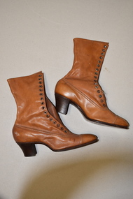 Warrnambool and District Historical Society Inc.
H. Perry & Co, Brown lace up boots x 2, 1906
... In the 19th and early 20th centuries boots were an essential item for women who often had to walk through unmade streets and muddy paddocks. ...In the 19th and early 20th centuries boots were an essential item for women who often had to walk through unmade streets and muddy paddocks. This item is of interest as it is a memento of an important New Zealand Exhibition early in the 20th century. ...These boots may have been made as a sample as they are a very small size and do not appear to have been worn. They come from the New Zealand International Exhibition held at Hagley Park, Christchurch from November 1906 to April 1907. This exhibition was the brainchild of the New Zealand Prime Minister, Richard Seddon who died before the exhibition opened. Nearly 2 million people visited the exhibition at a time when the population of New Zealand was less than one million. The exhibition was thus rated a success even though there was a financial loss. No information has been found on the bootmakers, H. Perry & Co. In the 19th and early 20th centuries boots were an essential item for women who often had to walk through unmade streets and muddy paddocks. This item is of interest as it is a memento of an important New Zealand Exhibition early in the 20th century. This is a pair of a lady’s light brown leather boots. The boots have long leather tongues with 16 eyelets either side to lace up the front instep. The laces are missing. The wooden heels are slightly raised. H. Perry & Co. New Zealand International Exhibition Christchurch 1906-7 vintage footwear, christchurch new zealand exhibition, 1906-7 -
 Eltham District Historical Society Inc
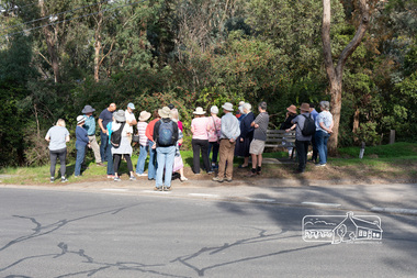
Photograph, Peter Pidgeon, Heritage Excursion: Mud Brick Meander, 6 March 2021
... They include unmade streets, steeply sloping land, extensive tree cover and a large number of mud brick and pise (rammed earth) houses. ...They include unmade streets, steeply sloping land, extensive tree cover and a large number of mud brick and pise (rammed earth) houses. ...Corner of Diamond Street and Peter Street, Eltham. Walkers gather for the beginning of the walk led by local historian Russell Yeoman. The tree-covered hill that forms the western backdrop to the Eltham town centre exhibits many characteristics that are considered to contribute to the special character of Eltham. They include unmade streets, steeply sloping land, extensive tree cover and a large number of mud brick and pise (rammed earth) houses. A number of these were constructed in the 1940s and 50s by well-known builders John Harcourt and Alistair Knox. A significant proportion from this period were constructed by owner-builders. We walked around the upper part of the hill in the area of Kerrie Crescent and Peter Street. We visited several interesting houses (for external viewing only). The walk commenced at 2pm at the corner of Diamond Street and Peter Street (Melway ref 21H4) and was about 2 km. This free walk was open to the general public as well as Society members. Whilst COVID restrictions did not require the wearing of masks in the open, masks had to be carried and all attendees registered with name and contact number or via QR registration.Born Digital (8 images)covid-19, eltham, eltham district historical society, heritage excursion, mudbrick, peter street, diamond street, russell yeoman -
Glenelg Shire Council Cultural Collection
Photograph - Photograph - Percy Street, Portland, 1970s
... Several people and horses and carts in street (unmade)....Several people and horses and carts in street (unmade). Photograph Photograph - Percy Street, Portland ...Photographic print of a rephotographed photograph. Image shows west side of Percy Street between Henty and Tyers Streets. Four single story buildings (one behind wooden fence) facing street. Robertson Store - 2 storey, round roof, far right of photo. Several people and horses and carts in street (unmade).Front: 'Robertson Store' - green inkportland street scene, percy street -
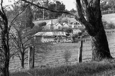 Eltham District Historical Society Inc
Photograph, George Coop, Carrucan's Dairy on Dalton Street, Eltham, c.1969, 1969
... The dairy is in the foreground situated on Dalton Street. An unmade Bible Street can be seen running down the hill at the left to intersect with Dalton Street. ...The dairy is in the foreground situated on Dalton Street. An unmade Bible Street can be seen running down the hill at the left to intersect with Dalton Street. ...Viewed from intersection of Mount Pleasant Road and Metery Road looking northwest. The dairy is in the foreground situated on Dalton Street. An unmade Bible Street can be seen running down the hill at the left to intersect with Dalton Street. Dalton Street runs from left to right between the dairy and the Carrucan family home opposite located on the southeast corner of Bible and Dalton streets. Doug Orford recalls the dairy was at a slight angle to Dalton Street. Tim Erickson, (a nephew to Betty Erickson, nee Carrucan) reacalled (9 May 2025): the bottom front paddock ran from MeteryRoad to Mount Pleasant Road The brick dairy from 1thje 1950s had 10-15 milking cow , Jersey and Guernsey6 and the used to send the cream to Eltham Dairy The garage when Tim was a child used to house a couple of sulkies The laundry was a local home built job The small house built late 1940s for Betty Carrucan for her family The small orchard grew Quince, Apple and Plum The main block was the upper paddock Cypress trees remain present as of 2025 Originally 2 buildings but a third was added in the early 1900s for a kitchen and diningDigital TIFF file Scan of 35mm Ilford HP4 black and white transparencybible street, carrucan dairy, carrucan home, dalton street, eltham, mount pleasant road -
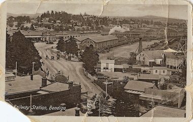 Bendigo Historical Society Inc.
Photograph - RAILWAY STATION BENDIGO, early 1900's ?
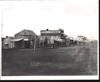
... Engine shed in centre of photo, with steam issuing from engine behind. ( not visible ) Horse and buggies in middle of street. Mitchell Street is unmade. On bottom left of card ' Railway Station, Bendigo ' On back 'Fortuna Hustlers 2240 ft ' and Mng 8, Royal Historical Society of Victoria, Bendigo Branch....Engine shed in centre of photo, with steam issuing from engine behind. ( not visible ) Horse and buggies in middle of street. Mitchell Street is unmade. On bottom left of card ' Railway Station, Bendigo ' On back 'Fortuna Hustlers 2240 ft ' and Mng 8, Royal Historical Society of Victoria, Bendigo Branch. ...sepia photo (postcard ) photo taken from elevated position on north side of Mitchell Street, of Railway Station, Bendigo. Fortuna Hustlers ( 2240 ft. ) mine on LH side of photo. Engine shed in centre of photo, with steam issuing from engine behind. ( not visible ) Horse and buggies in middle of street. Mitchell Street is unmade. On bottom left of card ' Railway Station, Bendigo ' On back 'Fortuna Hustlers 2240 ft ' and Mng 8, Royal Historical Society of Victoria, Bendigo Branch.place, landscape view, bendigo railway station -
 Bendigo Historical Society Inc.
Photograph - W. D. MASON COLLECTION: MUNDY STREET, BENDIGO 1860'S, 1860
... Clothes Cleaning & Renovating, Cahill and Associates- Obstetrician, Empire Restaurant, Dining Rooms & Boarding House, J.Lindop's Family Hotel, Allen Reeve glass, paperhanging, oil & color warehouse, John D.Bywater-Hay & Corn Dealer, Fletchers on the corner, Fosdyke Drapers.Reverse has a rubber stamp - Kilmore Historical Society .The street is unmade and no people appear to be in view -...Clothes Cleaning & Renovating, Cahill and Associates- Obstetrician, Empire Restaurant, Dining Rooms & Boarding House, J.Lindop's Family Hotel, Allen Reeve glass, paperhanging, oil & color warehouse, John D.Bywater-Hay & Corn Dealer, Fletchers on the corner, Fosdyke Drapers.Reverse has a rubber stamp - Kilmore Historical Society .The street is unmade and no people appear to be in view - Photograph W. ...Black and white Photograph Mundy Street, Bendigo, 1860s Building signs include .Professor LEWIS'S Haircutting and Shampooing Saloon, Lewis's shaving .Three Barber's poles outside the weatherboard shop. Clothes Cleaning & Renovating, Cahill and Associates- Obstetrician, Empire Restaurant, Dining Rooms & Boarding House, J.Lindop's Family Hotel, Allen Reeve glass, paperhanging, oil & color warehouse, John D.Bywater-Hay & Corn Dealer, Fletchers on the corner, Fosdyke Drapers.Reverse has a rubber stamp - Kilmore Historical Society .The street is unmade and no people appear to be in view -Batchelderphotograph, streetscape, bendigo -
 Bendigo Historical Society Inc.
Photograph - METROPOLITAN HOTEL BENDIGO, 1861 ?
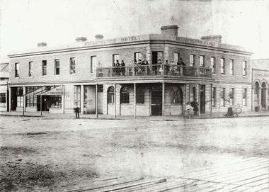
... Street and Hargreaves St., Bendigo. Also signed Metropolian Family Hotel. Two storey brick building with balcony around corner of building. Gentlemen in top hats and ladies standing on balcony. Unmade...Street and Hargreaves St., Bendigo. Also signed Metropolian Family Hotel. Two storey brick building with balcony around corner of building. Gentlemen in top hats and ladies standing on balcony. Unmade ...Black and white photo (copy). Metropolitan Hotel, Cnr. Bull Street and Hargreaves St., Bendigo. Also signed Metropolian Family Hotel. Two storey brick building with balcony around corner of building. Gentlemen in top hats and ladies standing on balcony. Unmade road in foreground. Boardwalk visible in front of photo. On LH side of building on ground floor : 'Bailes Tobacconist' sign on veranda over doorway (no roofing on verandah) Batchelder cart on RH side of photo. Photo taken in 1861. See Research field for further information.Batchelderbuildings, hotel, metropolitan hotel, metropolitan hotel. hargreaves street. bull street. batchelder, benjamin pierce. hotels. -
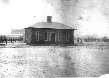
 Bendigo Historical Society Inc.
Photograph - GOVERNMENT SURVEYOR'S OFFICE: VIEW STREET, BENDIGO, late 1850's
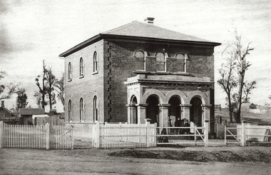
... History House 11 Mackenzie Street Bendigo goldfields ORGANIZATION Government surveyor's office black and white photo ( copy ): Brick two storey building, with three arched portico at front. Picket fence on side front of building, with railed fence at front. Road is unmade ...black and white photo ( copy ): Brick two storey building, with three arched portico at front. Picket fence on side front of building, with railed fence at front. Road is unmade. Tree to RH side of building, small brick building visible to LH side read of building.organization, government, surveyor's office -
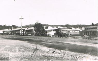
 Bendigo Historical Society Inc.
Photograph - LA TROBE UNIVERSITY BENDIGO COLLECTION: BENDIGO TEACHERS' COLLEGE
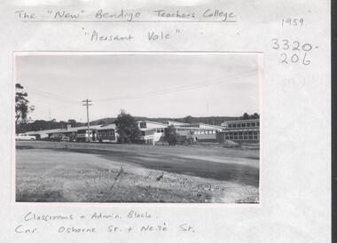
... Street Bendigo taken in 1959. It consists of classrooms and the administration block. The road appears to be unmade at this stage of the development. ...Street Bendigo taken in 1959. It consists of classrooms and the administration block. The road appears to be unmade at this stage of the development. ...A black and white photograph of the 'new' Bendigo Teachers' College on the corner of Osborne Street and Neale Street Bendigo taken in 1959. It consists of classrooms and the administration block. The road appears to be unmade at this stage of the development. See 3320.100.bendigo, education, bendigo teachers' college, la trobe university bendigo collection, collection, education, tertiary education, buildings, site, bendigo teachers' college, history, bendigo -
 Bendigo Historical Society Inc.
Photograph - LA TROBE UNIVERSITY BENDIGO COLLECTION: BENDIGO TEACHERS' COLLEGE BUILDINGS
... Street. Two A.V. Jennings signs can be seen on the side of the buildings. A Holden car is parked in front of the building. An unmade...Street. Two A.V. Jennings signs can be seen on the side of the buildings. A Holden car is parked in front of the building. An unmade ...A black and white photograph of the new Bendigo Teachers' College in Osborne Street. Two A.V. Jennings signs can be seen on the side of the buildings. A Holden car is parked in front of the building. An unmade road is in the foreground. 1959.bendigo, education, bendigo teachers' college, la trobe university bendigo collection, collection, bendigo, education, buildings, tertiary education, bendigo teachers' college, teacher training, photograph, photographs, photography -
 Bendigo Historical Society Inc.
Photograph - WATCHHOUSE: SANDHURST, 1861
... History House 11 Mackenzie Street Bendigo goldfields BUILDINGS Government watch house sandhurst batchelder Black and white reprint of Batchelder: watchhouse ( James Lerk 28.2.2000 ) , Market Square. Drays loaded with sacks both left and right. Brick building central chimney. Unmade ...Black and white reprint of Batchelder: watchhouse ( James Lerk 28.2.2000 ) , Market Square. Drays loaded with sacks both left and right. Brick building central chimney. Unmade roadway. Brick building with central arched doorway and 2 narrow windows each side of door. 1 window on Lh end of building. Contrast colour brick quoins around windows and door.batchelderbuildings, government, watch house, sandhurst -
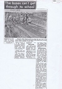 Greensborough Historical Society
Newspaper Clipping, The buses can't get through to school, 1962_
... unmade roads in the Watsonia High area. Written in 1962, this article shows the problems associated with new housing developments and lack of amenities. watsonia high school nepean street henry street In pen under title:"Zosky 1962" 1 page photocopy of news clipping. ...The Principal of Watsonia High, Mr Miller, and Parent's Association Secretary, Mrs Solum, discuss th problems of unmade roads in the Watsonia High area.Written in 1962, this article shows the problems associated with new housing developments and lack of amenities.1 page photocopy of news clipping.In pen under title:"Zosky 1962"watsonia high school, nepean street, henry street -
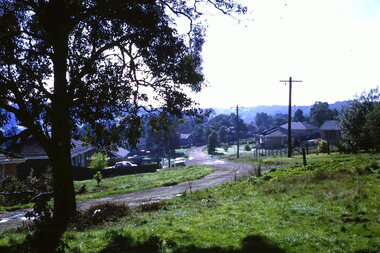 Greensborough Historical Society
Photograph - Digital Image, Turner Street from Flodden Way, 1966-1969
... Looking down Turner Street from 1 Flodden Way. Unmade road and no footpath. Fields in background beyond roof tops. ...Greensborough Historical Society 34A Glenauburn Road Lower Plenty Lower Plenty melbourne Looking down Turner Street from 1 Flodden Way. Unmade road and no footpath. Fields in background beyond roof tops. ...Looking down Turner Street from 1 Flodden Way. Unmade road and no footpath. Fields in background beyond roof tops. Cars in the driveways. The Noone family lived at 1 Flodden Way from 1966 to 1969. Caption by Julie Noone 2017.Shows the development of the area in the 1960s.Digital copy of colour photograph, taken from photographic slide.flodden way briar hill -
 Greensborough Historical Society
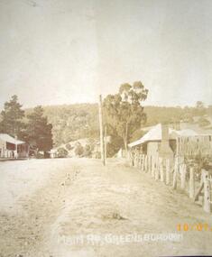
Photograph - Digital image, Main Street Greensborough, 1902
... Main Street Greensborough shown as an unmade road, circa 1910. Photographs from the collection of Peter Blackbourn, a descendant of the Chapman Stock family. ...Greensborough Historical Society 34A Glenauburn Road Lower Plenty Lower Plenty melbourne Main Street Greensborough shown as an unmade road, circa 1910. Photographs from the collection of Peter Blackbourn, a descendant of the Chapman Stock family. ...Main Street Greensborough shown as an unmade road, circa 1910. Photographs from the collection of Peter Blackbourn, a descendant of the Chapman Stock family. Annotations to photos by Peter Blackbourn.Digital copy of black and white photograph.peter blackbourn, main street greensborough -
 Greensborough Historical Society
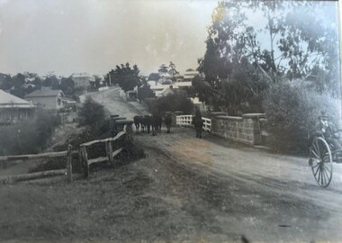
Photograph - Photograph (Framed), Herding stock over blue stone bridge looking up Main Street Greensborough
... Street Greensborough. In this photograph, Greensborough was a country town. Note the unmade road leading up to the bridge....Street Greensborough. In this photograph, Greensborough was a country town. Note the unmade road leading up to the bridge. ...Heading stock over Blue stone bridge looking up Main Street Greensborough. In this photograph, Greensborough was a country town. Note the unmade road leading up to the bridge.From the John Mackey collection. This item was displayed at the offices of Ryan, Mackey and Kelly, solicitors, Main Street Greensborough.Timber-framed photograph of herding stock over blue stone bridge looking up Main Street Greensborough, black and white.greensborough, john mackey, blue stone bridge, marble hall -
 Phillip Island and District Historical Society Inc.
Photograph - Post Card, Cowes School Back to 1926 Chapel Street, March 1926
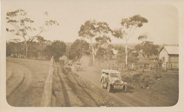
... Sepia postcard of four cars , decorated with streamers, driving along Chapel Street going west on unmade road. Land on left was owned by Methodist Church, corner of Chapel and Bass Ave., where large tree denotes the boundary. ...Phillip Island and District Historical Society Inc. phillip-island-and-the-bass-coast Donated by Stan McFee from the Keith McIlwraith Collection celebrations - back to cowes school phillip island decorated cars phillip island stan mcfee keith mcilwraith collection On back: "Back to Cowes March 1926" Sepia postcard of four cars , decorated with streamers, driving along Chapel Street going west on unmade road. Land on left was owned by Methodist Church, corner of Chapel and Bass Ave., where large tree denotes the boundary. ...Donated by Stan McFee from the Keith McIlwraith CollectionSepia postcard of four cars , decorated with streamers, driving along Chapel Street going west on unmade road. Land on left was owned by Methodist Church, corner of Chapel and Bass Ave., where large tree denotes the boundary. Finley? Forrest's house on right. Coming to Back to Cowes School Celebration March 1926On back: "Back to Cowes March 1926"celebrations - back to cowes school phillip island, decorated cars, phillip island, stan mcfee, keith mcilwraith collection -
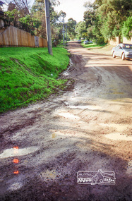
 Eltham District Historical Society Inc
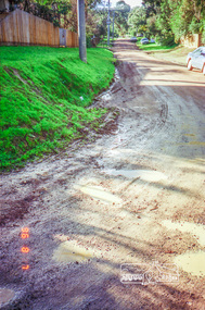
Photograph, Road surface conditions around Eltham: Looking east along Franklin Street adjacent to No. 131, 7 Aug 1996, 1996
... Shows sections of Franklin, John and Napoleon streets were still unmade as of late 1996 and the condition of those roads with potholes at the intersections with Bible Street....Eltham District Historical Society Inc 728 Main Rd Eltham melbourne Shows sections of Franklin, John and Napoleon streets were still unmade as of late 1996 and the condition of those roads with potholes at the intersections with Bible Street. ...Shows sections of Franklin, John and Napoleon streets were still unmade as of late 1996 and the condition of those roads with potholes at the intersections with Bible Street.Reflects on the changing nature of the local street-scape and housesRoll of 35mm colour negative film, 7 stripsKodak Gold 100-5eltham, napoleon street, bible street, franklin street, john street -
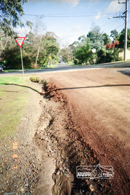
 Eltham District Historical Society Inc
Photograph, Road surface conditions around Eltham: Looking east along Franklin Street from intersection with Bible Street, 7 Aug 1996, 1996
... Shows sections of Franklin, John and Napoleon streets were still unmade as of late 1996 and the condition of those roads with potholes at the intersections with Bible Street....Eltham District Historical Society Inc 728 Main Rd Eltham melbourne Shows sections of Franklin, John and Napoleon streets were still unmade as of late 1996 and the condition of those roads with potholes at the intersections with Bible Street. ...Shows sections of Franklin, John and Napoleon streets were still unmade as of late 1996 and the condition of those roads with potholes at the intersections with Bible Street.Reflects on the changing nature of the local street-scape and housesRoll of 35mm colour negative film, 7 stripsKodak Gold 100-5eltham, napoleon street, bible street, franklin street, john street -
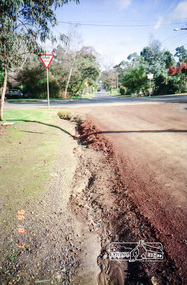
 Eltham District Historical Society Inc
Photograph, Road surface conditions around Eltham: Looking west along Franklin Street at intersection with Bible Street, 7 Aug 1996, 1996
... Shows sections of Franklin, John and Napoleon streets were still unmade as of late 1996 and the condition of those roads with potholes at the intersections with Bible Street....Eltham District Historical Society Inc 728 Main Rd Eltham melbourne Shows sections of Franklin, John and Napoleon streets were still unmade as of late 1996 and the condition of those roads with potholes at the intersections with Bible Street. ...Shows sections of Franklin, John and Napoleon streets were still unmade as of late 1996 and the condition of those roads with potholes at the intersections with Bible Street.Reflects on the changing nature of the local street-scape and housesRoll of 35mm colour negative film, 7 stripsKodak Gold 100-5eltham, napoleon street, bible street, franklin street, john street -
 Eltham District Historical Society Inc
Photograph, Road surface conditions around Eltham: Looking west along Franklin Street at intersection with Bible Street, 7 Aug 1996, 1996
... Shows sections of Franklin, John and Napoleon streets were still unmade as of late 1996 and the condition of those roads with potholes at the intersections with Bible Street....Eltham District Historical Society Inc 728 Main Rd Eltham melbourne Shows sections of Franklin, John and Napoleon streets were still unmade as of late 1996 and the condition of those roads with potholes at the intersections with Bible Street. ...Shows sections of Franklin, John and Napoleon streets were still unmade as of late 1996 and the condition of those roads with potholes at the intersections with Bible Street.Reflects on the changing nature of the local street-scape and housesRoll of 35mm colour negative film, 7 stripsKodak Gold 100-5eltham, napoleon street, bible street, franklin street, john street