Showing 5 items matching "upper yarra valley (vic.)"
-
 Narre Warren and District Family History Group
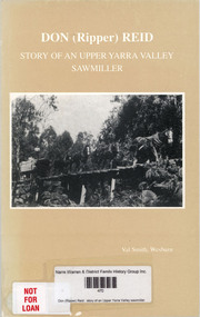
Book, Val Smith, Don (Ripper) Reid : story of an Upper Yarra Valley sawmiller, 1997
... Upper Yarra Valley (Vic.)...Narre Warren and District Family History Group 110 High Street Berwick melbourne Upper Yarra Valley (Vic.) Don Reid Donald Ambrose Reid Prior to 1901 the men working in the forests of the Upper Yarra Valley were mainly paling splitters and shingle cutters. ...Prior to 1901 the men working in the forests of the Upper Yarra Valley were mainly paling splitters and shingle cutters. When the Warburton-Lilydale Railway was completed in 1901, sawmilling became a major industry and one of the main employers in the Upper Yarra Valley. The railway enabled the sawmillers to get their timber to the Melbourne markets easily and economically. The mills were built, usually in the allotted logging area. Tramlines were used to bring timber from the mills to the railway. In the Upper Yarra Valley the tramlines were mostly horse drawn, or if it was too steep a combination of winches for lowering and then horse to complete the journey. Steam locomotives were used on the Powelltown to Yarra Junction tramline and Ezard-Richards' tramline at Starvation Creek. Donald Ambrose Reid has been a son, brother, husband, father, grandfather, Shire Councillor, firefighter and friend but through it all a Sawmiller. This is Don Reid's story. A story of a sawmilling family. Don's memories also give an insight into the early history of Upper Yarra Valley and the changes that occurred in the sawmilling and logging industry. VAL SMITH 1996/97.non-fictionPrior to 1901 the men working in the forests of the Upper Yarra Valley were mainly paling splitters and shingle cutters. When the Warburton-Lilydale Railway was completed in 1901, sawmilling became a major industry and one of the main employers in the Upper Yarra Valley. The railway enabled the sawmillers to get their timber to the Melbourne markets easily and economically. The mills were built, usually in the allotted logging area. Tramlines were used to bring timber from the mills to the railway. In the Upper Yarra Valley the tramlines were mostly horse drawn, or if it was too steep a combination of winches for lowering and then horse to complete the journey. Steam locomotives were used on the Powelltown to Yarra Junction tramline and Ezard-Richards' tramline at Starvation Creek. Donald Ambrose Reid has been a son, brother, husband, father, grandfather, Shire Councillor, firefighter and friend but through it all a Sawmiller. This is Don Reid's story. A story of a sawmilling family. Don's memories also give an insight into the early history of Upper Yarra Valley and the changes that occurred in the sawmilling and logging industry. VAL SMITH 1996/97.upper yarra valley (vic.), don reid, donald ambrose reid -
 Marysville & District Historical Society
Book, Education Department of Victoria, Vision and Realisation-A Centenary History of State Education in Victoria-Volume 3, 1973
... Marysville & District Historical Society 39 Darwin Street Marysville yarra-valley-and-the-dandenong-ranges Histories of schools in the regions of Port Phillip Western, Port Phillip Eastern, Upper Goulburn, Goulburn, Upper Murray, East Gippsland, West Gippsland. education state education victoria history port phillip western port phillip eastern upper goulburn goulburn upper murray east gippsland west gippsland A centenary history of state education in Victoria. CANCELLED stamp Stamp / CAE / LIBRARY / Class No. 379.945 / VIC ...A centenary history of state education in Victoria.Red cover with the title and volume written on the spine in gold lettering. Both front and back inside covers have a photograph of 'The school at Drummond North' Photo: Geoff Mauger non-fictionA centenary history of state education in Victoria.education, state education, victoria, history, port phillip western, port phillip eastern, upper goulburn, goulburn, upper murray, east gippsland, west gippsland -
 Koorie Heritage Trust
Book, Barraclough, Linda et al, A valley of glens : the people and places of the Upper Macalister River, 1988
... Koorie Heritage Trust Levels 1 & 3, Yarra Building Federation Square, Melbourne melbourne Upper Macalister River -- East Gippsland-History Contents: Exploration & the Heyfield run; Glenmaggie, Glenfalloch & Glencairn; Gold & the first farms; The town begins; The farms are established; Selection to the limits; Fire, flood, drought, rabbits & other forms of pestilence; The second exploration; The weir is built; A time of change; Today & tomorrow. ix, 177 p. : ill. ; index; footnotes; sources; 25 cm. A valley of glens : the people and places of the Upper Macalister River. Book Barraclough, Linda Rev. 2nd ed -- Bairnsdale, Vic ...Contents: Exploration & the Heyfield run; Glenmaggie, Glenfalloch & Glencairn; Gold & the first farms; The town begins; The farms are established; Selection to the limits; Fire, flood, drought, rabbits & other forms of pestilence; The second exploration; The weir is built; A time of change; Today & tomorrow.ix, 177 p. : ill. ; index; footnotes; sources; 25 cm.Contents: Exploration & the Heyfield run; Glenmaggie, Glenfalloch & Glencairn; Gold & the first farms; The town begins; The farms are established; Selection to the limits; Fire, flood, drought, rabbits & other forms of pestilence; The second exploration; The weir is built; A time of change; Today & tomorrow.upper macalister river -- east gippsland-history -
 Kew Historical Society Inc
Photograph - Yarra in Flood from Willsmere, North Kew, 1923
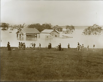
... Yarra Valley, including that section of the Yarra bordering Kew and Kew East in the north and west of the municipality, was a regular occurrence. Extreme flood events of the Yarra River are recorded to have occurred in 1891, 1901, 1916, 1923 and 1934. The Municipality of Kew's response to these floods was to enact planning decisions restricting residential development in flood prone areas following the floods of 1916, 1921, and 1934. While floods continued after the development of the Upper Yarra Reservoir (construction 1948-57), the regularity and extent of these inundations diminished. yarra river valley Kew East (vic ...Flooding of the Yarra Valley, including that section of the Yarra bordering Kew and Kew East in the north and west of the municipality, was a regular occurrence. Extreme flood events of the Yarra River are recorded to have occurred in 1891, 1901, 1916, 1923 and 1934. The Municipality of Kew's response to these floods was to enact planning decisions restricting residential development in flood prone areas following the floods of 1916, 1921, and 1934. While floods continued after the development of the Upper Yarra Reservoir (construction 1948-57), the regularity and extent of these inundations diminished. Original, large sepia photograph showing men, women and children who have gathered on a grassy verge, probably farm land, to look out across the flooded Yarra Valley at Willsmere, North Kew. In the medium distance are three houses that are largely submerged by the flood waters as well as a number of Eucalypts. Inscribed reverse: "Gift of Kerrie Woollard (KCC) (P)C.1923yarra river valley, kew east (vic.), floods, willsmere -
 Kew Historical Society Inc
Photograph - River Yarra in Flood from Kilby Road
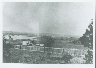
... Yarra Valley, including that section of the Yarra bordering Kew and Kew East in the north and west of the municipality, was a regular occurrence. Extreme flood events of the Yarra River are recorded to have occurred in 1891, 1901, 1916, 1923 and 1934. The Municipality of Kew's response to these floods was to enact planning decisions restricting residential development in flood prone areas following the floods of 1916, 1921 and 1934. While floods continued after the development of the Upper Yarra Reservoir (construction 1948-57), the regularity and extent of these inundations diminished. Kilby Road Floods -- Kew (Vic ...Flooding of the Yarra Valley, including that section of the Yarra bordering Kew and Kew East in the north and west of the municipality, was a regular occurrence. Extreme flood events of the Yarra River are recorded to have occurred in 1891, 1901, 1916, 1923 and 1934. The Municipality of Kew's response to these floods was to enact planning decisions restricting residential development in flood prone areas following the floods of 1916, 1921 and 1934. While floods continued after the development of the Upper Yarra Reservoir (construction 1948-57), the regularity and extent of these inundations diminished.Print copy of an original photo of the River Yarra in Flood, taken from Kilby Road.VIEW ACROSS YARRA IN FLOOD / FROM KILBY RD KEWkilby road, floods -- kew (vic.), kilby farm