Showing 85 items matching "urban conservation study"
-
 Camberwell Historical Society
Ephemera - Objects, John Niemann et al, Camberwell Urban Conservation Study, 1989-1992
... Camberwell Urban Conservation Study......Urban Conservation Study...Letters re: Urban Conservation Study with map, Conserving Camberwell questionnaire, Urban Conservation Study booklet, and City of Camberwell map...Camberwell Historical Society 25 Inglesby Road Camberwell melbourne Camberwell Urban Conservation Study Letters re: Urban Conservation Study with map, Conserving Camberwell questionnaire, Urban Conservation Study booklet, and City of Camberwell map Camberwell Urban Conservation Study Ephemera Objects John Niemann City of Camberwell ...Letters re: Urban Conservation Study with map, Conserving Camberwell questionnaire, Urban Conservation Study booklet, and City of Camberwell mapcamberwell, urban conservation study -
Camberwell Historical Society
Pamphlet (Item) - Flier, Australian Institute of Genealogical Studies Inc, Camberwell Urban Conservation Study now available for purchase
... Camberwell Urban Conservation Study now available for purchase...Flier informing that the Camberwell Urban Conservation Study, written by Dr Chris McConville and Graeme Butler in the form of a five volume report, is available for purchase....Camberwell Urban Conservation Study now available for purchase Pamphlet Flier Australian Institute of Genealogical Studies Inc. ...camberwell, urban conversation study -
Canterbury History Group
Document - "Mirabella" 62 Wattle Valley Road, 1986: P. Sanders P/L & Graeme Butler, 1991: Dr Chris McConville & Graeme Butler, 1991
... City of Camberwell Urban Conservation Study...City of Camberwell Urban Conservation Study 1986, 1991 report on "Mirabella" 62 Wattle Valley Road Canterbury....Canterbury History Group 190A Canterbury Road Canterbury melbourne Canterbury Wattle Valley Road Zelman> Victor A Gordon Garrett & Co Historic Buildings Register Historic Buildings P.Sanders P/L Butler> Graeme McConville> Chris (Dr) National Trust Of Australia City of Camberwell Urban Conservation Study City of Camberwell Urban Conservation Study 1986, 1991 report on "Mirabella" 62 Wattle Valley Road Canterbury. ...City of Camberwell Urban Conservation Study 1986, 1991 report on "Mirabella" 62 Wattle Valley Road Canterbury.canterbury, wattle valley road, zelman> victor a, gordon garrett & co, historic buildings register, historic buildings, p.sanders p/l, butler> graeme, mcconville> chris (dr), national trust of australia, city of camberwell urban conservation study -
Kew Historical Society Inc
Book, Pru Sanderson Design Pty Ltd, City of Kew Urban Conservation Study Volume 1, 1988
... City of Kew Urban Conservation Study Volume 1....) -- 1988 City of Kew Urban Conservation Study Volume 1 Book Pru Sanderson Design Pty Ltd ...non-fictionconservation reports -- kew (vic.) -- 1988 -
Kew Historical Society Inc
Book, Pru Sanderson Design Pty Ltd, City of Kew Urban Conservation Study Volume 2, 1988
... City of Kew Urban Conservation Study Volume 2....) -- 1988 City of Kew Urban Conservation Study Volume 2 Book Pru Sanderson Design Pty Ltd ...non-fictionconservation reports -- kew (vic.) -- 1988 -
Kew Historical Society Inc
Book, Pru Sanderson Design Pty Ltd, City of Kew Urban Conservation Study Volume 4, 1988
... City of Kew Urban Conservation Study Volume 4....) -- 1988 City of Kew Urban Conservation Study Volume 4 Book Pru Sanderson Design Pty Ltd ...non-fictionconservation reports -- kew (vic.) -- 1988 -
Kew Historical Society Inc
Archive (Sub-series) - Subject File, Conservation Study (Kew) 1984-88, 984
... city of kew urban conservation study...Archive file containing information about the nationally-funded Kew Urban Conservation Study, conducted by Pru Sanderson and completed in 1988. ...Typically files will contain primary and secondary sources. conservation studies -- kew(vic.) pru sanderson city of kew urban conservation study Archive file containing information about the nationally-funded Kew Urban Conservation Study, conducted by Pru Sanderson and completed in 1988. ...Various partiesReference, Research, InformationSecondary Values (KHS Imposed Order)Subject file containing information about the nationally-funded Kew Urban Conservation Study, conducted by Pru Sanderson and completed in 1988. The Society had two representatives on the Kew Heritage Committee, which was established by Council to oversee the project. The file contains a number of documents including a copy of the original submission of May 1984. Two bound copies of the completed report in three volumes are held in the Society’s library.conservation studies -- kew(vic.), pru sanderson, city of kew urban conservation studyconservation studies -- kew(vic.), pru sanderson, city of kew urban conservation study -
 Bendigo Historical Society Inc.
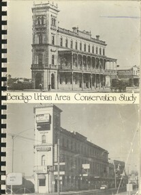
Book - BENDIGO URBAN AREA CONSERVATION STUDY, 1977
... BENDIGO URBAN AREA CONSERVATION STUDY...History House 11 Mackenzie Street Bendigo goldfields BENDIGO Buildings conservation study conservation planning schemes architecture heritage houses Lawrie Wilson & Associates Bendigo Area Conservation Study - 192 pages with photos, illustrations and maps. Written on front page ' 133 Mackenzie Street, Bendigo. Indecipherable signature with 'Bendigo, presented to RHSV Bendigo 1978'. 255pp. Book BENDIGO URBAN ...Bendigo Area Conservation Study - 192 pages with photos, illustrations and maps. Written on front page ' 133 Mackenzie Street, Bendigo. Indecipherable signature with 'Bendigo, presented to RHSV Bendigo 1978'. 255pp.Lawrie Wilson & Associatesbendigo, buildings, conservation study, conservation, planning schemes, architecture, heritage houses -
 Kew Historical Society Inc
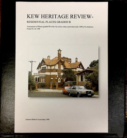
Archive (Sub-series) - Subject File, Kew Heritage Review, Residential Places Graded B, Volume 1, 1999, 1999
... The Kew Urban Conservation Study was commissioned by the City of Kew, and submitted by Pru Sanderson Design Pty Ltd in 1988. ...Black 4-Ring binder that includes research about, and an assessment of buildings previously graded B in the City of Kew Urban Conservation Study 1988 by Pru Sanderson Design Pty Ltd. ...Kew Historical Society Inc Kew Court House 188 High Street Kew melbourne The Kew Urban Conservation Study was commissioned by the City of Kew, and submitted by Pru Sanderson Design Pty Ltd in 1988. ...Graeme Butler & AssociatesProject FilesProvenance OrderBlack 4-Ring binder that includes research about, and an assessment of buildings previously graded B in the City of Kew Urban Conservation Study 1988 by Pru Sanderson Design Pty Ltd. The files were created by the heritage architect Graeme Butler and the paper files include maps, correspondence, title searches, readings, reviews of prior classifications, newspaper and journal articles, directories etc for each property assessed.graeme butler, heritage reviews - kew, 20 yarra street, 8 yarra street, 33 wills street, 25 wellington street, 11 wellington street, 118 walpole street, 84 walpole street, 83 walpole street, 63 walpole street, 52 walpole street, 51 walpole street, 14 vista avenue, 12 tara avenue, 89 studley park road, 75 studley park road, 44 studley park road, 25 studley park road, 13 studley avenue, 21 stoke avenue, 71 stevenson street, 34 stevenson street, 12 stevenson street, 36 stawell street, 11 second avenue, 3 second avenue, 2 second avenue, 34 rowland street, 21 redmond street, 11 redmond street, 16 queen street, 27 princess street, 82 molesworth street, 28 miller grove, 26 miller grove, 24 miller grove, 24 milfay avenue, 8 milfay avenue, 4 merrion grove, 25 mary street, 24 lister avenue, 2 john street, 9 hume street, 7 hume street, 24 howard street, 20 howard street, 19 howard street, 10 howard street, 2 howard street, 26 holroyd street, 12 holroyd street, 73 high street, 69 high street, 35 high street, 6 high street, 53 harp road, 6 gellibrand street, 48 foley street, 9 eglinton street, 25-27 edgecombe street, 21-23 edgecombe street, 5-7 edgecombe street, 23 dunlop avenue, 167 derby street, 8 denmark street, 1 denmark street, 2 daracomb avenue, 2 danielle place, 340 cotham road, 294 cotham road, 241 cotham road, 221-229 cotham road, 208 cotham road, 193 cotham road, 180 cotham road, 171 cotham road, 167 cotham road, 161 cotham road, 135-137 cotham road, 46 clyde street, 4 cameron court, 1291 burke road, 1223 burke road, 1205 burke road, 5 bowen street, 35-37 belford road, 389 barkers road, 387 barkers road, 311 barkers road, 231 barkers road, 83-85 barkers road, 15 adeney avenue, 6 a'beckett streetgraeme butler, heritage reviews - kew, 20 yarra street, 8 yarra street, 33 wills street, 25 wellington street, 11 wellington street, 118 walpole street, 84 walpole street, 83 walpole street, 63 walpole street, 52 walpole street, 51 walpole street, 14 vista avenue, 12 tara avenue, 89 studley park road, 75 studley park road, 44 studley park road, 25 studley park road, 13 studley avenue, 21 stoke avenue, 71 stevenson street, 34 stevenson street, 12 stevenson street, 36 stawell street, 11 second avenue, 3 second avenue, 2 second avenue, 34 rowland street, 21 redmond street, 11 redmond street, 16 queen street, 27 princess street, 82 molesworth street, 28 miller grove, 26 miller grove, 24 miller grove, 24 milfay avenue, 8 milfay avenue, 4 merrion grove, 25 mary street, 24 lister avenue, 2 john street, 9 hume street, 7 hume street, 24 howard street, 20 howard street, 19 howard street, 10 howard street, 2 howard street, 26 holroyd street, 12 holroyd street, 73 high street, 69 high street, 35 high street, 6 high street, 53 harp road, 6 gellibrand street, 48 foley street, 9 eglinton street, 25-27 edgecombe street, 21-23 edgecombe street, 5-7 edgecombe street, 23 dunlop avenue, 167 derby street, 8 denmark street, 1 denmark street, 2 daracomb avenue, 2 danielle place, 340 cotham road, 294 cotham road, 241 cotham road, 221-229 cotham road, 208 cotham road, 193 cotham road, 180 cotham road, 171 cotham road, 167 cotham road, 161 cotham road, 135-137 cotham road, 46 clyde street, 4 cameron court, 1291 burke road, 1223 burke road, 1205 burke road, 5 bowen street, 35-37 belford road, 389 barkers road, 387 barkers road, 311 barkers road, 231 barkers road, 83-85 barkers road, 15 adeney avenue, 6 a'beckett street -
 Kew Historical Society Inc
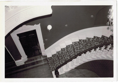
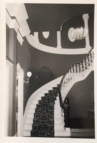
Photograph - 'Butleigh Wooton', 867 Glenferrie Road, John T Collins, 1979
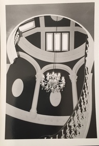
... City of Kew Urban Conservation Study Vol 2)...City of Kew Urban Conservation Study Vol 2)...City of Kew Urban Conservation Study Vol 2) thomas maidment butleigh wooton 867 glenferrie road -- kew (vic.) ...in 1882 Thomas Maidment paid the Society of Jesus £5,750 for nine allotments along Barkly Road (now Glenferrie Road). Maidment, who had arrived in Australia from the Glastonbury district in England in 1858, owned and managed a number of sheep stations in Victoria and subsequently became an '... eminently respectable ...' member of District society. In 1883 the Rate Books list Maidment's land in Barkly Road as the 'Buxton Hill Estate' and it was given an N.A.V. of £90, while in the following year his property attracted an N.A.V. of £160, suggesting that substantial improvements were taking place. Maidment's two-storey mansion, named 'Butleigh Wooton' after his birth-place in England, was completed in 1885 and was given an initial N.A.V. of £420. While Maidrnent is recorded as the owner of the building until at least 1896, Jane Maidment, his wife, continued the family ownership of the twenty-six roomed house with its extensive grounds until at least 1910. (Sanderson P. City of Kew Urban Conservation Study Vol 2)Butleigh Wooton is a substantial two storeyed house built in the Italianate style common in the 1880s. Its walls are rendered and it has limited applied decoration that includes brackets to the eaves line and engaged ionic columns under a broken pediment over the front entrance. The bowed window unit is of particular distinction and is not at all typical of this type of building. This interior by John T Collins is a view of the staircase from the first floor landing. (Sanderson P. City of Kew Urban Conservation Study Vol 2)Reverse: "JOHN COLLINS / 11 Anderson Road / Hawthorn East, 3123 / Film 395 Exposure 27A / Kew / Butleigh Wooton / Looking down on stairs / 8-4-79thomas maidment, butleigh wooton, 867 glenferrie road -- kew (vic.) -
 Kew Historical Society Inc
Photograph - 'Butleigh Wooton', 867 Glenferrie Road, John T Collins, 1979
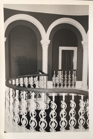
... City of Kew Urban Conservation Study Vol 2)...City of Kew Urban Conservation Study Vol 2)...City of Kew Urban Conservation Study Vol 2) thomas maidment butleigh wooton 867 glenferrie road -- kew (vic.) ...in 1882 Thomas Maidment paid the Society of Jesus £5,750 for nine allotments along Barkly Road (now Glenferrie Road). Maidment, who had arrived in Australia from the Glastonbury district in England in 1858, owned and managed a number of sheep stations in Victoria and subsequently became an '... eminently respectable ...' member of District society. In 1883 the Rate Books list Maidment's land in Barkly Road as the 'Buxton Hill Estate' and it was given an N.A.V. of £90, while in the following year his property attracted an N.A.V. of £160, suggesting that substantial improvements were taking place. Maidment's two-storey mansion, named 'Butleigh Wooton' after his birth-place in England, was completed in 1885 and was given an initial N.A.V. of £420. While Maidrnent is recorded as the owner of the building until at least 1896, Jane Maidment, his wife, continued the family ownership of the twenty-six roomed house with its extensive grounds until at least 1910. (Sanderson P. City of Kew Urban Conservation Study Vol 2)Butleigh Wooton is a substantial two storeyed house built in the Italianate style common in the 1880s. Its walls are rendered and it has limited applied decoration that includes brackets to the eaves line and engaged ionic columns under a broken pediment over the front entrance. The bowed window unit is of particular distinction and is not at all typical of this type of building. This interior by John T Collins is a view of the staircase from the first floor landing. (Sanderson P. City of Kew Urban Conservation Study Vol 2)Reverse: "JOHN COLLINS / 11 Anderson Road / Hawthorn East, 3123 / Film 395 Exposure 21A / Kew / Butleigh Wooton / Staircase / 8-4-79thomas maidment, butleigh wooton, 867 glenferrie road -- kew (vic.), john t collins -
 Kew Historical Society Inc
Photograph - 'Butleigh Wooton', 867 Glenferrie Road, John T Collins, 1979
... City of Kew Urban Conservation Study Vol 2)...City of Kew Urban Conservation Study Vol 2)...City of Kew Urban Conservation Study Vol 2) Photograph 'Butleigh Wooton', 867 Glenferrie Road John T Collins ...in 1882 Thomas Maidment paid the Society of Jesus £5,750 for nine allotments along Barkly Road (now Glenferrie Road). Maidment, who had arrived in Australia from the Glastonbury district in England in 1858, owned and managed a number of sheep stations in Victoria and subsequently became an '... eminently respectable ...' member of District society. In 1883 the Rate Books list Maidment's land in Barkly Road as the 'Buxton Hill Estate' and it was given an N.A.V. of £90, while in the following year his property attracted an N.A.V. of £160, suggesting that substantial improvements were taking place. Maidment's two-storey mansion, named 'Butleigh Wooton' after his birth-place in England, was completed in 1885 and was given an initial N.A.V. of £420. While Maidrnent is recorded as the owner of the building until at least 1896, Jane Maidment, his wife, continued the family ownership of the twenty-six roomed house with its extensive grounds until at least 1910. (Sanderson P. City of Kew Urban Conservation Study Vol 2)Butleigh Wooton is a substantial two storeyed house built in the Italianate style common in the 1880s. Its walls are rendered and it has limited applied decoration that includes brackets to the eaves line and engaged ionic columns under a broken pediment over the front entrance. The bowed window unit is of particular distinction and is not at all typical of this type of building. This interior by John T Collins is a view of the staircase from the first floor landing. (Sanderson P. City of Kew Urban Conservation Study Vol 2)Reverse: "JOHN COLLINS / 11 Anderson Road / Hawthorn East, 3123 / Film 395 Exposure 21A / Kew / Butleigh Wooton / Staircase looking up to dome / 8-4-79thomas maidment, butleigh wooton, 867 glenferrie road -- kew (vic.), john t collins -
 Kew Historical Society Inc
Photograph - 'Butleigh Wooton', 867 Glenferrie Road, John T Collins, 1979
... City of Kew Urban Conservation Study Vol 2)...City of Kew Urban Conservation Study Vol 2)...City of Kew Urban Conservation Study Vol 2) Photograph 'Butleigh Wooton', 867 Glenferrie Road John T Collins ...in 1882 Thomas Maidment paid the Society of Jesus £5,750 for nine allotments along Barkly Road (now Glenferrie Road). Maidment, who had arrived in Australia from the Glastonbury district in England in 1858, owned and managed a number of sheep stations in Victoria and subsequently became an '... eminently respectable ...' member of District society. In 1883 the Rate Books list Maidment's land in Barkly Road as the 'Buxton Hill Estate' and it was given an N.A.V. of £90, while in the following year his property attracted an N.A.V. of £160, suggesting that substantial improvements were taking place. Maidment's two-storey mansion, named 'Butleigh Wooton' after his birth-place in England, was completed in 1885 and was given an initial N.A.V. of £420. While Maidrnent is recorded as the owner of the building until at least 1896, Jane Maidment, his wife, continued the family ownership of the twenty-six roomed house with its extensive grounds until at least 1910. (Sanderson P. City of Kew Urban Conservation Study Vol 2)Butleigh Wooton is a substantial two storeyed house built in the Italianate style common in the 1880s. Its walls are rendered and it has limited applied decoration that includes brackets to the eaves line and engaged ionic columns under a broken pediment over the front entrance. The bowed window unit is of particular distinction and is not at all typical of this type of building. This interior by John T Collins is a view of the staircase from the first floor landing. (Sanderson P. City of Kew Urban Conservation Study Vol 2)Reverse: "JOHN COLLINS / 11 Anderson Road / Hawthorn East, 3123 / Film 395 Exposure 21A / Kew / Butleigh Wooton / Railing at head of stairs / 8-4-79thomas maidment, butleigh wooton, 867 glenferrie road -- kew (vic.), john t collins -
 Kew Historical Society Inc
Photograph - 'Butleigh Wooton', 867 Glenferrie Road, John T Collins, 1979
... City of Kew Urban Conservation Study Vol 2)...City of Kew Urban Conservation Study Vol 2)...City of Kew Urban Conservation Study Vol 2) Photograph 'Butleigh Wooton', 867 Glenferrie Road John T Collins ...in 1882 Thomas Maidment paid the Society of Jesus £5,750 for nine allotments along Barkly Road (now Glenferrie Road). Maidment, who had arrived in Australia from the Glastonbury district in England in 1858, owned and managed a number of sheep stations in Victoria and subsequently became an '... eminently respectable ...' member of District society. In 1883 the Rate Books list Maidment's land in Barkly Road as the 'Buxton Hill Estate' and it was given an N.A.V. of £90, while in the following year his property attracted an N.A.V. of £160, suggesting that substantial improvements were taking place. Maidment's two-storey mansion, named 'Butleigh Wooton' after his birth-place in England, was completed in 1885 and was given an initial N.A.V. of £420. While Maidrnent is recorded as the owner of the building until at least 1896, Jane Maidment, his wife, continued the family ownership of the twenty-six roomed house with its extensive grounds until at least 1910. (Sanderson P. City of Kew Urban Conservation Study Vol 2)Butleigh Wooton is a substantial two storeyed house built in the Italianate style common in the 1880s. Its walls are rendered and it has limited applied decoration that includes brackets to the eaves line and engaged ionic columns under a broken pediment over the front entrance. The bowed window unit is of particular distinction and is not at all typical of this type of building. This interior by John T Collins is a view of the staircase from the first floor landing. (Sanderson P. City of Kew Urban Conservation Study Vol 2)Reverse: "JOHN COLLINS / 11 Anderson Road / Hawthorn East, 3123 / Film 395 Exposure 21A / Kew / Butleigh Wooton / Entrance / 8-4-79thomas maidment, butleigh wooton, 867 glenferrie road -- kew (vic.), john t collins -
 Kew Historical Society Inc
Archive (Sub-series) - Subject File, Kew Heritage Review, Residential Places Graded B, Volume 2, 1999, 1999
... The Kew Urban Conservation Study was commissioned by the City of Kew, and submitted by Pru Sanderson Design Pty Ltd in 1988. ...Black 4-Ring binder that includes research about, and an assessment of buildings previously graded B in the City of Kew Urban Conservation Study 1988 by Pru Sanderson Design Pty Ltd. ...Kew Historical Society Inc Kew Court House 188 High Street Kew melbourne The Kew Urban Conservation Study was commissioned by the City of Kew, and submitted by Pru Sanderson Design Pty Ltd in 1988. ...Graeme Butler & AssociatesProject FilesProvenance OrderBlack 4-Ring binder that includes research about, and an assessment of buildings previously graded B in the City of Kew Urban Conservation Study 1988 by Pru Sanderson Design Pty Ltd. The files were created by the heritage architect Graeme Butler and the paper files include maps, correspondence, title searches, readings, reviews of prior classifications, newspaper and journal articles, directories etc for each property assessed. graeme butler, heritage reviews - kew, 25 mary street, 4 merrion grove, 24 milfay avenue, 24 miller grove, 26 miller grove, 28 miller grove, 82 molesworth street, 27 princess street, 16 queen street, 20 yarra street, 84 walpole street, 118 walpole street, 11 wellington street, 83 walpole street, 25 wellington street, 8 yarra street, 33 wills street, 63 walpole street, 14 vista avenue, 89 studley park road, 12 tara avenue, 75 studley park road, 21 redmond street, 52 walpole street, 51 walpole street, 71 stevenson street, 34 rowland street, 21 stoke avenue, 34 stevenson street, 44 studley park road, 25 studley park road, 13 studley avenue, 2 second avenue, 11 second avenue, 3 second avenue, 36 stawell street, 12 stevenson streetgraeme butler, heritage reviews - kew, 25 mary street, 4 merrion grove, 24 milfay avenue, 24 miller grove, 26 miller grove, 28 miller grove, 82 molesworth street, 27 princess street, 16 queen street, 20 yarra street, 84 walpole street, 118 walpole street, 11 wellington street, 83 walpole street, 25 wellington street, 8 yarra street, 33 wills street, 63 walpole street, 14 vista avenue, 89 studley park road, 12 tara avenue, 75 studley park road, 21 redmond street, 52 walpole street, 51 walpole street, 71 stevenson street, 34 rowland street, 21 stoke avenue, 34 stevenson street, 44 studley park road, 25 studley park road, 13 studley avenue, 2 second avenue, 11 second avenue, 3 second avenue, 36 stawell street, 12 stevenson street -
 Kew Historical Society Inc
Archive (Sub-series) - Subject File, Kew Heritage Review, Residential Places Graded B, Volume 3, 1999, 1999
... The Kew Urban Conservation Study was commissioned by the City of Kew, and submitted by Pru Sanderson Design Pty Ltd in 1988. ...Black 4-Ring binder that includes research about, and an assessment of buildings previously graded B in the City of Kew Urban Conservation Study 1988 by Pru Sanderson Design Pty Ltd. ...Kew Historical Society Inc Kew Court House 188 High Street Kew melbourne The Kew Urban Conservation Study was commissioned by the City of Kew, and submitted by Pru Sanderson Design Pty Ltd in 1988. ...Graeme Butler & AssociatesProject FilesProvenance OrderBlack 4-Ring binder that includes research about, and an assessment of buildings previously graded B in the City of Kew Urban Conservation Study 1988 by Pru Sanderson Design Pty Ltd. The files were created by the heritage architect Graeme Butler and the paper files include maps, correspondence, title searches, readings, reviews of prior classifications, newspaper and journal articles, directories etc for each property assessed.graeme butler, heritage reviews - kew, 4 cameron court, 2 hodgson street, 20 fellows street, 26 fellows street, 23 highbury grove, kew lunatic asylum, kew mental hospital, willsmere, 36 stawell street, 13 studley avenue, 16 studley avenue, 20 studley avenue, raheen, studley park road, beament house, 33 uvadale road, 20 yarra streetgraeme butler, heritage reviews - kew, 4 cameron court, 2 hodgson street, 20 fellows street, 26 fellows street, 23 highbury grove, kew lunatic asylum, kew mental hospital, willsmere, 36 stawell street, 13 studley avenue, 16 studley avenue, 20 studley avenue, raheen, studley park road, beament house, 33 uvadale road, 20 yarra street -
Port Melbourne Historical & Preservation Society
Book, Ministry of Planning & Environment, South Melbourne's Heritage, Dec 1988
... Based on "City of South Melbourne Urban Conservation Study". Covers 1930s - 1960s....Based on "City of South Melbourne Urban Conservation Study". Covers 1930s - 1960s. Local Government - City of South Melbourne Local Government - City of Emerald Hill Heritage Town Planning Paperback, illustrated guide to the history and development of South Melbourne "South Melbourne's Heritage" A4 sized book with coloured cover and blurred style picture of two women and children on Kerferd road pier in 1890s. ...Based on "City of South Melbourne Urban Conservation Study". Covers 1930s - 1960s.Paperback, illustrated guide to the history and development of South Melbourne "South Melbourne's Heritage" A4 sized book with coloured cover and blurred style picture of two women and children on Kerferd road pier in 1890s. Victoria Hotel in background. Book contains small black and white photos of buildings with descriptionslocal government - city of south melbourne, local government - city of emerald hill, heritage, town planning -
Kew Historical Society Inc
Archive (Sub-series) - Lyons, Dorothy File, Kew Historical Society, 'Ivy Grange', 1-3 Malmsbury Street, 1970
... These plans predated the first Kew Urban Conservation Study (Sanderson, 1988). There is also one newspaper article relating to the sale of the house in 2005. ...These plans predated the first Kew Urban Conservation Study (Sanderson, 1988). There is also one newspaper article relating to the sale of the house in 2005. ...Various partiesReference, Research, InformationSecondary Values (KHS Imposed Order)Subject file containing brief notes on the history of the Ivy Grange compiled from various sources plus correspondence and planning documents relating to plans submitted to the City of Kew to alter the portico facing Malmsbury Street, Kew. These plans predated the first Kew Urban Conservation Study (Sanderson, 1988). There is also one newspaper article relating to the sale of the house in 2005.kew historical society - archives, kew - history, ivy grange - 1-3 malmsbury street - kew (vic), mansions - kew (vic), david beath (1835-1922), architects - victoria - charles vickerskew historical society - archives, kew - history, ivy grange - 1-3 malmsbury street - kew (vic), mansions - kew (vic), david beath (1835-1922), architects - victoria - charles vickers -
 Kew Historical Society Inc
Photograph, J E & B L Rogers, Stables, 'Roseneath', Pakington Street, c.1959
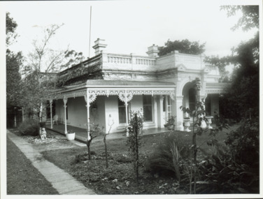
... Source: City of Kew Urban Conservation Study, 1988...Source: City of Kew Urban Conservation Study, 1988 Stables, 'Roseneath', Pakington Street Photograph Photograph J E & B L Rogers ...This work forms part of the collection assembled by the historian Dorothy Rogers, that was donated to the Kew Historical Society by her son John Rogers in 2015. The manuscripts, photographs, maps, and documents were sourced by her from both family and local collections or produced as references for her print publications. Many were directly used by Rogers in writing ‘Lovely Old Homes of Kew’ (1961) and 'A History of Kew' (1973), or the numerous articles on local history that she produced for suburban newspapers. Most of the photographs in the collection include detailed annotations in her hand.The Rogers Collection provides a comprehensive insight into the working habits of a historian in the 1960s and 1970s. Together it forms the largest privately-donated collection within the archives of the Kew Historical Society.'Roseneath' was constructed in stages in the I850s by John Ambrose Kitchen, a soap-maker. In 1870 the brick house received an N.A.V. of £60 while in 1885 it was purchased by Edward John Dunn, a geologist. A new wing was built at the right side of the house and several rooms as well as the coach house, loft and groom's quarters were added. In 1903, during Dunn's ownership, the property was described as having eight roorns. The garden is recorded as having been designed by Baron von Mueller who was the Government Botanist from 1853. Source: City of Kew Urban Conservation Study, 1988"32"historic houses -- kew (vic.), roseneath -- pakington street -- kew (vic.) -
Canterbury History Group
Document - Maling Road Shopping Centre and Residential Environs, 1997
... 1997 Review of Urban Conservation from Camberwell Conservation Study 1991...1997 Review of Urban Conservation from Camberwell Conservation Study 1991 Maling Roadshopping Centre and Residential Environs Canterbury Streets Canterbury Map of the Postcode 3126 Boroondara Planning Scheme 5 double-sided typed pages with one map Document Maling Road Shopping Centre and Residential Environs Camberwell Council - Conservation Study ...1997 Review of Urban Conservation from Camberwell Conservation Study 19915 double-sided typed pages with one mapmaling roadshopping centre and residential environs, canterbury streets, canterbury map of the postcode 3126, boroondara planning scheme -
Kew Historical Society Inc
Archive (series) - Subject File, Victoria Park : Concept Management Plan, Research Papers, 2004, 2004
... The Kew Urban Conservation Study was commissioned by the City of Kew, and submitted by Pru Sanderson Design Pty Ltd in 1988. ...Kew Historical Society Inc Kew Court House 188 High Street Kew melbourne The Kew Urban Conservation Study was commissioned by the City of Kew, and submitted by Pru Sanderson Design Pty Ltd in 1988. ...Graeme Butler & AssociatesProject FilesProvenance OrderRed cardboard wallet containing historical research by Graeme Butler, heritage architect, into the history of Victoria Park, Kew. The file also includes a draft Victoria Park Concept Master Plan, 2004. The research includes memoranda, maps, photocopies of plans, forms, notes, aerial photos, and sundry references.graeme butler - heritage architect, victoria park - kew (vic), heritage studies - kew (vic.)graeme butler - heritage architect, victoria park - kew (vic), heritage studies - kew (vic.) -
 Kew Historical Society Inc
Photograph - 'Otira', 73 Walpole Street, 1978
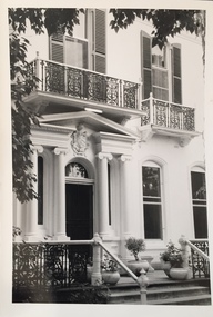
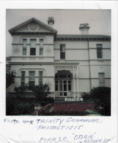
... Prue Sanderson, in the City of Kew Urban Conservation Study, Vol.2 (1988) stated that: 'The house originally had a fine cast iron verandah to two facades, however despite its removal, it remains as a most preposessing structure, The small cast iron perch is not original. ...Prue Sanderson, in the City of Kew Urban Conservation Study, Vol.2 (1988) stated that: 'The house originally had a fine cast iron verandah to two facades, however despite its removal, it remains as a most preposessing structure, The small cast iron perch is not original. ...Sanderson P (1988): '73 Walpole Street (Kew), 'Otira'. Built 1887. Original use - Residence. Architect - Crouch. Henry Berry, a noted philanthropist and salt merchant of Melbourne, was the original owner of this two-storey, boom-period house. Berry occupied the residence until his death in 1923 while in February the following year, the property was auctioned. Subsequently purchased by the Methodist Church for use as a training college for missionaries, a number of additions and alterations were made at that stage including a memorial chapel that was built on the property in 1957.' Otira is now a private residence. Original colour positive photograph (polaroid) of 'Otira', 73 Walpole Street, Kew, taken in 1978 by students in Form 3R at Trinity Grammar School as part of a project. The view in the photograph is of the front of the house, minus the first floor verandah that had been removed some decades before and preceding the reinstatement of the verandah sometime after 1988. Prue Sanderson, in the City of Kew Urban Conservation Study, Vol.2 (1988) stated that: 'The house originally had a fine cast iron verandah to two facades, however despite its removal, it remains as a most preposessing structure, The small cast iron perch is not original. Overall the design is in Italianate styling and the walls are clad in render, with extremely fine incised medallions in the render at both levels. The treatment of the tripartite windows with rounded upper corners is also atypical and is repeated in the joinery of the front entrance.'"Photo one / Trinity Grammar Project 1978 / Form 3R / "Otira" Walpole St"otira - 73 walpole street, henry berry, historic houses -- kew (vic.), trinity grammar school, melbourne architects -- crouch -
 Kew Historical Society Inc
Photograph - Lalla Rookh : 41 Fellows Street, Progress Press, 1978
... The first Kew Urban Conservation Study established that the house was built in 1897 for John Duncan, civil servant. ...The first Kew Urban Conservation Study established that the house was built in 1897 for John Duncan, civil servant. ...The National Trust (Victoria) citation on the Heritage Victoria Database describes Lalla Rookh as charming and rare example of a substantial domestic building from the depths of the depression of the 1890s. It was Classified by the Trust on 22/04/1971. The first Kew Urban Conservation Study established that the house was built in 1897 for John Duncan, civil servant. By 1910 William Robert Frayne, chemist, had purchased the property. When the building was listed by the National Estate the building was described as: '... Single-storied, the symmetrical, stuccoed house features a central porch with an arched opening and pedimented consoles and a bull-nose verandah which returns down both sides and is constructed with cast iron columns and friezes. A balustraded parapet crowns the main walls of the house. The encaustic tiled verandah is distinctive.'"Lalla Rookh", 41 Fellows Street, Kew, is of architectural interest as a representative example of a villa house of the period and also forms pan of the townscape of Kew. In a late version of Boom Style Classicism, the basically modest and conventionally planned house is proportioned to emphasise the porch and heavy balustrade, contrasting with the verandah and plain wall surfaces. The parapet may have had urns originally. The encaustic tiled verandah is of note. ... Of local significance.'Photographic print positive of the facade of Lalla Rookh at 41 Fellows Street, Kew.lalla rookh, houses -- fellows street -- kew (vic.), boom style architecture, architecture -- melbourne -- 1890s -
 Kew Historical Society Inc
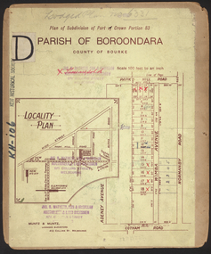
Plan, Studley Park Estate, 1910
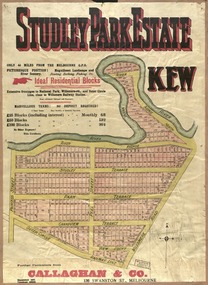
... Prue Sanderson, in her groundbreaking ‘City of Kew Urban Conservation Study : Volume 2 - Development History’ (1988), summarised the periods of urban development and subdivisions of land in Kew. ...Kew Historical Society Inc Kew Court House 188 High Street Kew melbourne Prue Sanderson, in her groundbreaking ‘City of Kew Urban Conservation Study : Volume 2 - Development History’ (1988), summarised the periods of urban development and subdivisions of land in Kew. ...Prue Sanderson, in her groundbreaking ‘City of Kew Urban Conservation Study : Volume 2 - Development History’ (1988), summarised the periods of urban development and subdivisions of land in Kew. The periods that she identified included 1845-1880, 1880-1893, 1893-1921, 1921-1933, 1933-1943, and Post-War Development. These periods were selected as they represented periods of rapid growth or decline in urban development. An obvious starting point for Sanderson’s groupings involved population growth and the associated economic cycles. These cycles also highlighted urban expansion onto land that was predominantly rural, although in other cases it represented the decline and breakup of large estates. A number of the plans in the Kew Historical Society’s collection can also be found in other collections, such as those of the State Library of Victoria and the Boroondara Library Service. A number are however unique to the collection.The Kew Historical Society collection includes almost 100 subdivision plans pertaining to suburbs of the City of Melbourne. Most of these are of Kew, Kew East or Studley Park, although a smaller number are plans of Camberwell, Deepdene, Balwyn and Hawthorn. It is believed that the majority of the plans were gifted to the Society by persons connected with the real estate firm - J. R. Mathers and McMillan, 136 Cotham Road, Kew. The Plans in the collection are rarely in pristine form, being working plans on which the agent would write notes and record lots sold and the prices of these. The subdivision plans are historically significant examples of the growth of urban Melbourne from the beginning of the 20th Century up until the 1980s. A number of the plans are double-sided and often include a photograph on the reverse. A number of the latter are by noted photographers such as J.E. Barnes.Coloured lithograph of a subdivision plan of the Studley Park Estate, bordered by Yarra, Willsmere Road and the Outer Circle Railway line. The estate was listed in 1910 and was the subject of a planning dispute between the developer and the Town of Kew in relation to flood levels and the suitability of the land for housing. In many cases the names of streets were subsequently changed. The layout was also affected by the creation of the Eastern Freeway. A newspaper report of the day described the subdivision as a: "GOLDEN OPPORTUNITY. We are pleased to submit for PRIVATE SALE that magnificent ESTATE, situated only 4 1/2 miles from the Melbourne General Post Office, STUDLEY PARK ESTATE. KF/NV. Doubtless the CHEAPEST LAND EVER OFFERED having extensive frontages to the prettiest spot on the River Yarra and the National Park, commanding lovely river and landscape views, and acknowledged to be the finest land available so close to the city. The PRICES ARE EXTREMELY MODERATE; The TERMS ARE SIMPLY MARVELLOUS. NO DEPOSIT. NO DEPOSIT. NO DEPOSIT. Allotments and prices to suit everyone."subdivision plans - kew, studley park estate -
 Kew Historical Society Inc
Plan, Studley Heights Estate, 1936
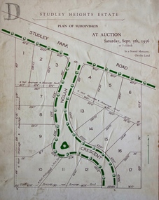
... Pru Sanderson, in her groundbreaking ‘City of Kew Urban Conservation Study : Volume 2 - Development History’ (1988), summarised the periods of urban development and subdivisions of land in Kew. ...Kew Historical Society Inc Kew Court House 188 High Street Kew melbourne Pru Sanderson, in her groundbreaking ‘City of Kew Urban Conservation Study : Volume 2 - Development History’ (1988), summarised the periods of urban development and subdivisions of land in Kew. ...Pru Sanderson, in her groundbreaking ‘City of Kew Urban Conservation Study : Volume 2 - Development History’ (1988), summarised the periods of urban development and subdivisions of land in Kew. The periods that she identified included 1845-1880, 1880-1893, 1893-1921, 1921-1933, 1933-1943, and Post-War Development. These periods were selected as they represented periods of rapid growth or decline in urban development. An obvious starting point for Sanderson’s groupings involved population growth and the associated economic cycles. These cycles also highlighted urban expansion onto land that was predominantly rural, although in other cases it represented the decline and breakup of large estates. A number of the plans in the Kew Historical Society’s collection can also be found in other collections, such as those of the State Library of Victoria and the Boroondara Library Service. A number are however unique to the collection.Subdivision plans are historically important documents used as evidence of the growth of suburbs in Australia. They frequently provide information about when the land was sold on which a built structure was subsequently constructed as well as evidence relating to surveyors and real estate and financial agents. The numerous subdivision plans in the Kew Historical Society's collection represent working documents, ranging from the initial sketches made in planning a subdivision to printed plans on which auctioneers or agents listed the prices for which individual lots were sold. In a number of cases, the reverse of a subdivision plan in the collection includes a photograph of a house that was also for sale by the agent. These photographs provide significant heritage information relating house design and decoration, fencing and household gardens.The ‘Studley Heights Estate’ on the South Side of Studley Park Road was launched in 1936. The seventeen allotments in the subdivision fronted Hyton Crescent and Studley Park Road.subdivision plans - kew, studley heights estate -
![Monnington [Estate], 1935](/media/collectors/550653872162f11fb04854aa/items/5907eb86d0ce0c14e82385c8/item-media/5907ecafd0ce0c14e823e87f/item-fit-380x285.jpg?cb=6) Kew Historical Society Inc
Kew Historical Society IncPlan - Subdivision Plan, Monnington [Estate], 1935, 1935
... Pru Sanderson, in her groundbreaking ‘City of Kew Urban Conservation Study : Volume 2 - Development History’ (1988), summarised the periods of urban development and subdivisions of land in Kew. ...Kew Historical Society Inc Kew Court House 188 High Street Kew melbourne Pru Sanderson, in her groundbreaking ‘City of Kew Urban Conservation Study : Volume 2 - Development History’ (1988), summarised the periods of urban development and subdivisions of land in Kew. ...Pru Sanderson, in her groundbreaking ‘City of Kew Urban Conservation Study : Volume 2 - Development History’ (1988), summarised the periods of urban development and subdivisions of land in Kew. The periods that she identified included 1845-1880, 1880-1893, 1893-1921, 1921-1933, 1933-1943, and Post-War Development. These periods were selected as they represented periods of rapid growth or decline in urban development. An obvious starting point for Sanderson’s groupings involved population growth and the associated economic cycles. These cycles also highlighted urban expansion onto land that was predominantly rural, although in other cases it represented the decline and breakup of large estates. A number of the plans in the Kew Historical Society’s collection can also be found in other collections, such as those of the State Library of Victoria and the Boroondara Library Service. A number are however unique to the collection.Subdivision plans are historically important documents used as evidence of the growth of suburbs in Australia. They frequently provide information about when the land was sold on which a built structure was subsequently constructed as well as evidence relating to surveyors and real estate and financial agents. The numerous subdivision plans in the Kew Historical Society's collection represent working documents, ranging from the initial sketches made in planning a subdivision to printed plans on which auctioneers or agents listed the prices for which individual lots were sold. In a number of cases, the reverse of a subdivision plan in the collection includes a photograph of a house that was also for sale by the agent. These photographs provide significant heritage information relating house design and decoration, fencing and household gardens.The first subdivision of Monnington took place in 1935. At that time, Monnington and 10 new allotments were offered for sale bordering Adeney and Marshall Avenues. In this subdivision plan, Monnington is one of 13 lots for sale. The subdivision created the irregular land holding of Monnington today. The excision of southwest corner of Monninton was caused by the need to have regular allotments facing the curve in Marshall Avenue.monnington - adeney avenue -- kew (vic.), subdivision plans -- kew (vic.) -
 Kew Historical Society Inc
Plan - Subdivision Plan, Goldthorns House Estate, 1940
... Pru Sanderson, in her groundbreaking ‘City of Kew Urban Conservation Study : Volume 2 - Development History’ (1988), summarised the periods of urban development and subdivisions of land in Kew. ...Kew Historical Society Inc Kew Court House 188 High Street Kew melbourne Pru Sanderson, in her groundbreaking ‘City of Kew Urban Conservation Study : Volume 2 - Development History’ (1988), summarised the periods of urban development and subdivisions of land in Kew. ...Pru Sanderson, in her groundbreaking ‘City of Kew Urban Conservation Study : Volume 2 - Development History’ (1988), summarised the periods of urban development and subdivisions of land in Kew. The periods that she identified included 1845-1880, 1880-1893, 1893-1921, 1921-1933, 1933-1943, and Post-War Development. These periods were selected as they represented periods of rapid growth or decline in urban development. An obvious starting point for Sanderson’s groupings involved population growth and the associated economic cycles. These cycles also highlighted urban expansion onto land that was predominantly rural, although in other cases it represented the decline and breakup of large estates. A number of the plans in the Kew Historical Society’s collection can also be found in other collections, such as those of the State Library of Victoria and the Boroondara Library Service. A number are however unique to the collection.The Kew Historical Society collection includes almost 100 subdivision plans pertaining to suburbs of the City of Melbourne. Most of these are of Kew, Kew East or Studley Park, although a smaller number are plans of Camberwell, Deepdene, Balwyn and Hawthorn. It is believed that the majority of the plans were gifted to the Society by persons connected with the real estate firm - J. R. Mathers and McMillan, 136 Cotham Road, Kew. The Plans in the collection are rarely in pristine form, being working plans on which the agent would write notes and record lots sold and the prices of these. The subdivision plans are historically significant examples of the growth of urban Melbourne from the beginning of the 20th Century up until the 1980s. A number of the plans are double-sided and often include a photograph on the reverse. A number of the latter are by noted photographers such as J.E. Barnes.The first subdivision of Goldthorns created the Goldthorns Hill Estate. Following that subdivision, seven additional lots were offered between Normanby Road, Argyle Road and Lady Loch’s Drive on the proviso that the estate, including Goldthorns was not sold as a single lot. The subdivision plan advises that the lots are situated in one of the most charming and popular residential areas in Kew and is surrounded by modern homes. Typically, the subdivision plan proposes the advantage of its proximity to Cotham Road and the tram to Collins Street. Because of the elevation of Goldthorns, much is made of the ‘bright, sunny and extensive outlook to the Northern Ranges’ and that it overlooks the Yarra Valley. One of the more interesting aspects of the plan is that it shows the outline of Goldthorns in the mid to late 1920s. Its profile today remains virtually the same."Goldthorns" House Estate at topsubdivision plans - kew, goldthorns house estate -
 Kew Historical Society Inc
Plan, Sydney Arnold Best & Co, Field Place, Kew, c.1929
... Pru Sanderson, in her groundbreaking ‘City of Kew Urban Conservation Study : Volume 2 - Development History’ (1988), summarised the periods of urban development and subdivisions of land in Kew. ...Kew Historical Society Inc Kew Court House 188 High Street Kew melbourne Pru Sanderson, in her groundbreaking ‘City of Kew Urban Conservation Study : Volume 2 - Development History’ (1988), summarised the periods of urban development and subdivisions of land in Kew. ...Pru Sanderson, in her groundbreaking ‘City of Kew Urban Conservation Study : Volume 2 - Development History’ (1988), summarised the periods of urban development and subdivisions of land in Kew. The periods that she identified included 1845-1880, 1880-1893, 1893-1921, 1921-1933, 1933-1943, and Post-War Development. These periods were selected as they represented periods of rapid growth or decline in urban development. An obvious starting point for Sanderson’s groupings involved population growth and the associated economic cycles. These cycles also highlighted urban expansion onto land that was predominantly rural, although in other cases it represented the decline and breakup of large estates. A number of the plans in the Kew Historical Society’s collection can also be found in other collections, such as those of the State Library of Victoria and the Boroondara Library Service. A number are however unique to the collection.The Kew Historical Society collection includes almost 100 subdivision plans pertaining to suburbs of the City of Melbourne. Most of these are of Kew, Kew East or Studley Park, although a smaller number are plans of Camberwell, Deepdene, Balwyn and Hawthorn. It is believed that the majority of the plans were gifted to the Society by persons connected with the real estate firm - J. R. Mathers and McMillan, 136 Cotham Road, Kew. The Plans in the collection are rarely in pristine form, being working plans on which the agent would write notes and record lots sold and the prices of these. The subdivision plans are historically significant examples of the growth of urban Melbourne from the beginning of the 20th Century up until the 1980s. A number of the plans are double-sided and often include a photograph on the reverse. A number of the latter are by noted photographers such as J.E. Barnes.An unnamed subdivision in Studley Park including five lots for sale in Studley Park Road, Highfield Grove and Tara Avenue. Unidentified on the plan, but clearly existing, are the Henty family mansion of Field Place and Tara Hall in Studley Park Road. The first attempted subdivision of Tara Hall was advertised in 1927 in which Lots 5, 6 and 7 in this plan were also advertised. Unusually, Lot 2 in Studley Park Road was created from the northern part of the Henty mansion, rather than Tara Hall. In the subdivision, lots were advertised at varying prices, with the highest price for land being Lot 2 in Studley Park Road. The plan notes that only one villa is to be allowed on each allotment.subdivision plans - kew, field place subdivision -- studley park – kew (vic.), highfield grove – kew (vic.), tara avenue – kew (vic.) -
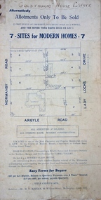
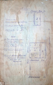
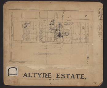 Kew Historical Society Inc
Plan - Subdivision Plan, Altyre Estate, 1920, 1920
... Pru Sanderson, in her groundbreaking ‘City of Kew Urban Conservation Study : Volume 2 - Development History’ (1988), summarised the periods of urban development and subdivisions of land in Kew. ...Kew Historical Society Inc Kew Court House 188 High Street Kew melbourne Pru Sanderson, in her groundbreaking ‘City of Kew Urban Conservation Study : Volume 2 - Development History’ (1988), summarised the periods of urban development and subdivisions of land in Kew. ...Pru Sanderson, in her groundbreaking ‘City of Kew Urban Conservation Study : Volume 2 - Development History’ (1988), summarised the periods of urban development and subdivisions of land in Kew. The periods that she identified included 1845-1880, 1880-1893, 1893-1921, 1921-1933, 1933-1943, and Post-War Development. These periods were selected as they represented periods of rapid growth or decline in urban development. An obvious starting point for Sanderson’s groupings involved population growth and the associated economic cycles. These cycles also highlighted urban expansion onto land that was predominantly rural, although in other cases it represented the decline and breakup of large estates. A number of the plans in the Kew Historical Society’s collection can also be found in other collections, such as those of the State Library of Victoria and the Boroondara Library Service. A number are however unique to the collection.The Kew Historical Society collection includes almost 100 subdivision plans pertaining to suburbs of the City of Melbourne. Most of these are of Kew, Kew East or Studley Park, although a smaller number are plans of Camberwell, Deepdene, Balwyn and Hawthorn. It is believed that the majority of the plans were gifted to the Society by persons connected with the real estate firm - J. R. Mathers and McMillan, 136 Cotham Road, Kew. The Plans in the collection are rarely in pristine form, being working plans on which the agent would write notes and record lots sold and the prices of these. The subdivision plans are historically significant examples of the growth of urban Melbourne from the beginning of the 20th Century up until the 1980s. A number of the plans are double-sided and often include a photograph on the reverse. A number of the latter are by noted photographers such as J.E. Barnes.The Altyre Estate was advertised for sale by auction in 1920. A colour lithograph in the State Library of Victoria, in contrast to this monochrome version, notes the proximity of the subdivision to the Auburn Heights Bowling Club and to a range of transport options. The subdivision included fifty-one allotments as well as the original house ‘Altyre’ in Barkers Road. This version includes the amounts paid as deposit on a number of lots.subdivision plans - kew, altyre estate – kew (vic), barkers road – kew (vic), walsh street – kew (vic), ross street – kew (vic), loxton street – kew (vic), mount street – kew (vic), auburn heights bowling club, altyre -
 Kew Historical Society Inc
Plan - Subdivision Plan, Wimba Estate, Kew, c.1925-c.1929, ca. 1925-ca. 1929
... Pru Sanderson, in her groundbreaking ‘City of Kew Urban Conservation Study : Volume 2 - Development History’ (1988), summarised the periods of urban development and subdivisions of land in Kew. ...Kew Historical Society Inc Kew Court House 188 High Street Kew melbourne Pru Sanderson, in her groundbreaking ‘City of Kew Urban Conservation Study : Volume 2 - Development History’ (1988), summarised the periods of urban development and subdivisions of land in Kew. ...Pru Sanderson, in her groundbreaking ‘City of Kew Urban Conservation Study : Volume 2 - Development History’ (1988), summarised the periods of urban development and subdivisions of land in Kew. The periods that she identified included 1845-1880, 1880-1893, 1893-1921, 1921-1933, 1933-1943, and Post-War Development. These periods were selected as they represented periods of rapid growth or decline in urban development. An obvious starting point for Sanderson’s groupings involved population growth and the associated economic cycles. These cycles also highlighted urban expansion onto land that was predominantly rural, although in other cases it represented the decline and breakup of large estates. A number of the plans in the Kew Historical Society’s collection can also be found in other collections, such as those of the State Library of Victoria and the Boroondara Library Service. A number are however unique to the collection.Subdivision plans are historically important documents used as evidence of the growth of suburbs in Australia. They frequently provide information about when the land was sold on which a built structure was subsequently constructed as well as evidence relating to surveyors and real estate and financial agents. The numerous subdivision plans in the Kew Historical Society's collection represent working documents, ranging from the initial sketches made in planning a subdivision to printed plans on which auctioneers or agents listed the prices for which individual lots were sold. In a number of cases, the reverse of a subdivision plan in the collection includes a photograph of a house that was also for sale by the agent. These photographs provide significant heritage information relating house design and decoration, fencing and household gardens.In 1925, the City of Kew called for tenders for the construction of Wimba Avenue, Cadow Street and Lalla Street. Subsequent advertisements for the sale of land in Wimba Avenue continued from 1926 to 1929. The 18 lots (and a further five allotments on the eastern side of the street) offered for sale were unofficially described in the subdivision plan as the ‘Wimba Estate’. These lots began in Park Hill Road and extended almost to Cotham Road. The subdivision took its name from the house ‘Wimba’ in Cotham Road, which may have formed the southern boundary of the subdivision. (Wimba, at 235 Cotham Road was constructed between 1862-70). The Plan highlights the proximity and advantage of ‘electric’ trams in Cotham and Glenferrie Roads, and the Kew and Glenferrie Railway Stations. An oddity in the Plan is the reference to the electric tram terminus at Burke Road, given that the tramline had already been extended to Mont Albert in 1916.wimba estate, subdivision plans - kew, parkhill road – kew (vic.), normanby road – kew (vic.), wimba avenue – kew (vic.)