Showing 70 items matching "verge"
-
 Whitehorse Historical Society Inc.
Article, Mitcham on the Verge, 2000
... Mitcham on the Verge...Mitcham on the Verge ...Mitcham on the Verge : article in The Age 'Domain' supplement, 29 November 2000....Mitcham on the Verge Article Article ...Article in The Age 'Domain' supplement, 29 November 2000.Mitcham on the Verge : article in The Age 'Domain' supplement, 29 November 2000.Article in The Age 'Domain' supplement, 29 November 2000.mitcham, age supplement -
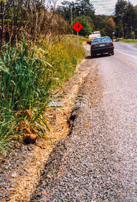 Eltham District Historical Society Inc
Photograph - Colour Print, Eltham Shire Council, Roadside verge issue, unidentified road, Eltham diistrict, c.1990, c.1990
... Roadside verge issue, unidentified road, Eltham diistrict, c.1990...Research-Warrandyte Road Roads shire of eltham Colour print on commercial photo paper Roadside verge issue, unidentified road, Eltham diistrict, c.1990 Photograph Colour Print Eltham Shire Council ...Possibly Research-Warrandyte Road near Researchell731 (vic reg), infrastructure, research (vic.), research-warrandyte road, roads, shire of eltham -
Whitehorse Historical Society Inc.
Article, Mitcham on the verge, 2000
... Mitcham on the verge...Brief description of Mitcham - past and present, accompanied by small map and a table containing median house and flat prices. Mitcham on the verge Article Article ...Brief description of Mitcham - past and present, accompanied by small map and a table containing median house and flat prices.Brief description of Mitcham - past and present, accompanied by small map and a table containing median house and flat prices.Brief description of Mitcham - past and present, accompanied by small map and a table containing median house and flat prices.mitcham, city of whitehorse -
 Lakes Entrance Historical Society
Photograph - WW1 Memorial avenue cypresses tree carvings by John Brady Esplanade Lakes Entrance 1999
... most westerly chain saw carving made from trunk of WW1 Memorial avenue cypresses. On lawn verge, south of Princes Highway, opposite Bellevue, Lakes Entrance Victoria Carved by chainsaw artist John Brady August 1998....Colour photograph of the most westerly chain saw carving made from trunk of WW1 Memorial avenue cypresses. On lawn verge, south of Princes Highway, opposite Bellevue, Lakes Entrance Victoria...most westerly chain saw carving made from trunk of WW1 Memorial avenue cypresses. On lawn verge, south of Princes Highway, opposite Bellevue, Lakes Entrance Victoria Carved by chainsaw artist John Brady August 1998. ...most westerly chain saw carving made from trunk of WW1 Memorial avenue cypresses. On lawn verge, south of Princes Highway, opposite Bellevue, Lakes Entrance Victoria Carved by chainsaw artist John Brady August 1998.Colour photograph of the most westerly chain saw carving made from trunk of WW1 Memorial avenue cypresses. On lawn verge, south of Princes Highway, opposite Bellevue, Lakes Entrance Victoriaworld war 1914-1918, memorials -
National Wool Museum
Ashtray
... La Laine: lavable machine PURE LAINE VERGE/ 100% lavable machine...Wool Marketing Australian Wool Corporation Gunn Sir William La Laine: lavable machine PURE LAINE VERGE/ 100% lavable machine Ashtray ...White ceramic square ashtray, promoting "La Laine: lavable machine" (Machine washable wool). Part of a collection of Australian Wool Corporation promotional memorabilia believed to have used in the era of Sir William Gunn.La Laine: lavable machine PURE LAINE VERGE/ 100% lavable machinewool marketing, australian wool corporation, gunn, sir william -
Victorian Aboriginal Corporation for Languages
DVD, The linguists, 2009
... Travelling linguists David and Greg document languages on the verge of extinction....Victorian Aboriginal Corporation for Languages 33 Saxon Street Brunswick melbourne language revival linguistics DVD Travelling linguists David and Greg document languages on the verge of extinction. The linguists DVD Seth Kramer ...Travelling linguists David and Greg document languages on the verge of extinction.DVDlanguage revival, linguistics -
 Marysville & District Historical Society
Book, Bill Bate, Marysville Ten Years On, 2019
... Front cover has a photograph of a statue of a girl holding a bird that is on the verge of flying....Box 22 / Marysville 3779 Front cover has a photograph of a statue of a girl holding a bird that is on the verge of flying. Marysville Ten Years On Book Book Bill Bate Anne Richey Ali Griffin ...A book of photographs taken to commemorate the ten year anniversary of the 2009 Black Saturday bush fire that destroyed most of Marysville.Front cover has a photograph of a statue of a girl holding a bird that is on the verge of flying.non-fictionA book of photographs taken to commemorate the ten year anniversary of the 2009 Black Saturday bush fire that destroyed most of Marysville.marysville, ten year anniversary, black saturday, bushfire, celebration -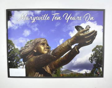
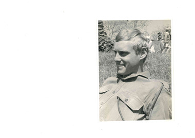 National Vietnam Veterans Museum (NVVM)
Photograph - B & W image
... Black and white image of young soldier in uniform reclining on grass verge. There is a child in the background....Black and white image of young soldier in uniform reclining on grass verge. There is a child in the background. ...Image of National Serviceman Pte John Rolf Johansen, Service No: 3790811, who served in 9th Battalion, The Royal Australian Regiment, from 04 Nov 1968 until 17 March 1969. John worked as a fisherman at San Remo, Victoria.Black and white image of young soldier in uniform reclining on grass verge. There is a child in the background.See accompanying letter for extra detail. -
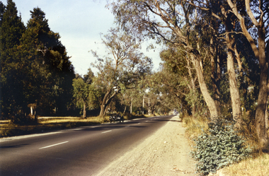 Whitehorse Historical Society Inc.
Photograph, Canterbury Road, Vermont, 1967
... Coloured photo of Canterbury Road, Vermont, taken in 1967 showing one lane road and heavily treed verge....Not used. canterbury road vermont shambrook tim Coloured photo of Canterbury Road, Vermont, taken in 1967 showing one lane road and heavily treed verge. Canterbury Road, Vermont. Photograph Photograph ...Part of Tim Shambrook's Collection for 'This is Vermont'. Not used.Coloured photo of Canterbury Road, Vermont, taken in 1967 showing one lane road and heavily treed verge.canterbury road, vermont, shambrook, tim -
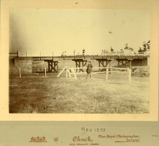 Clunes Museum
Photograph, CHUCK - GOLD MEDALLIST, LONDON. VICE REGAL PHOTOGRAPHER
... MAN STANDING ON BRIDGE - ALSO MAN STANDING ON GRASS VERGE BY CREEK....MAN STANDING ON BRIDGE - ALSO MAN STANDING ON GRASS VERGE BY CREEK. Photograph PHOTOGRAPH CHUCK - GOLD MEDALLIST, LONDON. ...ORIGINAL PHOTOGRAPH OF WOODEN BRIDGE WITH BLUESTONE BUTTRESS. MAN STANDING ON BRIDGE - ALSO MAN STANDING ON GRASS VERGE BY CREEK.local history, photography, photographs, bridges -
Ringwood and District Historical Society
Booklet, City of Ringwood, City of Ringwood Annual Statement of Accounts 1963, 1963
... +Additional Keywords: Dwerryhouse, F.P. / Verges, P...+Additional Keywords: Dwerryhouse, F.P. / Verges, P City of Ringwood Annual Statement of Accounts 1963 Booklet City of Ringwood ...Assembled and presented at a meeting of the council on 12 December 1963 - the annual statement of accounts for the year ended 30-Sep-1973.City of Ringwood Annual Statement of Accounts 1963. Pale green covered book with 34 roneoed pages of text and figures. +Additional Keywords: Dwerryhouse, F.P. / Verges, PCity of Ringwood Annual Statement of Accounts 1963 -
 Ringwood and District Historical Society
Photograph, Old Lilydale Road, Ringwood East circa 1970
... Showing the centre verge of stringybark trees between the service road and the main road, near number 10 Old Lilydale Road....Showing the centre verge of stringybark trees between the service road and the main road, near number 10 Old Lilydale Road. ...Donated from Croydon Conservation Society. Showing the centre verge of stringybark trees between the service road and the main road, near number 10 Old Lilydale Road. -
 Hume City Civic Collection
Photograph, c late 1980s
... There is a wide grassy verge in the foreground....There is a wide grassy verge in the foreground. Photograph ...The photograph shows a section of the original settlement of the Bulla township. The cutting on the hillside is significant as it is the remains of one of the original stream crossings in Victoria.A coloured photograph of the Bulla Hill along Sunbury Road with a view of the cutting on the distant hillside. The photograph is a view of the old Bulla township looking to the NW. There is a wide grassy verge in the foreground.bulla township, deep creek, wright, william 'tulip', sunbury road, george evans collection -
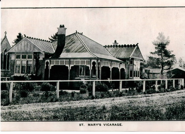 Sunbury Family History and Heritage Society Inc.
Photograph, ST. MARY'S VICARAGE
... There is a white post and rail front fence and a 1920s vintage car is parked on the verge....There is a white post and rail front fence and a 1920s vintage car is parked on the verge. ST. MARY'S VICARAGE Photograph ...This vicarage to be built for St. Mary's Church in O' Shanassy Street, Sunbury. It replaced Priorswood which was over a kilometre from the church. It was demolished in the 1960s to be replaced by a modern brick residence, which in turn was demolished to make way for the building of 8 Oaks Community Centre.A non-digital back and white photograph of Federation style brick house with a corrugated iron roof. There is a white post and rail front fence and a 1920s vintage car is parked on the verge.vicarages, st. mary's vicarage, o'shanassy street, sunbury, st. mary's church of england -
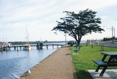
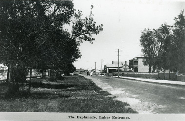
 Lakes Entrance Historical Society
Photograph - Esplanade Lakes Entrance 1999
... It shows vessels moored at jetty path beside Lakes, seats and picnic tables and newly planted trees on lawn verge of highway. Lakes Entrance Victoria...It shows vessels moored at jetty path beside Lakes, seats and picnic tables and newly planted trees on lawn verge of highway. Lakes Entrance Victoria Photograph Esplanade Lakes Entrance 1999 ...Date made 10 April 1999Color photograph of Esplanade and waterfront. It shows vessels moored at jetty path beside Lakes, seats and picnic tables and newly planted trees on lawn verge of highway. Lakes Entrance VictoriaThe Esplanade Lakes Entrance 10/4/99 (on back)jetties, waterfront, boats and boating -
 Ballarat Heritage Services
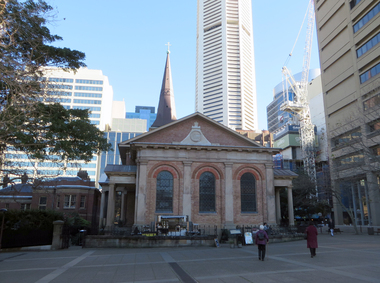
Photograph - Colour Photograph, St James' Anglican Church, King Street, Sydney, 16/07/2019
... The church was consecrated in 1824. John Verge built the vestries in 1832. T...The church was consecrated in 1824. John Verge built the vestries in 1832. T St James' Sydney St James King St Children's chapel Photographs of St James' Anglican Church, King Street, Sydney St James' Anglican Church, King Street, Sydney Photograph Colour Photograph ...The foundation stone of St James Church in Sydney was laid in 1819, and was designed by Francis Greenway. The church was consecrated in 1824. John Verge built the vestries in 1832. TPhotographs of St James' Anglican Church, King Street, Sydneyst james' sydney, st james king st, children's chapel -
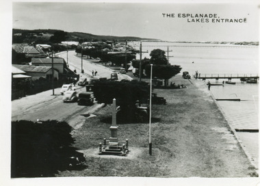
 Lakes Entrance Historical Society
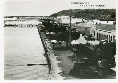
Postcard - Foreshore Lakes Entrance, 1945c
... Black and white small format postcard of the foreshore, showing jetties at the boat harbour opposite the Post Office, truck parked in front of Central Hotel, cars parked on the verge between road and lake. Lakes Entrance Victoria...Township Waterfront Transport Black and white small format postcard of the foreshore, showing jetties at the boat harbour opposite the Post Office, truck parked in front of Central Hotel, cars parked on the verge between road and lake. Lakes Entrance Victoria Postcard Foreshore Lakes Entrance ...From a wallet of miniature postcards published by H D Bulmer for sale as tourist souvenirs.Black and white small format postcard of the foreshore, showing jetties at the boat harbour opposite the Post Office, truck parked in front of Central Hotel, cars parked on the verge between road and lake. Lakes Entrance Victoriatownship, waterfront, transport -
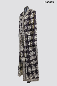 Whitehorse Historical Society Inc.
Clothing - Black & white dress, C 1970's
... - Indian cotton printed dress (block printed) - Wrap style, long sleeves, tie belt, side splits - Skillful use of block printing in dress design - Black colour washed out, verging on dark brown...Clothing Indian Block printed 'Dellriwala" Handmade in India 100% cotton size 8 - Indian cotton printed dress (block printed) - Wrap style, long sleeves, tie belt, side splits - Skillful use of block printing in dress design - Black colour washed out, verging on dark brown Clothing Black & white dress Dellriwala ...1970's Indian cotton, block printed dress.- Indian cotton printed dress (block printed) - Wrap style, long sleeves, tie belt, side splits - Skillful use of block printing in dress design - Black colour washed out, verging on dark brown'Dellriwala" Handmade in India 100% cotton size 8clothing, indian, block printed -
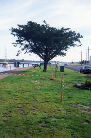
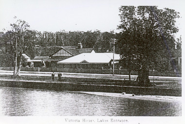 Lakes Entrance Historical Society
Photograph - Victoria House Lakes Entrance c1920
... Two coastal banksias on verge of road, two men standing on rock wall. ...Two coastal banksias on verge of road, two men standing on rock wall. ...Photo taken prior to 1924, no memorial cypress trees. Later known as Sparkle Motel in the 1960's and Esplanade Motel in 2000'sBlack and white tinted photograph of Victoria House, showing a group of buildings on Esplanade. Rock wall on edge of lake. Two coastal banksias on verge of road, two men standing on rock wall. Lakes Entrance VictoriaVictoria House Lakes Entranceguesthouses, waterfront, architecture -
 Greensborough Historical Society
Newsletter, Greenhills and North Greensborough Progress Association, Community News: official journal of the Greenhills and Nth. Greensborough Progress Association and the Apollo Parkways Progress Association. 5th December, 1975, 05/12/1975
... This edition includes a report on the Apollo Parkways Progress Association's November 1975 meeting, International Women's Year, This and that, Natural roadside verges. A digital copy of this Newsletter is available from Greensborough Historical Society....Greensborough Historical Society 34A Glenauburn Road Lower Plenty Lower Plenty melbourne This edition includes a report on the Apollo Parkways Progress Association's November 1975 meeting, International Women's Year, This and that, Natural roadside verges. A digital copy of this Newsletter is available from Greensborough Historical Society. ...This edition includes a report on the Apollo Parkways Progress Association's November 1975 meeting, International Women's Year, This and that, Natural roadside verges. A digital copy of this Newsletter is available from Greensborough Historical Society.Newsletter, 6 p., illus.greenhills and north greensborough progress association, greenhills, apollo parkways progress association, apollo parkways -
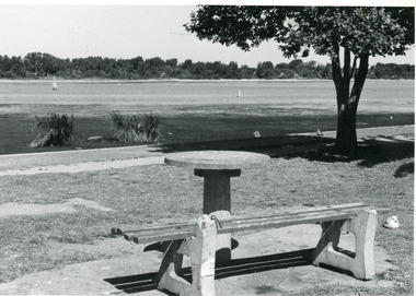 Lakes Entrance Historical Society
Photograph - Cunninghame Arm Lakes Entrance Victoria c1992, Lakes Post Newspaper
... It shows the scrub covered south shore, the Cunninghame Arm, the foreshore littered with dead seagrass, the path and lawn verge, and small concrete picnic table and broken seat. ...It shows the scrub covered south shore, the Cunninghame Arm, the foreshore littered with dead seagrass, the path and lawn verge, and small concrete picnic table and broken seat. ...Black and white photograph of part of the lake and waterfront. It shows the scrub covered south shore, the Cunninghame Arm, the foreshore littered with dead seagrass, the path and lawn verge, and small concrete picnic table and broken seat. Lakes Entrance Victoria waterways, topography -
 Lakes Entrance Historical Society
Postcard - Cenotaph , Esplanade Lakes Entrance, 1945c
... In the foreground is the Cenotaph erected 1922 on the grass verge between road and lake. Trimmed WW1 Cypress trees also on verge. ...In the foreground is the Cenotaph erected 1922 on the grass verge between road and lake. Trimmed WW1 Cypress trees also on verge. ...Black and white small format postcard of Esplanade, taken from the WW2 Air Observers Spotting Tower. In the foreground is the Cenotaph erected 1922 on the grass verge between road and lake. Trimmed WW1 Cypress trees also on verge. Cars and truck on highway all travelling in easterly direction. Houses and businesses on north side of road, Princes Highway, which follows the margin of the lake shore. Lakes Entrance Victoria Original from wallet of miniature postcards produced by Bulmer, two copies. 01419.1 and .2 Also two enlargements 17 x 25 cmThe Esplanade Lakes Entrancetownship, waterfront, transport, world war 1939 - 1945, world war 1914-1918 -
 Lakes Entrance Historical Society
Photograph - Esplanade waterfront, jetty sign posted as Bank Jetty. Lakes Entrance Victoria 1999
... Colour photograph of Esplanade and waterfront, it shows vessels moored at jetty, bluestone rocks edging path beside lake seats and picnic tables and newly planted trees on lawn verge of highway, jetty sign posted as Bank Jetty. ...Date made 10 April 1999 Jetties Waterfront Boats and Boating Colour photograph of Esplanade and waterfront, it shows vessels moored at jetty, bluestone rocks edging path beside lake seats and picnic tables and newly planted trees on lawn verge of highway, jetty sign posted as Bank Jetty. ...Date made 10 April 1999Colour photograph of Esplanade and waterfront, it shows vessels moored at jetty, bluestone rocks edging path beside lake seats and picnic tables and newly planted trees on lawn verge of highway, jetty sign posted as Bank Jetty. Lakes Entrance Victoriajetties, waterfront, boats and boating -
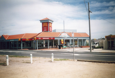 Lakes Entrance Historical Society
Photograph - MacDonalds Restaurant Lakes Entrance Victoria c2003, Bennett, Vera
... In foreground three bollards to limit parking on verge between Princes Highway and lake. Building of shops behind McDonald's being commenced. ...In foreground three bollards to limit parking on verge between Princes Highway and lake. Building of shops behind McDonald's being commenced. ...The McDonalds store was opened on 19 December 1987Colour photograph of McDonald's restaurant, Esplanade. A small truck on laneway between McDonald's and Hookers Estate Agent. In foreground three bollards to limit parking on verge between Princes Highway and lake. Building of shops behind McDonald's being commenced. Lakes Entrance Victoriatownship, restaurant -
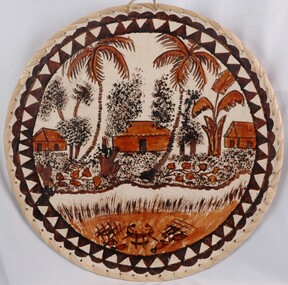 Glenelg Shire Council Cultural Collection
Artwork, other - Tongan - Tapa Cloth, n.d
... The creek is edged by a sandy verge and reeds. In the creek are fish traps. ...The creek is edged by a sandy verge and reeds. In the creek are fish traps. ...Circular tapa cloth on masonite backing board, with edges sewn with plant fibre. Scene painted on cloth depicts huts with palm trees by the side of a creek. The creek is edged by a sandy verge and reeds. In the creek are fish traps. The image is painted in black and dark ochre dyes. -
 Lakes Entrance Historical Society
Photograph - The Esplanade Lakes Entrance c1920
... Natural vegetation of Coastal Banksia on grass verge between road and waterfront, and beside Maranui Guest House. ...Natural vegetation of Coastal Banksia on grass verge between road and waterfront, and beside Maranui Guest House. ...Also 10 x 15 cm sepia copy, has remnants of glue of the back, little bit fadedBlack and white photograph of Esplanade, showing Maranui Guest House, Police Station, corner of Bellevue Guest House and Club Hotel in distance. Natural vegetation of Coastal Banksia on grass verge between road and waterfront, and beside Maranui Guest House. Lakes Entrance VictoriaThe Esplanade Lakes Entrancewaterfront, township, guesthouses, police -
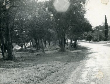
 Eltham District Historical Society Inc
Photograph, Brougham Street, Eltham, c. Sep. 1966
... In the distance on the right hand verge there is a large Eucalyptus tree with a branch growing out over the road. ...In the distance on the right hand verge there is a large Eucalyptus tree with a branch growing out over the road. ...Taken from alongside the Justice Precinct looking east. In the distance on the right hand verge there is a large Eucalyptus tree with a branch growing out over the road. That tree still stands today and is outside No. 102. The two houses on the right are possibly numbers 94 and 96.Black and white photographic printOriginally located in a Filmpro King Size Prints processing envelope $3.01 Shire of Eltham 9/9/66 and noted as Calrossie Ave area and crossed out Eltham-Yarra Glen Road, Bridge Street to Elsa Court existing conditions mid 1967brougham street, eltham, infrastructure, road construction, roads -
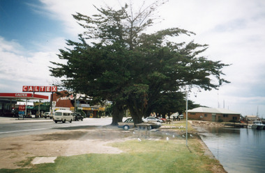 Lakes Entrance Historical Society
Photograph - Caltex Service Station, Caltex Service Station, Cunninghame Arm Nursery with Sallys Restaurant upstairs, Lakes Entrance Victoria, 1998
... Colour photograph of Esplanade, showing the Caltex Service Station, Cunninghame Arm Nursery with Sallys Restaurant upstairs, cypress trees on verge between road and lake, Ocean Rescue headquarters on bank of lake with rescue vessel moored at jetty, glimpse of Eastern Wharf in background. ...Lakes Entrance Historical Society 4 Marine Parade Lakes Entrance gippsland Date made 2 February 1998 Township Waterfront Memorials Retail Trade Emergency Services Colour photograph of Esplanade, showing the Caltex Service Station, Cunninghame Arm Nursery with Sallys Restaurant upstairs, cypress trees on verge between road and lake, Ocean Rescue headquarters on bank of lake with rescue vessel moored at jetty, glimpse of Eastern Wharf in background. ...Date made 2 February 1998Colour photograph of Esplanade, showing the Caltex Service Station, Cunninghame Arm Nursery with Sallys Restaurant upstairs, cypress trees on verge between road and lake, Ocean Rescue headquarters on bank of lake with rescue vessel moored at jetty, glimpse of Eastern Wharf in background. Lakes Entrance Victoriatownship, waterfront, memorials, retail trade, emergency services -
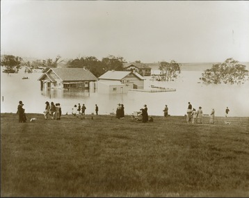 Kew Historical Society Inc
Photograph - Yarra in Flood from Willsmere, North Kew, 1923
... Original, large sepia photograph showing men, women and children who have gathered on a grassy verge, probably farm land, to look out across the flooded Yarra Valley at Willsmere, North Kew. ...While floods continued after the development of the Upper Yarra Reservoir (construction 1948-57), the regularity and extent of these inundations diminished. yarra river valley Kew East (vic.) floods willsmere Inscribed reverse: "Gift of Kerrie Woollard (KCC) (P)C.1923 Original, large sepia photograph showing men, women and children who have gathered on a grassy verge, probably farm land, to look out across the flooded Yarra Valley at Willsmere, North Kew. ...Flooding of the Yarra Valley, including that section of the Yarra bordering Kew and Kew East in the north and west of the municipality, was a regular occurrence. Extreme flood events of the Yarra River are recorded to have occurred in 1891, 1901, 1916, 1923 and 1934. The Municipality of Kew's response to these floods was to enact planning decisions restricting residential development in flood prone areas following the floods of 1916, 1921, and 1934. While floods continued after the development of the Upper Yarra Reservoir (construction 1948-57), the regularity and extent of these inundations diminished. Original, large sepia photograph showing men, women and children who have gathered on a grassy verge, probably farm land, to look out across the flooded Yarra Valley at Willsmere, North Kew. In the medium distance are three houses that are largely submerged by the flood waters as well as a number of Eucalypts. Inscribed reverse: "Gift of Kerrie Woollard (KCC) (P)C.1923yarra river valley, kew east (vic.), floods, willsmere