Showing 139 items matching viaduct
-
 Malmsbury Historical Society
Photograph (Item), Exhibition Of Memorabilia 1990 Viaduct, Malmsbury ca1990
Associated with - M.H.S. Buildings - Mechanics Institute People - "Bates, A" -
 Malmsbury Historical Society
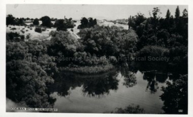
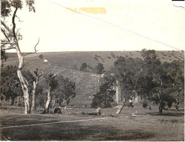
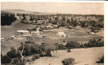
Photograph (Item), River View Near Viaduct, Malmsbury ca1930
Buildings - Malmsbury Mill -
 Malmsbury Historical Society
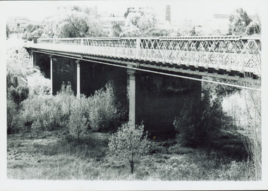
Postcard (Item), Railway Viaduct Over Coliban River At Malmsbury, Malmsbury ca1940
Buildings - Coliban River & Malmsbury Mill -
 Victorian Railway History Library
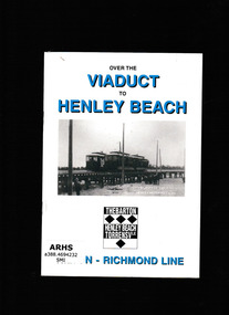
Book, Australian Electric Transport Museum (SA) Inc, Over the viaduct to Henley beach, 1997
The story of the horse and electric tramway to Henley beachIll, p.20.non-fictionThe story of the horse and electric tramway to Henley beachtramways - adelaide, horse tramways - adelaide -
 Ringwood and District Historical Society
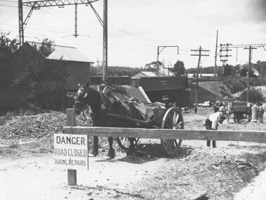
Photograph, Construction of railway viaduct in Pitt Street, Ringwood - circa 1923, south side looking east
Black and White photograph of horse and dray at construction siteType below one copy: Making Warrandyte Rd Subway, 1923 Taken from Pitt St. -
 Orbost & District Historical Society
black and white photographs, 15th February 1971
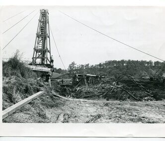
The 1971 flood was the the worst flood on record. At Jarrahmond it was at least 11 metres and up to one and a half kilometres wide on the flats causing enormous damage to the flood plain. Records say that "The brown floodwater stain in Bass Strait could be seen from passing airliners." Considerable damage was done to railway infrastructure, roads and farms. More information from the APRIL, 2008 newsletter by John Phillips. (see orbosthistory.com.au) The railway line was destroyed and was not expected to be opened for a fortnight. Orbost was cut off by 50 square miles of Snowy River floodwater. These photographs are pictorial records of the 1971 floods which was a significant event in the history of Orbost. They are also associated with the East Gippsland Railway.Three black / white photographs of flood debris and flood waters near a railway line. 3102.l has a pile driver 3102.2 shows a gap in the viaduct and 3102.3 shows men with a tractor cleaning up the debris,3102.1 - on back - "1971 FLOOD REPAIRS TO ORBOST RAILWAY VIADUCT - 15th February 1971. Donated by Audrey Van Den Berg VRH 3693" 3102.2 - on back - " DAMAGE TO RAILWAY VIADUCT ACCUMULATED DEBRIS" 3102.3 - on back - "DAMAGE TO RAILWAY VIADUCT AT ORBOST. CLEAN UP BEGINS"orbost-flood-1971 orbost-viaduct-flood-damage orbost-railway -
 Hume City Civic Collection
Photograph
This image is of the Viaduct at Rupertswood across the Jacksons CreekA black and white photo of the viaduct at Rupertswood across the Jackson's Creek with several gum trees in the foreground. There are electric power lines along the railway line.rupertswood, jackson's creek, railways, bridges, george evans collection -
 Flagstaff Hill Maritime Museum and Village
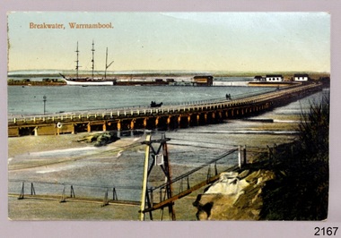
Postcard - Historical, maritime, Breakwater, Warrnambool
Postcard of Warrnambool breakwater (with viaduct in foreground). Coloured.flagstaff hill, warrnambool, shipwrecked-coast, flagstaff-hill, flagstaff-hill-maritime-museum, maritime-museum, shipwreck-coast, flagstaff-hill-maritime-village, postcard, warrnambool breakwater, viaduct, warrnambool viaduct -
 Orbost & District Historical Society
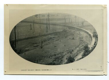
black and white photograph, Vogt. W.S, first half 20th century
In 1912 work was underrway on the Bairnsdale to Orbost railway. It was opened on April 10 1916. The two bridges on the railway viaduct, which crosses the Snowy River floodplain at Orbost, were built from local Southern Mahogany. The bridge on the Bairnsdale end (770m) is now the longest in Victoria. (info. Helen Martin)This item is associated with the history of the Orbost-Bairnsdale railway line and therefore reflects the role that the rail line played in the social and economic history of Orbost.A black / white photograph, oval-shaped on white background. It is of the railway viaduct across the flats at Orbost,.photo caption -"ORBOST RAILWAY BRIDGE, NEWMERELLA E. S. Vogt, Bairnsdale"newmerella orbost-viaduct east-gipsland-railway -
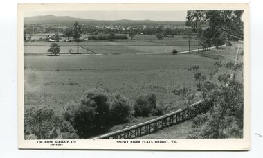
 Orbost & District Historical Society
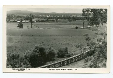
black and white photograph, Rose Stereograph Company, first half 20th century
The two bridges on the railway viaduct, which crosses the Snowy River floodplain at Orbost, were built from local Southern Mahogany. The bridge on the Bairnsdale end (770m) is now the longest in Victoria. Despite various attempts to extend the line, the station stayed on the western side of the Snowy River. (info. Helen Martin)This item is associated with the history of the Orbost-Bairnsdale railway line and therefore reflects the role that the rail line played in the social and economic history of Orbost.A black / white photograph / postcard of the Orbost township in the background and the railway viaduct over the flats in the foreground.photo caption - The Rose Series P.479 copywright SNOWY RIVER FLATS, ORBOST, VIC"east-gippsland-railway orbost-viaduct -
 Hume City Civic Collection
Photograph, 1990-1999
Two viaduct bridges were constructed across the Jacksons Creek valley at Rupertswood on the Bendigo rail line to bring the trains down the steep incline into Sunbury station.A photograph of the railway viaduct bridge showing one end of the span and 4 of the pylons. This bridge crosses the Jackson's Creek near one of the waterfalls which have been constructed in the creek. A large tree trunk is in the foreground of the photograph.rupertswood, clarke, william (sir), rupert (sir), michael (sir), victorian railways, salesian college, railways, bridges, jacksons creek, sunbury railway station, sunbury, george evans collection -
 Ballarat Heritage Services
Digital photographs, L.J. Gervasoni, Sunset Middle Island, 2009-2012
Digital images of a sunset at Middle Island, Warrnambool. seascape, sunset, coast, coastal, landscape, middle island, merri island, stingray bay, warrnambool -
 Ballarat Heritage Services
Digital photographs, L.J. Gervasoni, Middle Island Warrnambool, 2012
Digital images of Middle Island Stingray Bay warrnamboolvictoria, river, mouth, coast, ocean, island, middle, middle island, warrnambool, merri, merri river -
 Ballarat Heritage Services
Digital photographs, L.J. Gervasoni, Warrnambool pelicans, c2015
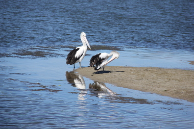
Colour photograph of two pelicans and their refletions at the Warrnambool beach.warrnambool, merri river, pelicans, birds, estuary, coastal -
 Ballarat Heritage Services
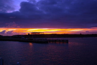
Digital photographs, L.J. Gervasoni, Warrnambool at night, c2015
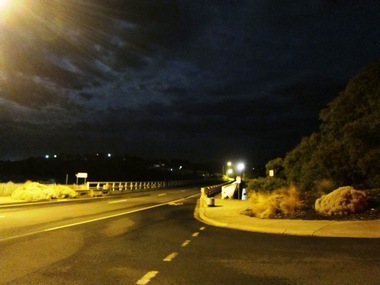
warrnambool, merri river, estuary, coastal, night -
 Ballarat Heritage Services
Digital photographs, L.J. Gervasoni, Harbour Pavilion under construction, c2010
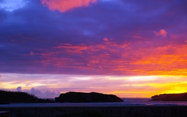
warrnambool, coast, coastal, beach, seascape, harbour pavilion, construction, sunset, viaduct road, breakwater -
 Ballarat Heritage Services
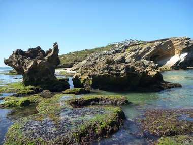
Digital photographs, L.J. Gervasoni, Geology at Stingray Bay / middle island, c2010
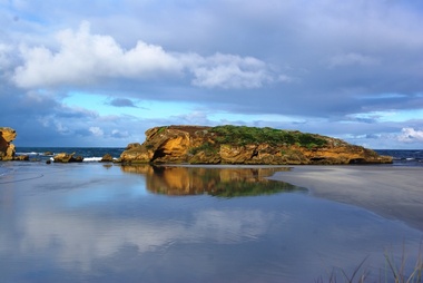
Colour photograph of Middle Island, Warrnambool.warrnambool, landscape, seascape, ocean, water, middle island, stingray bay, geology, coastal geomorphology -
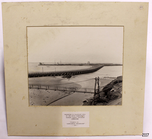 Flagstaff Hill Maritime Museum and Village
Photograph
Photograph of Port of Warrnambool - viaduct to Warrnambool breakwaterflagstaff hill, warrnambool, shipwrecked-coast, flagstaff-hill, flagstaff-hill-maritime-museum, maritime-museum, shipwreck-coast, flagstaff-hill-maritime-village -
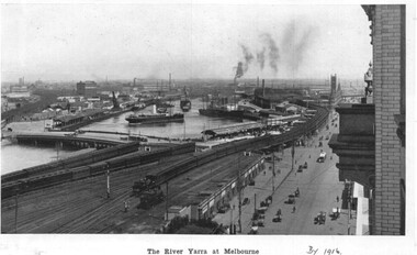 Melbourne Tram Museum
Photograph - Illustration, c1916
Illustration from a photograph reproduced in a magazine of the river Yarra, Flinders St railway yard, the viaduct, the swing basin, the wharves and Queens Bridge. Has a number of cable cars and trains in the view. Taken prior to the construction of the second or duplicate viaduct which was completed during 1915. Construction of the second viaduct on the south side of the original can be seen.in ink in bottom right hand comer "By 1916"trams, tramways, flinders st, railways, shipping, cable trams -
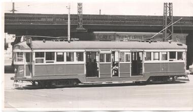 Melbourne Tram Museum
Photograph - Black & White Photograph/s, 1960's?
Black and white photograph of W2 291, eastbound in Flinders St with the Flinders St viaduct and the Viaduct Coffee Lounge shop in the background. Tram showing Route 28 (City Richmond) . No known details of the photographer or date.trams, tramways, flinders st, w2 class, route 28, tram 291 -
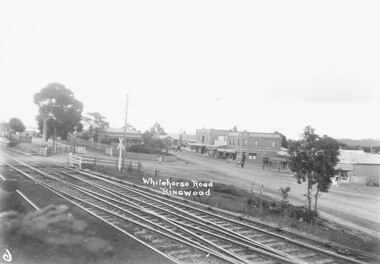 Ringwood and District Historical Society
Photograph, Whitehorse Road, Ringwood
Black and white photograph of old railway crossing before the viaduct was built. (2 copies)Stamp of photographer on back of photograph reads, "T.R.G. Williams, Photographer, Ringwood" -
 Kew Historical Society Inc
Photograph, Outer Circle Railway Bridge over River Yarra, c.1900
This photograph forms part of the Eric Sibly collection of images and information relating to the Outer Circle Railway which he donated to the Kew Historical Society in 1974. Heritage Victoria Citation (Abridged) "The Chandler Highway Bridge, a 137 metre wrought iron lattice-truss girder bridge with four spans supported on red brick piers with moulded bluestone cappings. The bridge has a cantilevered walkway along the west side. ...The Chandler Highway Bridge crosses the Yarra River and connects Alphington and Kew. It was completed in November 1890 as part of the Outer Circle Railway Line.Black & white photograph of the railway viaduct over Yarra River looking south towards Kew.Reverse: "Pre 1930. Outer Circle Railway Bridge over River Yarra (now Chandler Highway) - note bridge over line on Kew side for Asylum Farm". KH - 56. Kew Historical Society.chandler highway, railway bridges - kew (vic), sir john monash, outer circle railway, river yarra - kew (vic) -
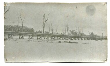 Orbost & District Historical Society
black and white photograph, January 1934
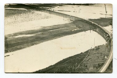
Orbost has been subject to major floods throughout its history, such as those which left the town isolated in 1934, 1952, 1971 and 1978. It is recorded that the Snowy River broke its banks and flooded the flats 104 times between 1884 and 1978. Extensive flooding in Eastern Victoria during June 1978, caused widespread damage to roads, road closures and hazards to traffic, particularly over the Queen's Birthday holiday weekend.This is a pictorial record of a significant event in Orbost's history.A very faded black / white photograph of flood water under the railway viaduct at watt's Gulch.orbost-flood-1934 railway-viaduct-orbost -
 Orbost & District Historical Society
black and white postards, Rose Stereograph Company, 1940s -1950s
These postcards are part of the Rose series of photograph / postcards taken around Victoria. Rose was born in Clunes in 1861 and later worked in his father’s boot-making business in Prahran while studying photography. In 1880 he founded the Rose Stereograph Company and became famous for producing stereographs, or stereoviews, which gave the illusion of being in 3D when seen through a hand-held viewer, a big craze of the era. Rose produced stereoviews of the Western Front during the First World War. In all, he took about 9000 images in about 38 countries. As stereographs lost popularity in the 1920s, Rose switched to production of postcards and decorative cards, and he and the photographers who followed took thousands of scenes around Victoria as well as interstate that became iconic images of Australian life.These postcards are pictorial records of Orbost in the mid 20th century.Postcards such as these were a way of showing the scenic attractions of Orbost to potential tourists.Three black / white postcards of views over the Orbost flats and railway viaduct. 3183.1 is of a railway viaduct in the foreground and farming flats. 3183.2 is a view over the Orbost flats taken from Grandview Lookout. 3183.3 is a view from the Grandview Lookout showing the back of a woman looking across a rail fence. 3183.1 - bottom front - Rose Series P 478 SNOWY RIVER FLATS, ORBOST VIC 3183.2 - bottom front - Rose Series P 49 ORBOST, FROM GRANDVIEW HEIGHTS,VIC 3183.3 - bottom front - Rose Series P 14443 A VIEW FROM THE LOOKOUT, ORBOST, VICpostcards-orbost rose-series orbost-railway-viaduct grandview-lookout-orbost -
 Kew Historical Society Inc
Photograph - Outer Circle Railway Viaduct
The heritage listed Fairfield Bridge was originally constructed for the Outer Circle Railway to bridge the Yarra River between East Kew and Fairfield stations. In the 1930s it was converted for vehicular traffic. In the 2010s a new concrete bridge was erected beside it to increase vehicular capacity.Print copy, enlarged from original snapshot, of the former railway viaduct crossing the Yarra and linking Kew and Fairfield. The original photo predates the conversion of the viaduct into the Chandler Highway Bridge in the 1930s, when the Bridge was adapted to carry vehicular traffic. The date on the reverse indicates the date of donation rather than the date on which the photograph was taken. CHANDLER HIGHWAY BRIDGE OVER RIVER / (ORIGINALLY PART OF OUTER CURCLE RAILWAY) / OCTOBER 1977railway viaduct -- kew (vic.), fairfield bridge, fairfield railway viaduct, outer circle railway, sir john monash -
 Hume City Civic Collection
Photograph
A black and white photograph of the farm at Rupertswood in the foreground including the main house, school and farm together with the railway viaduct taken from the escarpment behind the property.rupertswood, farming, clarke, william (sir), farmbuildings, salesian order, salesian college, george evans collection -
 Kew Historical Society Inc
Photograph, J F C Farquhar, Railway Bridge Over the Yarra, 1891
At the beginning of the 1890s, the Kew businessman and Town Councillor, Henry Kellett, commissioned J.F.C. Farquhar to photograph scenes of Kew. These scenes included panoramas as well as pastoral scenes. The resulting set of twelve photographs was assembled in an album, Kew Where We Live, from which customers could select images for purchase.The preamble to the album describes that the photographs used the ‘argentic bromide’ process, now more commonly known as the gelatine silver process. This form of dry plate photography allowed for the negatives to be kept for weeks before processing, hence its value in landscape photography. The resulting images were considered to be finely grained and everlasting. Evidence of the success of Henry Kellett’s venture can be seen today, in that some of the photographs are held in national collections.It is believed that the Kew Historical Society’s copy of the Kellett album is unique and that the photographs in the book were the first copies taken from the original plates. It is the first and most important series of images produced about Kew. The individual images have proved essential in identifying buildings and places of heritage value in the district.Completed in November 1890, the railway viaduct (now the Chandler Highway Bridge) linked Kew and Fairfield. The viaduct is significant as the most substantial extant engineering remnant of the Outer Circle Railway Line. Opened in March 1891, the viaduct crossed the Yarra River in a single span, atop three supporting brick pillars. Following the closure of the railway line in 1927, and the construction of the Chandler Highway in 1930, the bridge was used for vehicular traffic. In 1891 when this panoramic photograph was taken, the grounds of what was then the Kew Lunatic Asylum extended down to the River and eastward beyond the viaduct. The landscape surrounding the Asylum was planted with traditional exotic trees such as Oaks, Pines and Cedars, and landmark trees from northern Australia such as the Hoop Pine. Remnant indigenous trees such as the River Red Gum, Yellow Box and Lightwood were scattered around the site, including beside the Yarra River.Railway Bridge Over the Yarrakew illustrated, kew where we live, photographic books, henry kellett, railway viaduct - - kew (vic) -
 Yendon History Group
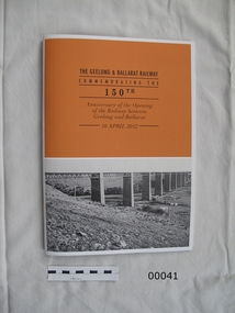
Book, railway, The Geelong & Ballarat Railway, Commemorating the 150th Anniversary of the Opening of the Railway between Geelong and Ballarat - 10 April 2012, 2012
Part of the contents of a souvenir gift bag given to those who rode on the re-enactment train for the 150th anniversary of the Geelong to Ballarat railway on 10 April 2012.A4 sized cardboard covered book, 50 pages. Cover orange with a white 5mm border. The bottom half of the front cover is an early photo of the Moorabool Viaduct.geelong ballarat railway, railway 150th anniversary, michael guiney -
 Orbost & District Historical Society
black and white photographs, second half 20th century
3154.1 is a postcard of the Orbost viaduct over the flooded Snowy River flats. 4153.2 is of a goods train on the viaduct. 3154.3 is of a loaded goods train with the driver at the window. Two men are standing on the plate and there are two workers below where there is some water and flood debris. 3154.4 is of amachine moving flood debris on the rail line. 3154.5 shows flood damage to the viaduct across the Snowy River flats. Two men are driving a dozer.This item is associated with the history of the Orbost-Bairnsdale railway line and therefore reflects the role that the rail line played in the social and economic history of Orbost.Five black / white photographs associated with the Orbost railway line during a flood.orbost-railway east-gippsland -railway orbost-floods -
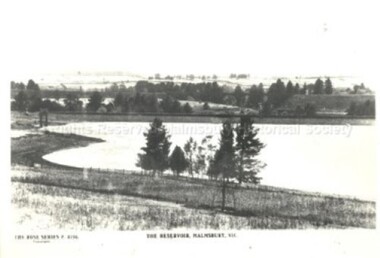 Malmsbury Historical Society
Postcard (Item), Postcard Of The Reservoir Malmsbury Rose Series P4156, Malmsbury c1923
Associated with - Rose Series P4156 Buildings - "Reservoir, Viaduct"