Marysville & District Historical Society
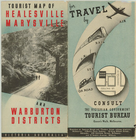
Map (Item) - Tourist Map, Department of Lands & Survey, Tourist Map of Healesville, Marysville and Warburton Districts, 1938
... ...victorian deparment of crown lands and survey...Victorian Department of Crown Lands and Survey, in conjunction with Victorian Railways, in 1938. A tourist map for Healesville, Marysville and Warburton that was produced by the Victorian Department of Crown Lands and Survey, in conjunction with Victorian Railways, in 1938. healesville marysville warburton victoria tourist information tourism map tourist map victorian deparment of crown lands and survey victorian railways betterment and publicity board Compiled by the Department of Lands and Survey, Melbourne
Issued by the Betterment and Publicity Board, Victorian Railways, Melbourne, Victoria. ...
A tourist map for Healesville, Marysville and Warburton that was produced by the Victorian Department of Crown Lands and Survey, in conjunction with Victorian Railways, in 1938.A tourist map for Healesville, Marysville and Warburton that was produced by the Victorian Department of Crown Lands and Survey, in conjunction with Victorian Railways, in 1938.Compiled by the Department of Lands and Survey, Melbourne
Issued by the Betterment and Publicity Board, Victorian Railways, Melbourne, Victoria. May 1938healesville, marysville, warburton, victoria, tourist information, tourism, map, tourist map, victorian deparment of crown lands and survey, victorian railways, betterment and publicity board