Showing 1535 items matching "victorian maps"
-
 Sunshine and District Historical Society Incorporated
Map - Victorian maps of 1856, 1856
... Victorian maps of 1856...Victorian maps of 1856...Victoria Map Photocopied reproductions of Travellers road maps of Victoria 1856 showing Lexton or Burnbank LaTrobe collection State Library of Victoria Victorian maps of 1856 Map Victorian maps of 1856 ...Photocopied reproductions of Travellers road maps of Victoria 1856 showing Lexton or Burnbank LaTrobe collection State Library of Victoriavictoria, map -
 University of Melbourne, Burnley Campus Archives
Plan, Maplist: Catalogue of Victorian maps, 1984
... Maplist: Catalogue of Victorian maps...Maplist: Catalogue of Victorian maps Plan ...Brochure showing all standard series mapping in Victoria available from Map Sales Centre as at October 1984. Includes: Geographic, Geological Planimetric, Aerial Photography, Photo Maps.maps, catalogue -
 Ringwood and District Historical Society
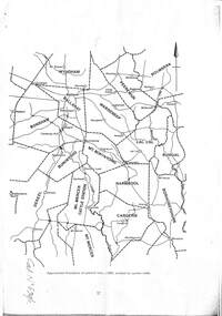
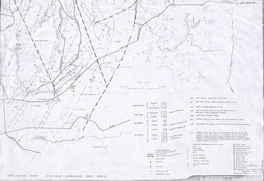
Map - Maps, Geological Map Donvale to Chirnside Park, also Victorian Railways Maps of Hawthorn to Lilydale Line incl Ringwood to East Ringwood - 1881
... Geological Map Donvale to Chirnside Park, also Victorian Railways Maps of Hawthorn to Lilydale Line incl Ringwood to East Ringwood - 1881...Geological Map Donvale to Chirnside Park, also Victorian Railways Maps of Hawthorn to Lilydale Line incl Ringwood to East Ringwood - 1881 Map Maps ...Faint photocopies of sections of larger maps. Geological map includes location of mine shafts circa 1920.Victory Shaft, North Victory Shaft, South Caledonia Shaft, Caledonia Shaft, North Caledonia Shaft, Black Swan Shaft, Reward Shaft, Consols Shaft, Blocks Shaft, Devonshire Shaft, Crown Shaft, Yarra Tunnel Reef Working, Bright's Shaft, Kingwood Antimony Company Shaft (Boardman's Shaft), Southern Shaft. -
 Tatura Irrigation & Wartime Camps Museum
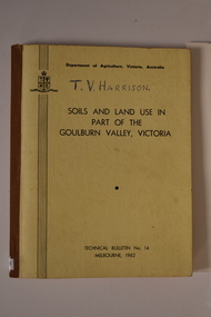
Book, Department of Agriculture Victori, Soil and Land Use in Part of the Goulburn Valley Victoria Technical Bulletin No 14, 1962
... ...Victorian maps...Goulburn Valley soil studies Victoria Victorian maps Mid sized book with soft cover, brown spine with off white cover. ...Mid sized book with soft cover, brown spine with off white cover. Black writing on back and front. Contains maps. Tech Bulletin No 14.non-fictiongoulburn valley, soil studies victoria, victorian maps -
 Victorian Aboriginal Corporation for Languages
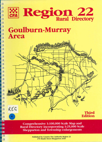
Map, Country Fire Authority, Region 22 rural directory Goulburn-Murray area, 1997
... ...Victorian maps...Victorian Aboriginal Corporation for Languages 33 Saxon Street Brunswick melbourne Goulburn region fire protection emergency services Victorian maps directories maps Region 22 rural directory Goulburn-Murray area Map Country Fire Authority ...mapsgoulburn region, fire protection, emergency services, victorian maps, directories -
Victorian Aboriginal Corporation for Languages
Map, Geographic Data Victoria, Vicmap topographic map index as at June 2000, 2000
... Victorian maps...Victorian Aboriginal Corporation for Languages 33 Saxon Street Brunswick melbourne Victorian maps topographic maps maps Index to Vicmap topographic mapping, including 1:25 000 and 1:50 000 topographic maps, and Outdoor leisure series, compiled by the earlier bodies, Survey &? ...Index to Vicmap topographic mapping, including 1:25 000 and 1:50 000 topographic maps, and Outdoor leisure series, compiled by the earlier bodies, Survey &? Mapping Victoria, etc. Also indexes Royal Australian Survey Corps' 1:50 000 topographic mapping.mapsvictorian maps, topographic maps -
 Victorian Aboriginal Corporation for Languages
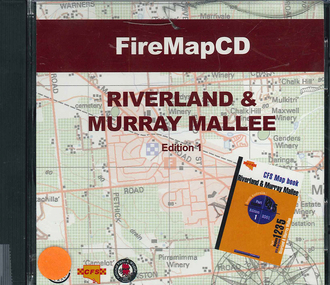
CD-ROM, Country Fire Services South Australia, FireMapCD Riverland &? Murray Mallee, 2001
... ...Victorian maps...Victorian Aboriginal Corporation for Languages 33 Saxon Street Brunswick melbourne fire protection Victorian maps CD-ROM The area covered by this map is the same as the CFS Riverland & Murray Mallee Map Book. ...The area covered by this map is the same as the CFS Riverland & Murray Mallee Map Book. The area covered adjoins the Mount Lofty Ranges map book on the eastern boundary at Murray Bridge, north to Morgan and east to Renmark and the State Border. It extends southwards to join the northern boundary of the Lower South East map book at Padthaway.CD-ROMfire protection, victorian maps -
 Bendigo Historical Society Inc.
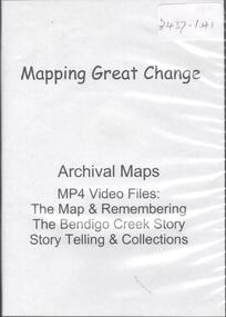
Map - MAPPING GREAT CHANGE
... Map...Victorian Maps...Map Victorian Maps DVD. Mapping Great Change. Archival Maps. ...DVD. Mapping Great Change. Archival Maps. Two copies.map, victorian maps -
 Victorian Aboriginal Corporation for Languages
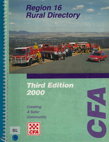
Map, Country Fire Authority, Region 16 rural directory, 2000
... maps...Victorian regional maps...Victorian Aboriginal Corporation for Languages 33 Saxon Street Brunswick melbourne Ararat fire protection emergency services maps Victorian regional maps maps, colour photographs Region 16 rural directory Map Country Fire Authority ...maps, colour photographsararat, fire protection, emergency services, maps, victorian regional maps -
Victorian Aboriginal Corporation for Languages
Book, Melway Publishing, Melway Greater Melbourne street directory : including Geelong, Phillip Island, Healesville, Kinglake, Gisborne, Lorne, Wallan, Bacchus Marsh, Bellarine &? Mornington Peninsulas, 2005
... maps...Victorian street maps...Victorian Aboriginal Corporation for Languages 33 Saxon Street Brunswick melbourne maps Victorian street maps street directories road maps maps Street directory including the wider area surrounding Melbourne. ...Street directory including the wider area surrounding Melbourne.mapsmaps, victorian street maps, street directories, road maps -
Stawell Historical Society Inc
Map, Victorian Geological Map, 1963
... Victorian Geological Map...Victorian Geological Map...Stawell Historical Society Inc 46 Longfield St Stawell grampians Stawell Mining Victorian Geological Map Victorian Geological Map Map ...Victorian Geological Mapstawell, mining -
 Victorian Aboriginal Corporation for Languages
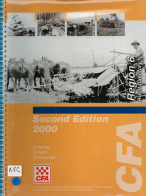
Map, Country Fire Authority, Region 6 rural directory, 2000
... ...Victorian regional maps...Victorian Aboriginal Corporation for Languages 33 Saxon Street Brunswick melbourne Colac Lismore Cressy Lake Corangamite Camperdown Terang Cobden Peterborough Port Campbell Apollo Bay Forrest Victorian regional maps fire protection maps, b&w photographs Region 6 rural directory Map Country Fire Authority ...maps, b&w photographscolac, lismore, cressy, lake corangamite, camperdown, terang, cobden, peterborough, port campbell, apollo bay, forrest, victorian regional maps, fire protection -
 Victorian Aboriginal Corporation for Languages
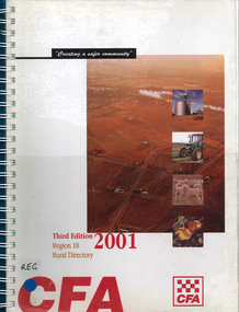
Map, Country Fire Authority, Region 18 rural directory, 2001
... ...Victorian regional maps...Victorian Aboriginal Corporation for Languages 33 Saxon Street Brunswick melbourne Swan Hill Mildura Mallee fire protection emergency services Victorian regional maps Maps, colour photographs Region 18 rural directory Map Country Fire Authority ...Maps, colour photographsswan hill, mildura, mallee, fire protection, emergency services, victorian regional maps -
 Victorian Aboriginal Corporation for Languages
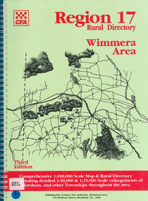
Map, Country Fire Authority, Region 17 rural directory : Wimmera area, 1997
... ...Victorian regional maps...Victorian Aboriginal Corporation for Languages 33 Saxon Street Brunswick melbourne Horsham Wimmera West Wimmera Hindmarsh Yarramback Grampians fire protection emergency services Victorian regional maps maps Region 17 rural directory : Wimmera area Map Country Fire Authority ...mapshorsham, wimmera, west wimmera, hindmarsh, yarramback, grampians, fire protection, emergency services, victorian regional maps -
 Victorian Aboriginal Corporation for Languages
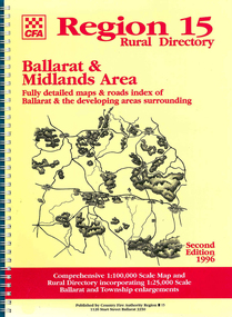
Map, Country Fire Authority, Region 15 rural directory : Ballarat &? Midlands Area : fully detailed maps &? roads index of Ballarat &? the developing areas surrounding, 1996
... ...Victorian regional maps...Victorian Aboriginal Corporation for Languages 33 Saxon Street Brunswick melbourne Ballarat fire protection Victorian regional maps emergency services maps Region 15 rural directory : Ballarat &? ...mapsballarat, fire protection, victorian regional maps, emergency services -
 Victorian Aboriginal Corporation for Languages
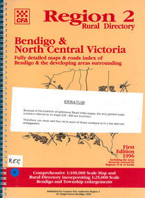
Map, Country Fire Authority, Region 2 rural directory : Bendigo &? North Central Victoria: fully detailed maps &? roads index of Bendigo &? the developing areas surrounding, 1996
... ...Victorian regional maps...Victorian Aboriginal Corporation for Languages 33 Saxon Street Brunswick melbourne Bendigo Loddon fire protection Victorian regional maps directories maps Region 2 rural directory : Bendigo &? ...mapsbendigo, loddon, fire protection, victorian regional maps, directories -
Whitehorse Historical Society Inc.
Map, Directory Maps of the County of Bourke, 1892
... also a complete map of the Colony of Victoria, showing all the Counties, Parishes, Railways and stations to date, and the Mallee Blocks. Lithographed by G.S.B. Bonney for the Victorian...Directory maps of the County of Bourke, containing all the Parishes ... also a complete map of the Colony of Victoria, showing all the Counties, Parishes, Railways and stations to date, and the Mallee Blocks. Lithographed by G.S.B. Bonney for the Victorian...Whitehorse Historical Society Inc. 2-10 Deep Creek Road Mitcham melbourne also a complete map of the Colony of Victoria, showing all the Counties, Parishes, Railways and stations to date, and the Mallee Blocks. Lithographed by G.S.B. Bonney for the Victorian ...Directory maps of the County of Bourke, containing all the Parishes ...Directory maps of the County of Bourke, containing all the Parishes ... also a complete map of the Colony of Victoria, showing all the Counties, Parishes, Railways and stations to date, and the Mallee Blocks. Lithographed by G.S.B. Bonney for the Victorian Shire Map Company. Scale: 40 chains to the inch.Directory maps of the County of Bourke, containing all the Parishes ...maps, victoria. county of bourke, t.r.b. morton & son -
 Victorian Aboriginal Corporation for Languages
Book, Aboriginal Community Elders Service et al, Aboriginal elders' voices : stories of the "tide of history" : Victorian Indigenous elders' life stories &? oral histories, 2003
... maps...Victorian missions and reserves...Victorian Aboriginal Corporation for Languages 33 Saxon Street Brunswick melbourne Wiradjuri Victorian Indigenous elders oral histories Yorta Yorta Dja Dja Wurrung language maps Victorian missions and reserves Lake Condah Framlingham Coranderrk Ramahyuck Lake Tyers Wahgunyah Cummeragunja Moonahcullah Balranald Ebenezer Maloga Acheron maps, colour illustrations, b&w photographs This book is a collection of Victorian Indigenous Elders' life stories and oral histories. ...This book is a collection of Victorian Indigenous Elders' life stories and oral histories. The Elders share their stories in an attempt to ensure that both sides of Australia's history are finally heard. These stories tell of cultural resistance on missions, of defying assimilation laws, of forever moving around to save children from the welfare. They document the development of both fringe and urban communities and work in the Aboriginal rights movement. They clarify the ways in which these experiences have affected the individual authors along with the indigenous population in general. Also included in the book is a brief history and analysis of the legislation, policies, attitudes and strategies that have affected the lives of the authors and their families since colonisation. This aspect provides an historical perspective, encouraging a deeper understanding of the Elders' stories. Reconciliation can only eventuate with an understanding gained from hearing and including the voices of Indigenous Australians. Contents: The writing team Indigenous elders: keepers of knowledge; custodians of land and culture Aboriginal lands Missions and reserves Growing up running from the welfare /? Aunty Olive Jackson Respecting our Elders /? Aunty Lola James If your mother didn't tell you, then your grandmother did! /? Uncles Les Stewart Don't dwell on trouble /? Aunty Audrey Critch There are my people /? Aunty Gwen Nelson We were all cousins, more or less /? Aunty Iris Lovett-Gardiner Aboriginality is about culture, not colour /? Aunty Dianne Phillips Take up the opportunities we struggled to make /? Aunty Frances Gallagher Home /? Aunty Eileen Alberts We were supposed to forget our Aboriginality /? Aunty Gwen Garoni Not enough heart to say sorry? /? Uncle Brian Kennewell-Taylor Learning from indigenous elders: Keeping the traditions, keeping the culture strong; Since time immemorial; Invasion: the tide ran red; The flood of legislation; Stolen children; Cultural resistance: holding on to children traditions and land; Organised resistance: a movement is born; The 1950s: community resistance to race laws; The price of assimilation; The Aboriginal rights movement; After the flood: self-determination; Turning the tide Bibliography Appendix. Cultural custodianship: developing an indigenous methodology.maps, colour illustrations, b&w photographswiradjuri, victorian indigenous elders, oral histories, yorta yorta, dja dja wurrung, language maps, victorian missions and reserves, lake condah, framlingham, coranderrk, ramahyuck, lake tyers, wahgunyah, cummeragunja, moonahcullah, balranald, ebenezer, maloga, acheron -
 Bendigo Historical Society Inc.
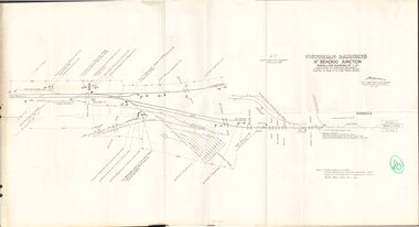
Document - BADHAM COLLECTION: VICTORIAN RAILWAYS MAP - NTH BENDIGO JUNCTION SIGNALLING DIAGRAM NO 4'80
... BADHAM COLLECTION: VICTORIAN RAILWAYS MAP - NTH BENDIGO JUNCTION SIGNALLING DIAGRAM NO 4'80...Victorian railways map: Nth Bendigo junction signalling diagram no 480 showing signal and interlocking arrangements. ...Large paper map, A F chief electrical engineer 9.1.1980. Black ink diagram and writing. Document BADHAM COLLECTION: VICTORIAN RAILWAYS MAP - NTH BENDIGO JUNCTION SIGNALLING DIAGRAM NO 4'80 ...Victorian railways map: Nth Bendigo junction signalling diagram no 480 showing signal and interlocking arrangements. Large paper map, A F chief electrical engineer 9.1.1980. Black ink diagram and writing.document, memo, railway, nth bendigo junction signalling diagram no 4'80 -
Whitehorse Historical Society Inc.
Map, State Electoral Districts, 1937
... Map showing [Victorian] State Electoral Districts, Metropolitan, 1937. ...Map showing [Victorian] State Electoral Districts, Metropolitan, 1937. ...Map showing [Victorian] State Electoral Districts, Metropolitan, 1937.Map showing [Victorian] State Electoral Districts, Metropolitan, 1937. Scale: 40 chains to the inch.Map showing [Victorian] State Electoral Districts, Metropolitan, 1937.electoral boundaries, melbourne, elections -
 Bendigo Historical Society Inc.
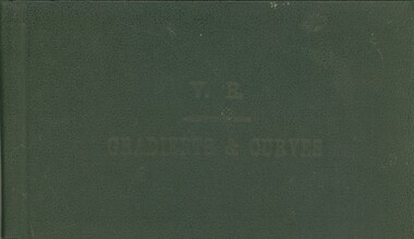
Book - V.R. GRADIENTS & CURVES
... Diagrams of gradients across Victorian rail lines. Maps....Diagrams of gradients across Victorian rail lines. Maps. Book V.R. GRADIENTS & CURVES ...V.R. Gradients & Curves. Publisher H J Green, Government Printer, Melbourne. 203 pages. Diagrams of gradients across Victorian rail lines. Maps.Victorian Railwayscottage, miners -
 Whitehorse Historical Society Inc.
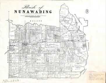
Map - Parish Map, Parish of Nunawading, 1892
... Plate 3 from the "Directory maps of the county of Bourke containing all the parishes, compiled to date from the most authentic municipal records and surveys, compiled and lithographed by G.S.B. Bonney for the Victorian...Whitehorse Historical Society Inc. 2-10 Deep Creek Road Mitcham melbourne Plate 3 from the "Directory maps of the county of Bourke containing all the parishes, compiled to date from the most authentic municipal records and surveys, compiled and lithographed by G.S.B. Bonney for the Victorian ...A map copied from 'Directory maps - parishes and counties' dated 26 Nov 1892. Compiled and lithographed by G.S. Bonney. The map includes roads, railway, stations, names of property owners. It has a scale [ca. 1:31,680] 40 chains to an 1 inch.A map copied from 'Directory maps - parishes and counties' dated 26 Nov 1892. Compiled and lithographed by G.S. Bonney. The map includes roads, railway, stations, names of property owners. It has a scale [ca. 1:31,680] 40 chains to an 1 inch.non-fictionA map copied from 'Directory maps - parishes and counties' dated 26 Nov 1892. Compiled and lithographed by G.S. Bonney. The map includes roads, railway, stations, names of property owners. It has a scale [ca. 1:31,680] 40 chains to an 1 inch.maps, parish of nunawading -
 Whitehorse Historical Society Inc.
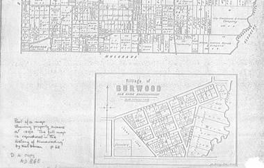
document - Map, Village of Burwood, 1892
... Area bounded by Chapman, Ireland and Evans Streets). Victorian Shire Map. co. 26 November 1892. Scale: 8 chains = 1 inch. ...Map on the village of Burwood. Village of Burwood : old name Ballyshanassy (with southern section of Nunawading). Area bounded by Chapman, Ireland and Evans Streets). Victorian ...Map on the village of Burwood.Village of Burwood : old name Ballyshanassy (with southern section of Nunawading). Area bounded by Chapman, Ireland and Evans Streets). Victorian Shire Map. co. 26 November 1892. Scale: 8 chains = 1 inch. The full map is reproduced in 'The History of Nunawading' by Niall Brennan, p. 62.Map on the village of Burwood.burwood, land settlement -
 Federation University Historical Collection
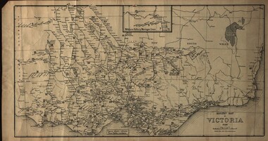
Map, Railway Map of Victoria, 1930
... map...railway...train-lines...victoria...Victorian...Cardboard map of Victorian railway system in 1930. Maps out all train-lines in Victoria and into New South Wales. ...Barker Library (top floor) Mount Helen goldfields map railway train-lines victoria Victorian Railways railway lines Cardboard map of Victorian railway system in 1930. ...Cardboard map of Victorian railway system in 1930. Maps out all train-lines in Victoria and into New South Wales. map, railway, train-lines, victoria, victorian railways, railway lines -
 Bendigo Historical Society Inc.
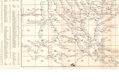
Document - RAILWAY MAP: VICTORIAN LINES 1973
... RAILWAY MAP: VICTORIAN LINES 1973...Railway map - Victorian lines 1973 with list of stations and grid reference for location of stations. ...Document RAILWAY MAP: VICTORIAN LINES 1973 ...Railway map - Victorian lines 1973 with list of stations and grid reference for location of stations. Inset for detail of Ballarat and Melbourne lines and stations. Shows distance from Melbourne (Spencer Street station).railways, bendigo to melbourne, stations -
 Phillip Island and District Historical Society Inc.
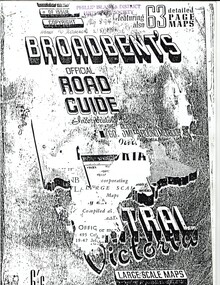
Booklet, Broadbent's Official Road Guide incorporating Central Victoria 55th Edition, About 1951
... In 1963, it changed its name to Broadbent's Road Maps Pty. Ltd. Each Victorian guide contains maps, plans of routes, a detailed description of roads, mileage, hotels, garages, guesthouses, shops etc....In 1963, it changed its name to Broadbent's Road Maps Pty. Ltd. Each Victorian guide contains maps, plans of routes, a detailed description of roads, mileage, hotels, garages, guesthouses, shops etc. ...These are only the pages relevant to Phillip Island from the guide. Broadbent's Official Road Guides Company took over George R. Broadbent's business in 1935. In 1963, it changed its name to Broadbent's Road Maps Pty. Ltd. Each Victorian guide contains maps, plans of routes, a detailed description of roads, mileage, hotels, garages, guesthouses, shops etc.HistoricalFoolscap sized, black and white photocopied pages stapled into booklet.broadbent's guides, guesthouses, shops, hotels, rothsay guesthouse, cowes main garage, co-operative society, hislop's newsagency, wagner's butchery, the nobbies tea rooms -
 Warrnambool and District Historical Society Inc.
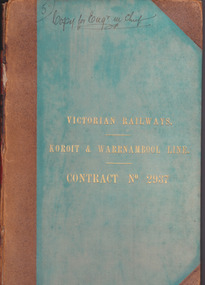
Document - Victorian Railways. Koroit & Warrnambool Line. Contract No. 2937, Circa 1888
... By 1931 every town with a population over 500 had its own railway station. Early Victorian railway maps indicate that the extension from Colac to Warrnambool and then onwards to Koroit, occurred in the period of the 1880’s when the act known as the Octopus act saw a rapid expansion of lines. ...By 1931 every town with a population over 500 had its own railway station. Early Victorian railway maps indicate that the extension from Colac to Warrnambool and then onwards to Koroit, occurred in the period of the 1880’s when the act known as the Octopus act saw a rapid expansion of lines. ...The Victorian Railways began in 1854 and in the first 14 years up to 1868 had managed to complete about 250 miles of track. The next 60 years saw the system expand to nearly 3000 miles. By 1931 every town with a population over 500 had its own railway station. Early Victorian railway maps indicate that the extension from Colac to Warrnambool and then onwards to Koroit, occurred in the period of the 1880’s when the act known as the Octopus act saw a rapid expansion of lines. At the time there was much debate over where the expansion of the lines should take place, with one of the prime considerations for Warrnambool was the impact it would have on its port.The building of the railway to Warrnambool and onward to Koroit was a significant event for the town. Green cloth cover with tan suede corner points and spine. Title printed in gold on front cover. Title printed in gold on red on spine. 92 pages. The contract is printed and includes handwritten entries with specifications.Handwritten on front cover and inside front cover ” Copy for Engr in Chief” .On Page 2 transferred to Allan Reid * 24/1/88 Co Briscoe & Co Little Collins Street, Melbourne.warrnambool, railways, warrnambool to koroit railway, victorian railways contract no 2937 -
 Bendigo Historical Society Inc.
Book - Geographical dictionary
... Brown hardcover book, on the spine: Victorian Gazetteer with map 1865. The first and last pages are advertisements. ...Brown hardcover book, on the spine: Victorian Gazetteer with map 1865. The first and last pages are advertisements. ...The Gazetteer presents an extensive a to z list of Victorian towns and villages, lakes, rivers and creeks, islands, bays, hills and mountains, runs and other localities and features. Entries include latitude and longitude, populations, proximity to other towns, local industries, coach and mail runs, hotels, churches and schools.Bailliere's Victorian Gazetteer and road guide containing the most recent and accurate information as to every place in the colony. Brown hardcover book, on the spine: Victorian Gazetteer with map 1865. The first and last pages are advertisements. The book has 442 pages listing every place in the colony. The map is not included. Compiled by Robert P. Whitworth. Published by Bailliere, Regent Street Unreadable name on first page and the name of F. Houston in blue pen on first page geographic dictionary, colony of victoria -
 Ringwood and District Historical Society
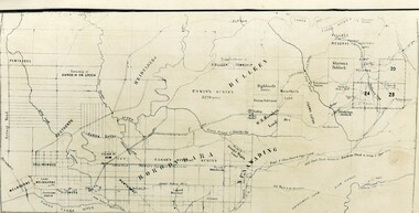
Map - Public Land Sale by Thomas Ham, 2000 Acres for Sale - Crown Sections 20, 23, 24 - Ringwood, Victoria - 1855
... Two 1850s surveyor's maps on cardboard backing showing area from Melbourne extending East beyond Bulleen and Nunawading. Detailed description of lots for sale and navigational directions to the property from Richmond by Thomas Ham, Victorian public servant, map maker, publisher, lithographer and original Ringwood land owner. ...THOMAS HAM. " Two 1850s surveyor's maps on cardboard backing showing area from Melbourne extending East beyond Bulleen and Nunawading. Detailed description of lots for sale and navigational directions to the property from Richmond by Thomas Ham, Victorian public servant, map maker, publisher, lithographer and original Ringwood land owner. ...Two 1850s surveyor's maps on cardboard backing showing area from Melbourne extending East beyond Bulleen and Nunawading. Detailed description of lots for sale and navigational directions to the property from Richmond by Thomas Ham, Victorian public servant, map maker, publisher, lithographer and original Ringwood land owner. Inset map enlarging area between Yarra River and Dandenong Creek, with southern boundary of allotments later forming part of Oban Road, North Ringwood.TRANSCRIPT: "This really valuable Property is now offered to the public for sale, in lots to suit purchasers at the Iow rate of £1 per Acre for 80 acres and upwards, and £1.10s per Acre for any smaller portion. Terms of payment Half Cash, Balance in 6 and 12 months, bearing 8 per cent interest. The Estate is well wooded with Gum, Cherry Tree and Stringy Bark, with Wattle in the valleys of the several creeks. Every lot is Staked and Trenched at the corners marked on the Plan thus - The Surveyor has carefully sub-divided the Property, in order to give every Farm a Creek for Water, Valley for Cultivation, and Hills for House and Grass Paddock. The ROADS have been very carefully laid out so as to give a firm, well drained, and nearly level road to each Homestead. Intending purchasers can readily find the property by the following directions, viz: Start from Richmond Bridge, at Hawthorne, then take the left-hand road to KEW. When at the "Woodman Inn", take the Cotham Road to the right, bearing due east, keep this Road, passing Trainor's "White Horse" Inn, and before you leave the fences, you will see calico bills (see margin) nailed to the Trees on the bush track leading to the Upper Yarra country, follow the Bills till you come to the SOUTH boundary line of the Property, which bears East and West (see Plan) where you will see Bills nailed up "THIS PROPERTY FOR SALE, etc." The Bills from Town lead direct to where Mr. Jull is erecting his Store, and arrangements have been made with him to show the lots to intending purchasers free of charge. At the respective corners of the lots the Bills are nailed up double, with numbers to denote the lot, and that the corner stake is adjacent. Any parties wishing to proceed to the property by way of BULLEEN will find Bills nailed on the Trees, commencing at the NEW INN, at "Wilson's Slip Rail." Keep this Track till you come to the Log Bridge, over the Deep Creek at Bloxhome's Paddock; go through the land now being cleared; keep the track over the hill till you come to an Iron House, you will then be on the property, which Iies to the North and East as per Plan. Follow the Bills till you come to Mr. Jull's Store, etc. etc. Further particulars can be had from the Agent for the Property. THOMAS HAM. " -
 Melbourne Tram Museum
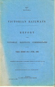
Document - Report, Victorian Railways, Victorian Railways - Report of the Victorian Railways Commissioners, 1925
... Report - stapled and bound within blue light card covers, 118 pages + 10 photo pages + 5 diagram or graph pages + fold out map titled "Victorian Railways - Report of the Victorian Railways Commissioners for the Year ended 30th June 1925". ...Melbourne Tram Museum 8 Wallen Road Hawthorn melbourne Trams tramways Railways Finances Financial Statements Annual Reports Costs Report - stapled and bound within blue light card covers, 118 pages + 10 photo pages + 5 diagram or graph pages + fold out map titled "Victorian Railways - Report of the Victorian Railways Commissioners for the Year ended 30th June 1925". ...Report - stapled and bound within blue light card covers, 118 pages + 10 photo pages + 5 diagram or graph pages + fold out map titled "Victorian Railways - Report of the Victorian Railways Commissioners for the Year ended 30th June 1925". Has a With Compliments slip on the inside front cover. Note: This document is available as a pdf on the Parliament of Victoria website.trams, tramways, railways, finances, financial statements, annual reports, costs