
Showing 202 items matching "wagon road"
-
 Mt Dandenong & District Historical Society Inc.
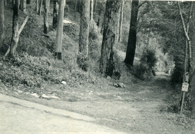
Photograph, The Wagon Road, c1970s
... The Wagon Road......Wagon Road...The old Wagon Road built 1876-1878. This photograph has a detailed inscription on the back handwritten by John Lundy-Clarke in 1974....The Wagon Road. Built 1876 – 8. The first settler’s road in the Ranges as apart from Dray Tracks. ...Jeeves Saddle Kalorama road Wagon Road John Lundy-Clarke The Wagon Road. Built 1876 – 8. ...The old Wagon Road built 1876-1878. This photograph has a detailed inscription on the back handwritten by John Lundy-Clarke in 1974.The Wagon Road. Built 1876 – 8. The first settler’s road in the Ranges as apart from Dray Tracks. Was built through Jeeves Selection, Crown Allotment “C” named “Jeeves saddle” and removed the monopoly held over travel through the Gap. jeeves saddle, kalorama, road, wagon road, john lundy-clarke -
 Mt Dandenong & District Historical Society Inc.
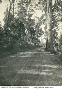
Photograph, Forming Of New Road Kalorama To Olinda, early 1920s
... Wagon...Road...Scene of wagon drawn by two horses on wide dirt road with large trees on side of road. ...This scene is looking towards Montrose down from the intesection of Falls Road. Wagon Road Main Road mt dandenong tourist road Falls Road Horse Scene of wagon drawn by two horses on wide dirt road with large trees on side of road. ...The new Main Road, now Mt Dandenong Tourist Road, was completed in 1926. This scene is looking towards Montrose down from the intesection of Falls Road.Scene of wagon drawn by two horses on wide dirt road with large trees on side of road. Taken just north of Falls Road.wagon, road, main road, mt dandenong tourist road, falls road, horse -
 Port Fairy Historical Society Museum and Archives
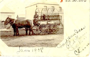
Photograph - Postcard
... road...Wagon...Rabbit Load Jan 1908 James St transport rail road Wagon horses James street rabbits 1908 Jan 1908 - Dad and our dear old horses Darky and Chance- x62-20-006 black and white photograph on card with handwritten greetings Photograph Postcard ...The Port Fairy rabbit factory was mooted on April 1896 by June of the same year The Port Fairy Preserving Company Limited was a registered company. Tenders were called in September and in 1897 a trial preserving run was planned. 5000 pairs of rabbits were being received each day coming by road as depicted in this photograph.Rabbit Load Jan 1908 James Stblack and white photograph on card with handwritten greetings Jan 1908 - Dad and our dear old horses Darky and Chance- x62-20-006 transport, rail, road, wagon, horses, james street, rabbits, 1908 -
 Glenelg Shire Council Cultural Collection
Photograph - Photograph - Portland Harbour, n.d
... Black & white aerial photo of Portland Harbour, also showing Henty Park, canal, railway line & freight wagons, ring road....Port of Portland Authority Archives Port of Portland Archives Portland Harbour Black & white aerial photo of Portland Harbour, also showing Henty Park, canal, railway line & freight wagons, ring road. Photograph Photograph - Portland Harbour ...Port of Portland Authority Archivesport of portland archives, portland harbour -
 Bendigo Historical Society Inc.
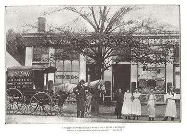
Photograph
... Photograph: Streetscape showing confectionary works (workrooms) in background with horse drawn wagon and 3 staff, 3 women and 3 men on road edge Wagon signed with: ''J Nixon Bendigo Confectionery Works High St''...PHOTOGRAPH Landscape confectonary Horse Drawn Wagon Confectionary J Nixon Photograph: Streetscape showing confectionary works (workrooms) in background with horse drawn wagon and 3 staff, 3 women and 3 men on road edge Wagon signed with: ''J Nixon Bendigo Confectionery Works High St'' Photograph PHOTOGRAPH ...Photograph: Streetscape showing confectionary works (workrooms) in background with horse drawn wagon and 3 staff, 3 women and 3 men on road edge Wagon signed with: ''J Nixon Bendigo Confectionery Works High St''photograph, landscape, confectonary, horse drawn wagon, confectionary, j nixon -
 Clunes Museum
Photograph
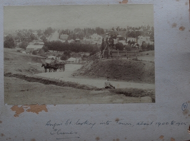
... BLACK AND WHITE PHOTOGRAPH TAKEN FROM BRICK HILL, FACING SOUTH, HORSE DRAWN HAY WAGON AT SIDE OF ROAD. GAS LAMP, POST AND RAIL FENCE. ...local history photography photographs clunes township ANGUS STREET LOOKING INTO TOWN, ABOUT 1900 TO 1905 CLUNES BLACK AND WHITE PHOTOGRAPH TAKEN FROM BRICK HILL, FACING SOUTH, HORSE DRAWN HAY WAGON AT SIDE OF ROAD. GAS LAMP, POST AND RAIL FENCE. ...BLACK AND WHITE PHOTOGRAPH TAKEN FROM BRICK HILL, FACING SOUTH, HORSE DRAWN HAY WAGON AT SIDE OF ROAD. GAS LAMP, POST AND RAIL FENCE. POST OFFICE, TOWN HALL, ES&A BANK,STATE BANKANGUS STREET LOOKING INTO TOWN, ABOUT 1900 TO 1905 CLUNESlocal history, photography, photographs, clunes township -
 Flagstaff Hill Maritime Museum and Village
Tyre Bender, 1884
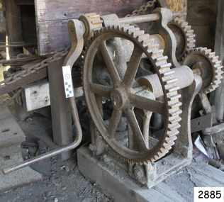
... road...machinery...wagon...wagon wheels, which played an important part in aiding the continuation of daily transport needs that people had at the time, such as farming, personal transport and commercial activities. The machine or tool is locally significant as it was used by a local company in Terang and Mortlake in their blacksmith, wheelwright and garage business. flagstaff hill warrnambool shipwrecked coast flagstaff hill maritime museum maritime museum shipwreck coast flagstaff hill maritime village great ocean road machinery wagon wheel wheelwrights blacksmith steel rim wheels tyre bender tire bender the giant tyre bender henry goodall (1870-1936) terang wheelwright tool blacksmith trade blacksmithing equipment and supplies wagon tyre bender day bros. philadelphia pennsylvania h. goodall & sons of terang terang blacksmith h. goodall & sons pty ltd, mortlake ernie entwistle blacksmith alfred hodgetts radio expert charles goodall john goodall mrs. chas. newton nee goodall “DAY BROS. ...A tyre bender is used to bend and shape metal rims for wooden wagon wheels. This tyre bender’s model first appeared in the Day Bros catalogue in 1884 as the “Giant” model. The catalogue of 1883 only showed a lighter duty model called the “Lion”. It can be assumed that this later “Giant” model was a heavy duty improvement over the 1883 "Lion" and other smaller models which were still being advertised for sale in 1884. The Day Bros foundry, makers of this tyre bender, was operating as the manufacture of wheel right and blacksmith tools and general machinery in the 19th century in the USA and successfully exported their goods all over the world. Wagon tyre benders would have been very common circa 1850-1920, so there were probably many makers over the years. Early on, it would have become clear to the blacksmiths about which designs worked best so, eventually, the various makers would have made similar products to each other. This tyre bender was once used by Harry Goodall of H. Goodall & Sons Pty. Ltd. corner of McKinnon and High Streets, Terang. Victoria. Henry Goodall & Sons Henry Goodall (1870-1936) was proprietor of garages as H. Goodall & Sons Pty. Ltd., at both Terang (McKinnon and High Streets) and Mortlake (Dunlop Street). His business was in operation in at least in 1916 and perhaps well before, considering the date of the tyre bender and its use for wagons with wooden wheels. It was still in operation in 1953, chasing up debtors in Mount Gambier Court. Amongst the employees of H. Goodall & Sons Pty. Ltd. was Ernie Entwistle, a blacksmith (a soldier who died in 1916 ) and Alfred Hodgetts, radio expert (killed in a fatal accident in 1943, when he was in his early 30s ). Henry Goodall was involved in the community as a Justice of Peace, a deputy coroner, President of the Mortlake Hospital, trustee of the Soldiers’ Memorial Hall, and as a prominent Freemason. He and his wife had two sons (Charles and John) and one daughter (Mrs. Chas. Newton, of Skipton). The tyre bender is significant as it demonstrates how blacksmiths or wheelwrights could make new metal rims for wagon wheels for carts, wagons, stage coaches and carriages over a 135 years ago. The machine is a part of our social history as it demonstrates part of the process of making wagon wheels, which played an important part in aiding the continuation of daily transport needs that people had at the time, such as farming, personal transport and commercial activities. The machine or tool is locally significant as it was used by a local company in Terang and Mortlake in their blacksmith, wheelwright and garage business. Steel tyre bender mounted on timber base, used for wagon wheel steel rims. Made from cast iron and steel, double geared with four cogs to unite the upper and lower steel rollers. There are adjustable guide collars to keep the iron in line while it is being bent. It can also be used with two cranks for heavy duty work utilising the use to two operators. It is the Giant model, made in 1884 by Day Bros. of Philadelphia. This tyre bender once belonged to Harry Goodall & Sons, blacksmith's of Terang. Victoria. “DAY BROS. PHILAP. PA” cast into the side of machineflagstaff hill, warrnambool, shipwrecked coast, flagstaff hill maritime museum, maritime museum, shipwreck coast, flagstaff hill maritime village, great ocean road, machinery, wagon wheel, wheelwrights, blacksmith, steel rim wheels, tyre bender, tire bender, the giant tyre bender, henry goodall (1870-1936), terang, wheelwright tool, blacksmith trade, blacksmithing equipment and supplies, wagon tyre bender, day bros. philadelphia pennsylvania, h. goodall & sons of terang, terang blacksmith, h. goodall & sons pty ltd, mortlake, ernie entwistle blacksmith, alfred hodgetts radio expert, charles goodall, john goodall, mrs. chas. newton nee goodall -
 Flagstaff Hill Maritime Museum and Village
Wagon, circa 1850s
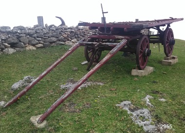
... He resided at Marramook in Hawkesdale and later moved to Vaucluse in Hopetoun Road Warrnambool, where he died in 1920 at the age of 87. The Wagon is significant locally and state wide for its association with Augustus Bostock who was involved in many aspects of life in the Western District of Victoria, racing, cricket, and social activities to name a few. ...Bostock & Manifold were all from pioneering families in the Western District of Victoria almost from the time of settlement. Family history: The Bostock family were prominent in Warrnambool from the 1850s to the 1880s. Patriarch Robert Bostock had in 1813 been transported to Sydney from Sierra Leone for having 'felonious traded in slaves' and sentenced to 14 years transportation. He moved to Tasmania in 1821 where he died in 1847. A number of his children came to Port Phillip. Edward Robert Bostock held the Jellabad run from 1849 to 1853. George Bostock (1826-1858) was a Warrnambool Shire Councillor in 1856. Thomas Edward Bostock (1828-1874) was a Shire Councillor in the late 1860s. Augustus Bostock (1833-1920) lived in Warrnambool. Augustus Bostock was the 9th child of Robert and Rachael Bostock of Vaucluse Epping Forest, Van Diemen's Land. He was only 4 years old when his mother died. He was inspired by his father to seek his fortune in the Western District of Victoria. He arrived around 1850. He married Margaret Aitkin in July 1865. Augustus owned several properties in the district and leased others. He sat on the court of Warrnambool, Mortlake or Hexham as required. He resided at Marramook in Hawkesdale and later moved to Vaucluse in Hopetoun Road Warrnambool, where he died in 1920 at the age of 87. The Wagon is significant locally and state wide for its association with Augustus Bostock who was involved in many aspects of life in the Western District of Victoria, racing, cricket, and social activities to name a few. Bostock & Manifold were all from pioneering families in the Western District of Victoria almost from the time of settlement. The wagon is significant for its historical and economic association with the local Warrnambool business of Manifold & Bostock. These men had leased and owned vast tracts of land and operated businesses around the district together at various times often associated with the farming industry. One example is the Manifold & Bostock store and flour mill from which the wagon dray is believed to have been associated with for the delivery of goods. Their flour mill began operation in 1850 in 7-17 Stanley St South Warrnambool and was known as “Jetty Mills” Manifold and Bostock in 1858 purchased the Mill from John and G Elliot (brothers) with half an acre of ground and a cottage for £1600. It appears addresses of the company changed over the years as the town grew. These are listed in “Jones, Lewis & Peggy flour mills of Victoria” showing the company operating from, Fairy Street and later at the Merri River near the cutting, known as Banyan and Merri Streets. The company ceased trading in 1870. The Wagon Dray is also an example of agricultural freight and general transportation during the 1800 and 1900 century.A four-wheeled wooden horse-drawn wagon with flat top described as a Wagon Dray in historical writings. Painted brown and black. The wagon has rear brakes, wooden, operated from a metal handle at the front of the Wagon. Front wheels are attached to a turnstile to allow easy turning of the wagon. This flat-topped, horse driven, four-wheeled Wagon was used for cartage by the business of Manifold & Bostock, Warrnambool. The original sign writing of the wagon is obscured or painted over. There is a feint mark of lettering to the sides and back edges of the cart Manifold & Bostock. "Manifold and Bostock" very feintflagstaff hill, warrnambool, shipwrecked-coast, flagstaff-hill, flagstaff-hill-maritime-museum, maritime-museum, flagstaff-hill-maritime-village, cartage, manifold and bostock of warrnambool, manifold family of western victoria, bostock family of western victoria, four wheeled wagon, wagon, horse drawn wagon, farm wagon, aitkin, aitkin bostock manifold, dray, aitkin family, cart, aitken, flour mill -
 The Beechworth Burke Museum
Photograph, c1900
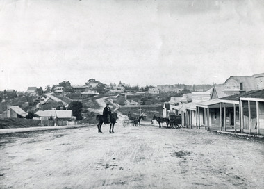
... road in Beechworth. He is outside a row of businesses, including R.McKenzie & Sons Grain Store and Mackenzie Family Store (Wholesale & Retail Est. 1855), along a sloping hill. Behind the main rider are a parked horse and laden two-wheeled cart backed up directly outside the grain store's verandah, and another man is driving a horse and four-wheeled wagon forward towards them. ...road in Beechworth. He is outside a row of businesses, including R.McKenzie & Sons Grain Store and Mackenzie Family Store (Wholesale & Retail Est. 1855), along a sloping hill. Behind the main rider are a parked horse and laden two-wheeled cart backed up directly outside the grain store's verandah, and another man is driving a horse and four-wheeled wagon forward towards them. ...Believed to have been taken sometime between 1858 and 1908, featuring a man with moustache, dressed in hat and long riding coat, seated on a bob-tailed horse, is stopped in the middle of a wide dirt road in Beechworth. He is outside a row of businesses, including R.McKenzie & Sons Grain Store and Mackenzie Family Store (Wholesale & Retail Est. 1855), along a sloping hill. Behind the main rider are a parked horse and laden two-wheeled cart backed up directly outside the grain store's verandah, and another man is driving a horse and four-wheeled wagon forward towards them. At the bottom of the hill is a bridge (Newtown Bridge) with forked road on the far side, leading to a number of houses on both sides of another hill. This image is looking down Bridge Street, Newtown, Beechworth and across to Ford Street (left) and High Street (right). Road-making was a focus of town development during the 1850s, and the wide streets were created on the instructions of the surveyor-general to be between sixty-six and ninety-nine feet wide to give the town a pleasing aspect.This photograph is important in showing the development and expansion of the various businesses and buildings in Bridge Street of Newtown, Beechworth. Black and white rectangular photograph printed on paperReverse: 6980/ PH 118/ 1998.00059/beechworth, new town, newtown, newtown beechworth, local business, mackenzie family store, mackenzie's family store, mackenzie, grain store, bridge, ford steet, high street, colonial australia, australian gold rushes, mining technology, beechworth historic district, indigo gold trail, migration, indigo shire, mckenzie and sons grainstore, mckenzie family store, mckenzie, newtown bridge -
 Marysville & District Historical Society
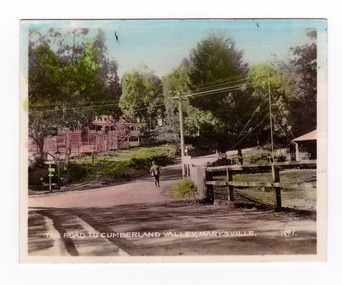
Photograph (item) - Colour tinted photograph, Valentine Publishing Co. Pty. Ltd, The Road to Cumberland Valley, Marysville. No. 1, 1923-1963
... The Marysville-Woods Point Road was originally part of the Yarra Track, constructed in the early 1860s to provide access between Healesville and the Woods Point Goldfields. Despite the steep terrain and engineering difficulties, the Yarra Track soon became a busy route used by pack horses, horse-drawn drays, and wagons. ...An early colour tinted photograph of the intersection of the Buxton Marysville Road and the Marysville-Wood's Point Road.An early photograph of the Buxton Marysville Road and the Marysville-Wood's Point Road intersection. The Marysville-Buxton Road joins the Maroondah Highway which leads to Alexandra. The Marysville-Woods Point Road was originally part of the Yarra Track, constructed in the early 1860s to provide access between Healesville and the Woods Point Goldfields. Despite the steep terrain and engineering difficulties, the Yarra Track soon became a busy route used by pack horses, horse-drawn drays, and wagons. Today this sealed mountain road is a popular scenic drive between Marysville and Warburton. On the right of the photograph can be seen 'The Crossways Hotel' which is circa 1920 and one of the oldest buildings still standing in Marysville. 'The Crossways Hotel' survived the 2009 Black Saturday bushfires, through the efforts of the owner using buckets of water from the nearby Steavenson River. In the background can be seen the Poontawan Guest House which later became the Marysville Chalet Guest House which was on the site of the original Steavenson's Hotel. That guest house no longer exists and the Christ Church stands on the land where the guest house once stood. This photograph was published by the Valentine Publishing Co Pty. Ltd as a souvenir of Marysville.marysville, victoria, marysville chalet guest house, crossways hotel, christ church marysville, poontawan guest house, steavenson's hotel, valentine publishing co, souvenir, yarra track, wood's point road, mining, buxton-marysville road, marysville-wood's point road, maroondah highway, alexandra -
 Marysville & District Historical Society
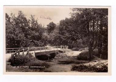
Photograph (item) - Black and white photograph, Valentine Publishing Co. Pty. Ltd, The Old Ford, Marysville No.9, 1923-1963
... The Marysville-Woods Point Road was originally part of the Yarra Track, constructed in the early 1860s to provide access between Healesville and the Woods Point Goldfields. Despite the steep terrain and engineering difficulties, the Yarra Track soon became a busy route used by pack horses, horse-drawn drays, and wagons. ...An early black and white photograph of the old ford in Marysville, Victoria.An early photograph of the bridge at the end of the main street in Marysville which is near the Buxton-Marysville Road and the Marysville-Wood's Point Road intersection. The Marysville-Buxton Road joins the Maroondah Highway which leads to Alexandra. The Marysville-Woods Point Road was originally part of the Yarra Track, constructed in the early 1860s to provide access between Healesville and the Woods Point Goldfields. Despite the steep terrain and engineering difficulties, the Yarra Track soon became a busy route used by pack horses, horse-drawn drays, and wagons. Today this sealed mountain road is a popular scenic drive between Marysville and Warburton. This photograph was published by the Valentine Publishing Co Pty. Ltd as a souvenir of Marysville.marysville, victoria, valentine publishing co, souvenir, buxton-marysville road, marysville-wood's point road, maroondah highway, alexandra, yarra track, mining -
 Marysville & District Historical Society
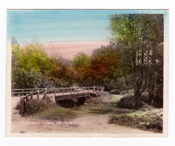
Photograph (item) - Colour tinted photograph, Valentine Publishing Co. Pty. Ltd, The Old Ford, Marysville No.9, 1923-1963
... The Marysville-Woods Point Road was originally part of the Yarra Track, constructed in the early 1860s to provide access between Healesville and the Woods Point Goldfields. Despite the steep terrain and engineering difficulties, the Yarra Track soon became a busy route used by pack horses, horse-drawn drays, and wagons. ...An early colour tinted photograph of the old ford in Marysville, Victoria. This photograph was published by the Valentine Publishing Co Pty. Ltd. as a souvenir of Marysville.An early photograph of the bridge at the end of the main street in Marysville which is near the Buxton-Marysville Road and the Marysville-Wood's Point Road intersection. The Marysville-Buxton Road joins the Maroondah Highway which leads to Alexandra. The Marysville-Woods Point Road was originally part of the Yarra Track, constructed in the early 1860s to provide access between Healesville and the Woods Point Goldfields. Despite the steep terrain and engineering difficulties, the Yarra Track soon became a busy route used by pack horses, horse-drawn drays, and wagons. Today this sealed mountain road is a popular scenic drive between Marysville and Warburton. This photograph was published by the Valentine Publishing Co Pty. Ltd as a souvenir of Marysville.marysville, victoria, valentine publishing co, souvenir, buxton-marysville road, marysville-wood's point road, maroondah highway, alexandra, yarra track, mining -
 Marysville & District Historical Society
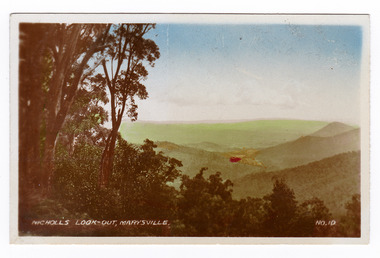
Photograph (item) - Colour tinted photograph, Valentine Publishing Co. Pty. Ltd, Nicoll's Lookout, Marysville No.10, 1923-1963
... The Marysville-Woods Point Road was originally part of the Yarra Track, constructed in the early 1860s to provide access between Healesville and the Woods Point Goldfields. Despite the steep terrain and engineering difficulties, the Yarra Track soon became a busy route used by pack horses, horse-drawn drays, and wagons. ...An early colour tinted photograph of Nicholl's Look-out near Marysville in Victoria. This photograph was published by the Valentine Publishing Co Pty. Ltd. as a souvenir of Marysville.An early colour tinted photograph of Nicholl's Look-out near Marysville in Victoria. This lookout is situated on the Marysville-Wood's Point Road. The Marysville-Woods Point Road was originally part of the Yarra Track, constructed in the early 1860s to provide access between Healesville and the Woods Point Goldfields. Despite the steep terrain and engineering difficulties, the Yarra Track soon became a busy route used by pack horses, horse-drawn drays, and wagons. Today this sealed mountain road is a popular scenic drive between Marysville and Warburton. This photograph was published by the Valentine Publishing Co Pty. Ltd. as a souvenir of Marysville.marysville, victoria, valentine publishing co, souvenir, nicholl's look-out, mining, yarra track -
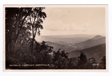 Marysville & District Historical Society
Photograph (item) - Black and white photograph, Valentine Publishing Co. Pty. Ltd, Nicoll's Lookout, Marysville No.10, 1923-1963
... The Marysville-Woods Point Road was originally part of the Yarra Track, constructed in the early 1860s to provide access between Healesville and the Woods Point Goldfields. Despite the steep terrain and engineering difficulties, the Yarra Track soon became a busy route used by pack horses, horse-drawn drays, and wagons. ...An early black and white photograph of Nicholl's Look-out near Marysville in Victoria.An early black and white photograph of Nicholl's Look-out near Marysville in Victoria. This lookout is situated on the Marysville-Wood's Point Road. The Marysville-Woods Point Road was originally part of the Yarra Track, constructed in the early 1860s to provide access between Healesville and the Woods Point Goldfields. Despite the steep terrain and engineering difficulties, the Yarra Track soon became a busy route used by pack horses, horse-drawn drays, and wagons. Today this sealed mountain road is a popular scenic drive between Marysville and Warburton. This photograph was published by the Valentine Publishing Co Pty. Ltd. as a souvenir of Marysville.marysville, victoria, valentine publishing co, souvenir, nicholl's look-out, mining, yarra track -
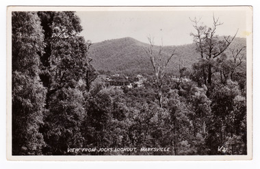 Marysville & District Historical Society
Postcard (item) - Black and white postcard, Valentine Publishing Co. Pty. Ltd, View From Jock's Lookout, Marysville. V. 21, 1923-1963
... The Marysville-Woods Point Road was originally part of the Yarra Track, constructed in the early 1860s to provide access between Healesville and the Woods Point Goldfields. Despite the steep terrain and engineering difficulties, the Yarra Track soon became a busy route used by pack horses, horse-drawn drays, and wagons. ...An early black and white photograph of the view from Jock's Lookout of Marysville in Victoria. An early black and white photograph of the view from Jock's Lookout of Marysville in Victoria. Jock's Lookout is situated on the Marysville-Wood's Point Road. The Marysville-Woods Point Road was originally part of the Yarra Track, constructed in the early 1860s to provide access between Healesville and the Woods Point Goldfields. Despite the steep terrain and engineering difficulties, the Yarra Track soon became a busy route used by pack horses, horse-drawn drays, and wagons. Today this sealed mountain road is a popular scenic drive between Marysville and Warburton. This postcard was published by the Valentine Publishing Co. Pty. Ltd. as a souvenir of Marysville.VALENTINE'S/ POST CARD/ A GENUINE PHOTOGRAPHjock's lookout, marysville, victoria, postcard, valentine publishing co, souvenir, marysville-wood's point road, yarra track, mining, warburton -
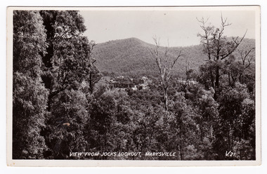 Marysville & District Historical Society
Postcard (item) - Black and white postcard, Valentine Publishing Co. Pty. Ltd, View From Jock's Lookout, Marysville. V. 21, 1923-1963
... The Marysville-Woods Point Road was originally part of the Yarra Track, constructed in the early 1860s to provide access between Healesville and the Woods Point Goldfields. Despite the steep terrain and engineering difficulties, the Yarra Track soon became a busy route used by pack horses, horse-drawn drays, and wagons. ...An early black and white photograph of the view from Jock's Lookout of Marysville in Victoria.An early black and white photograph of the view from Jock's Lookout of Marysville in Victoria. Jock's Lookout is situated on the Marysville-Wood's Point Road. The Marysville-Woods Point Road was originally part of the Yarra Track, constructed in the early 1860s to provide access between Healesville and the Woods Point Goldfields. Despite the steep terrain and engineering difficulties, the Yarra Track soon became a busy route used by pack horses, horse-drawn drays, and wagons. Today this sealed mountain road is a popular scenic drive between Marysville and Warburton. This postcard was published by the Valentine Publishing Co. Pty. Ltd. as a souvenir of Marysville.VALENTINE'S/ POST CARD/ A GENUINE PHOTOGRAPHjock's lookout, marysville, victoria, postcard, valentine publishing co, souvenir, marysville-wood's point road, yarra track, mining, warburton -
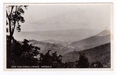 Marysville & District Historical Society
Postcard (item) - Black and white postcard, Valentine Publishing Co. Pty. Ltd, View From Nicholl's Lookout, Marysville. V. 43, 1923-1963
... The Marysville-Woods Point Road was originally part of the Yarra Track, constructed in the early 1860s to provide access between Healesville and the Woods Point Goldfields. Despite the steep terrain and engineering difficulties, the Yarra Track soon became a busy route used by pack horses, horse-drawn drays, and wagons. ...An early black and white photograph of the view of Marysville in Victoria taken from Nicholl's Lookout.An early black and white photograph of the view of Marysville in Victoria taken from Nicholl's Lookout. This lookout is situated on the Marysville-Wood's Point Road. The Marysville-Woods Point Road was originally part of the Yarra Track, constructed in the early 1860s to provide access between Healesville and the Woods Point Goldfields. Despite the steep terrain and engineering difficulties, the Yarra Track soon became a busy route used by pack horses, horse-drawn drays, and wagons. Today this sealed mountain road is a popular scenic drive between Marysville and Warburton. This postcard was published by the Valentine Publishing Co Pty. Ltd. as a souvenir of Marysville.VALENTINE'S/ POST CARD/ A GENUINE PHOTOGRAPHmarysville, nicholl's lookout, victoria, postcard, valentine publishing co, souvenir -
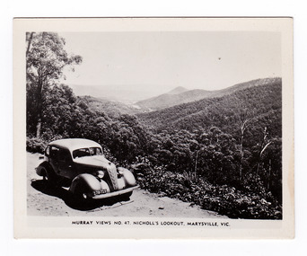 Marysville & District Historical Society
Photograph (item) - Black and white photograph, Murray Views, Murray Views No. 47. Nicholl's Lookout, Marysville, Vic, Post 1929
... The Marysville-Woods Point Road was originally part of the Yarra Track, constructed in the early 1860s to provide access between Healesville and the Woods Point Goldfields. Despite the steep terrain and engineering difficulties, the Yarra Track soon became a busy route used by pack horses, horse-drawn drays, and wagons. ...An early black and white photograph of the view of Marysville taken from Nicholl's Lookout.An early black and white photograph of the view of Marysville taken from Nicholl's Lookout. Nicholl's Lookout is situated on the Marysville-Wood's Point Road. The Marysville-Woods Point Road was originally part of the Yarra Track, constructed in the early 1860s to provide access between Healesville and the Woods Point Goldfields. Despite the steep terrain and engineering difficulties, the Yarra Track soon became a busy route used by pack horses, horse-drawn drays, and wagons. Today this sealed mountain road is a popular scenic drive between Marysville and Warburton. This photograph was produced by Murray Views in Gympie, Queensland as a souvenir of Marysville. nicholl's lookout, marysville, victoria, photograph, murray views, souvenir, marysville-wood's point road, yarra track, mining, warburton -
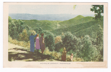 Marysville & District Historical Society
Postcard (item) - Colour tinted postcard, Nucolorvue Productions, Nicholl's Lookout, Marysville, 1950's
... The Marysville-Woods Point Road was originally part of the Yarra Track, constructed in the early 1860s to provide access between Healesville and the Woods Point Goldfields. Despite the steep terrain and engineering difficulties, the Yarra Track soon became a busy route used by pack horses, horse-drawn drays, and wagons. ...An early colour photograph of the view of Marysville in Victoria taken from Nicholl's Lookout.An early colour photograph of the view of Marysville in Victoria taken from Nicholl's Lookout. Nicholl's Lookout is situated on the Marysville-Wood's Point Road. The Marysville-Woods Point Road was originally part of the Yarra Track, constructed in the early 1860s to provide access between Healesville and the Woods Point Goldfields. Despite the steep terrain and engineering difficulties, the Yarra Track soon became a busy route used by pack horses, horse-drawn drays, and wagons. Today this sealed mountain road is a popular scenic drive between Marysville and Warburton. This postcard was produced by Nucolorvue Productions in Elwood, Victoria as a souvenir of Marysville.POST CARD NUCOLORVUE PRODUCTIONS, ELWOOD, VICTORIAnicholl's lookout, marysville, victoria, nucolorvue productions, postcard, souvenir, marysville-wood's point road, yarra track, mining, warburton -
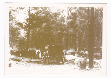 Marysville & District Historical Society
Postcard (item) - Black and white postcard, Marysville & District Historical Society Inc, Bullock Teams at the Dump, Woods Point Road, 1993
... The Marysville-Woods Point Road was originally part of the Yarra Track, constructed in the early 1860s to provide access between Healesville and the Woods Point Goldfields. Despite the steep terrain and engineering difficulties, the Yarra Track soon became a busy route used by pack horses, horse-drawn drays, and wagons. ...A black and white photograph of bullock teams at the Log Dump at on the Wood's Point Road.A black and white photograph of bullock teams at the Dump at on the Wood's Point Road. The Marysville-Woods Point Road was originally part of the Yarra Track, constructed in the early 1860s to provide access between Healesville and the Woods Point Goldfields. Despite the steep terrain and engineering difficulties, the Yarra Track soon became a busy route used by pack horses, horse-drawn drays, and wagons. Today this sealed mountain road is a popular scenic drive between Marysville and Warburton. This postcard was produced by the Marysville Historical Society as a souvenir of Marysville.YESTERYEAR POSTCARDS AFFIX/ STAMP/ HERE BULLOCK TEAMS AT THE DUMP,/ WOODS POINT ROAD. C Marysville Historical Society, 1993marysville, bullock teams, woods point road, victoria, marysville historical society, postcard, souvenir, yesteryear postcards, marysville-wood's point road, yarra track, healesville, mining, timber mills, warburton -
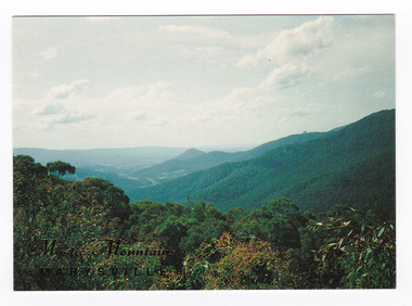 Marysville & District Historical Society
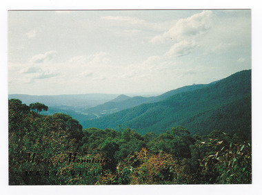
Postcard (item) - Colour postcard, Nucolorvue Productions Pty. Ltd, Mystic Mountains-Marysville, Pre 2009
... The Marysville-Woods Point Road was originally part of the Yarra Track, constructed in the early 1860s to provide access between Healesville and the Woods Point Goldfields. Despite the steep terrain and engineering difficulties, the Yarra Track soon became a busy route used by pack horses, horse-drawn drays, and wagons. ...A colour photograph of the view of the mountains surrounding Marysville in Victoria from Nicholl's Lookout.A colour photograph of the view of the mountains surrounding Marysville in Victoria from Nicholl's Lookout. The mountains surrounding Marysville are known as the Mystic Mountains and Nicoll's Lookout is on the Marysville-Wood's Point Road. The Marysville-Woods Point Road was originally part of the Yarra Track, constructed in the early 1860s to provide access between Healesville and the Woods Point Goldfields. Despite the steep terrain and engineering difficulties, the Yarra Track soon became a busy route used by pack horses, horse-drawn drays, and wagons. Today this sealed mountain road is a popular scenic drive between Marysville and Warburton. This postcard was produced by Nucolorvue Productions in Elwood, Victoria as a souvenir of Marysville.This postcard was produced by Nucolorvue Productions Pty. Ltd. as a souvenir of Marysville.NICHOLS LOOKOUT/ Marysville Victoria NU-COLOR-VUE/ AUSTRALIA'S NATIONAL POSTCARD COMPANY AFFIX/ STAMP/ HERE/ 17MA019/ NCV 9603 POSTCODE COPYRIGHT/ Nucolorvue Productions Pty. Ltd.,/ Telephone: (03) 560-1788/ Made in Australiamarysville, mystic mountains, nicholl's lookout, victoria, nucolorvue productions, postcard, souvenir, marysville-wood's point road, yarra track, healesville, mining, warburton -
 Marysville & District Historical Society
Postcard (item) - Colour postcard, Nucolorvue Productions Pty. Ltd, Mystic Mountains-Marysville, Pre 2009
... The Marysville-Woods Point Road was originally part of the Yarra Track, constructed in the early 1860s to provide access between Healesville and the Woods Point Goldfields. Despite the steep terrain and engineering difficulties, the Yarra Track soon became a busy route used by pack horses, horse-drawn drays, and wagons. ...A colour photograph of the view of the mountains surrounding Marysville in Victoria from Nicholl's Lookout.A colour photograph of the view of the mountains surrounding Marysville in Victoria from Nicholl's Lookout. The mountains surrounding Marysville are known as the Mystic Mountains and Nicoll's Lookout is on the Marysville-Wood's Point Road. The Marysville-Woods Point Road was originally part of the Yarra Track, constructed in the early 1860s to provide access between Healesville and the Woods Point Goldfields. Despite the steep terrain and engineering difficulties, the Yarra Track soon became a busy route used by pack horses, horse-drawn drays, and wagons. Today this sealed mountain road is a popular scenic drive between Marysville and Warburton. This postcard was produced by Nucolorvue Productions in Elwood, Victoria as a souvenir of Marysville.This postcard was produced by Nucolorvue Productions Pty. Ltd. as a souvenir of Marysville.NICHOLS LOOKOUT/ Marysville Victoria NU-COLOR-VUE/ AUSTRALIA'S NATIONAL POSTCARD COMPANY AFFIX/ STAMP/ HERE/ 17MA019/ NCV 9603 POSTCODE COPYRIGHT/ Nucolorvue Productions Pty. Ltd.,/ Telephone: (03) 560-1788/ Made in Australiamarysville, mystic mountains, nicholl's lookout, victoria, nucolorvue productions, postcard, souvenir, marysville-wood's point road, yarra track, healesville, mining, warburton -
 Marysville & District Historical Society
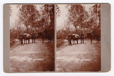
Photograph (Item) - Black and white bi-focal image, Unknown
... The Marysville-Woods Point Road was originally part of the Yarra Track, constructed in the early 1860s to provide access between Healesville and the Woods Point Goldfields. Despite the steep terrain and engineering difficulties, the Yarra Track soon became a busy route used by pack horses, horse-drawn drays, and wagons. ...An early black and white bi-focal image of men and packhorses on the Marysville-Wood's Point Road in Marysville in Victoria.An early black and white bi-focal image of men and packhorses on the Marysville-Wood's Point Road in Marysville in Victoria. This is now known as the Marysville-Wood's Point Road. The Marysville-Woods Point Road was originally part of the Yarra Track, constructed in the early 1860s to provide access between Healesville and the Woods Point Goldfields. Despite the steep terrain and engineering difficulties, the Yarra Track soon became a busy route used by pack horses, horse-drawn drays, and wagons. Today this sealed mountain road is a popular scenic drive between Marysville and Warburton.Packhorses on Wood'spoint Road/ Marysville/ Victoriapackhorses, wood's point road, marysville-wood's point road, marysville, victoria, yarra track, healesville, wood's point goldfields, warburton -
Marysville & District Historical Society
Document (Item) - Newspaper article, The Argus, New Tourist Road. Marysville to Wood's Point Magnificent Forest Scenery, 02-1924
... The Marysville-Woods Point Road was originally part of the Yarra Track, constructed in the early 1860s to provide access between Healesville and the Woods Point Goldfields. Despite the steep terrain and engineering difficulties, the Yarra Track soon became a busy route used by pack horses, horse-drawn drays, and wagons. ...A newspaper article regarding the opening of the Marysville-Wood's Point Road in February 1924.A newspaper article regarding the opening of the Marysville-Wood's Point Road in February 1924. The Marysville-Woods Point Road was originally part of the Yarra Track, constructed in the early 1860s to provide access between Healesville and the Woods Point Goldfields. Despite the steep terrain and engineering difficulties, the Yarra Track soon became a busy route used by pack horses, horse-drawn drays, and wagons. Today this sealed mountain road is a popular scenic drive between Marysville and Warburton.marysville-wood's point road, yarra track, healesville, wood's point goldfields, warburton, the argus -
 Marysville & District Historical Society
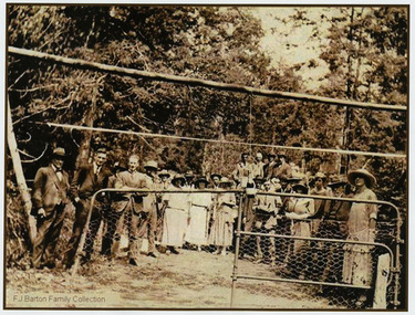
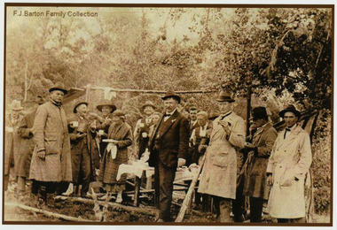
Photograph (Item) - Black and white photograph, 05-02-1924
... The Marysville-Woods Point Road was originally part of the Yarra Track, constructed in the early 1860s to provide access between Healesville and the Woods Point Goldfields. Despite the steep terrain and engineering difficulties, the Yarra Track soon became a busy route used by pack horses, horse-drawn drays, and wagons. ...An early black and white photograph of the ceremonial re-opening of the Marysville-Wood's Point Road in 1924.An early black and white photograph of the ceremonial re-opening of the Marysville-Wood's Point Road in 1924. The Marysville-Woods Point Road was originally part of the Yarra Track, constructed in the early 1860s to provide access between Healesville and the Woods Point Goldfields. Despite the steep terrain and engineering difficulties, the Yarra Track soon became a busy route used by pack horses, horse-drawn drays, and wagons. Today this sealed mountain road is a popular scenic drive between Marysville and Warburton.F.J. Barton Family Collectionmarysville-wood's point road, marysville, wood's point goldfields, healesville, yarra track, warburton -
 Marysville & District Historical Society
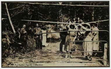
Photograph (Item) - Black and white photograph, 05-02-1924
... The Marysville-Woods Point Road was originally part of the Yarra Track, constructed in the early 1860s to provide access between Healesville and the Woods Point Goldfields. Despite the steep terrain and engineering difficulties, the Yarra Track soon became a busy route used by pack horses, horse-drawn drays, and wagons. ...An early black and white photograph of the ceremonial re-opening of the Marysville-Wood's Point Road in 1924.An early black and white photograph of the ceremonial re-opening of the Marysville-Wood's Point Road in 1924. The Marysville-Woods Point Road was originally part of the Yarra Track, constructed in the early 1860s to provide access between Healesville and the Woods Point Goldfields. Despite the steep terrain and engineering difficulties, the Yarra Track soon became a busy route used by pack horses, horse-drawn drays, and wagons. Today this sealed mountain road is a popular scenic drive between Marysville and Warburton.F.J. Barton Family Collectionmarysville-wood's point road, marysville, wood's point goldfields, healesville, yarra track, warburton -
 Marysville & District Historical Society
Photograph (Item) - Black and white photograph, 05-02-1924
... The Marysville-Woods Point Road was originally part of the Yarra Track, constructed in the early 1860s to provide access between Healesville and the Woods Point Goldfields. Despite the steep terrain and engineering difficulties, the Yarra Track soon became a busy route used by pack horses, horse-drawn drays, and wagons. ...An early black and white photograph of the ceremonial re-opening of the Marysville-Wood's Point Road in 1924.An early black and white photograph of the ceremonial re-opening of the Marysville-Wood's Point Road in 1924. The Marysville-Woods Point Road was originally part of the Yarra Track, constructed in the early 1860s to provide access between Healesville and the Woods Point Goldfields. Despite the steep terrain and engineering difficulties, the Yarra Track soon became a busy route used by pack horses, horse-drawn drays, and wagons. Today this sealed mountain road is a popular scenic drive between Marysville and Warburton.F.J. Barton Family Collectionmarysville-wood's point road, marysville, wood's point goldfields, healesville, yarra track, warburton -
 Marysville & District Historical Society
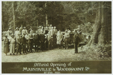
Photograph (Item) - Black and white photograph, Official Opening of MARYSVILLE to WOODSPOINT RD 5th Feb, 1923, 05-02-1924
... The Marysville-Woods Point Road was originally part of the Yarra Track, constructed in the early 1860s to provide access between Healesville and the Woods Point Goldfields. Despite the steep terrain and engineering difficulties, the Yarra Track soon became a busy route used by pack horses, horse-drawn drays, and wagons. ...An early black and white photograph which was taken after the ceremonial re-opening of the Marysville-Wood's Point Road in 1924. The date of 1923 on the photograph is incorrect.An early black and white photograph which was taken after the ceremonial re-opening of the Marysville-Wood's Point Road in 1924. The date of 1923 on the photograph is incorrect. The Marysville-Woods Point Road was originally part of the Yarra Track, constructed in the early 1860s to provide access between Healesville and the Woods Point Goldfields. Despite the steep terrain and engineering difficulties, the Yarra Track soon became a busy route used by pack horses, horse-drawn drays, and wagons. Today this sealed mountain road is a popular scenic drive between Marysville and Warburton.Official Opening of/ MARYSVILLE to WOODSPOINT RD/ 5th Feb, 1923marysville-wood's point road, marysville, wood's point goldfields, healesville, yarra track, warburton, the argus -
 Marysville & District Historical Society
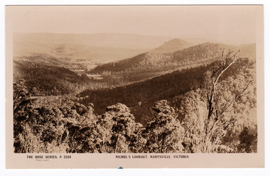
Postcard (item) - Black and white postcard, Rose Stereograph Company, Nichol's Lookout, Marysville, Victoria, 1913-1967
... The Marysville-Woods Point Road was originally part of the Yarra Track, constructed in the early 1860s to provide access between Healesville and the Woods Point Goldfields. Despite the steep terrain and engineering difficulties, the Yarra Track soon became a busy route used by pack horses, horse-drawn drays, and wagons. ...A postcard in a series produced by the Rose Stereograph Company in Victoria, Australia as a souvenir of Marysville.A black and white photograph of the view of the surrounding hills from Nichol's Lookout which is on the Marysville-Wood's Point road near Marysville in Victoria. The Marysville-Woods Point Road was originally part of the Yarra Track, constructed in the early 1860s to provide access between Healesville and the Woods Point Goldfields. Despite the steep terrain and engineering difficulties, the Yarra Track soon became a busy route used by pack horses, horse-drawn drays, and wagons. Today this sealed mountain road is a popular scenic drive between Marysville and Warburton.POST CARD The "Rose" Series/ De Luxe A Real Photograph/ Produced in Australia Published by the Rose Stereograph Co.,/ Armadale, Victoria. "The Falls"/ Marysville/ Monday Dear Mrs Wilson. Just a line to let you know/ I'm here by Dr's advice. He advised me/ to get extended leave. I'm suffering from/ blood pressure so have to go slow-no/ walking-Ugh-a bitter pill to swallow/ in these glorious surroundings. However/ I'm feeling much better and hope on my/ return (Saturday) to be able to resume duty/ I trust you and yours are well, Your loving/ friend A Butler. Quite/ an imposing/ hotel now/ stands at/ Keppel's/ Corner./ A.B.nicol's lookout, lookout, marysville, victoria, p. 2324, rose series postcard, postcard, souvenir, yarra track, mining, wood's point -
 Marysville & District Historical Society
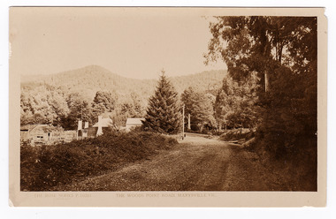
Postcard (item) - Black and white postcard, Rose Stereograph Company, The Wood's Point Road, Marysville, Vic, 1913-1967
... The Marysville-Woods Point Road was originally part of the Yarra Track, constructed in the early 1860s to provide access between Healesville and the Woods Point Goldfields. Despite the steep terrain and engineering difficulties, the Yarra Track soon became a busy route used by pack horses, horse-drawn drays, and wagons. ...A postcard in a series produced by the Rose Stereograph Company in Victoria, Australia as a souvenir of Marysville.A black and white photograph of the Wood's Point Road in Marysville , Victoria. This is now known as the Marysville-Wood's Point Road. The Marysville-Woods Point Road was originally part of the Yarra Track, constructed in the early 1860s to provide access between Healesville and the Woods Point Goldfields. Despite the steep terrain and engineering difficulties, the Yarra Track soon became a busy route used by pack horses, horse-drawn drays, and wagons. Today this sealed mountain road is a popular scenic drive between Marysville and Warburton.POST CARD REAL PHOTO THE "ROSE" SERIES DE LUXE PRODUCED IN AUSTRALIA Published by "The Rose Stereographer"/ Sydney and Melbourne.wood's point road, marysville-wood's point road, marysville, victoria, p. 10201, rose series postcard, postcard, souvenir, yarra track, mining, wood's point, warburton
