Showing 88 items matching "wagon track"
-
 Chelsea & District Historical Society Inc
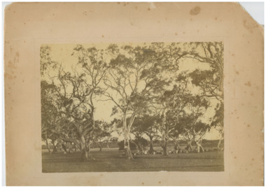
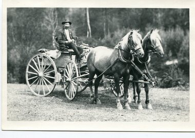
Photograph - Mr Hugh Brown and descendants, Mr Hugh Brown's Farm - "Pine Vale", c 1865
... ...wagon track...Hugh Brown Mordialloc pioneer Pine Vale farm orchard fruit trees cattle wagon track fence Black and white studio photo of Mr Hugh Brown's farm. ...Mr Hugh Brown farm, collecting logs for fence and preparing the ground to grow fruit trees. Mr Brown planted 8 acres of fruit trees. Hugh Brown (1830-1930), born in Ireland, arrived in Adelaide in 1855 and in the Mordialloc district in 1856. Mr Brown brought land in 1866 and built his farmhouse “Pine Vale” in 1870 near the site of the present Mordialloc Secondary College (then part of the property) and extended his property when the swampland was made open for selection in 1871. The property was a market garden and orchard. Hugh Brown married Zillah Baxter (1866) and they had six sons, five living to adulthood. The Brown family increased their land holding until they held a major part of the farmland between Mordialloc Creek to almost the Aspendale Railway Station. The property was a market garden and orchard. Mr Brown took an active interest in the public life of the community, a Justice of the Peace; Councillor of Dandenong Shire for over 30 years, was twice Shire President; and a founding member of the Mordialloc Mechanics Institute. Black and white studio photo of Mr Hugh Brown's farm. Gum trees and cleared land.hugh brown, mordialloc, pioneer, pine vale, farm, orchard, fruit trees, cattle, wagon track, fence -
 Eltham District Historical Society Inc
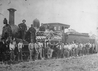
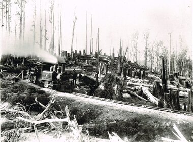
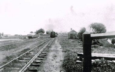
Negative - Photograph, Railway construction gang, Heidelberg-Eltham railway extension, c.1899-c.1901
... The first wagon contains track ballast and the sides have been lowered for the men to shovel it out for distribution on the track. ...The first wagon contains track ballast and the sides have been lowered for the men to shovel it out for distribution on the track. ...Group of men, a railway construction gang, some with shovels, pose beside an old R-Class 0-6-0 steam locomotive (built by Phoenix Foundry) during construction of the Heidelberg to Eltham line circa 1899-1901. The first wagon contains track ballast and the sides have been lowered for the men to shovel it out for distribution on the track. The tall man without hat beside the tender is "Mrs Batherway's Grandfather". Mr Harry Batherway lived in Bridge St, Eltham, between Tillings Timber and Joslyn's and is the original source of this photo about 1970 when photos were collected from the community for the Eltham "Pioneers & Painters" history publication.This photo forms part of a collection of photographs gathered by the Shire of Eltham for their centenary project book,"Pioneers and Painters: 100 years of the Shire of Eltham" by Alan Marshall (1971). The collection of over 500 images is held in partnership between Eltham District Historical Society and Yarra Plenty Regional Library (Eltham Library) and is now formally known as 'The Shire of Eltham Pioneers Photograph Collection'. It is significant in being the first community sourced collection representing the places and people of the Shire's first one hundred years.Digital image 4 x 5 inch B&W Neg B&W Print 18 x 25 cm B&W Print 16 x 21.5 cmsepp, shire of eltham pioneers photograph collection, eltham, railway construction, railway gangers, railways, steam locomotive, workers, old r-class 0-6-0 steam locomotive -
 Bendigo Historical Society Inc.
Slide - DIGGERS & MINING. DIGGERS AND MINERS, c1800s
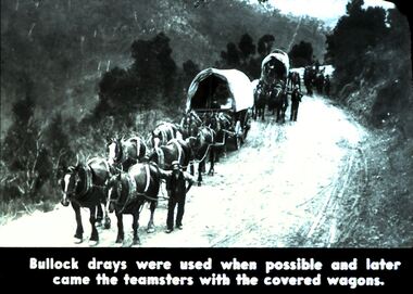
... Men with the wagons. On a track carved into a mountain. Markings: 13 995 WAL. ...Men with the wagons. On a track carved into a mountain. Markings: 13 995 WAL. ...Diggers & Mining. Diggers and miners. Walhalla - Gold Town. Bullock drays were used when possible and later came the teamsters with the covered wagons. Picture shows 3 covered wagons pulled by teams of eight horses. Men with the wagons. On a track carved into a mountain. Markings: 13 995 WAL. Used as a teaching aid.hanimounteducation, tertiary, goldfields -
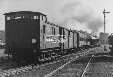
 Eltham District Historical Society Inc
Photograph, George Coop, Steam locomotive J-502 hauling a specialist plant track repair and goods recovery train departing Echuca, Aug. 1963
... A special plant track repair and goods recovery train proceeding to a cattle train derailment on the Balranald (NSW) line from which sheep had also escaped. The train composition was made up of J-Class steam locomtive J-502, a water gin carrying extra water for the train given doubtful supplies en-route, a wagon to reload the surviving sheep, a wagon containing track tools and equipment, a carriage for the work crew, a bogie wagon containing all the specialist tools for re-railing the train, followed lastly by the Guard's van. ...Eltham District Historical Society Inc 728 Main Rd Eltham melbourne A special plant track repair and goods recovery train proceeding to a cattle train derailment on the Balranald (NSW) line from which sheep had also escaped. The train composition was made up of J-Class steam locomtive J-502, a water gin carrying extra water for the train given doubtful supplies en-route, a wagon to reload the surviving sheep, a wagon containing track tools and equipment, a carriage for the work crew, a bogie wagon containing all the specialist tools for re-railing the train, followed lastly by the Guard's van. ...A special plant track repair and goods recovery train proceeding to a cattle train derailment on the Balranald (NSW) line from which sheep had also escaped. The train composition was made up of J-Class steam locomtive J-502, a water gin carrying extra water for the train given doubtful supplies en-route, a wagon to reload the surviving sheep, a wagon containing track tools and equipment, a carriage for the work crew, a bogie wagon containing all the specialist tools for re-railing the train, followed lastly by the Guard's van. The specialist wagons and their equipment were based at the Bendigo Depot (see painted markings on van side) in a state of readiness for immediate use as the need arose The train is viewed approaching the Iron Bridge grade out of the Echuca rail yard. The Gatekeepers hut is visible on the right. The gatekeeper would be notified of the approaching train at which time he would open the gate to allow the train to pass through the Packenham Street level crossing.Digital TIFF file Scan of black and white print Enlargement prints on textured paper (15.5 x 20.5 cm)george coop collection, echuca, j-502, j-class steam locomotive (vulcan foundry) -
 Bendigo Military Museum
Photograph - Johnson Ground Elevation Meter (JGEM) Survey Vehicle - Army Survey Regiment, Fortuna, Bendigo, c1960s
... A limited number of Ground Elevation Meter (GEM) station wagon type vehicles were manufactured by General Motors Corporation (GMC) in the USA for the United States Geological Survey, Canada’s mapping agencies, RA Svy and National Mapping (Natmap). The GEM was a four-wheel drive, four-wheel steer vehicle. Four-wheel steering was necessary to avoid systematic errors caused by non-tracking...A limited number of Ground Elevation Meter (GEM) station wagon type vehicles were manufactured by General Motors Corporation (GMC) in the USA for the United States Geological Survey, Canada’s mapping agencies, RA Svy and National Mapping (Natmap). The GEM was a four-wheel drive, four-wheel steer vehicle. Four-wheel steering was necessary to avoid systematic errors caused by non-tracking ...This is a set of 16 photograph of the Royal Australian Survey Corps’ Johnson Ground Elevation Meter (JGEM) Survey Vehicle taken at the Army Survey Regiment, Fortuna, Bendigo. The JGEM vehicle was extensively used by RA Svy within Australia from the late 1960s. A limited number of Ground Elevation Meter (GEM) station wagon type vehicles were manufactured by General Motors Corporation (GMC) in the USA for the United States Geological Survey, Canada’s mapping agencies, RA Svy and National Mapping (Natmap). The GEM was a four-wheel drive, four-wheel steer vehicle. Four-wheel steering was necessary to avoid systematic errors caused by non-tracking of front and rear wheels on conventionally steered vehicles. The manufacturer substituted the rear axle with a front axle and connected them to form the four-wheel steering mechanism. The two Australian GEM vehicles, referred to as Johnson GEMs (JGEMs) were converted into right-hand drive. After delivery in 1964, acceptance Natmap and RA Svy testing and operator training was undertaken at the Army's School of Military Survey located at Balcombe, Victoria. A small fifth wheel was mounted on a cantilever arm suspension midway between the front and rear wheels on the right side of the vehicle. It was lowered to and raised from its operating position by use of a constant pressure air cylinder. A telescopic bar, suspended between the front and rear axles, provided the reference datum for the angle measurement. The wheel provided the velocity or distance signal through a pulse generator system. A sensitive pendulum mounted on this bar provided the angle measurement for each minute distance traversed. The JGEM contained electromechanical instruments used to determine relative elevations, by trigonometric principles, along a traversed path. These relative elevations were obtained through apparatus which measures the instantaneous angle of inclination of the road and the instantaneous velocity of the meter along such a path. Road routes over which the JGEM operated were planned so that each started and ended as near as practicable to an existing point of known elevation (formally referred to as a level traverse bench mark). The difference in height from the bench mark and the road surface alongside the JGEM’s fifth wheel was measured with a level and staff. Along each route, mapping control photo reference points where new elevation values were required were identified on aerial photographs. Under favourable conditions it was possible to survey as much as 160km in an ordinary working day. The first of RA Svy’s JGEM operations was undertaken in 1:250,000 scale map areas of Queensland. CPL John Hook was the JGEM’s main operator in the early 1970s undertaking operations covering 1:250,000 scale map blocks over northern Victoria and central NSW, each requiring 36 points (9 runs of photography and 4 points across. SPR Lyn Thompson and SPR Bob McDonagh teamed with CPL Hook on some of these JGEM operations. When RA Svy was integrated into the Royal Australian Engineers in 1996, the JGEM vehicle with the Survey Corps collection was donated to its museum. It is believed to be the last of the original manufactured fleet in existence. The JGEM has undergone extensive refurbishment to achieve roadworthiness and is currently housed at The Australian Army Museum of Military Engineering, Hoslworthy Barracks, NSW. It can be viewed by making an appointment with the museum’s curator.This is a set of 16 photograph of the Royal Australian Survey Corps’ Johnson Ground Elevation Meter (JGEM) Survey Vehicle taken at the Army Survey Regiment, Fortuna, Bendigo. The photographs were on 35mm slide film and were scanned at 96 dpi. They are part of the Army Survey Regiment’s Collection. .1) - Photo, colour, c1960s, Johnson Ground Elevation Meter (JGEM) Survey Vehicle .2) - Photo, colour, c1960s, JGEM instrumentation, on-board computer. .3) - Photo, colour, c1960s, JGEM instrumentation. .4) - Photo, colour, c1960s, JGEM instrumentation, on-board computer. .5) - Photo, colour, c1960s, JGEM tyre pressure controller .6) - Photo, colour, c1960s, JGEM rear doors, SGT Geoff Briggs. .7) - Photo, colour, c1960s, JGEM 5th wheel distance/angle measurement device in lowered position, SGT Geoff Briggs. .8) - Photo, colour, c1960s, JGEM 5th wheel distance/angle measurement device in lowered position. .9) & .10) - Photo, colour, c1960s, JGEM tyre pressure system, SGT Geoff Briggs. .11) - Photo, colour, c1960s, JGEM tyre pressure system. SGT Geoff Briggs. .12) - Photo, colour, c1960s, JGEM levelling scope, levelling staff, unidentified technicians. .13) & .14) - Photo, colour, c1960s, JGEM levelling scope, unidentified technician. .15) & .16) - Photo, colour, c1960s, probably survey operation adjusted height plotted on block base sheet. .1P to .16P - Some of the equipment is annotated on the frame of the 35mm slides.royal australian survey corps, rasvy, army survey regiment, army svy regt, fortuna, asr, surveying -
 Eltham District Historical Society Inc
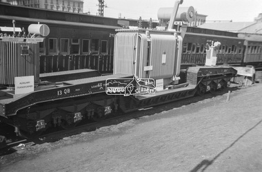
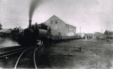
Photograph, George Coop, Power transformer on a QB boiler/flat wagon on display at Spencer Street Railway Station during the 1954 Victorian Railways Centenary Exhibition, Sep. 1954
... track, electrical and other railway equipment held at Spencer Street Railway Station. George Coop Collection Display Spencer Street Railway Station V.R. Cavalcade Victorian Railways Centenary 1854-1954 Exhibition Power transformer QB Boiler/Flat Wagon QB-13 Digital TIFF file Scan of Kopdak 620 black and white negative transparency Power transformer on a QB boiler/flat wagon on display at Spencer Street Railway Station during the 1954 Victorian Railways Centenary Exhibition Photograph Photograph George Coop ..."V.R. Cavalcade" Centenary 1854-1954 Exhibition (11-25 Sep 1954) presented a model railway occupying about 1,400 square feet in the Lower Town Hall featuring a number of model railway working scale models. The exhibition also included a display of rolling stock, track, electrical and other railway equipment held at Spencer Street Railway Station.Digital TIFF file Scan of Kopdak 620 black and white negative transparencygeorge coop collection, display, spencer street railway station, v.r. cavalcade, victorian railways centenary 1854-1954 exhibition, power transformer, qb boiler/flat wagon, qb-13 -
 Glen Eira Historical Society
Document - GARDENVALE
... Lempriere’s Paddock, rail tracks on the main roads for the use of market gardeners’ wagons. Sale of land for O’Neill College Estate and construction of a subway through the railway embankment to Gardenvale Shopping centre, including efforts by local people and the council for work to be completed and costs. ...Lempriere’s Paddock, rail tracks on the main roads for the use of market gardeners’ wagons. Sale of land for O’Neill College Estate and construction of a subway through the railway embankment to Gardenvale Shopping centre, including efforts by local people and the council for work to be completed and costs. ...This file contains two items about Gardenvale, which was previously all part of Caulfield: 1/Photocopied eight page document by M. Stewart, 1961, entitled ‘The Gardenvale Story’. It describes Gardenvale Railway and surrounding roads and land. Lempriere’s Paddock, rail tracks on the main roads for the use of market gardeners’ wagons. Sale of land for O’Neill College Estate and construction of a subway through the railway embankment to Gardenvale Shopping centre, including efforts by local people and the council for work to be completed and costs. Footnote is circa 1977. 2/Map of Glen Eira printed from Council website 20/06/2014 showing Glen Eira’s share of Gardenvale.gardenvale, bent thomas, brighton, caulfield, elsternwick, railway stations, lempriere family, ‘bentville’, lempriere’s paddock, market gardens, nepean highway, nepean road, north road, kooyong road, polo, sheridan family, bluestone houses, bethlehem hospital, land subdivision, begonia street, gardenia road, gardenia street, magnolia street, lantana street, martin street, shops, ‘ben burb’, house names, padua hospital, brighton, o’neill miss, o’neill college, o’neill richard, o’neill estate, elster avenue, o’neill college estate, railway crescent, denver crescent, brentani avenue, college street, rosstown railway, brighton cemetery, ross mr, hawthorn road, ormond, gardenvale progress association, elster creek, parliamentary representatives, landscapes, gardenvale road, railway lines, subways, traders association, drainage, floods -
Glen Eira Historical Society
Photograph - Elsternwick Fire Station, Selwyn Street
... track. Elsternwick Fire brigades Fire fighters Elsternwick Fire Brigade Horse drawn vehicles Carts and wagons Photograph Elsternwick Fire Station, Selwyn Street ...A photocopied black and white photograph (96mm x 127mm) of the 1891 Elsternwick Fire Brigade on their way to a fire with a crew of three fire fighters in a one-horse cart racing up a track.elsternwick, fire brigades, fire fighters, elsternwick fire brigade, horse drawn vehicles, carts and wagons -
 Halls Gap & Grampians Historical Society
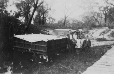
Photograph - B/W, C 1932
... A mans hat sits on the tarpaulin near the man's elbow.The wagon appears to be standing in water and there is a wooden slat surfaced bridge ortrestle to the right. A track...A mans hat sits on the tarpaulin near the man's elbow.The wagon appears to be standing in water and there is a wooden slat surfaced bridge ortrestle to the right. A track ...A family on holiday in the Grampians. The deep wagon is an early form of caravan, which folded down and was ready to erect when a site was found. The man is Jack Diamond from Donald.The photo shows a family (a man, a woman, a girl and a boy) standing beside an old car pulling a deep, wooden wagon covered by a tarpaulin. A mans hat sits on the tarpaulin near the man's elbow.The wagon appears to be standing in water and there is a wooden slat surfaced bridge ortrestle to the right. A track with two signposts is in front of the car and there is thin bush in the background.recreation, camping, transport, cars -
Phillip Island and District Historical Society Inc.
Photograph, circa 1900
... Foreground track leading down to two jetties and shed of San Remo Harbour. Near shed a covered wagon. ...Phillip Island and District Historical Society Inc. phillip-island-and-the-bass-coast Foreground track leading down to two jetties and shed of San Remo Harbour. Near shed a covered wagon. ...Foreground track leading down to two jetties and shed of San Remo Harbour. Near shed a covered wagon. Coal boat at end of jetty. Large shrubbery on left of picture. Phillip Island foreshore across Westernport in background.Track leading to passenger and coal jetties, Phillip IslandPhillip Island from San Remo Harbourlocal history, photography, photographs, slides, film, san remo harbour, jetties, black & white photograph, miss elms san remo -
 Eltham District Historical Society Inc
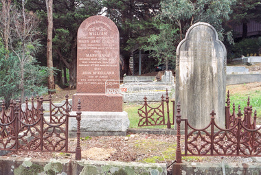
Negative - Photograph, Harry Gilham, Graves of William J and Mary Jane (nee Vance) Crozier and their sons Thomas Vance and John McClelland Crozier, Eltham Cemetery, Victoria, 1 Aug 2007
... wagon. The Croziers were Episcopalians and soon after arriving in Eltham the Wesleyans of Little Eltham were holding services in the Crozier's home, among other locations. It was not until January 1856 that the Wesleyan church first acquired land in Henry Street for a chapel, which later became the home of the Eltham Hall. The Crozier home, known as ‘Belmont’ was weatherboard with a rammed earth floor. It was situated on twenty-four acres along the track...wagon. The Croziers were Episcopalians and soon after arriving in Eltham the Wesleyans of Little Eltham were holding services in the Crozier's home, among other locations. It was not until January 1856 that the Wesleyan church first acquired land in Henry Street for a chapel, which later became the home of the Eltham Hall. The Crozier home, known as ‘Belmont’ was weatherboard with a rammed earth floor. It was situated on twenty-four acres along the track ...William Crozier was born 1823 in County Armagh, Ireland. Mary Jane Vance was born 1829 in Desecrete, County Tyrone, Ireland. They were married in 1848. On New Year's Eve, 1849, together with their baby daughter Sarah, William and Mary embarked from Plymouth aboard the Eliza Caroline, as assisted immigrants, for Port Phillip, arriving 31 March 1850 from where they journeyed out to Eltham on a bullock wagon. The Croziers were Episcopalians and soon after arriving in Eltham the Wesleyans of Little Eltham were holding services in the Crozier's home, among other locations. It was not until January 1856 that the Wesleyan church first acquired land in Henry Street for a chapel, which later became the home of the Eltham Hall. The Crozier home, known as ‘Belmont’ was weatherboard with a rammed earth floor. It was situated on twenty-four acres along the track at its rise, about half-a-mile east of Maria Street (Main Road) bounded by Mt Pleasant Road on the south and Pitt Street northwards. William Crozier used the land for cultivation and grazing. The track the Eltham Wesleyans took, by foot or horse, was along the Mt Pleasant Road, and like most roads of the time, a dusty trail in summer and a hoof and cart rutted quagmire in winter. William and Mary Crozier had seven children: Sarah, (1848 Ireland), John McClelland (1851 Eltham), Eliza (1855 Eltham), William (1857 Eltham), Jane(1859 Yarraville), Charlotte Amelia (1861 Yarraville), and Thomas Vance (1864 Eltham). The Crozier farm prospered and in 1870, William applied for, and was granted a leasehold on an additional sixty-three-acre selection, half-a-mile east of his twenty-four-acre Mt Pleasant Road property. Upon this property he built a two-roomed dwelling of slats and bark and a storeroom of log and bark, ten feet square. In 1880 he applied for a Crown grant of the property. Tragedy struck the family in 1882 when the youngest, Thomas Vance at age 17 accompanied by John Anderson, went into "Hall's Dam" to bathe, neither of them being able to swim. On wading out together, Crozier suddenly slipped into a part about 10ft. deep, and sank, after rising only once. Anderson pluckily tried to save him, nearly losing his own life in the attempt, saving himself when sinking for the last time by seizing hold of a projecting root. The body was not recovered until two hours after, when Mr. Thomas Bell, a farmer in the locality, who was attracted to the spot, on hearing of the occurrence, although unable to swim, plunged in with a rope around his waist, and succeeded with some difficulty in bringing it to the surface. Their eldest son, John also died prematurely at age 42 when he was killed by a falling tree branch whilst engaged in ring-barking trees at Eltham. A still cold wind was blowing and John, and others who were working with him, sheltered themselves at lunch time by sitting on the side of a large tree. When thus seated, the wind detached a limb of the tree which sheltered them, and though they heard the cracking, they had not time to get clear before the limb fell. It struck John on the head, and felled him to the ground, He appeared to be suffering severe pain, and two of his companions conveyed him to the Melbourne Hospital, where during the night he was operated upon for a fracture of the skull. Despite the operation being successful, John ultimately succumbed to his injuries the following afternoon. In good times William was known for his wealth of reminiscences of the early days of the district however his health failed him for several years until his death in March 1909. He was a man of very industrious habits, of a retiring disposition and much esteemed by those who knew him best. Mary died in January 1915 after a long illness. They are buried together along with their sons John and Thomas in the Eltham Cemetery. In Loving Remembrance William Beloved husband of Mary Jane Crozier Who departed this life March 31st 1909, aged 85 years Also Mary Jane Beloved wife of the above Who departed this life January 3rd 1915, aged 86 years Also John McCelland Son of the above Who departed this life May 20th 1894, aged 42 years also Sacred Memory of Thomas Vance Dearly beloved son of William J. Crozier Who departed this life at Eltham, February 3rd 1882 Aged 17 yearseltham cemetery, gravestones, memorials, film - kodak gold gc 400-9, john mccelland crozier, mary jane crozier (nee vance), scan - 35mm negative, thomas vance crozier, william crozier, william j crozier -
 Eltham District Historical Society Inc
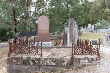
Photograph, Peter Pidgeon, Graves of William J and Mary Jane (nee Vance) Crozier and their sons Thomas Vance and John McClelland Crozier, Eltham Cemetery, Victoria, 5 April 2021
... wagon. The Croziers were Episcopalians and soon after arriving in Eltham the Wesleyans of Little Eltham were holding services in the Crozier's home, among other locations. It was not until January 1856 that the Wesleyan church first acquired land in Henry Street for a chapel, which later became the home of the Eltham Hall. The Crozier home, known as ‘Belmont’ was weatherboard with a rammed earth floor. It was situated on twenty-four acres along the track...wagon. The Croziers were Episcopalians and soon after arriving in Eltham the Wesleyans of Little Eltham were holding services in the Crozier's home, among other locations. It was not until January 1856 that the Wesleyan church first acquired land in Henry Street for a chapel, which later became the home of the Eltham Hall. The Crozier home, known as ‘Belmont’ was weatherboard with a rammed earth floor. It was situated on twenty-four acres along the track ...William Crozier was born 1823 in County Armagh, Ireland. Mary Jane Vance was born 1829 in Desecrete, County Tyrone, Ireland. They were married in 1848. On New Year's Eve, 1849, together with their baby daughter Sarah, William and Mary embarked from Plymouth aboard the Eliza Caroline, as assisted immigrants, for Port Phillip, arriving 31 March 1850 from where they journeyed out to Eltham on a bullock wagon. The Croziers were Episcopalians and soon after arriving in Eltham the Wesleyans of Little Eltham were holding services in the Crozier's home, among other locations. It was not until January 1856 that the Wesleyan church first acquired land in Henry Street for a chapel, which later became the home of the Eltham Hall. The Crozier home, known as ‘Belmont’ was weatherboard with a rammed earth floor. It was situated on twenty-four acres along the track at its rise, about half-a-mile east of Maria Street (Main Road) bounded by Mt Pleasant Road on the south and Pitt Street northwards. William Crozier used the land for cultivation and grazing. The track the Eltham Wesleyans took, by foot or horse, was along the Mt Pleasant Road, and like most roads of the time, a dusty trail in summer and a hoof and cart rutted quagmire in winter. William and Mary Crozier had seven children: Sarah, (1848 Ireland), John McClelland (1851 Eltham), Eliza (1855 Eltham), William (1857 Eltham), Jane(1859 Yarraville), Charlotte Amelia (1861 Yarraville), and Thomas Vance (1864 Eltham). The Crozier farm prospered and in 1870, William applied for, and was granted a leasehold on an additional sixty-three-acre selection, half-a-mile east of his twenty-four-acre Mt Pleasant Road property. Upon this property he built a two-roomed dwelling of slats and bark and a storeroom of log and bark, ten feet square. In 1880 he applied for a Crown grant of the property. Tragedy struck the family in 1882 when the youngest, Thomas Vance at age 17 accompanied by John Anderson, went into "Hall's Dam" to bathe, neither of them being able to swim. On wading out together, Crozier suddenly slipped into a part about 10ft. deep, and sank, after rising only once. Anderson pluckily tried to save him, nearly losing his own life in the attempt, saving himself when sinking for the last time by seizing hold of a projecting root. The body was not recovered until two hours after, when Mr. Thomas Bell, a farmer in the locality, who was attracted to the spot, on hearing of the occurrence, although unable to swim, plunged in with a rope around his waist, and succeeded with some difficulty in bringing it to the surface. Their eldest son, John also died prematurely at age 42 when he was killed by a falling tree branch whilst engaged in ring-barking trees at Eltham. A still cold wind was blowing and John, and others who were working with him, sheltered themselves at lunch time by sitting on the side of a large tree. When thus seated, the wind detached a limb of the tree which sheltered them, and though they heard the cracking, they had not time to get clear before the limb fell. It struck John on the head, and felled him to the ground, He appeared to be suffering severe pain, and two of his companions conveyed him to the Melbourne Hospital, where during the night he was operated upon for a fracture of the skull. Despite the operation being successful, John ultimately succumbed to his injuries the following afternoon. In good times William was known for his wealth of reminiscences of the early days of the district however his health failed him for several years until his death in March 1909. He was a man of very industrious habits, of a retiring disposition and much esteemed by those who knew him best. Mary died in January 1915 after a long illness. They are buried together along with their sons John and Thomas in the Eltham Cemetery. In Loving Remembrance William Beloved husband of Mary Jane Crozier Who departed this life March 31st 1909, aged 85 years Also Mary Jane Beloved wife of the above Who departed this life January 3rd 1915, aged 86 years Also John McCelland Son of the above Who departed this life May 20th 1894, aged 42 years also Sacred Memory of Thomas Vance Dearly beloved son of William J. Crozier Who departed this life at Eltham, February 3rd 1882 Aged 17 yearsBorn Digitaleltham cemetery, gravestones, john mccelland crozier, mary jane crozier (nee vance), thomas vance crozier, william j crozier -
 Otway Districts Historical Society
Photograph, Les Ogden, Crowes track being dismantled at ashpit, 1961, 1961
... Crowes track being dismantled at the ashpit ready for loading into NQR wagons. ...The track to Crowes was pulled up in 1961. colac; beech forest; crowes: railway; Crowes track being dismantled at the ashpit ready for loading into NQR wagons. Crowes track being dismantled at ashpit, 1961 Photograph Les Ogden ...On the Colac-Beech Forest-Crowes railway line the section from Ferguson to Crowes was closed in December 1954, but reopened as far as Weeaproinah in January 1955. The section to Crowes, left to its own devices, was rapidly covered with vegetation which had to be cleared when rail recovery trains later ran. The track to Crowes was pulled up in 1961. Crowes track being dismantled at the ashpit ready for loading into NQR wagons. colac; beech forest; crowes: railway; -
 Otway Districts Historical Society
Photograph, Woosnan, Frank, Track gang at Beech Forest, c.1940, c.1940
... Track gang on an NK wagon at Beech Forest, c.1940. Snow covers the ground. ...The track was maintained by seven three-man gangs based at Colac, Barongarook, Gellibrand, Banool, Beech Forest (where the second Beech Forest crew was based at Wyelangta), and Lavers Hill. colac; beech forest; crowes; railway; track gangs; Track gang on an NK wagon at Beech Forest, c.1940. Snow covers the ground. ...At its peak the Colac-Beech Forest-Crowes railway employed more than 21 staff tending the lines that the trains ran over. Gangers (the men in charge of the track gangs) tended to be promoted into the Otways but many of their subordinate repairers were local recruits. A few of the men who worked on the original construction gangs of 1900-02 remained and obtained positions in the track gangs along the line, but these eased out over time. The track was maintained by seven three-man gangs based at Colac, Barongarook, Gellibrand, Banool, Beech Forest (where the second Beech Forest crew was based at Wyelangta), and Lavers Hill.Track gang on an NK wagon at Beech Forest, c.1940. Snow covers the ground. B/W.colac; beech forest; crowes; railway; track gangs; -
 Otway Districts Historical Society
Photograph, R.L. Forster, G41, Beech Forest, 1950, 1950
... Track. The plant was later shifted to Pul's property and, in 1951, finally moved to a new mill in the Beech Forest railway yard. Potato output also rose, around 280 hectares and was shipped exclusively by rail until 1955. The railway was very busy, in fact so busy that potato farmers and especially saw millers started agitating for road transport. beech forest; railways; loco g41; G41 locomotive, four NQR loaded wagons, and a louvred van near the Goods Shed. ...From 1945 a sawmill, the Calco Mill, was formed to cart sawn timber initially from the Zappelli's property on Denherts Track. The plant was later shifted to Pul's property and, in 1951, finally moved to a new mill in the Beech Forest railway yard. Potato output also rose, around 280 hectares and was shipped exclusively by rail until 1955. The railway was very busy, in fact so busy that potato farmers and especially saw millers started agitating for road transport.G41 locomotive, four NQR loaded wagons, and a louvred van near the Goods Shed. Next line, three loaded and three empty NQR wagons. In the foreground near the station building, a louvred van. A water tank and timber mill in the background. B/Wbeech forest; railways; loco g41; -
 Otway Districts Historical Society
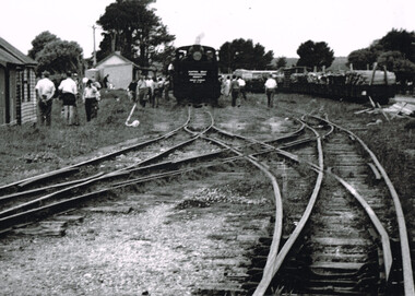
Photograph, Ray Jude, Beech Forest showing the delta crossover, 1959, 21 November 1959
... wagons loaded with wood and louvred van rest in the background. Note the delta or 'scissors' crossover between lines in the centre of the picture. beech forest; railways; B/W. Beech Forest Railway Station with a G41 locomotive, showing the sign "Puffing Billy Preservation Society, Beech Forest, 25-11-59" on track number one, mixed goods trucks on track number three, passengers throughout, and the delta or scissors crossover line, at 21 November 1959. ...On 21 November 1959 yet another special train was run, this time on a G41 engine showing the sign "Puffing Billy Preservation Society, Beech Forest, 25-11-59", with eight NBH excursion carriages and a guard's van. The train stopped at Beech Forest where people removed themselves and wandered around the station. Mixed goods wagons loaded with wood and louvred van rest in the background. Note the delta or 'scissors' crossover between lines in the centre of the picture.B/W. Beech Forest Railway Station with a G41 locomotive, showing the sign "Puffing Billy Preservation Society, Beech Forest, 25-11-59" on track number one, mixed goods trucks on track number three, passengers throughout, and the delta or scissors crossover line, at 21 November 1959.beech forest; railways; -
 Otway Districts Historical Society
Photograph, Derailment at Beech Forest, c.1950, c.1950
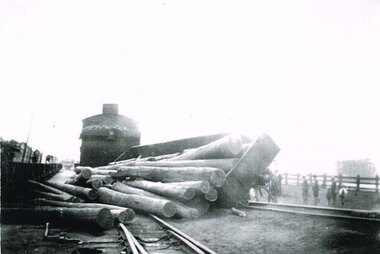
... In c.1950 in Beech Forest an NQR wagon load of wood is derailed while changing tracks behind an NA-class locomotive. ...In c.1950 in Beech Forest an NQR wagon load of wood is derailed while changing tracks behind an NA-class locomotive. ...B/W. In c.1950 in Beech Forest an NQR wagon load of wood is derailed while changing tracks behind an NA-class locomotive. People are watching. On the left are NQR wagons.beech forest; railways; -
 Otway Districts Historical Society
Photograph, Beech Forest Railway Station, 1910, 1910
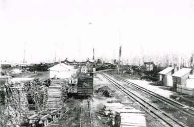
... Note the Goods Shed, three tracks with No.3 Road having a NU louvre van and loaded NQR wagons, timber stacks to the left, and Devitt's Tramway with unloaded trolleys at the lower left. ...Note the Goods Shed, three tracks with No.3 Road having a NU louvre van and loaded NQR wagons, timber stacks to the left, and Devitt's Tramway with unloaded trolleys at the lower left. ...By 1910 revenue from the Beech Forest railway was $15,500, working expenditure $12,000, with a net loss (including interest charges) of about $4,000. This and the following year were the lowest net losses ever experienced. Passenger journeys rose steadily, outwards goods traffic rose to a record 12,959 tons (in 1911), and inwards goods traffic was a record 3,359 tons.. The railway station possessed a goods shed, stock race and yards, engine shed, coal stage, crew cabins, a refreshment room, and a four-roomed station building, with the station staff to match. Beech Forest was the principal despatch centre at this stage for split timber. Bill Devitt laid a timber tramway to the Beech Forest railway station to cart the palings for on-shipment..B/W. 177mm x 271mm. A general view from the eastern end of Beech Forest station in 1910. Note the Goods Shed, three tracks with No.3 Road having a NU louvre van and loaded NQR wagons, timber stacks to the left, and Devitt's Tramway with unloaded trolleys at the lower left. To the right, crew cabins with shops and houses in the background.beech forest; railways; timber; tramway; -
 Otway Districts Historical Society
Photograph, Victorian Railways, Between Devitt Bros. Siding & Ditchley, 1901, 1901
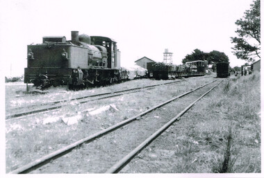
... track, as well as others forming the earthworks and building culverts and bridges. The result of this labour saw the railway advance from Colac until it climbed a spur hugging the side of a forty degree slope emerging on top of the ridge at Beech Forest. This photograph was taken 28 miles (45 kilometres) from Colac between Devitt Bros. Siding and Ditchley, just out of Beech Forest. Two 2-6-2 Tank engines of the narrow-gauge A class built by Victorian Railway's Newport workshop, were commonly dubbed 'Coffee Pots'. As well as pulling a load of NQR wagons...track, as well as others forming the earthworks and building culverts and bridges. The result of this labour saw the railway advance from Colac until it climbed a spur hugging the side of a forty degree slope emerging on top of the ridge at Beech Forest. This photograph was taken 28 miles (45 kilometres) from Colac between Devitt Bros. Siding and Ditchley, just out of Beech Forest. Two 2-6-2 Tank engines of the narrow-gauge A class built by Victorian Railway's Newport workshop, were commonly dubbed 'Coffee Pots'. As well as pulling a load of NQR wagons ...Construction of the Colac-Beech Forest railway line began in 1900 with about 100 men engaged in laying and ballasting the track, as well as others forming the earthworks and building culverts and bridges. The result of this labour saw the railway advance from Colac until it climbed a spur hugging the side of a forty degree slope emerging on top of the ridge at Beech Forest. This photograph was taken 28 miles (45 kilometres) from Colac between Devitt Bros. Siding and Ditchley, just out of Beech Forest. Two 2-6-2 Tank engines of the narrow-gauge A class built by Victorian Railway's Newport workshop, were commonly dubbed 'Coffee Pots'. As well as pulling a load of NQR wagons a NBB saloon car ended the train. The devastation to the standing timber was deliberate: the Engineer-in-Chief of VR ruled that all trees within a certain distance of the railway line were to be cut down. This certainly saved the line from destruction several times in the future.B/W. An NA class locomotive, NQR wagons and an NBB saloon car, all with workmen, going around a bend between Devitt Brother's Siding and Ditchley on the Beech Forest line in 1901.beech forest; ditchley; devitt bros siding, railways; -
 Otway Districts Historical Society
Photograph, Les Ogden, Out of Crowes, 1961, 1961
... Beginning at Crowes, groups of gangers started removing the tracks, loading them into NQR open wagons pushed by locomotive G42....Beginning at Crowes, groups of gangers started removing the tracks, loading them into NQR open wagons pushed by locomotive G42. crowes; beech forest; weeaproinah; railways; B/W. ...On 8 March 1962, after the line from Crowes to Weeaproinah was shut down. Beginning at Crowes, groups of gangers started removing the tracks, loading them into NQR open wagons pushed by locomotive G42.B/W. Four empty NQR open wagons with a group of gangers tearing up the lines.crowes; beech forest; weeaproinah; railways; -
 Otway Districts Historical Society
Photograph, Locomotive 8A and its mixed train at Colac Railway Station, c.1920, c.1920
... In 1922 a footbridge was erected over the broad gauge lines, and a passenger shelter and small goods shed were built on the departure track. colac; railway; narrow gauge; na locomotive; B/W. At Colac Railway Station, an locomotive 8A with five NQR wagons, an NM livestock wagon and a NBDBD combined passenger and brake van destined for Beech Forest, with either the driver or the fireman peering out of the engine, three youths standing at the front of the engine, and a group of people, including a woman, standing near the livestock wagon. ...Station facilities for the travelling public on the narrow gauge line at Colac Railway Station were non-existent for many years. Tickets were purchased from the broad gauge booking office and the travellers then had to walk with their luggage over the rough, potentially ankle-twisting, stone approaches, through the goods yard and wait in the open amongst the mud holes alongside the narrow gauge departure track. In 1922 a footbridge was erected over the broad gauge lines, and a passenger shelter and small goods shed were built on the departure track.B/W. At Colac Railway Station, an locomotive 8A with five NQR wagons, an NM livestock wagon and a NBDBD combined passenger and brake van destined for Beech Forest, with either the driver or the fireman peering out of the engine, three youths standing at the front of the engine, and a group of people, including a woman, standing near the livestock wagon. A multi-storied shed and two houses are in the background. 179mm x 280mm picture.colac; railway; narrow gauge; na locomotive; -
 Otway Districts Historical Society
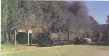
Photograph, R. Preston, Banool: Locomotive G42 and goods, c.1960, c.1960
... track, and therefore Banool became a staff and ticket station with a crossing loop and home signals. However, this only lasted for two years and was abolished as an economy measure in 1916. Loading figures show that in most years the outwards tonnage at Banool was less than 150 tonnes. The station was reduced to a passenger shelter and goods loop only by 1929, and by the time of closure in 1962 most trains were steaming through. banool; moorbanool; railways; locomotive g42; Colour. Locomotive G42 and its NQR goods wagons ...This original station on the Colac-Beech Forest line was first known as "Moorbanool" after the local parish, and then shortened to "Banool" on 1 November 1904. At first facilities consisted of a passenger shelter, a loop siding for 11 trucks, plus a residence for the ganger of the track gang based there. By 1912 with the extension of the line to Crowes increased train services on the line required a crossing station in this section of the track, and therefore Banool became a staff and ticket station with a crossing loop and home signals. However, this only lasted for two years and was abolished as an economy measure in 1916. Loading figures show that in most years the outwards tonnage at Banool was less than 150 tonnes. The station was reduced to a passenger shelter and goods loop only by 1929, and by the time of closure in 1962 most trains were steaming through.Colour. Locomotive G42 and its NQR goods wagons, loaded and unloaded, steaming past Banool station passenger shelter. 143mm x 274mm print.banool; moorbanool; railways; locomotive g42; -
 Otway Districts Historical Society
Photograph - Black and white photograph, Irene Zappelli Collection, empty, c. 1900
... Tracks 1 to 4 at Beech Forest, an NA-class locomotive and goods on No.1, an NQR wagon on No.4, and a station building in the right, in the early 1900s. 167mm x 280mm print....Otway Districts Historical Society Cliff Young Drive Beech Forest great-ocean-road beech forest train wagon railway tracks train station B/W. Tracks 1 to 4 at Beech Forest, an NA-class locomotive and goods on No.1, an NQR wagon on No.4, and a station building in the right, in the early 1900s. 167mm x 280mm print. empty Photograph Black and white photograph Irene Zappelli Collection ...B/W. Tracks 1 to 4 at Beech Forest, an NA-class locomotive and goods on No.1, an NQR wagon on No.4, and a station building in the right, in the early 1900s. 167mm x 280mm print.beech forest, train, wagon, railway, tracks, train station -
 Glenelg Shire Council Cultural Collection
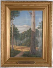
Painting, A Bush Track, n.d
... On the track heading towards the viewer is a covered wagon drawn by a white horse. ...On the track heading towards the viewer is a covered wagon drawn by a white horse. ...CEMA Art Collection Previously located in History HouseThe painting illustrates a bush scene with a large gum tree in the foreground. To the left of the tree is a sunny track with long shadows formed by surrounding trees. On the track heading towards the viewer is a covered wagon drawn by a white horse. Behind the wagon is dense bush with tall trees and thick shrubs. Extending from the trees is a band of white clouds followed by light blue sky. The work is framed in a heavy, moulded, ornate, gilded frame with exposed canvas.Front: A.S.Murray (painted signature lower right) A Bush Track (plaque - lower centre on frame) Back: W.Hamer sticker Electoral Post Office sticker Hamilton Victoria stickerbush, landscape, australian -
 Orbost & District Historical Society
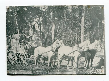
black and white photograph, late 19th - early 20th century
... The wagon is loaded with bags and is on a bush track....The wagon is loaded with bags and is on a bush track. black and white photograph ...This is a photograph of the wagon service to the Bendoc goldfields. The service commenced in 1887.This is a pictorial record of transport in the mid 18th - early 19th century. Pack horses were vital for the delivery of goods, responding to emergencies as they could travel in country inaccessible to larger horse - drawn carts or wagonA small black / white photograph of two men in a wagon pulled by a team of horses (5?). The wagon is loaded with bags and is on a bush track.transport wagon-horses -
 Orbost & District Historical Society
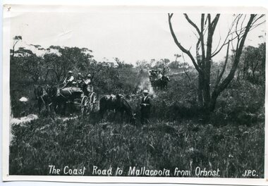
black and white photograph, late 19th century - early 20th century
... A large black / white photograph of two horse - drawn wagons on a narrow sandy bush track. It is surrounded by scrub. ...This road is still in use in East Gippsland as a part of many four-wheel-drive touring routes. on front - "The Coast Road to Mallacoota from Orbost JPC" A large black / white photograph of two horse - drawn wagons on a narrow sandy bush track. It is surrounded by scrub. ...Prior to the sealing of the Princes Highway west of Orbost, the road surface was anything but good, even by C1917 when cars started to use the road. From Orbost the old road via Marlo to Sydenham was abandoned for the new location which traversed more rugged country via Cabbage Tree, Bell Bird and Club Terrace to Cann River, and the reason for this diversion was on account of settlements being established at Murrungowar and Club Terrace, at which latter place there was a temporary rush to obtain gold. This road was constructed by the Public Works department and a maximum grade of 1 in 19 was adopted, and as speed was not to be catered for the grade followed in and out round the spurs and gullies, resulting in a maze of turns and twists which required a good deal of skill on the part of the horse driver to negotiate." - Bairnsdale Advertiser, Friday, May 2, 1947. (More information from Newsletter February 2010)n the late 1800's early 1900's transporting goods by road was difficult and at times impossible because roads as thoroughfares did not exist.The means of travelling along the roads in the 1800's was by bullock wagon, horse pulled dray, pack horse or simply by foot. This road is still in use in East Gippsland as a part of many four-wheel-drive touring routes.A large black / white photograph of two horse - drawn wagons on a narrow sandy bush track. It is surrounded by scrub. There is one man standing beside a horse not harnessed to a wagon.on front - "The Coast Road to Mallacoota from Orbost JPC" -
 Orbost & District Historical Society
black and white photograph, C1900
... The pair generally drove a four wheeled wagon pulled by five horses along a hand carved winding track through the mountains. ...The pair generally drove a four wheeled wagon pulled by five horses along a hand carved winding track through the mountains. ...Harry Ingram delivered milk, bread, groceries and meat to towns between Delegate and Orbost with his eldest son. The pair generally drove a four wheeled wagon pulled by five horses along a hand carved winding track through the mountains. This is a pictorial record of transport in the early 20th century in Orbost. It is associated with the Ingram family settlers in Orbost from 1938.A black / white photograph of a man on a horse drawn cart.on back - "Harry Ingram"ingram-harry transport-c19th -
 Orbost & District Historical Society
Photograph - Hofen's cutting, Bete Bolong, Orbost district, early 20th century
... wagon and prior to cars and railways. This is a pictorial record of early Bete Bolong showing a road through a cutting which was known as Hofen's cutting. Bete Bolong Orbost tracks ...This photograph is of a cutting on a road at Bete Bolong known as Hofen's Cutting. This photograph was taken c. 1906 when transport was by horse, wagon and prior to cars and railways.This is a pictorial record of early Bete Bolong showing a road through a cutting which was known as Hofen's cutting. Two black / white photographs showing a dirt road heading down a cutting with a post and rail wooden fence on the left side in the background. In 958.1 there is a cut - away hillside beside the dirt road.on back - "Newmerella" (note: this location is at Bete Bolong and not on Newmerella Hill) 958.1 - on back - "Hofen's Bluff 1906"bete bolong, orbost, tracks/roads -
 Orbost & District Historical Society
black and white photograph, C1947
... The pair generally drove a four wheeled wagon pulled by five horses along a hand carved winding track through the mountains....The pair generally drove a four wheeled wagon pulled by five horses along a hand carved winding track through the mountains. ...This is a photograph of Councillor Henry Ingram who represented North Riding from 1927 - 1947 on the Orbost Shire Council. Harry Ingram delivered milk, bread, groceries and meat to towns between Delegate and Orbost with his eldest son. The pair generally drove a four wheeled wagon pulled by five horses along a hand carved winding track through the mountains.This item is associated with the Orbost Shire Council. The shire covered an area of 9,347 square kilometres and existed from 1892 until 1994 when it became part of the East Gippsland Shire Council.A black / white head and shoulders portrait photograph of a man in a suit.There is also a framed photograph.on back - " Cr H. Ingram J.P. , North Riding 1929-1947"ingram-henry orbost-shire-council