Showing 217 items matching "walking tracks"
-
 Greensborough Historical Society
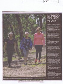
Newspaper Clipping, Diamond Valley Leader, Map risky walking tracks, 29/03/2017
... Map risky walking tracks...walking tracks...Walkers are being urged to dob in dubious walking tracks in a bid to attract funding for improvements....Map risky walking tracks Newspaper Clipping Diamond Valley Leader ...Walkers are being urged to dob in dubious walking tracks in a bid to attract funding for improvements.News article 1 page, black text, colour image.walking tracks, walkspot project, womens walking wanderers -
 Lakes Entrance Historical Society
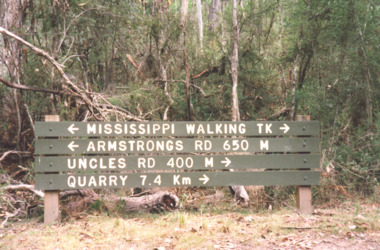
Photograph - walking tracks in Colquhoun Forest, East Gippsland c2000, Davies Judy
... walking tracks in Colquhoun Forest, East Gippsland c2000...Colour photograph of a signpost indicating Mississippi walking tracks , Armstrong Rd, Uncles Track and Quarry in Colquhoun Forest, East Gippsland. ...Plus six other photos. Photograph walking tracks in Colquhoun Forest, East Gippsland c2000 Davies Judy ...other photos taken during excursion to Colquhoun Forest same day. Pictured are Tim Gibson and Leigh Davies Colour photograph of a signpost indicating Mississippi walking tracks , Armstrong Rd, Uncles Track and Quarry in Colquhoun Forest, East Gippsland. Plus six other photos.forest, recreation, topography -
 Emerald Museum & Nobelius Heritage Park
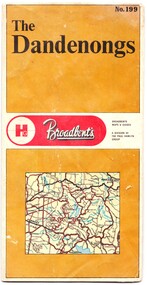
Map - Map of the Dandenongs, The Paul Hamlyn Group, c. 1970s
... ...walking tracks...This map of the Dandenongs c 1970s details tourist sites and walking tracks. ...The other side includes a street index, a list of tourist sites, a list of walking tracks, a map of Sherbrooke Forest, and a map of key approaches from the city to the Dandenongs....This map of the Dandenongs c 1970s details tourist sites and walking tracks. This map shows streets and walking tracks and tourist sites significant in the Dandenongs c. 1970s. ...George Broadbent was a Geelong-born cyclist record-holder, who produced from 1896 the most comprehensive and detailed maps of Victoria until his death in October 1947. His son had taken over map production in 1945. This map of the Dandenongs c 1970s details tourist sites and walking tracks. This map shows streets and walking tracks and tourist sites significant in the Dandenongs c. 1970s.Front of fold-out map titled 'The Dandenongs No. 199', produced by Broadbents. Folded out, one side is a street map of the Dandenongs. The other side includes a street index, a list of tourist sites, a list of walking tracks, a map of Sherbrooke Forest, and a map of key approaches from the city to the Dandenongs.On front: ' No. 199 / The / Dandenongs / Broadbents / Broadbents / Maps & Guides / A DIVISION OF / THE PAUL HAMLYN / GROUP'broadbents, dandenongs, 1970s, tourist sites, walking tracks -
 Whitehorse Historical Society Inc.
Pamphlet, Yarran Dheran Walking Tracks, 2007
... Yarran Dheran Walking Tracks...Yarran Dheran Walking Tracks Pamphlet ...Description and map of walking tracks of Yarran Dheran ReserveA4 black and white which is folded twice.non-fictionDescription and map of walking tracks of Yarran Dheran Reserveyarran dheran reserve, walking trails, quarries, schwerkolt cottage, schwerkolt august -
 Whitehorse Historical Society Inc.
Pamphlet, Yarran Dheran - walking tracks, suggested walks
... Yarran Dheran - walking tracks, suggested walks...Yarran Dheran - walking tracks, suggested walks Pamphlet Pamphlet ...Plan of Yarran Dheran with surrounding roads and suggested walks with times.Plan of Yarran Dheran with surrounding roads and suggested walks with times.Plan of Yarran Dheran with surrounding roads and suggested walks with times.yarran dheran, walks -
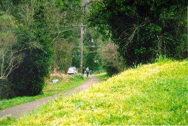
 Marysville & District Historical Society
Postcard (item) - Colour postcard, Scancolor (Australia) Pty Ltd, Marysville-Victoria-Australia-Walking track through the "Beeches", Pre 2009
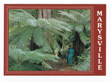
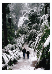
... Marysville-Victoria-Australia-Walking track through the "Beeches".......walking track...A colour photograph of a couple walking on the track through the "Beeches"....A colour photograph of a couple walking on the track through the "Beeches"....MARYSVILLE/ Victoria - Australia Walking track through the "Beeches". scancolor Australia (03) 555 1944/ CS 4067...Marysville & District Historical Society 39 Darwin Street Marysville yarra-valley-and-the-dandenong-ranges A colour photograph of a couple walking on the track through the "Beeches". A colour photograph of a couple walking on the track through the "Beeches". ...A colour photograph of a couple walking on the track through the "Beeches".A colour photograph of a couple walking on the track through the "Beeches". Starting from the spectacular Taggerty Cascades, the Beeches Rainforest Walk meanders through the ancient cool temperate rainforest of the Yarra Ranges. Dominated by Myrtle Beech trees and stands of Mountain Ash, the rainforest is home to many species of birds including lyrebirds. This postcard was produced by Scancolor Australia as a souvenir of Marysville.MARYSVILLE/ Victoria - Australia Walking track through the "Beeches". scancolor Australia (03) 555 1944/ CS 4067marysville, victoria, the beeches, walking track, scancolor australia, postcard, souvenir -
 Marysville & District Historical Society
Postcard (item) - Colour postcard, Scancolor (Australia) Pty Ltd, Marysville-Victoria-Australia-Walking track through the "Beeches", Pre 2009
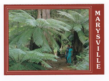
... Marysville-Victoria-Australia-Walking track through the "Beeches".......walking track...A colour photograph of a couple walking on the track through the "Beeches"....A colour photograph of a couple walking on the track through the "Beeches"....MARYSVILLE/ Victoria - Australia Walking track through the "Beeches". scancolor Australia (03) 555 1944/ CS 4067...Marysville & District Historical Society 39 Darwin Street Marysville yarra-valley-and-the-dandenong-ranges A colour photograph of a couple walking on the track through the "Beeches". A colour photograph of a couple walking on the track through the "Beeches". ...A colour photograph of a couple walking on the track through the "Beeches".A colour photograph of a couple walking on the track through the "Beeches". Starting from the spectacular Taggerty Cascades, the Beeches Rainforest Walk meanders through the ancient cool temperate rainforest of the Yarra Ranges. Dominated by Myrtle Beech trees and stands of Mountain Ash, the rainforest is home to many species of birds including lyrebirds. This postcard was produced by Scancolor Australia as a souvenir of Marysville.MARYSVILLE/ Victoria - Australia Walking track through the "Beeches". scancolor Australia (03) 555 1944/ CS 4067marysville, victoria, the beeches, walking track, scancolor australia, postcard, souvenir -
 Marysville & District Historical Society
Postcard (item) - Black and white postcard, Rose Stereograph Company, Michael Dene, Marysville, Vic, 1913-1967
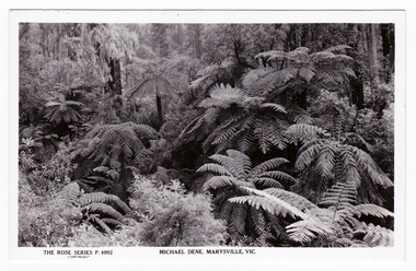
... ...walking tracks...A black and white photograph taken on the Michael Dene walking track. The Rose Series of postcards P. 4992....The track is one of several walking tracks located in and around Marysville in Victoria. michael dene walking track marysville victoria walking tracks p. 4992 rose series postcard postcard souvenir POST CARD The "Rose" Series/ De Luxe A Real Photograph/ Produced in Australia Published by the Rose Stereograph Co.,/ Armadale, Victoria. ...A postcard in a series produced by the Rose Stereograph Company in Victoria, Australia as a souvenir of Marysville.A black and white photograph taken on the Michael Dene walking track. The Michaeldene Trail to Taggerty River Lookout is a 4.3 kilometer lightly trafficked loop trail located near Marysville, Victoria. The track is one of several walking tracks located in and around Marysville in Victoria.POST CARD The "Rose" Series/ De Luxe A Real Photograph/ Produced in Australia Published by the Rose Stereograph Co.,/ Armadale, Victoria.michael dene walking track, marysville, victoria, walking tracks, p. 4992, rose series postcard, postcard, souvenir -
 Marysville & District Historical Society
Postcard (item) - Black and white postcard, Rose Stereograph Company, Michael Dene, Marysville, Vic, 1913-1967
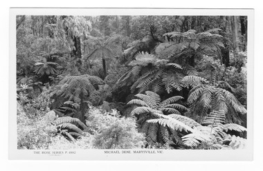
... ...walking tracks...A black and white photograph taken on the Michael Dene walking track. The Rose Series of postcards P. 4992....The track is one of several walking tracks located in and around Marysville in Victoria. michael dene walking track marysville victoria walking tracks p. 4992 rose series postcard postcard souvenir POST CARD The "Rose" Series/ De Luxe A Real Photograph/ Produced in Australia Published by the Rose Stereograph Co.,/ Armadale, Victoria. ...A postcard in a series produced by the Rose Stereograph Company in Victoria, Australia as a souvenir of Marysville.A black and white photograph taken on the Michael Dene walking track. The Michaeldene Trail to Taggerty River Lookout is a 4.3 kilometer lightly trafficked loop trail located near Marysville, Victoria. The track is one of several walking tracks located in and around Marysville in Victoria.POST CARD The "Rose" Series/ De Luxe A Real Photograph/ Produced in Australia Published by the Rose Stereograph Co.,/ Armadale, Victoria.michael dene walking track, marysville, victoria, walking tracks, p. 4992, rose series postcard, postcard, souvenir -
 Marysville & District Historical Society
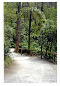
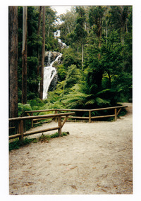
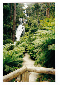
Photograph (item) - Colour photograph, Pre 2009
... A colour photograph of the walking track leading to Steavenson Falls in Marysville in Victoria....A colour photograph of the walking track leading to Steavenson Falls in Marysville in Victoria....A colour photograph of the walking track leading to Steavenson Falls in Marysville in Victoria. ...A colour photograph of the walking track leading to Steavenson Falls in Marysville in Victoria.A colour photograph of the walking track leading to Steavenson Falls in Marysville in Victoria. The Steavenson Falls is named after the Victorian Assistant Commissioner of Roads and Bridges, John Steavenson who arrived in Victoria in the early 1860s.steavenson falls, waterfalls, marysville, victoria, john steavenson -
 Marysville & District Historical Society
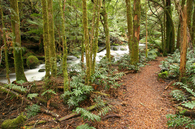
Photograph (item) - Colour photograph, 20-09-2008
... beeches rainforest walking track...A colour photograph of the Beeches Rainforest Walking Track near Marysville in Victoria....A colour photograph of the Beeches Rainforest Walking Track near Marysville in Victoria....Marysville & District Historical Society 39 Darwin Street Marysville yarra-valley-and-the-dandenong-ranges A colour photograph of the Beeches Rainforest Walking Track near Marysville in Victoria. A colour photograph of the Beeches Rainforest Walking Track near Marysville in Victoria. ...A colour photograph of the Beeches Rainforest Walking Track near Marysville in Victoria.A colour photograph of the Beeches Rainforest Walking Track near Marysville in Victoria. Starting from the spectacular Taggerty Cascades, the Beeches Rainforest Walk meanders through the ancient cool temperate rainforest of the Yarra Ranges. Dominated by Myrtle Beech trees and stands of Mountain Ash, it is home to the lyrebird which live on the forest floor.beeches rainforest walking track, marysville, victoria, taggerty river, taggerty cascades, yarra ranges, myrtle beech, mountain ash, lyrebird -
 Marysville & District Historical Society
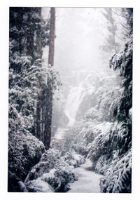
Photograph (item) - Colour photograph, Pre 2009
... A colour photograph of the walking track which leads to Steavenson Falls after a snowfall....A colour photograph of the walking track which leads to Steavenson Falls after a snowfall....A colour photograph of the walking track which leads to Steavenson Falls after a snowfall. ...A colour photograph of the walking track which leads to Steavenson Falls after a snowfall.A colour photograph of the walking track which leads to Steavenson Falls after a snowfall. The Steavenson Falls are named after the Victorian Assistant Commissioner of Roads and Bridges, John Steavenson who arrived in Victoria in the early 1860s.steavenson falls, waterfalls, marysville, victoria, snow, john steavenson -
 Marysville & District Historical Society
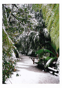
Photograph (item) - Colour photograph, 2007
... A colour photograph of the walking track which leads to Steavenson Falls after a snowfall....A colour photograph of the walking track which leads to Steavenson Falls after a snowfall....A colour photograph of the walking track which leads to Steavenson Falls after a snowfall. ...A colour photograph of the walking track which leads to Steavenson Falls after a snowfall.A colour photograph of the walking track which leads to Steavenson Falls after a snowfall. The Steavenson Falls are named after the Victorian Assistant Commissioner of Roads and Bridges, John Steavenson who arrived in Victoria in the early 1860s.March 2007 Pathway to Fallssteavenson falls, waterfalls, marysville, victoria, snow, john steavenson -
 Marysville & District Historical Society
Photograph (item) - Colour photograph, 2007
... A colour photograph of the walking track which leads to Steavenson Falls after a snowfall....A colour photograph of the walking track which leads to Steavenson Falls after a snowfall. ...A colour photograph of the walking track which leads to Steavenson Falls after a snowfall. ...A colour photograph of the walking track which leads to Steavenson Falls after a snowfall.A colour photograph of the walking track which leads to Steavenson Falls after a snowfall. The Steavenson Falls are named after the Victorian Assistant Commissioner of Roads and Bridges, John Steavenson who arrived in Victoria in the early 1860s.2007/ Steavenson Fallssteavenson falls, waterfalls, marysville, victoria, snow, john steavenson -
 Marysville & District Historical Society
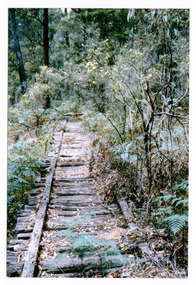
Photograph (item) - Colour photograph, Doug Orford, Unknown
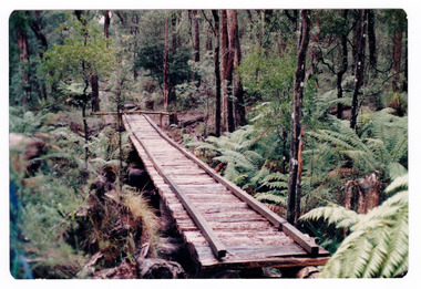
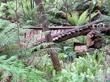
... ...walking track...A colour photograph of the timber tramway bridge along the Michaeldene Walking Track near Marysville in Victoria....A colour photograph of the timber tramway bridge along the Michaeldene Walking Track near Marysville in Victoria....The track is one of several walking tracks located in and around Marysville in Victoria. timber tramway michaeldene walking track marysville victoria walking track Doug ORFORD A colour photograph of the timber tramway bridge along the Michaeldene Walking Track near Marysville in Victoria. ...A colour photograph of the timber tramway bridge along the Michaeldene Walking Track near Marysville in Victoria.A colour photograph of the timber tramway bridge along the Michaeldene Walking Track near Marysville in Victoria. The Michaeldene Trail to Taggerty River Lookout is a 4.3 kilometer lightly trafficked loop trail located near Marysville, Victoria. The track is one of several walking tracks located in and around Marysville in Victoria.Doug ORFORDtimber tramway, michaeldene walking track, marysville, victoria, walking track -
 Halls Gap & Grampians Historical Society
Photograph - B/W, C 1960s
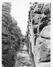
... This part of the walking track is known as "Silent Street' and forms part of the Wonderland /Pinnacle track. the photo is typical of those produced by Victorian Railways for tourism....A man is walking up the track....A man is walking up the track. Photograph B/W ...This part of the walking track is known as "Silent Street' and forms part of the Wonderland /Pinnacle track. the photo is typical of those produced by Victorian Railways for tourism.Photo shows walking track through rocky gorge. A step ladder and railings can be seen. A man is walking up the track.scenery, wonderland range -
 Marysville & District Historical Society
Photograph (item) - Colour photograph, 31-12-2008
... ...walking track...A digital copy of a colour photograph of the timber tramway bridge along the Michaeldene Walking Track near Marysville in Victoria....A digital copy of a colour photograph of the timber tramway bridge along the Michaeldene Walking Track near Marysville in Victoria....The track is one of several walking tracks located in and around Marysville in Victoria. timber tramway michaeldene walking track marysville victoria walking track A digital copy of a colour photograph of the timber tramway bridge along the Michaeldene Walking Track near Marysville in Victoria. ...A digital copy of a colour photograph of the timber tramway bridge along the Michaeldene Walking Track near Marysville in Victoria.A digital copy of a colour photograph of the timber tramway bridge along the Michaeldene Walking Track near Marysville in Victoria. The Michaeldene Trail to Taggerty River Lookout is a 4.3 kilometer lightly trafficked loop trail located near Marysville, Victoria. The track is one of several walking tracks located in and around Marysville in Victoria.timber tramway, michaeldene walking track, marysville, victoria, walking track -
 Marysville & District Historical Society
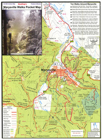
Map (Item) - Pocket map, Rooftop Mapping Services, Rooftop's Marysville Walks Pocket Map, 01-2009
... A pocket map of ten walking tracks in an around Marysville. This map was published by Rooftop Mapping Services in January 2009....A pocket map of ten walking tracks in an around Marysville. This map was published by Rooftop Mapping Services in January 2009....A pocket map of ten walking tracks in an around Marysville. marysville victoria australia rooftop mapping services steavenson falls steavenson falls car park walk beauty spot walk marysville to el kanah guest house walk gilberts gully walk michaeldene track man 'o' war walk tree fern gully walk marysville to woods lookout to mount gordon walk keppels lookout walk A pocket map of ten walking tracks in an around Marysville. ...A pocket map of ten walking tracks in an around Marysville. This map was published by Rooftop Mapping Services in January 2009.A pocket map of ten walking tracks in an around Marysville.marysville, victoria, australia, rooftop mapping services, steavenson falls, steavenson falls car park walk, beauty spot walk, marysville to el kanah guest house walk, gilberts gully walk, michaeldene track, man 'o' war walk, tree fern gully walk, marysville to woods lookout to mount gordon walk, keppels lookout walk -
 Marysville & District Historical Society
Photograph (item) - Colour photograph, Pre 2009
... A colour photograph of the walking track leading to Steavenson Falls in Marysville in Victoria....A colour photograph of the walking track leading to Steavenson Falls in Marysville in Victoria. ...A colour photograph of the walking track leading to Steavenson Falls in Marysville in Victoria. ...A colour photograph of the walking track leading to Steavenson Falls in Marysville in Victoria.A colour photograph of the walking track leading to Steavenson Falls in Marysville in Victoria. The Steavenson Falls is named after the Victorian Assistant Commissioner of Roads and Bridges, John Steavenson who arrived in Victoria in the early 1860s.Munroesteavenson falls, waterfalls, marysville, victoria, john steavenson -
 Marysville & District Historical Society
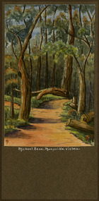
Painting (Item) - Watercolour painting, Miss I.K. Higgins, Michael Dene, Marysvile, Victoria, c1920
... michael dene walking track...A watercolour painting of the Michael Dene walking track in Marysville in Victoria....A watercolour painting of the Michael Dene walking track in Marysville in Victoria. The title of the painting is along the lower edge of the painting. ...Marysville & District Historical Society 39 Darwin Street Marysville yarra-valley-and-the-dandenong-ranges A watercolour painting of the Michael Dene walking track in Marysville in Victoria. A watercolour painting of the Michael Dene walking track in Marysville in Victoria by a Miss I.K. ...A watercolour painting of the Michael Dene walking track in Marysville in Victoria.A watercolour painting of the Michael Dene walking track in Marysville in Victoria by a Miss I.K. Higgins of Geelong in 1920. The Michaeldene Trail to Taggerty River Lookout is a 4.3 kilometer lightly trafficked loop trail located near Marysville, Victoria. The track is one of several walking tracks located in and around Marysville in Victoria.Michael.Dene.Marysville.Victoria Donated / by/ Elsie Stephens/ Mornington Painted by/ Miss I.K. Higgins/ of Geelong/ cc. 1920michael dene walking track, marysville, victoria, i.k. higgins, taggerty river -
 Marysville & District Historical Society
Photograph (item) - Colour photograph, 1996
... ...walking track...A colour photograph of the timber tramway bridge along the Michaeldene Walking Track near Marysville in Victoria....A colour photograph of the timber tramway bridge along the Michaeldene Walking Track near Marysville in Victoria. The year the photograph was taken is written on the reverse....The track is one of several walking tracks located in and around Marysville in Victoria. timber tramway michaeldene walking track marysville victoria walking track 1996 A colour photograph of the timber tramway bridge along the Michaeldene Walking Track near Marysville in Victoria. ...A colour photograph of the timber tramway bridge along the Michaeldene Walking Track near Marysville in Victoria.A colour photograph of the timber tramway bridge along the Michaeldene Walking Track near Marysville in Victoria. The Michaeldene Trail to Taggerty River Lookout is a 4.3 kilometer lightly trafficked loop trail located near Marysville, Victoria. The track is one of several walking tracks located in and around Marysville in Victoria.1996timber tramway, michaeldene walking track, marysville, victoria, walking track -
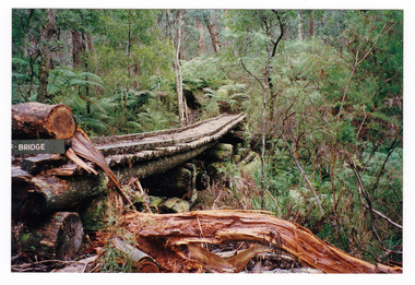
 Greensborough Historical Society
Article - Newsletter Clipping, Colin Brooks, New Local History published on Plenty River, 2023
... Article about Anne Paul's book, "Walking the Kurrum Yallock" regarding the walking tracks and heritage of the Plenty River, from Brooksy's Briefing...Printed article about book written by Anne Paul regarding th walking track and heritage of the Plenty River from Brooksy's Briefing...Greensborough Historical Society 34A Glenauburn Road Lower Plenty Lower Plenty melbourne Article about Anne Paul's book, "Walking the Kurrum Yallock" regarding the walking tracks and heritage of the Plenty River, from Brooksy's Briefing plenty river anne paul Greensborough Historical Society colin brooks Printed article about book written by Anne Paul regarding th walking track and heritage of the Plenty River from Brooksy's Briefing New Local History published on Plenty River Article Newsletter Clipping Colin Brooks ...Article about Anne Paul's book, "Walking the Kurrum Yallock" regarding the walking tracks and heritage of the Plenty River, from Brooksy's BriefingPrinted article about book written by Anne Paul regarding th walking track and heritage of the Plenty River from Brooksy's Briefingplenty river, anne paul, greensborough historical society, colin brooks -
 Marysville & District Historical Society
Photograph (item) - Colour photograph, 15-05-2008
... ...walking track...A colour photograph of the walking track that leads to Keppel Falls near Marysville in Victoria....A colour photograph of a man walking along the walking track that leads to Keppel Falls near Marysville in Victoria. ...A colour photograph of the walking track that leads to Keppel Falls near Marysville in Victoria. ...A colour photograph of the walking track that leads to Keppel Falls near Marysville in Victoria.A colour photograph of the walking track that leads to Keppel Falls near Marysville in Victoria. Keppel Falls are named after the Keppel Family who were one of Marysville's earliest pioneering families.2008 05 15keppel falls, marysville, victoria, waterfalls, walking track, keppel family -
 Marysville & District Historical Society
Photograph (item) - Colour photograph, 01-1964
... ...walking track...A colour photograph of the timber tramway bridge along the Michaeldene Walking Track near Marysville in Victoria....A colour photograph of the timber tramway bridge along the Michaeldene Walking Track near Marysville in Victoria. The month, year and location where the photograph was taken is written on the reverse in black ink....The track is one of several walking tracks located in and around Marysville in Victoria. timber tramway michaeldene walking track marysville victoria walking track MARYSVILLE JANUARY 1964 A colour photograph of the timber tramway bridge along the Michaeldene Walking Track near Marysville in Victoria. ...A colour photograph of the timber tramway bridge along the Michaeldene Walking Track near Marysville in Victoria.A colour photograph of the timber tramway bridge along the Michaeldene Walking Track near Marysville in Victoria. The Michaeldene Trail to Taggerty River Lookout is a 4.3 kilometer lightly trafficked loop trail located near Marysville, Victoria. The track is one of several walking tracks located in and around Marysville in Victoria.MARYSVILLE JANUARY 1964timber tramway, michaeldene walking track, marysville, victoria, walking track -
 Halls Gap & Grampians Historical Society
Photograph - B/W
... ...Walking track...Sheep on Zumstein McKenzie Falls walking track / Stan Parfett...Halls Gap & Grampians Historical Society Centennial Hall 117-119 Grampians Road Halls Gap grampians ACCESS ROUTES Walking track Sheep on Zumstein McKenzie Falls walking track / Stan Parfett Photo shows a sheep on Zumstein's/MacKenzie Falls track 1925 Photograph B/W ...Photo shows a sheep on Zumstein's/MacKenzie Falls track 1925Sheep on Zumstein McKenzie Falls walking track / Stan Parfettaccess routes, walking track -
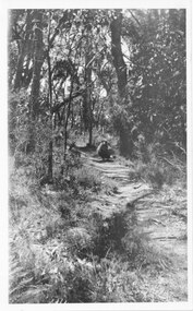
 Marysville & District Historical Society
Flyer (item) - Information Flyer, Department of Conservation, Forests & Lands, Lady Talbot Forest Drive, February 1988
... ...walking tracks...Lady Talbot Drive is named after Lady Sarah Elizabeth, the wife of Sir Reginald Talbot, who was the Governor of Victoria from 25th April, 1904 to 6th July 1908. lady talbot drive lady talbot forest drive marysville state forest sir reginald talbot lady sarah elizabeth talbot wishing well taggerty river phantom falls keppel falls beeches walking track marysville mount sugarloaf logging victoria walking tracks 7761(F1) A flyer with information on Lady Talbot Forest Drive and the attractions in the area surrounding it. ...A flyer with information on Lady Talbot Forest Drive and the attractions in the area surrounding it.A flyer with information on Lady Talbot Forest Drive and the attractions in the area surrounding it. Lady Talbot Drive a 24 kilometer scenic rainforest car journey which passes a number of walks and waterfalls in the Yarra Ranges National Park. Lady Talbot Drive is named after Lady Sarah Elizabeth, the wife of Sir Reginald Talbot, who was the Governor of Victoria from 25th April, 1904 to 6th July 1908.7761(F1)lady talbot drive, lady talbot forest drive, marysville state forest, sir reginald talbot, lady sarah elizabeth talbot, wishing well, taggerty river, phantom falls, keppel falls, beeches walking track, marysville, mount sugarloaf, logging, victoria, walking tracks -
University of Melbourne, Burnley Campus Archives
Plan, City of Hawthorn. Proposed Walking Track - Yarra Bank, Burwood to Barkers, 1986
... City of Hawthorn. Proposed Walking Track - Yarra Bank, Burwood to Barkers -......walking tracks...City of Hawthorn. Proposed Walking Track - Yarra Bank, Burwood to Barkers - Plan ...City of Hawthorn. Drawing No P26/9 dated November 1986.hawthorn, yarra bank, pridmore park reserve, walking tracks -
 Southern Sherbrooke Historical Society Inc.
Information folder - Lovers Walk, Belgrave
... ...walking tracks...Southern Sherbrooke Historical Society Inc. 127 Colby Drive Belgrave Heights 3160 yarra-valley-and-the-dandenong-ranges lovers walk mt morton walking tracks Folder containing information pertaining to the history of Lovers Walk. ...Folder containing information pertaining to the history of Lovers Walk. Contents: -5 maps showing Rights-Of_way between Belgrave and Mt Morton, Belgrave Heights, with path of Lovers Walk indicated -2 photos, reprints of Rose postcards, showing views of Lovers Walklovers walk, mt morton, walking tracks