Showing 88 items matching "walking trail"
-
 Eltham District Historical Society Inc
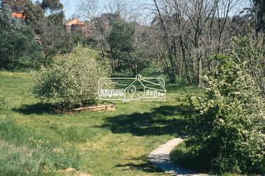
Slide - Photograph, Batman Apple tree (Malus pumila), Plenty RIver Walking Trail, Corowa Crescent, Greensborough, c.2004
... Batman Apple tree (Malus pumila), Plenty RIver Walking Trail, Corowa Crescent, Greensborough......Plenty RIver Walking Trail...Eltham District Historical Society Inc 728 Main Rd Eltham melbourne Part of a presentation on "Significant Trees, Wildflowers and Local Gardens" by Russell Yeoman to the 10 November 2004 Eltham District Historical Society meeting Batman Apple Tree Corowa Crescent Greensborough Malus pumila Plenty RIver Walking Trail Significant tree 35mm colour positive transparency Mount - white 7 dots (Technodia Italy) Batman Apple tree (Malus pumila), Plenty RIver Walking Trail, Corowa Crescent, Greensborough Slide Photograph ...Part of a presentation on "Significant Trees, Wildflowers and Local Gardens" by Russell Yeoman to the 10 November 2004 Eltham District Historical Society meeting35mm colour positive transparency Mount - white 7 dots (Technodia Italy)batman apple tree, corowa crescent, greensborough, malus pumila, plenty river walking trail, significant tree -
 Eltham District Historical Society Inc
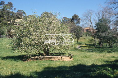
Slide - Photograph, Batman Apple tree (Malus pumila), Plenty RIver Walking Trail, Corowa Crescent, Greensborough, c.2004
... Batman Apple tree (Malus pumila), Plenty RIver Walking Trail, Corowa Crescent, Greensborough......plenty river walking trail...Eltham District Historical Society Inc 728 Main Rd Eltham melbourne Part of a presentation on "Significant Trees, Wildflowers and Local Gardens" by Russell Yeoman to the 10 November 2004 Eltham District Historical Society meeting batman apple tree corowa crescent greensborough malus pumila plenty river walking trail significant tree 35mm colour positive transparency Mount - white 7 dots (Technodia Italy) Batman Apple tree (Malus pumila), Plenty RIver Walking Trail, Corowa Crescent, Greensborough Slide Photograph ...Part of a presentation on "Significant Trees, Wildflowers and Local Gardens" by Russell Yeoman to the 10 November 2004 Eltham District Historical Society meeting35mm colour positive transparency Mount - white 7 dots (Technodia Italy)batman apple tree, corowa crescent, greensborough, malus pumila, plenty river walking trail, significant tree -
 Eltham District Historical Society Inc
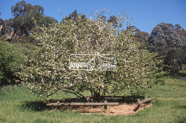
Slide - Photograph, Batman Apple tree (Malus pumila), Plenty RIver Walking Trail, Corowa Crescent, Greensborough, c.2004
... Batman Apple tree (Malus pumila), Plenty RIver Walking Trail, Corowa Crescent, Greensborough......plenty river walking trail...Eltham District Historical Society Inc 728 Main Rd Eltham melbourne Part of a presentation on "Significant Trees, Wildflowers and Local Gardens" by Russell Yeoman to the 10 November 2004 Eltham District Historical Society meeting batman apple tree corowa crescent greensborough malus pumila plenty river walking trail significant tree 35mm colour positive transparency Mount - white 7 dots (Technodia Italy) Batman Apple tree (Malus pumila), Plenty RIver Walking Trail, Corowa Crescent, Greensborough Slide Photograph ...Part of a presentation on "Significant Trees, Wildflowers and Local Gardens" by Russell Yeoman to the 10 November 2004 Eltham District Historical Society meeting35mm colour positive transparency Mount - white 7 dots (Technodia Italy)batman apple tree, corowa crescent, greensborough, malus pumila, plenty river walking trail, significant tree -
 Friends of Ballarat Botanical Gardens History Group
Work on paper - Sturt Street Statues, Ballarat's Historic Statues Walking Trail
... Ballarat's Historic Statues Walking Trail......Walking Trail...John Garner Collection Garner dr Statues Sturt St Information Centre visitor Ballarat Botanical Gardens Ballarat Gardens Walking Trail Visit Ballarat with a circular logo B Pamphlet of 2 connected A4 pages printed on both sides Ballarat's Historic Statues Walking Trail Work on paper Sturt Street Statues Ballarat ...Pamphlet made for the Ballarat Visitor Information CentreExcellent pamphlet in pictures and information attractive format.Pamphlet of 2 connected A4 pages printed on both sidesVisit Ballarat with a circular logo Bjohn garner collection, garner, dr, statues, sturt st, information centre, visitor, ballarat botanical gardens, ballarat, gardens, walking trail -
Moorabbin Air Museum
Pamphlet (Item) - Captain Ross Smith great air race 1919, The Smith Brothers Walking Trail Adelaide Airport
... The Smith Brothers Walking Trail Adelaide Airport...Moorabbin Air Museum Moorabbin Airport 12 First Street Moorabbin melbourne The Great Race 1919 The Smith Brothers Walking Trail Adelaide Airport Pamphlet Captain Ross Smith great air race 1919 ...The Great Race 1919 -
 Marysville & District Historical Society
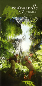
Map (Item) - Walking map, Department of Sustainability and Environment, marysville TRAILS, 07-2011
... A map showing all the walking trails in and around Marysville and the district. ...A map showing all the walking trails in and around Marysville and the district....Marysville & District Historical Society 39 Darwin Street Marysville yarra-valley-and-the-dandenong-ranges A map showing all the walking trails in and around Marysville and the district. ...A map showing all the walking trails in and around Marysville and the district. This map was produced by the Department of Sustainability and Environment in July 2011.A map showing all the walking trails in and around Marysville and the district.ISBN 978-1-74287-122-6 (print)marysville, victoria, australia, marysville trails, department of sustainability and environment, parks victoria, steavenson falls trail, beauty spot trail, gilberts gully trail, tree fern gully trail, michaeldene trail, wilks creek trail, keppel lookout trail, lady talbot drive, taggerty cascades, the beeches, keppel falls, phantom falls, cathedral range state park, cambarville, lake mountain trails, cumberland falls, mystic mountains tourism -
 Eltham District Historical Society Inc
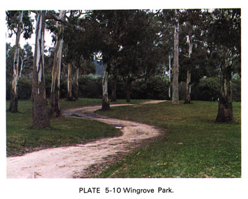
Work on paper (Sub-Item) - Photograph, Wingrove Park
... ...walking trail...Colour photograph of winding walking trail through trees at Wingrove Park. Wingrove Park in named for Eltham pioneer Charles S. ...Eltham District Historical Society Inc 728 Main Rd Eltham melbourne Colour photograph of winding walking trail through trees at Wingrove Park. Wingrove Park in named for Eltham pioneer Charles S. ...Colour photograph of winding walking trail through trees at Wingrove Park. Wingrove Park in named for Eltham pioneer Charles S. Wingrove, Secretary and Engineer to the Eltham Road Board and Shire Council, 1858-1904eltham, gum trees, eucalpypts, walking trail, wingrove park -
 The Beechworth Burke Museum
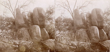
Photograph - Stereoscopic Photograph
... ...Beechworth Walking Trail...It is one of many distinct granite rock formations found along the popular Beechworth Gorge walking trail. The Sphinx rock has a hard granite core and was once buried beneath the surface of the earth. ...Sphinx Beechworth Beechworth Gorge Beechworth Walking Trail Beechworth Historic Park Obverse: 16. ...This photograph depicts The Sphinx Rock, named for its resemblance to the Egyptian Sphinx. It is one of many distinct granite rock formations found along the popular Beechworth Gorge walking trail. The Sphinx rock has a hard granite core and was once buried beneath the surface of the earth. Over time, natural weathering eroded the surrounding rock creating the unusual formations we see today. This photograph is of historic significance as an example of the unique granite outcrops located within the Beechworth Historic Park, an area of of historical significance for its relation the Victorian gold rush. The photograph serves as an important reference for the geological history of the Beechworth landscape. Sepia square stereoscopic photograph printed on matte photographic paper mounted on card.Obverse: 16. Reverse: 97.2188 / Sphinx / Beechworth / A0 3075 / 84-129-2. sphinx beechworth, beechworth gorge, beechworth walking trail, beechworth historic park -
 Eltham District Historical Society Inc
Photograph, Barak Bushlands Reserve, Eltham, March 2003, 2003
... ...walking trail...This area is urban and wetlands west of the Eltham gateway approach near the bridge over Diamond Creek and forms part of a walking trail. On 15 August 2004, the Shire of Nillumbik officially named the area "Barak Bushlands" as part of its commitment to Aboriginal reconciliation. ...Source: Aboriginal reconcilation events in Nillumbik, Ken Eckersall, 2006. barak bushlands reserve eltham walking trail Digital scan from borrowed photo Barak Bushlands Reserve, Eltham, March 2003 Photograph Photograph Jim Connor ...This area is urban and wetlands west of the Eltham gateway approach near the bridge over Diamond Creek and forms part of a walking trail. On 15 August 2004, the Shire of Nillumbik officially named the area "Barak Bushlands" as part of its commitment to Aboriginal reconciliation. The naming day memorialised the one hundred and first anniversary of the death of the last full-blood Yarra Aboriginal leader, William Barak. Source: Aboriginal reconcilation events in Nillumbik, Ken Eckersall, 2006.Digital scan from borrowed photobarak bushlands reserve, eltham, walking trail -
 Kiewa Valley Historical Society
Video - Fainter Falls, Fainter Falls, 2003 - 2008
... fainter falls. bogong. walking trail. fire track. national parks of victoria...Work to establish a 700 metre grade 2 walking trail with a 50 metre grade 3 extension trail to the Falls began in 2005. ...Work to establish a 700 metre grade 2 walking trail with a 50 metre grade 3 extension trail to the Falls began in 2005. ...Visual workings and development of the Fainter Falls Trail completed in 2008. The trail was originally accessible via a fire fighting access trail. The fire in the summer of 2003 highlighted the beauty of the area and provided the residents of the Kiewa Valley with the opportunity to consider the redevelopment of the trail. Work to establish a 700 metre grade 2 walking trail with a 50 metre grade 3 extension trail to the Falls began in 2005. It also includes 3 observation decks, a bridge over a creek crossing, car parking and interpretive signage.This video recording is a visual recording of the process of the establishment of the Fainter Falls Walking Trail giving an insight into the process, the work, tools and materials used for such work from 2003 to 2008. It also shows the vegetation in the area and the amount of water flowing at the time.White cardboard cover with black plastic video labelled "Fainter Falls" on outer edge."Fainter Falls"fainter falls. bogong. walking trail. fire track. national parks of victoria -
 Kiewa Valley Historical Society
Folder - Fainter Falls, 2003 - 2008
... fainter falls. bogong. walking trail. fire track. kiewa valley community....Work to establish a 700 metre grade 2 walking trail with a 50 metre grade 3 extension trail to the Falls began in 2005. ...Work to establish a 700 metre grade 2 walking trail with a 50 metre grade 3 extension trail to the Falls began in 2005. ...The Fainter Falls Walking Track was originally accessible via a fire fighting access trail, which was used by fire fighters putting out spot fires caused by lightening strikes. The fires in the summer of 2003 highlighted the beauty of the area and provided the residents with the opportunity to consider the redevelopment of the trail. Work to establish a 700 metre grade 2 walking trail with a 50 metre grade 3 extension trail to the Falls began in 2005. It also includes 3 observation decks, a bridge over a creek crossing, car parking and interpretive signage.A Friends of Fainter Falls committee was formed to work towards the construction of a track to Fainter Falls. The contents of this folder is evidence of how a local community achieved its goals for such a project in 2003 - 2008.Large orange lever arch folder bound with 2 rings. Contains the history of the redevelopment of the Fainter Falls track 2003 - completion at the end of 2008. It is divided into: Funding Proposals. Correspondence Inwards & Outwards. Minutes and Letters of Support. Inserted separately in a large white and yellow Express Post envelope is additional information including chronology, minutes, newspaper cuttings Inserted separately is the 'Small Towns Development Fund' Application Form 2006.Cover blankfainter falls. bogong. walking trail. fire track. kiewa valley community. -
Camberwell Historical Society
Booklet (Item), Goldsworthy, Val, Plaques and other treasures
... Booklet on plaques and monuments found along a walking trail through Camberwell ...Camberwell Historical Society 25 Inglesby Road Camberwell melbourne Camberwell Booklet on plaques and monuments found along a walking trail through Camberwell Plaques and other treasures Booklet Booklet Goldsworthy, Val ...camberwell -
 Ballarat Tramway Museum
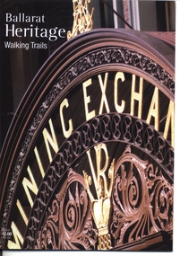
Book, City of Ballarat, "Ballarat Heritage Walking Trails", 2010
... Booklet - 36 pages, full colour photographs, titled "Ballarat Heritage Walking Trails", providing details of three heritage walking trails around the central portion of Ballarat. ...Has a map in the centre pages. The walking trails: CBD Heritage Lydiard St Heritage Sturt St statue "Ballarat Heritage Walking Trails" Book City of Ballarat ...Booklet - 36 pages, full colour photographs, titled "Ballarat Heritage Walking Trails", providing details of three heritage walking trails around the central portion of Ballarat. Gives a short description and photograph of the buildings or locations. Has a map in the centre pages. The walking trails: CBD Heritage Lydiard St Heritage Sturt St statuetrams, tramways, lydiard st, sturt st, ballarat, heritage -
Federation University Historical Collection
Booklet - Walking Guide, Ballarat Heritage Walking Guide, c2015
... ...Walking trail...Barker Library (top floor) Mount Helen goldfields Ballarat Walking trail Statues Gold Monument Sturt Street unicorn hotel Ballarat Town hall Sugg light Ballarat Post Office Camp Street Summerscales Building State Offices Police court Huyghue House Pratt's Building YMCA Ballarat Trades Hall ANA Hall maps Lydiard Street Ballarat Gaol Ballarat School of Mines Wesleyan Church Ansonia Lynn's Chambers Craig's Royal Hotel her Majesty's Theatre Union Bank Building Bank of Australasia National Bank Colonial Bank of Australasia Bank of New South Wales George Hotel Old Colonists' hall Art Gallery of Ballarat Union Fidelity Hall Goller's Warehouse Dunn's Warehouse Ludbrook House Reid's Coffe Police Ballarat Railway Station Cenotaph Queen Victoria Fountain Boer War Memorial Burke and Wills Founitain Titanic Memorial Bandstand 35 page booklet with a detail from the Mining Exchange on the front. ...35 page booklet with a detail from the Mining Exchange on the front. ballarat, walking trail, statues, gold monument, sturt street, unicorn hotel, ballarat town hall, sugg light, ballarat post office, camp street, summerscales building, state offices, police court, huyghue house, pratt's building, ymca, ballarat trades hall, ana hall, maps, lydiard street, ballarat gaol, ballarat school of mines, wesleyan church, ansonia, lynn's chambers, craig's royal hotel, her majesty's theatre, union bank building, bank of australasia, national bank, colonial bank of australasia, bank of new south wales, george hotel, old colonists' hall, art gallery of ballarat, union fidelity hall, goller's warehouse, dunn's warehouse, ludbrook house, reid's coffe police, ballarat railway station, cenotaph, queen victoria fountain, boer war memorial, burke and wills founitain, titanic memorial bandstand -
Federation University Historical Collection
Booklet - Walking Guide, Lyne Reading et al, Five Easy Walks Around Ballarat, c2010
... Walking trail...Barker Library (top floor) Mount Helen goldfields Walking trail Ballarat Botanical Gardens Lake Wendouree Eureka trail Eureka Stockade Yarrowee River Walk Nerrina Wetlands 30 page booklet with Five Easy Walks Around Ballarat Booklet Walking Guide Lyne Reading Yvonne Fix Meredith Tangey ...30 page booklet withwalking trail, ballarat botanical gardens, lake wendouree, eureka trail, eureka stockade, yarrowee river walk, nerrina wetlands -
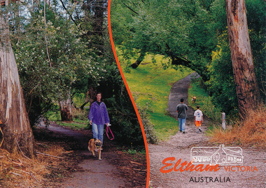 Eltham District Historical Society Inc
Postcard, Alistair Knox Park, Eltham, Victoria, Australia, 2015c
... ...walking...trail...Eltham District Historical Society Inc 728 Main Rd Eltham melbourne eltham alistair-knox-park walking trail postcard Postcard showing two views of people walking dogs through the park. ...Postcard showing two views of people walking dogs through the park. Mel: 21 J6eltham, alistair-knox-park, walking, trail, postcard -
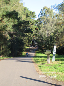 Eltham District Historical Society Inc
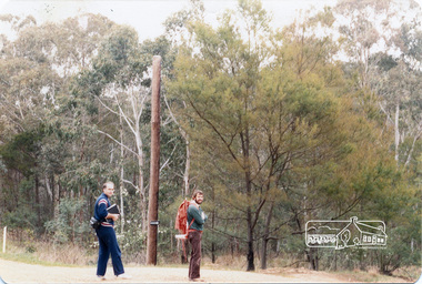
Photograph, Liz Pidgeon, Heritage Excursion; Eltham Lower Park Walk and Talk, 1 July 2017, 1 July 2017
... ...walking...trail...(Melway ref 21 H 10). heritage excursion activities eltham district historical society eltham lower park walking trail Born Digital Heritage Excursion; Eltham Lower Park Walk and Talk, 1 July 2017 Photograph Photograph Liz Pidgeon ...Newsletter No., 234, June 2017 Heritage Excursion - Saturday 1st July - Eltham Lower Park - Walk and Talk Eltham Lower Park has played an important part in the history of our area since the early days of European settlement when it was used by local residents as an informal racecourse. Prior to that its location at the junction of the Diamond Creek and the Yarra River made it an important meeting place for the Wurundjeri people. The park combines formal elements and sporting facilities with remnant bushland that is of environmental significance. It is home to sporting and horse riding clubs, popular play spaces and the Diamond Valley Miniature Railway, which attracts large numbers of visitors. The park will be the venue for our July excursion which will comprise a walk of about 3.5 km around the park and adjacent areas. Along the way we will discuss the history and natural history of the area. The path along the creek and the river provides a pleasant and scenic walk. This walk on Saturday 1st July is about 3.5 km in length and will take 2 to 2.5 hours. It will start at 2pm at the Main Road car park at the front of the park. (Melway ref 21 H 10). Born Digitalheritage excursion, activities, eltham district historical society, eltham lower park, walking, trail -
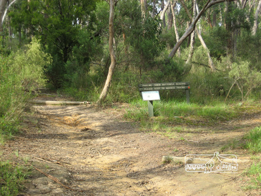 Eltham District Historical Society Inc
Photograph, Liz Pidgeon, Pauline Toner Butterfly Reserve, Eltham, 18 February 2011, 18 February 2011
... ...walking trail...It is named for Pauline Toner M.P. who after the re-discovery of the rare Eltham copper Butterfly in large numbers in Eltham in 1987 worked to preserve its habitat. pauline toner reserve eucalyptus road copper butterfly nature reserve walking trail sign erosion Born Digital Pauline Toner Butterfly Reserve, Eltham, 18 February 2011 Photograph Photograph Liz Pidgeon ...Signage in the Pauline Toner Butterfly Reserve asking visitors to keep to marked tracks. The Reserve at the corner of Pitt Street and Eucalyptus Road, Eltham is managed by Parks Victoria. It is named for Pauline Toner M.P. who after the re-discovery of the rare Eltham copper Butterfly in large numbers in Eltham in 1987 worked to preserve its habitat.Born Digitalpauline toner reserve, eucalyptus road, copper butterfly, nature reserve, walking trail, sign, erosion -
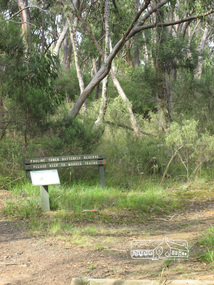 Eltham District Historical Society Inc
Photograph, Liz Pidgeon, Pauline Toner Butterfly Reserve, Eltham, 18 February 2011, 18 February 2011
... ...walking trail...It is named for Pauline Toner M.P. who after the re-discovery of the rare Eltham copper Butterfly in large numbers in Eltham in 1987 worked to preserve its habitat. pauline toner reserve eucalyptus road copper butterfly walking trail sign nature reserve Born Digital Pauline Toner Butterfly Reserve, Eltham, 18 February 2011 Photograph Photograph Liz Pidgeon ...Signage in the Pauline Toner Butterfly Reserve asking visitors to keep to marked tracks. The Reserve at the corner of Pitt Street and Eucalyptus Road, Eltham is managed by Parks Victoria. It is named for Pauline Toner M.P. who after the re-discovery of the rare Eltham copper Butterfly in large numbers in Eltham in 1987 worked to preserve its habitat. Born Digitalpauline toner reserve, eucalyptus road, copper butterfly, walking trail, sign, nature reserve -
 Eltham District Historical Society Inc
Photograph, Long Gully and environs, Watsons Creek catchment, c.Oct 1982, 1982
... Looking for a route for a walking trail from Kinglake to the Yarra River. ...Eltham District Historical Society Inc 728 Main Rd Eltham melbourne Looking for a route for a walking trail from Kinglake to the Yarra River. ...Looking for a route for a walking trail from Kinglake to the Yarra River. Not shown is Rod Roscholler. Colour photograph1982, long gully, watsons creek, lodi francesconi, russell yeoman -
 Stawell Historical Society Inc
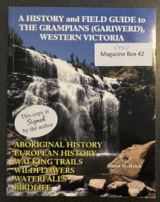
Book - History and Field Guide, David M. Welch, A History and Field Guide to the Grampians (Gariwerd) Western Victoria, 2021
... Aboriginal History, European History, walking Trails, Wild Flowers, waterfalls, Bird Life....Aboriginal History, European History, walking Trails, Wild Flowers, waterfalls, Bird Life. ...Aboriginal History, European History, walking Trails, Wild Flowers, waterfalls, Bird Life.Soft Cover: Colour Photo on the front: Waterfall. on the rear RockartThis copy is signed by the author: Best Wishes David M Welch. See context -
Whitehorse Historical Society Inc.
Map, Yarran Dheran Reserve, n.d
... A pen and ink drawing on laminated plasticised paper of the walking trails from Yarran Dheran to Schwerkolt Cottage...Whitehorse Historical Society Inc. 2-10 Deep Creek Road Mitcham melbourne A pen and ink drawing on laminated plasticised paper of the walking trails from Yarran Dheran to Schwerkolt Cottage Yarran Dheran Schwerkolt Cottage Walking Trails Yarran Dheran Walking Trail Yarran Dheran Reserve Map ...Yarran Dheran Walking Trailnon-fictionYarran Dheran Walking Trailyarran dheran, schwerkolt cottage, walking trails -
 Bendigo Historical Society Inc.
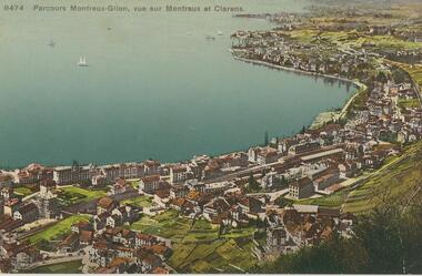
Postcard - ROY AND DORIS KELLY COLLECTION: PARCOURS MONTREUX-GLION, VUE SUR MONTREUX ET CLARENS, 1900-1920
... The railway station in the centre is the start point for the Montreux to Glion walking trail. Photo taken on hillside overlooking Montreux and the suburb Clarens. ...The railway station in the centre is the start point for the Montreux to Glion walking trail. Photo taken on hillside overlooking Montreux and the suburb Clarens. ...Postcard, coloured photo of Montreux on the shores of Lake Geneva, Switzerland. The railway station in the centre is the start point for the Montreux to Glion walking trail. Photo taken on hillside overlooking Montreux and the suburb Clarens. Four sailing ships on the bay.postcard, photograph, postcard, montreux, lake geneva, clarens, switzerland -
 Eltham District Historical Society Inc
Photograph, Liz Pidgeon, Heritage Excursion; Eltham Lower Park Walk and Talk, 1 July 2017, 1 July 2017
... walking...diamond creek trail...Walking along the shared pathway of the Diamond Creek Trail Newsletter No., 234, June 2017 Heritage Excursion - Saturday 1st July - Eltham Lower Park - Walk and Talk Eltham Lower Park has played an important part in the history of our area since the early days of European settlement when it was used by local residents as an informal racecourse. ...(Melway ref 21 H 10). heritage excursion activities eltham district historical society eltham lower park walking diamond creek trail shared pathway Born Digital Heritage Excursion; Eltham Lower Park Walk and Talk, 1 July 2017 Photograph Photograph Liz Pidgeon ...Walking along the shared pathway of the Diamond Creek Trail Newsletter No., 234, June 2017 Heritage Excursion - Saturday 1st July - Eltham Lower Park - Walk and Talk Eltham Lower Park has played an important part in the history of our area since the early days of European settlement when it was used by local residents as an informal racecourse. Prior to that its location at the junction of the Diamond Creek and the Yarra River made it an important meeting place for the Wurundjeri people. The park combines formal elements and sporting facilities with remnant bushland that is of environmental significance. It is home to sporting and horse riding clubs, popular play spaces and the Diamond Valley Miniature Railway, which attracts large numbers of visitors. The park will be the venue for our July excursion which will comprise a walk of about 3.5 km around the park and adjacent areas. Along the way we will discuss the history and natural history of the area. The path along the creek and the river provides a pleasant and scenic walk. This walk on Saturday 1st July is about 3.5 km in length and will take 2 to 2.5 hours. It will start at 2pm at the Main Road car park at the front of the park. (Melway ref 21 H 10). Born Digitalheritage excursion, activities, eltham district historical society, eltham lower park, walking, diamond creek trail, shared pathway -
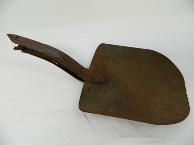 Kiewa Valley Historical Society
Shovel head - Fainter Falls
... Work to establish a 700 metre grade 2 walking trail with a 50 metre grade 3 extension trail to the Falls began in 2005. ...Work to establish a 700 metre grade 2 walking trail with a 50 metre grade 3 extension trail to the Falls began in 2005. ...The Fainter Falls Walking Track was originally accessible via a fire fighting access trail, which was used by fire-fighters putting out spot fires caused by lightening strikes. The fires in the summer of 2003, highlighted the beauty of this area and provided the residents with the opportunity to consider the redevelopment of the trail. Work to establish a 700 metre grade 2 walking trail with a 50 metre grade 3 extension trail to the Falls began in 2005. It also includes 3 observation decks, a bridge over a creek crossing, car parking and interpretative signage.The shovel was found during work on the Fainter Falls track. It was left there some time ago by a previous visitor to the Falls indicating that the Falls were accessible and attracted visitors many years ago.Rusty metal shovel head curved on each side and rounded at the front. At the back of the blade it is attached on top with 3 nails to the top piece. The top metal piece overlaps the blade by 6.5 cm longitudinally x 5 cm across. On the back the metal piece overlaps the blade by 12 cm both longitudinally and across the handle end but tapers to a point. It has 6 nails attaching it. Both metal pieces are attached to the blade and curve parallel and around so that a wooden handle would fit between them. This would have 2 nails passing through both metal pieces and the handle. (The handle is missing.) shovel. fainters falls. bogong. walking track. fire track. water. -
 Parks Victoria - Mount Buffalo Chalet
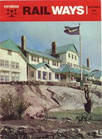
Magazine, "Victorian Railways November 1974"
... 'Over the years the VR Advertising Division published a number of booklets promoting Mount Buffalo's sports and restorative powers of its scenery in summer and winter...The collection (MBCC) comprises a good range of tourist writing published as promotional booklets, guidebooks, brochures, walking trails, maps and newspaper articles.' (Pg. 119. ...Parks Victoria - Mount Buffalo Chalet Mount Buffalo Road Mount Buffalo National Park Mt Buffalo high-country 'Over the years the VR Advertising Division published a number of booklets promoting Mount Buffalo's sports and restorative powers of its scenery in summer and winter...The collection (MBCC) comprises a good range of tourist writing published as promotional booklets, guidebooks, brochures, walking trails, maps and newspaper articles.' (Pg. 119. ...'Over the years the VR Advertising Division published a number of booklets promoting Mount Buffalo's sports and restorative powers of its scenery in summer and winter...The collection (MBCC) comprises a good range of tourist writing published as promotional booklets, guidebooks, brochures, walking trails, maps and newspaper articles.' (Pg. 119. Historica) This Victorian Railways monthly publication and also the VR Newsletter, published by the Victorian Railways Printing Works in North Melbourne, is one of a number which featured iconic photos of the Chalet of the plateau on its cover, as an identifiable flagship for The Victorian Railways and it's employees from the Railways Refreshment and Services Branch. These publications also have stories regarding upgrades and on long serving staff of the Chalet.Listed in Draft Inventory of Significant Collection Items . Appendix A.3. Promotional material.. (Pg 168. Historica).Railways magazine featuring an image of the chalet on the front cover and an article about the Chalet.Yes -
 Eltham District Historical Society Inc
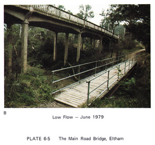
Work on paper (Sub-Item) - Photograph, Main Road Bridge, Eltham low flow of Diamond Creek, June 1979
... Colour photograph.Main Road Bridge, Eltham low flow of Diamond Creek with wooden pedestrain bridge constructed over the creek as a continuation of the walking and biking trail, June 1979...Eltham District Historical Society Inc 728 Main Rd Eltham melbourne Colour photograph.Main Road Bridge, Eltham low flow of Diamond Creek with wooden pedestrain bridge constructed over the creek as a continuation of the walking and biking trail, June 1979 diamond creek eltham bridge main road pedestrain bridge trail Image printed on A4 page from 04997 Diamond Creek Basin Study, 1980 Main Road Bridge, Eltham low flow of Diamond Creek, June 1979 Work on paper Photograph ...Colour photograph.Main Road Bridge, Eltham low flow of Diamond Creek with wooden pedestrain bridge constructed over the creek as a continuation of the walking and biking trail, June 1979diamond creek, eltham, bridge, main road, pedestrain bridge, trail -
 Kew Historical Society Inc
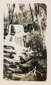
Photograph - Grampians, 1924
... This photo is of one of a waterfall on one of the walking trails. ...This photo is of one of a waterfall on one of the walking trails. Photograph Grampians ...Henry Beater Christian (1886-1962) , was a descendant of one of the earliest settler families in Kew. Employed at the Kew Asylum as a 'public servant', he was a skilled amateur photographer, photographing numerous scenes in Kew and on his travels around Victoria. The majority of his photographs date from 1916 to 1929. His finest photographs are housed in two photograph albums. Digital copy of a photograph from page 13 of the 47-page photograph album containing 261 gelatinous silver images, loaned by Diane Washfold with permission given to digitise and hold a copy in our collection. The first and last pages in the album document the Yarra River at Studley Park and at Kew. The remainder of the album includes photographs of walking and car tours in rural Victoria including 'wilderness' areas in the Grampians, Gippsland and the High Country. Six album pages document a camping trip by Henry Christian to the Grampians in September 1924. The photos include pictures of lookouts, and natural features including rock faces and waterfalls, as well as his camp site. This photo is of one of a waterfall on one of the walking trails. Unitled [Grampians]henry beater christian (1886-1962), landscape photography, christian-washfold collection, photograph albums, grampians, gariwerd -
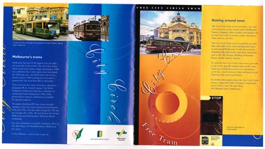 Melbourne Tram Museum
Pamphlet, Public Transport Corporation (PTC), "Free City Circle Tram", mid 1990's
... Has information about Melbourne trams, the Melbourne Town Hall, Visitor Information, Walking Trails, a map of the route, with places of interest shown. ...Has information about Melbourne trams, the Melbourne Town Hall, Visitor Information, Walking Trails, a map of the route, with places of interest shown. ...Pamphlet - eight fold to DL size, full colour, titled "Free City Circle Tram" with a photo of a City Circle tram passing Flinders St station. Has information about Melbourne trams, the Melbourne Town Hall, Visitor Information, Walking Trails, a map of the route, with places of interest shown. Map shows the service via Spencer St. Has photos of 2013 and 909 as well. Has the City of Melbourne, Department of Infrastructure and Public Transport Corporation logos. Possible produced during the mid 1990's given the various logos used. .1 - As above, but with Yarra Trams and State Government logos See Reg Items 1387 and 2703 for other versions.trams, tramways, city circle, melbourne, public transport corporation, ptc -
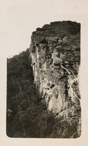 Kew Historical Society Inc
Photograph - Grampians, 1924
... This photo is of one of a well-known cliff face on one of the walking trails. ...This photo is of one of a well-known cliff face on one of the walking trails. Photograph Grampians ...Henry Beater Christian (1886-1962) , was a descendant of one of the earliest settler families in Kew. Employed at the Kew Asylum as a 'public servant', he was a skilled amateur photographer, photographing numerous scenes in Kew and on his travels around Victoria. The majority of his photographs date from 1916 to 1929. His finest photographs are housed in two photograph albums. Digital copy of a photograph from page 13 of the 47-page photograph album containing 261 gelatinous silver images, loaned by Diane Washfold with permission given to digitise and hold a copy in our collection. The first and last pages in the album document the Yarra River at Studley Park and at Kew. The remainder of the album includes photographs of walking and car tours in rural Victoria including 'wilderness' areas in the Grampians, Gippsland and the High Country. Six album pages document a camping trip by Henry Christian to the Grampians in September 1924. The photos include pictures of lookouts, and natural features including rock faces and waterfalls, as well as his camp site. This photo is of one of a well-known cliff face on one of the walking trails. Unitled [Grampians]henry beater christian (1886-1962), landscape photography, christian-washfold collection, photograph albums, grampians, mt victory, gariwerd