Showing 7 items matching "warburton ranges tourism"
-
 Marysville & District Historical Society
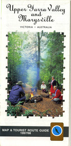
Map (Item) - Tourist map and guide, Warburton Ranges Tourism, Upper Yarra Valley and Marysville VICTORIA-AUSTRALIA, 1997
... ...warburton ranges tourism...A tourist map and guide for the Upper Yarra Valley and Marysville produced by Warburton Ranges Tourism and Mystic Mountains Tourism in 1997....A tourist map and guide for the Upper Yarra Valley and Marysville produced by Warburton Ranges Tourism and Mystic Mountains Tourism in 1997....Warburton Ranges Tourism...Upper Yarra Valley and Marysville VICTORIA-AUSTRALIA Map Tourist map and guide. Warburton Ranges Tourism Mystic Mountains Tourism Ern Mainka ...A tourist map and guide for the Upper Yarra Valley and Marysville produced by Warburton Ranges Tourism and Mystic Mountains Tourism in 1997.A tourist map and guide for the Upper Yarra Valley and Marysville produced by Warburton Ranges Tourism and Mystic Mountains Tourism in 1997.marysville, victoria, australia, tourist map, tourist guide, mystic mountains tourism, warburton ranges tourism, lake mountain, marysville post shop, the marysville museum, bruno's art and sculpture garden, marylands country house, blackwood cottages, dalrymples guest cottages, anastasia's cottage, marysville hotel motel, kerami guest house, the cumberland -
 Kiewa Valley Historical Society
Maps - Tourist
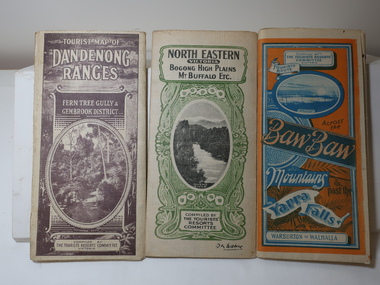
... Tourism Maps Bogong High Plains Map 1933 snow poles By Authority of H.J. Green - 6 pence. Dept of Lands and Survey, Melbourne 3 Tourist location maps (folded) and printed on parchment. 1. Tourist map of the Dandenong Ranges. Brown cover. dated 6-4-33. Govt. printer showing roads, tracks in red and heights of the land. 2. Tourist Map of Warburton ...These maps were all dated 1933 which was before the construction of the Kiewa Hydro Electric Scheme and when Tawonga was spelt Towonga. North East Victoria in 1933 was before the construction of the Kiewa Hydro Electric Scheme so the townships of Mt Beauty and Bogong are not shown. The description of the Snow Lines was important as skiers, bushwalkers and campers relied on them. The details on the map include "ADB. Numbered from A.1-377 round plates. CD Numbered from C 1-235 square plates. Poles about 3 chains apart 27 to the mile." 3 Tourist location maps (folded) and printed on parchment. 1. Tourist map of the Dandenong Ranges. Brown cover. dated 6-4-33. Govt. printer showing roads, tracks in red and heights of the land. 2. Tourist Map of Warburton, Mt Baw Baw, and Walhalla. Blue and Orange cover. dated 23-5-33 Govt. printer. 3 different maps of each area showin roads, tracks and timber tramways.Also in red and blue. 3. Tourist Map of North Eastern Victoria including Bogong High Plains Mt Buffalo Etc. Green cover. dated June 1933 Govt. printer. Main map and insert titled Bogong High Plains. Showing roads , tracks and tram ways. On insert showing snow poles. Also Red and Blue and mountains.By Authority of H.J. Green - 6 pence. Dept of Lands and Survey, Melbourne1933 maps, tourism maps, bogong high plains map 1933, snow poles -
 Marysville & District Historical Society
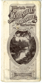
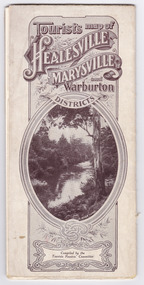
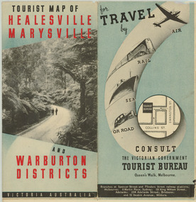
Map (Item) - Tourist Map, Tourists Resorts' Committee, Tourist's Map of Healesville Marysville and Warburton Districts, 13.10.1925
... ranges A tourist map for Healesville, Marysville and Warburton that was produced by the Tourists Resorts' Committee. This map was produced in 1925. A tourist map for Healesville, Marysville and Warburton that was produced by the Tourists Resorts' Committee. healesville marysville warburton victoria tourists resorts' committee ben cairn mount donna buang the black's spur the acheron valley narbethong launching place tourist information tourism map tourist map Photo Lithographed at the Department of Lands and Survey, Melbourne by W.J. ...A tourist map for Healesville, Marysville and Warburton that was produced by the Tourists Resorts' Committee. This map was produced in 1925.A tourist map for Healesville, Marysville and Warburton that was produced by the Tourists Resorts' Committee.Photo Lithographed at the Department of Lands and Survey, Melbourne by W.J. Butson./ 13.10.25healesville, marysville, warburton, victoria, tourists resorts' committee, ben cairn, mount donna buang, the black's spur, the acheron valley, narbethong, launching place, tourist information, tourism, map, tourist map -
 Marysville & District Historical Society
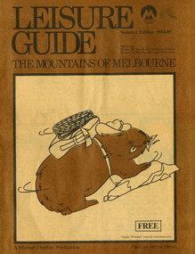
Magazine (Item) - Leisure guide, Michael Cheshire, LEISURE GUIDE THE MOUNTAINS OF MELBOURNE, 1984
... Range. This was produced by Michael Cheshire as a free publication to promote Melbourne tourism. The magazine featured Healesville, Marysville, Warburton, Eildon, Alexandra, the Upper Yarra area, and includes information on wineries in the district. ...Range. This was produced by Michael Cheshire as a free publication to promote Melbourne tourism. The magazine featured Healesville, Marysville, Warburton, Eildon, Alexandra, the Upper Yarra area, and includes information on wineries in the district. ...A leisure guide to the mountains of Melbourne beginning in the eastern suburbs, going through the Yarra Valley and into the Great Dividing Range. This was produced by Michael Cheshire as a free publication to promote Melbourne tourism. The magazine featured Healesville, Marysville, Warburton, Eildon, Alexandra, the Upper Yarra area, and includes information on wineries in the district. It was released in the summer of 1984-1985.A leisure guide to the mountains of Melbourne beginning in the eastern suburbs, going through the Yarra Valley and into the Great Dividing Range.Summer Edition 1984-85 Featuring:/ Healesville, Marysville, Warburton, Eildon,/ Alexandra, Wineries and Upper Yarra Area.healesville, warburton, eildon, alexandra, upper yarra, marysville, victoria, australia, leisure guide, michael cheshire, blackwood holiday flats, black spur motel and caravan park, tudor lodge road house, nanda binya lodge, marysville caravan park, marysville recreation and fun park, scenic motel, the tower motel, the cumberland, cathedral restaurant, cathedral restaurant gallery, taggerty golf course, taggerty holiday units, marylyn guest house -
 Marysville & District Historical Society
Map (Item) - Tourist Map, Tourists Resorts' Committee, Tourist's Map of Healesville Marysville and Warburton Districts, 13.10.1925
... ranges A tourist map for Healesville, Marysville and Warburton that was produced by the Tourists Resorts' Committee. This map was produced in 1925. A tourist map for Healesville, Marysville and Warburton that was produced by the Tourists Resorts' Committee. healesville marysville warburton victoria tourists resorts' committee ben cairn mount donna buang the black's spur the acheron valley narbethong launching place tourist information tourism map tourist map Photo Lithographed at the Department of Lands and Survey, Melbourne by W.J. ...A tourist map for Healesville, Marysville and Warburton that was produced by the Tourists Resorts' Committee. This map was produced in 1925.A tourist map for Healesville, Marysville and Warburton that was produced by the Tourists Resorts' Committee.Photo Lithographed at the Department of Lands and Survey, Melbourne by W.J. Butson./ 13.10.25healesville, marysville, warburton, victoria, tourists resorts' committee, ben cairn, mount donna buang, the black's spur, the acheron valley, narbethong, launching place, tourist information, tourism, map, tourist map -
 Marysville & District Historical Society
Map (Item) - Tourist Map, Department of Lands & Survey, Tourist Map of Healesville, Marysville and Warburton Districts, 1938
... ranges A tourist map for Healesville, Marysville and Warburton that was produced by the Victorian Department of Crown Lands and Survey, in conjunction with Victorian Railways, in 1938. A tourist map for Healesville, Marysville and Warburton that was produced by the Victorian Department of Crown Lands and Survey, in conjunction with Victorian Railways, in 1938. healesville marysville warburton victoria tourist information tourism map tourist map victorian deparment of crown lands and survey victorian railways betterment and publicity board Compiled by the Department of Lands and Survey, Melbourne Issued by the Betterment and Publicity Board, Victorian Railways, Melbourne, Victoria. ...A tourist map for Healesville, Marysville and Warburton that was produced by the Victorian Department of Crown Lands and Survey, in conjunction with Victorian Railways, in 1938.A tourist map for Healesville, Marysville and Warburton that was produced by the Victorian Department of Crown Lands and Survey, in conjunction with Victorian Railways, in 1938.Compiled by the Department of Lands and Survey, Melbourne Issued by the Betterment and Publicity Board, Victorian Railways, Melbourne, Victoria. May 1938healesville, marysville, warburton, victoria, tourist information, tourism, map, tourist map, victorian deparment of crown lands and survey, victorian railways, betterment and publicity board -
 Mont De Lancey
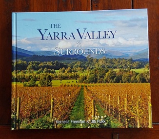
Book, Kornelia Freeman et al, The Yarra Valley & Surrounds, 2011
... Ranges - History Tourism Victoria Just over an hour’s drive from central Melbourne, the Yarra Valley is Victoria’s premier cold-climate wine region. It offers a mix of world-class wineries, artisanal farm gates, and lush, mountainous hinterlands that stretch into the Dandenong Ranges and the foothills of the Victorian Alps. Outside of Melbourne, settlement in the Yarra Valley represented a very significant segment in the history and economic development of the state of Victoria. In the 1850s, the region was on the bustling route to the Warburton ...Just over an hour’s drive from central Melbourne, the Yarra Valley is Victoria’s premier cold-climate wine region. It offers a mix of world-class wineries, artisanal farm gates, and lush, mountainous hinterlands that stretch into the Dandenong Ranges and the foothills of the Victorian Alps. Outside of Melbourne, settlement in the Yarra Valley represented a very significant segment in the history and economic development of the state of Victoria. In the 1850s, the region was on the bustling route to the Warburton goldfields. The Yarra River was also the main traffic path for the timers industry during the 1890s, as such, it was developed as the primary food production region for Melbourne.A colourful covered book showing a scene of beautiful vineyards in autumn in the Yarra Valley and surrounds approximately 40km from Melbourne. The title is printed in blue and white lettering at the top with the two authors listed below. The spine has the title, authors and M symbol for Melbourne Publishers. The title page has the same information with Portraits of Victoria added at the bottom right. There is a Contents, Introduction and then in alphabetical order, stunning photographs and detailed information about each place. At the back is an Acknowlegments and Directory of places of interest. It provides a comprehensive guide to the region's top spots—such as Healesville Sanctuary, the giant Redwoods, and local wineries—through 173 pages of stunning photography and history.non-fictionJust over an hour’s drive from central Melbourne, the Yarra Valley is Victoria’s premier cold-climate wine region. It offers a mix of world-class wineries, artisanal farm gates, and lush, mountainous hinterlands that stretch into the Dandenong Ranges and the foothills of the Victorian Alps. Outside of Melbourne, settlement in the Yarra Valley represented a very significant segment in the history and economic development of the state of Victoria. In the 1850s, the region was on the bustling route to the Warburton goldfields. The Yarra River was also the main traffic path for the timers industry during the 1890s, as such, it was developed as the primary food production region for Melbourne.dandenong ranges - victoria, dandenong ranges - history, tourism victoria