Showing 9 items matching "water quality issues"
-
 Marysville & District Historical Society
THE TRIANGLE NEWS-VOL 36 NO 5-FEBRUARY 21 2009
... ...water quality issues...Marysville & District Historical Society 39 Darwin Street Marysville yarra-valley-and-the-dandenong-ranges marysville victoria australia suspicious fires appeal murrindindi mill area marysville & district lions together fire survivors payments of water accounts extended victorian bushfire case manangment service church notices puppies found at marysville deadline disclaimer archive of local photographs dave nicholson graham eddy marysville & district historical society memorabilia & photographs needed narby bushdance relocation the black spur inn fire related enquiries water quality issues letter to the editor other help dr margaret miller fuel at igloo house dhs & racv insurance claims buxton reserve free food new & secondhand clothing buxton hall mail held at healesville post office THE TRIANGLE NEWS-VOL 36 NO 5-FEBRUARY 21 2009 ...marysville, victoria, australia, suspicious fires appeal, murrindindi mill area, marysville & district lions together, fire survivors, payments of water accounts extended, victorian bushfire case manangment service, church notices, puppies found at marysville, deadline, disclaimer, archive of local photographs, dave nicholson, graham eddy, marysville & district historical society, memorabilia & photographs needed, narby bushdance relocation, the black spur inn, fire related enquiries, water quality issues, letter to the editor, other help, dr margaret miller, fuel at igloo house, dhs & racv insurance claims, buxton reserve, free food, new & secondhand clothing, buxton hall, mail held at healesville post office -
University of Melbourne, Burnley Campus Archives
Map, Kororoit Creek Proposed ..... [words obscured], 1998
... Legend includes: Vegetation, Drainage and Flood Management Issues and Action, Water Quality, Stream System V? Issues, Primary Objectives (partially obscured).... and Action, Water Quality, Stream System V? Issues, Primary Objectives (partially obscured). ...Composite photocopy so title partly obscured, by Thompson Berrill Landscape Design DWC No KC 13 Sheet 13 of 14 dated March 1998. Scale 1:200. Legend includes: Vegetation, Drainage and Flood Management Issues and Action, Water Quality, Stream System V? Issues, Primary Objectives (partially obscured).thompson berrill, landscape design, kororoit creek, water quality, vegetation -
 Ballarat Heritage Services
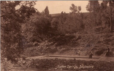
Photograph - Photograph - Black and White, Sutton Spring, Daylesford
... Unfortunately due to ongoing water quality issues, public access to take water from the trench was closed, however the trench can still be viewed....Unfortunately due to ongoing water quality issues, public access to take water from the trench was closed, however the trench can still be viewed. ...Emerging from the base of Wombat Creek Sutton Spring has two mineral water pumps. The spring is named after the Sutton brothers of Cornwell, who discovered it while looking for alluvial gold along Wombat Creek in the 1850s. By 1900, a trench had been dug to expose the spring, and a pipe had been driven through the spring eye. Sandstone rockwork encircled the trench. On 27 February 1907 the Sutton Mineral Spring Reserve was gazetted. By that time the trench had been enlarged and rendered, and a lean-to shelter had been built over the approach track. In 1927 Wombat Creek was rerouted allowing the land around the spring to be cleared and pipework repaired. Five bores were dug in 1929 and equipped with hand pumps. The bores were all shallower than 9.7 m. An attempt was made to replace one of these bores with a new bore, however it was not possible due to ground instability. These two bores are the oldest of all the mineral springs open to the public. Also in 1929 Council contemplated encouraging private enterprise to establish a ‘hydrobath’ similar to those in Europe, after mineral water had been discovered flowing from several other vents in sandstone and slate strata below the typical level of the creek. However, the option was not enacted although at the time to capture the flow another bore to a depth of 15m was sunk. In 1936 architect P. Scott Williams adopted a similar notion and examined the prospect of establishing a Hydropathic establishment above Sutton Springs, assuming a reliable mineral water supply could be found. That idea also lapsed. In October 1997 the Sutton Spring trench was restored to enable the public to again take mineral water at the spring. The restoration included clearing the sides of the creek and removing willow root growth. In 2002 a major overhaul of the trench and its underground works was undertaken and all plumbing replaced. This involved re-routing the creek through sandbagging, covering the spring eye with geofabric and then concrete. Unfortunately due to ongoing water quality issues, public access to take water from the trench was closed, however the trench can still be viewed.A mineral water spring at Daylesford is surrounded by a drystone wall. mineral water, sutton spring, daylesford, central springs, p. scott williams -
 The Beechworth Burke Museum
Photograph, 1960s
... issues have arisen. In 1939 the water levels were low, and the lake was considered both an eyesore and ‘mudhole’, Beechworth Shire Council sort funding to raise the height of the lake six feet to improve the quality of water. ...issues have arisen. In 1939 the water levels were low, and the lake was considered both an eyesore and ‘mudhole’, Beechworth Shire Council sort funding to raise the height of the lake six feet to improve the quality of water. ...This photograph was taken in the 1960s at Lake Sambell and is a view across the lake from the east side, the photo was taken during a period of improvements to the lake and surrounding area. Lake Sambell is an artificial lake that was created on the site of the old Rocky Mountain Mining Company workings and was officially opened by Minister for Lands, Mr Baily, on October 5, 1928. The disused and unattractive remains of the mine were converted into a recreational area intended for swimming, boating, and fishing. The lake is named after Mr L.H. Sambell, shire engineer and secretary of the Forward Beechworth Committee, who advocated for the enhancement of Beechworth into a tourist destination and was central to the planning and establishment of the lake. Funding for the project was raised through both competition funds and donations. Since the construction in 1928 several engineering issues have arisen. In 1939 the water levels were low, and the lake was considered both an eyesore and ‘mudhole’, Beechworth Shire Council sort funding to raise the height of the lake six feet to improve the quality of water. Throughout the 1940s the Beechworth Swimming Club sort to address the structural engineering issues and improve swimming facilities at the lake. R.E. Carter, similar to L.H. Sambell, was a shire engineer who advocated the importance of positioning Beechworth as a tourist destination. Carter held the position of shire engineer from 1954-63 and organised many improvements to the Lake Sambell area including the caravan park in 1959, the lake swimming pool in 1961, water skiing and boating facilities, and increased the lake surface area in 1964. These improvements to the lake also reflect an increase in leisure time and access to travel during a period of post-war prosperity in Australia during the 1950s and 60s. This photograph is of historical significance as it documents Lake Sambell in the 1960s after a series of enhancements to the lake area to improve its appearance and usability for both the people of Beechworth and tourists. It is also of social significance in providing an insight into the increase in leisure time and access to travel during a period of post-war prosperity. Black and white rectangle photograph printed on photographic paper and unmounted.Reverse: 3534 C798lake sambell, l.h. sambell, r.e. carter, rocky mountain mining company, forward beechworth committee, beechworth swimming club, wallace park lake sambell development scheme, lake sambell caravan park, beechworth 1960s, lake sambell swimming pool, lake sambell boating, lake sambell fishing, swimming, boating, water skiing, fishing, post-war prosperity, minister of lands, artificial lake, open cut sluice mine, lake -
 The Beechworth Burke Museum
Photograph, 1960s
... issues have arisen. In 1939 the water levels were low, and the lake was considered both an eyesore and ‘mudhole’, Beechworth Shire Council sort funding to raise the height of the lake six feet to improve the quality of water. ...issues have arisen. In 1939 the water levels were low, and the lake was considered both an eyesore and ‘mudhole’, Beechworth Shire Council sort funding to raise the height of the lake six feet to improve the quality of water. ...This photo was taken in the 1960s from a northeast position looking down towards Lake Sambell, the caravan park, and the surrounding area. This photo was taken during a period of rejuvenation for the lake area including the opening of the caravan park in 1959 and the swimming pool area in 1961 (this pool is just visible in the centre of the photo). The popularity of caravanning in Australia exploded during this post-war period of the late 1950s and 1960’s. This popularity was driven by multiple factors, including: the stopping of fuel rations, the accessibility of car ownership through the manufacturing of affordable cars, technological developments in caravan design, and the increase in prosperity and leisure time for many Australians. Lake Sambell is an artificial lake that was developed on the previous site of the Rocky Mountain Mining Company workings and was officially opened by Minister for Lands, Mr Baily, on October 5, 1928. The disused and unattractive remains of the mine were converted into a recreational area intended for swimming, boating, and fishing. The lake is named after Mr L.H. Sambell, shire engineer and secretary of the Forward Beechworth Committee, who advocated for the enhancement of Beechworth into a tourist destination and was central to the planning and establishment of the lake. Funding for the project was raised by both competition funds and donations. Since the construction in 1928 several engineering issues have arisen. In 1939 the water levels were low, and the lake was considered both an eyesore and ‘mudhole’, Beechworth Shire Council sort funding to raise the height of the lake six feet to improve the quality of water. Throughout the 1940s the Beechworth Swimming Club tried to raise awareness and funds to address the structural engineering issues and improve swimming facilities at the lake. R.E. Carter, similar to L.H. Sambell, was a shire engineer who advocated the importance of positioning Beechworth as a tourist destination. Carter held the position from 1954-63 and organised many improvements to the Lake Sambell area including the caravan park in 1959, the lake swimming pool in 1961, water skiing and boating facilities, and increased the lake surface are in 1964. These improvements were financed mainly by grants from the Tourist Development Authority. This photograph is of historical significance as it documents Lake Sambell and the surrounding area in the 1960s after a phase of enhancements to improve the appearance and usability for both the people of Beechworth and tourists. It is also of social significance in providing an insight into the increase in leisure time and access to travel during a period of post-war prosperity.Black and white rectangle photograph printed on matte photographic paper and unmounted.Reverse: 1 / [logo KODAK/ VELOX/ PAPER] / C798 / 3535lake sambell, lake sambell caravan park, lake sambell swimming pool, caravan park, caravanning 1960s, rocky mountain mining company, l.h. sambell, r.e. carter, beechworth swimming club, forward beechworth committee, minister of lands, tourist development authority, lake swimming, swimming, boating, fishing, water skiing, beechworth 1960s, lake sambell fishing, lake sambell boating -
 Halls Gap & Grampians Historical Society
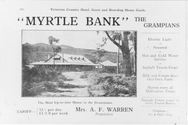
Photograph - B/W, C 1918
... Halls Gap & Grampians Historical Society Centennial Hall 117-119 Grampians Road Halls Gap grampians Information supplied with accommodation details Victorian Country Hotel, Guest and Boarding House Guide "Myrtle Bank" The Grampians Electric Light, Sewered, Hot and Cold Water Service, Asphalt, Tennis Court, Milk and Cream from our own farm, Motors meet all melbounre Trains, The Most Up-to-date house in the Grampians, Through Tickets issued by Govt. Tourist Bureau, Telephone : No. 1 Halls Gap Tariff: 12/ per day L 3/3/0 per week. Proprietress Mrs A. F Warren ACCOMMODATION Guesthouses Myrtlebank Quality ...Information supplied with accommodation details Victorian Country Hotel, Guest and Boarding House Guide "Myrtle Bank" The Grampians Electric Light, Sewered, Hot and Cold Water Service, Asphalt, Tennis Court, Milk and Cream from our own farm, Motors meet all melbounre Trains, The Most Up-to-date house in the Grampians, Through Tickets issued by Govt. Tourist Bureau, Telephone : No. 1 Halls Gap Tariff: 12/ per day L 3/3/0 per week. Proprietress Mrs A. F WarrenGuest House and grounds with Tariff information and servicesQuality paper made in Germanyaccommodation, guesthouses, myrtlebank -
 Eltham District Historical Society Inc
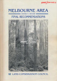
Book, Land Conservation Council, Melbourne Area, District 2 Review: Final Recommendations, 1994
... Timber resources and water quality and yield from timbered catchment areas remained significant issues in Melbourne’s catchments. ...Timber resources and water quality and yield from timbered catchment areas remained significant issues in Melbourne’s catchments. ...Notices showing the boundary of the area of the review and advising that an investigation was to be carried out were published in the Victoria Government Gazette and in local and other Victorian newspapers in May 1987. A descriptive resources report was published in August 1991. Council received 1,425 submissions and letters following publication of the descriptive report. The Council considered these submissions and published proposed recommendations in April 1993. A further 1,993 submissions were received in response to the proposed recommendations. The Council published its final recommendations in July 1994. A change to legislation in 1989 enabled the LCC to make recommendations for public land within a ‘town’, though cities and rural cities remained excluded from the definition of public land. Timber resources and water quality and yield from timbered catchment areas remained significant issues in Melbourne’s catchments. Recommendations for the Yarra Ranges National Park were based around the closed Melbourne water catchments and adjoining state forest. A recommended Phillip Island State Park based around the penguin reserve was ultimately implemented as the Phillip Island Nature Park.Shire of Nillumbik DPE/Enviro -
 Surrey Hills Historical Society Collection
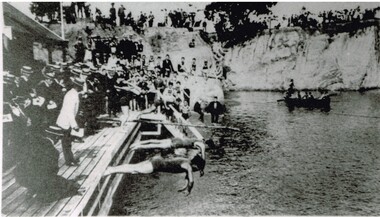
Photograph, Carnival Day at Surrey Dive, Possibly 1909
... These posed obvious safety issues, as did the water quality. Ivy Lavinia Weber, who was the second woman to be elected to the Victorian parliament (the first at a general election) and renowned for her commitment to health and physical fitness, campaigned for State government assistance to build new baths. ...These posed obvious safety issues, as did the water quality. Ivy Lavinia Weber, who was the second woman to be elected to the Victorian parliament (the first at a general election) and renowned for her commitment to health and physical fitness, campaigned for State government assistance to build new baths. ...This photo records one of the swimming carnivals held at the Surrey Dive, the first of which was organised in 1907. It was at the 1907 carnival that champion swimmer Frank Beaurepaire won the one-mile championship in record time. In the era before purpose-built municipal swimming pools, Surrey Dive was a popular destination for swimming and people came to it from many Melbourne suburbs. It operated from 1905 to 1967. It was the newly formed Surrey Park Swimming Club (established in 1905) that petitioned the Box Hill Council to purchase the former quarry site associated with the Box Hill Brick Works. A ramp, bathing sheds, springboards, and eventually a 10-lane course were developed, making the Dive the first Olympic standard pool in Australia. The carnivals attracted huge crowds. The original use as a quarry explains the notorious depth of the swimming hole and the sheer, steep cliffs surrounding it. These posed obvious safety issues, as did the water quality. Ivy Lavinia Weber, who was the second woman to be elected to the Victorian parliament (the first at a general election) and renowned for her commitment to health and physical fitness, campaigned for State government assistance to build new baths. These were built adjacent to the Dive and were opened in 1939. The Dive continued as a facility used by experienced swimmers until 1967 when it closed due to the drought causing the water to dry up. Today the site has been turned into an ornamental lake. This image was used as a mural in the refurbishment of the Box Hill Aqualink. The image has strong associations with early industry (brick making), recreation and particularly the early history of the sport of swimming.Black and white photo with a white border. Scan shows image only. It shows 3 men diving from a wooden platform into an area of water beneath higher banks. There is a boat in the background, a building to the LHS of the photo and many spectators in boater hats on the platform, some in bathing suits along a ledge and many around the top of the bank. Two men in the LH foreground may be officials.Printed long the bottom edge of the frame: "An image from history - Carnival Day at the Dive. / (photo: Box Hill Council)"surrey dive, box hill brick works, swimming, surrey park swimming club, (mr) frank beaurepaire, (mrs) ivy lavinia weber, swimming carnivals -
 Wodonga & District Historical Society Inc
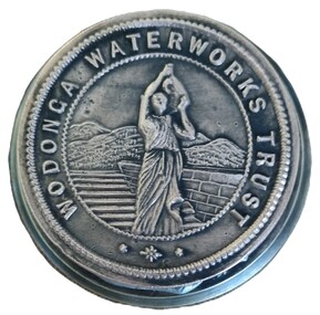
Functional object - Official Seal of the Wodonga Waterworks Trust
... water quality which had often been a problem. After lobbying the Victorian Department of Water Supply for several years, the first official meeting of the officially constituted Wodonga Waterworks Trust was held on Wednesday 20th October 1897. The Board initially consisted of all Wodonga Shire Councillors together with Mr Samuel Mason Jr., as the nominee of the Government. Councillor McFarlane was appointed as the first Chairman. This Seal was used to endorse all official documents issued...water quality which had often been a problem. After lobbying the Victorian Department of Water Supply for several years, the first official meeting of the officially constituted Wodonga Waterworks Trust was held on Wednesday 20th October 1897. The Board initially consisted of all Wodonga Shire Councillors together with Mr Samuel Mason Jr., as the nominee of the Government. Councillor McFarlane was appointed as the first Chairman. This Seal was used to endorse all official documents issued ...The Wodonga Waterworks Trust was established in 1897 to control and improve water supply to Wodonga. This included focus on the water quality which had often been a problem. After lobbying the Victorian Department of Water Supply for several years, the first official meeting of the officially constituted Wodonga Waterworks Trust was held on Wednesday 20th October 1897. The Board initially consisted of all Wodonga Shire Councillors together with Mr Samuel Mason Jr., as the nominee of the Government. Councillor McFarlane was appointed as the first Chairman. This Seal was used to endorse all official documents issued by the Trust. Documents placed between the two plates of the Seal would be embossed with the Trust’s emblem.This item is significant because it is representative of the first local government body constituted to improve water supply to Wodonga.A heavy metal seal machine used to make the imprint of the Wodonga Waterworks Trust. The seal is embossed on a circular disc. The imprint, which is not visible when assembled, shows an imprint of a woman in Grecian-style clothes carrying a water ewer on her shoulder.Around circular seal - WODONGA WATERWORKS TRUSTwodonga waterworks trust, water supply wodonga