Showing 414 items matching "water reserve"
-
 Bendigo Historical Society Inc.
Document - RAVENSWOOD - CROWN LAND - FORMER WATER RESERVE, 20 March 2012
... RAVENSWOOD - CROWN LAND - FORMER WATER RESERVE....Document, Ravenswood Crown Land, Former Water Reserve, Parish of Ravenswood, Comprises 3 old granite buildings related to the Ravenswood Run. ...Document RAVENSWOOD - CROWN LAND - FORMER WATER RESERVE. ...Document, Ravenswood Crown Land, Former Water Reserve, Parish of Ravenswood, Comprises 3 old granite buildings related to the Ravenswood Run. Old dam,and granite wall, potential archaeological values. Ironbark Forests & Woodlands investigation as natural features Reserve.DSR (Norn Stimson)document, ravenswood crown land -
 Stawell Historical Society Inc
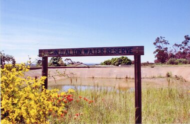
Photograph, John D'Alton water reserve sign on Big Hill
... John D'Alton water reserve sign on Big Hill...John D'Alton water reserve ...John D'Alton water reserve sign on Big Hill Photograph ...John D'Alton water reserve Colour photograph of wooden sign with reservoir in background and wattle on left.stawell -
 Stawell Historical Society Inc
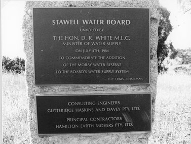
Photograph, "Moray" Water Reserve Plaque 1984
... "Moray" Water Reserve Plaque 1984...Plaque - Moray Water Reserve 1984...Stawell Historical Society Inc 46 Longfield St Stawell grampians Plaque - Moray Water Reserve 1984 Stawell "Moray" Water Reserve Plaque 1984 Photograph ...Plaque - Moray Water Reserve 1984stawell -
 Rutherglen Historical Society
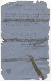
Document - Council permit, 1877 (Exact)
... ...water supply reserve...Letter granting permission to Mr Arthur Gribbin to shoot shag on the Water Supply Reserve. Mr Gribble was senior Constable of Police stationed at Rutherglen. ...Document written in black ink on blue paper, stamped with seal of Rutherglen Municipality, granting permission to Mr Arthur Gribbin to shoot shag on the Water Supply Reserve...Rutherglen Historical Society Murray Street Rutherglen high-country Letter granting permission to Mr Arthur Gribbin to shoot shag on the Water Supply Reserve. Mr Gribble was senior Constable of Police stationed at Rutherglen. ...Letter granting permission to Mr Arthur Gribbin to shoot shag on the Water Supply Reserve. Mr Gribble was senior Constable of Police stationed at Rutherglen. Water supply came from Lake King in the park. Councillors signing were Geo. Audley / Andrew Hunter (M. Gunter?) William Meehan. [check names - Gribbin - Gribble]Document written in black ink on blue paper, stamped with seal of Rutherglen Municipality, granting permission to Mr Arthur Gribbin to shoot shag on the Water Supply Reserve"Borough of Rutherglen / Town Hall / Rutherglen / 1st October 1877" Signed by Councillors and Town Clerk Thos. Reevespermit, water supply reserve, lake king, shag, rutherglen borough -
 Trentham and District Historical Society
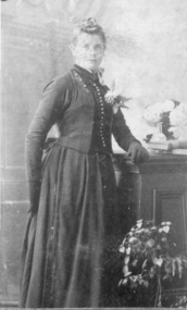
photograph, ? Caspar
... Caspar, the Caspar family lived on McMenamin's Lane and the Water reserve....Caspar, the Caspar family lived on McMenamin's Lane and the Water reserve. ? Caspar photograph ...? Caspar, the Caspar family lived on McMenamin's Lane and the Water reserve.people -
 The Beechworth Burke Museum
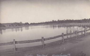
Photograph - Post Card, 1920-1930's
... ...water reserve...Lake Kerferd Beechworth water scheme water reserve reservoir Legislative Assembly Hon. ...Taken between 1920-1930s, shown is the banks of Lake Kerferd with wooden man-made fencing. The construction on Lake Kerferd began in 1862 however it wasn't completed until 1874 due to engineering and funding issues. The lake was named after George Briscoe Kerferd (1831–1889) who was responsible for Beechworth's water scheme. George Briscoe Kerferd was born on 21 January 1831 in Liverpool, England and arrived in Melbourne April 1853. He spent his first years in Australia in Bendigo before settling down in Beechworth as a wine and spirits merchant. He married Ann Martindale on 17th December 1853 at St James Cathedral, Melbourne and between them they had three sons and five daughters. Kerferd began his political and legal career in Beechworth when he was first elected to the Municipal Council in May 1857. Later he would be elected to the Legislative Assembly for the Ovens District in November 1864, and continued to represent the area until February 1886.The postcard holds Historic significance due to its connection to Beechworth and its Lake Kerford. It demonstrates the interactions between nature and colonialists, especially how the lake has somewhat been 'protected' with the man made fencing. It also presents information on the environmental development or degradation for the area, with possible changes to the environment that may have been caused by human physical forces, natural decay or Global Warming.Black and white rectangular postcard printed on paper.Obverse: Lake Kerferd, Beechworth / Reverse: 8164 / Post Card / Correspondence / Address Only / Kodak Austral [Kodak Australia Stamp] /lake kerferd, beechworth, water scheme, water reserve, reservoir, legislative assembly, hon. george briscoe kerferd, catchments, beechworth water reserve, beechworth catchments, municipal council, st. james cathedral, lakes, reserve, water supply, political projects, man-made fence, environmental changes -
 The Beechworth Burke Museum
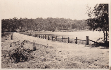
Photograph - Postcard, c1900
... ...water reserve...Lake Kerferd Beechworth water scheme water reserve reservoir Legislative Assembly Hon. ...The construction on Lake Kerferd began in 1862 however it wasn't completed until 1874 due to engineering and funding issues. The lake was named after George Briscoe Kerferd (1831–1889) who was responsible for Beechworth's water scheme. George Briscoe Kerferd was born on 21 January 1831 in Liverpool, England and arrived in Melbourne April 1853. He spent his first years in Australia in Bendigo before settling down in Beechworth as a wine and spirits merchant. He married Ann Martindale on 17th December 1853 at St James Cathedral, Melbourne and between them they had three sons and five daughters. Kerferd began his political and legal career in Beechworth when he was first elected to the Municipal Council in May 1857. Later he would be elected to the Legislative Assembly for the Ovens District in November 1864, and continued to represent the area until February 1886. This photograph is historically significant as it provides insight into the water reserves of Victoria. It also demonstrates the political identity of George Briscoe Kerferd and the Beechworth Municipal Council.Sepia rectangular postcard printed on paperObverse: Reverse: 83-131-1/ Post Card/ Correspondence / Address Only / BMM2997 / 53 / [Kodak Australia Stamp] lake kerferd, beechworth, water scheme, water reserve, reservoir, legislative assembly, hon. george briscoe kerferd, catchments, beechworth water reserve, beechworth catchments, municipal council, st. james cathedral, lakes, reserve, water supply, political projects -
 The Beechworth Burke Museum
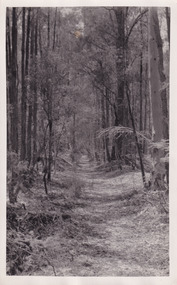
Photograph, Christmas 1941
... ...water reserve...This photograph is historically significant as it provides insight into surrounding areas of the water reserves of Victoria. It is also linked to political identity of George Briscoe Kerferd and the Beechworth Municipal Council. lake kerferd beechworth water scheme water reserve forest track forest pathway reservoir Legislative Assembly Hon. ...Taken on Christmas of 1941, shown is a track to Lake Kerferd with forest on both sides. The construction on Lake Kerferd began in 1862 however it wasn't completed until 1874 due to engineering and funding issues. The lake was named after George Briscoe Kerferd (1831–1889) who was responsible for Beechworth's water scheme. George Briscoe Kerferd was born on 21 January 1831 in Liverpool, England and arrived in Melbourne April 1853. He spent his first years in Australia in Bendigo before settling down in Beechworth as a wine and spirits merchant. He married Ann Martindale on 17th December 1853 at St James Cathedral, Melbourne and between them they had three sons and five daughters. Kerferd began his political and legal career in Beechworth when he was first elected to the Municipal Council in May 1857. Later he would be elected to the Legislative Assembly for the Ovens District in November 1864, and continued to represent the area until February 1886.This photograph is historically significant as it provides insight into surrounding areas of the water reserves of Victoria. It is also linked to political identity of George Briscoe Kerferd and the Beechworth Municipal Council.Black and white rectangular photograph printed on matte photographic paper.Obverse: Reverse: 8163/ Back track to Lake Kerford/ Beechworth/ Xmas 1941lake kerferd, beechworth, water scheme, water reserve, forest track, forest pathway, reservoir, legislative assembly, hon. george briscoe kerferd, catchments, beechworth water reserve, beechworth catchments, municipal council, st. james cathedral, lakes, reserve, water supply, political projects -
 The Beechworth Burke Museum
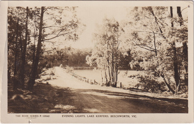
Photograph - Post Card, Rose Series Stereograph Co. Postcard
... ...water reserve...Lake Kerferd Beechworth water scheme water reserve reservoir Legislative Assembly Hon. ...The construction on Lake Kerferd began in 1862 however it wasn't completed until 1874 due to engineering and funding issues. The lake was named after George Briscoe Kerferd (1831–1889) who was responsible for Beechworth's water scheme. George Briscoe Kerferd was born on 21 January 1831 in Liverpool, England and arrived in Melbourne April 1853. He spent his first years in Australia in Bendigo before settling down in Beechworth as a wine and spirits merchant. He married Ann Martindale on 17th December 1853 at St James Cathedral, Melbourne and between them they had three sons and five daughters. Kerferd began his political and legal career in Beechworth when he was first elected to the Municipal Council in May 1857. Later he would be elected to the Legislative Assembly for the Ovens District in November 1864, and continued to represent the area until February 1886. The postcard holds Historic significance due to its connection to Beechworth and its Lake Kerford. It demonstrates the interactions between nature and colonialists, especially how the lake has somewhat been 'protected' with the man made fencing. It also presents information on the environmental development or degradation for the area, with possible changes to the environment that may have been caused by human physical forces, natural decay or Global Warming.Sepia rectangular postcard printed on paper.Obverse: The Rose Series P. 10542 / Copyright / Evening lights, Lake Kerferd, Beechworth, VIC Reverse: Farley / Published by the Rose Stereograph Co., / Armadale Victoria. / 84-132-1 / Post card / The "Rose" Series De Luxe / A Real Photograph Produced in Australia / BMM299 lake kerferd, beechworth, water scheme, water reserve, reservoir, legislative assembly, hon. george briscoe kerferd, catchments, beechworth water reserve, beechworth catchments, municipal council, st. james cathedral, lakes, reserve, water supply, political projects, rose series, postcard, rose series stereograph -
 The Beechworth Burke Museum
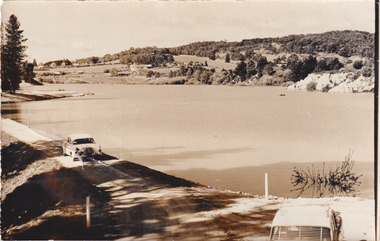
Photograph, 1960s
... ...water reserve...Beechworth water scheme water reserve catchments Beechworth water reserve beechworth catchments Municipal Council lakes reserve Water Supply political projects environmental changes Mr. ...Taken around 1960s, this photograph shows the banks of Lake Sambell. Lake Sambell is named after Mr. L. H. Sambell who was instrumental in the lake's formation. Lake Sambell is the original site of the open sluice operation of Rocky Mountain Mining Company in the 1800s and the early 1900s. In the early 1920s, it was reconstructed as a recreational lake and was formally opened to public on 6 October 1928. The opening event was attended by townspeople and Beechworth's Minister of Lands Mr. Bailey. In the late 1930s to early 1940s, Lake Sambell redeveloped. The first development aimed to raise the banks by six feet to double its present area and to make the water cleaner. Another redevelopment in the 1940s was made possible by the Beechworth and District Progress Association. It involved raising the banks to five feet to provide swimming facilities, paddling pool and caravan park. This photograph holds Historic significance because of its connection to the development of Beechworth district.Sepia rectangular photograph printed on matte photographic paperObverse: Reverse: 3533 /beechworth, water scheme, water reserve, catchments, beechworth water reserve, beechworth catchments, municipal council, lakes, reserve, water supply, political projects, environmental changes, mr. l. h. sambell, sambell, rocky mountain mining company, recreational lake, minister of lands, mr. bailey, swimming pool, paddling pool, caravan park, swimming facilities, lake redevelopment, funding -
 Bendigo Historical Society Inc.
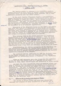
Document - PETER ELLIS COLLECTION: NOTES MENTIONING WHIPSTICK REGION
... Coliban/Sandhurst Water Supply Reserve...Four pages of typed notes mentioning the Whipstick Region, Mandurang Forest, Jackass Flat, Diamond Hill Area, One Tree Hill, and the Coliban/Sandhurst Water Supply Reserve. Mentioned are the Birds, Mammals, Geology, Flora, Ground Flora, Orchids,Lilies, Mistletoe, Ferns and Grasses of some of the areas....Reserves Peter Ellis Collection North/Central L.C.C. Region Bendigo Block Bendigo Field Naturalists Club Shipstick Scrub Mandurang Forest One Tree Hill Public park Redvers J Eddy Coliban/Sandhurst Water Supply Reserve Four pages of typed notes mentioning the Whipstick Region, Mandurang Forest, Jackass Flat, Diamond Hill Area, One Tree Hill, and the Coliban/Sandhurst Water Supply Reserve. ...Four pages of typed notes mentioning the Whipstick Region, Mandurang Forest, Jackass Flat, Diamond Hill Area, One Tree Hill, and the Coliban/Sandhurst Water Supply Reserve. Mentioned are the Birds, Mammals, Geology, Flora, Ground Flora, Orchids,Lilies, Mistletoe, Ferns and Grasses of some of the areas.bendigo, parks and gardens, public reserves, peter ellis collection, north/central l.c.c. region bendigo block, bendigo field naturalists club, shipstick scrub, mandurang forest, one tree hill public park, redvers j eddy, coliban/sandhurst water supply reserve -
 Stawell Historical Society Inc
Map, T.F. McGauran, William Couty of Borong 1891, 1891
... Stawell Water Supply Reserve. Grampians State Forest. Dairy Creek, Fyans Creek, Barney's Creek, Bovine Creek, Glasstree Creek, Stoney Creek. ...A2 Parish Map of Willam Inculdin Stawell Water Supply Reserve and Creeks. Marked in red...Stawell Historical Society Inc 46 Longfield St Stawell grampians Stawell Water Supply Reserve. Grampians State Forest. Dairy Creek, Fyans Creek, Barney's Creek, Bovine Creek, Glasstree Creek, Stoney Creek. ...Stawell Water Supply Reserve. Grampians State Forest. Dairy Creek, Fyans Creek, Barney's Creek, Bovine Creek, Glasstree Creek, Stoney Creek. Stawell Water Supply Aquaduct Fkuming Tunnel.A2 Parish Map of Willam Inculdin Stawell Water Supply Reserve and Creeks. Marked in redPhoto Lithographed at the Department of Lands and Survey Melbourne. By T.F. McGauran 20.07.91 water supply survey -
 Bendigo Historical Society Inc.
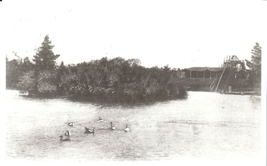
Photograph - UPPER RESERVE LAKE, early 1900's ?
... Water...upper reserve...black and white photo, lake with swans in foreground, island in centre, water slide in background. Water pondage upper reserve looking west, giant water slide in background, C 1908, taken from post card...Water pondage upper reserve looking west, giant water slide in background, C 1908, taken from post card. ( James Lerk 17.12.1999 ) Photograph UPPER RESERVE LAKE ...black and white photo, lake with swans in foreground, island in centre, water slide in background. Water pondage upper reserve looking west, giant water slide in background, C 1908, taken from post card. ( James Lerk 17.12.1999 )unknownplace, water, upper reserve, bendigo -
 Federation University Historical Collection
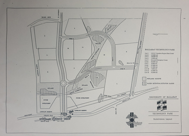
Plan - map, Ballarat Technology Park Wetlands Reserve and water retention basins, c1999
... Ballarat Technology Park Wetlands Reserve and water retention basins...It shows the Canadian Wetlands Researve and the water retentino.Detention Basins. Ballarat Technology Park Wetlands Reserve and water retention basins Plan map ...Yellow A4 page with a subdivision layout of the Ballarat Technology Park. It shows the Canadian Wetlands Researve and the water retentino.Detention Basins.canadian wetlands, ballarat technology park, mount helen campus -
 Lakes Entrance Historical Society
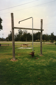
Photograph - Water Bore at Public Reserve Lakes Entrance, 1999
... Water Bore at Public Reserve Lakes Entrance...Colour photograph of the head works including feed pipe of water bore sunk in late 1958 on the Public Reserve bound by Marine Parade and the highway approach to North Arm Bridge, Lakes Entrance, Victoria....Photograph Water Bore at Public Reserve Lakes Entrance ...In late 1958 bore put down in an attempt to obtain good quality water for a reticulated town water supply. Water unsuitable, but during drought years when water supply from Nicholson River was restricted, water from this bore available for public use. Bore plugged, structure removed December 2000. Site marked with plaque March 2001, by Lakes Entrance Historical Society.Colour photograph of the head works including feed pipe of water bore sunk in late 1958 on the Public Reserve bound by Marine Parade and the highway approach to North Arm Bridge, Lakes Entrance, Victoria.water supply, public utilities -
 Federation University Historical Collection
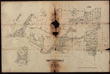
Plan, Smythesdale, County of Grenville, 01/12/1892
... A plan showing the Borough of Smythesdale, Smythesdale, Browns and Scarsdale, allotments, water reserve, Timber reserve, Nintingbool Pre-emptive Right, Reserve for public gardens, Reserve for Cricket Ground, Reserve for Reservoir...Gift of the Squire Family smythesdale scarsdale browns yarrowee carngham samuel barlett sheridan wrigley p. land r. simpson d. davis nintingbool mclachlan a. mclachlan c. taylor w. c. smith d. davies w. williams m. jones t. mcgurk r. selkirk a. mooney A plan showing the Borough of Smythesdale, Smythesdale, Browns and Scarsdale, allotments, water reserve, Timber reserve, Nintingbool Pre-emptive Right, Reserve for public gardens, Reserve for Cricket Ground, Reserve for Reservoir Smythesdale, County of Grenville Plan Department of Lands and Survey T.F. ...This plan is associated with former Ballarat School of Mines Student Richard Squire (1875-1876). Gift of the Squire FamilyA plan showing the Borough of Smythesdale, Smythesdale, Browns and Scarsdale, allotments, water reserve, Timber reserve, Nintingbool Pre-emptive Right, Reserve for public gardens, Reserve for Cricket Ground, Reserve for Reservoirsmythesdale, scarsdale, browns, yarrowee, carngham, samuel barlett, sheridan, wrigley, p. land, r. simpson, d. davis, nintingbool, mclachlan, a. mclachlan, c. taylor, w. c. smith, d. davies, w. williams, m. jones, t. mcgurk, r. selkirk, a. mooney -
Hand Tool Preservation Association of Australia Inc
Diagram
... Diagram reserve water supply...Hand Tool Preservation Association of Australia Inc No physical address melbourne This item is part of the Thomas Caine Tool Collection, owned by The National Trust of Australia (Victoria) and curated by the Hand Tools Preservation Association of Australia. Diagram reserve water supply Diagram ...This item is part of the Thomas Caine Tool Collection, owned by The National Trust of Australia (Victoria) and curated by the Hand Tools Preservation Association of Australia.Diagram reserve water supply -
Bendigo Historical Society Inc.
Map - CAMPBELL COLLECTION: BENDIGO AND DISTRICT MAPS
... Total area 5993 acres, Northern Railway to left of map, Water Reserve (Spring Gully). (number 363 in map cupboard 1)...Total area 5993 acres, Northern Railway to left of map, Water Reserve (Spring Gully). (number 363 in map cupboard 1) Map CAMPBELL COLLECTION: BENDIGO AND DISTRICT MAPS ...Map. Mandurang, Parish of Mandurang, Scale 20 chains to 1 inch. Total area 5993 acres, Northern Railway to left of map, Water Reserve (Spring Gully). (number 363 in map cupboard 1)map, bendigo, allotments -
 Bendigo Historical Society Inc.
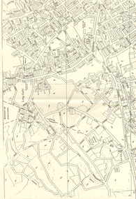
Map - LONG GULLY HISTORY GROUP COLLECTION: MAP OF LONG GULLY AREA
... Victorian Water Supply Reserve...History House 11 Mackenzie Street Bendigo goldfields BHS Collection BENDIGO History long gully history group The Long Gully History Group - Map of Long Gully Area Victorian Water Supply Reserve Borough of Eaglehawk Two copies of a map, printed on yellow paper, of the Long Gully Area. ...BHS CollectionTwo copies of a map, printed on yellow paper, of the Long Gully Area. It shows Eaglehawk Road from Barnard Street to a little past William Street.bendigo, history, long gully history group, the long gully history group - map of long gully area, victorian water supply reserve, borough of eaglehawk -
 Federation University Historical Collection
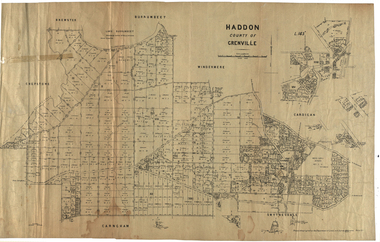
Plan, Haddon, County of Grenville, 1932, 13/04/1932
... ...water supply reserve...haddon grenville cardigan water supply reserve nentingbook pre-emptive right a. mclachlan lake burrumbeet e.a. wynne p. russell b. hepburn benjamin hepburn nentingbool t.c. wilson j. amoy william collard smith james roach j. mitchell The Haddon Parish Plan shows crown parcels government roads, Crown Reserves, Railway. ...The Haddon Parish Plan shows crown parcels government roads, Crown Reserves, Railway. Scale 40 chains to 1" (1:31, 680) WGS 84 Centroid Lat: 37 degrees 34' 00" S Long: 148 degrees 40' 20" E N.S. 9.3km E.W.: 16.1kmhaddon, grenville, cardigan, water supply reserve, nentingbook pre-emptive right, a. mclachlan, lake burrumbeet, e.a. wynne, p. russell, b. hepburn, benjamin hepburn, nentingbool, t.c. wilson, j. amoy, william collard smith, james roach, j. mitchell -
 Bendigo Historical Society Inc.
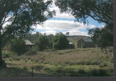
Photograph - RAVENSWOOD CROWN LANDS
... Photograph, Ravenswood Crown Lands ( water reserve ) 3 stone cottages on Crown land near Ravenswood shearing shed. ...History House 11 Mackenzie Street Bendigo goldfields PHOTOGRAPH Building ravenswood estate Photograph, Ravenswood Crown Lands ( water reserve ) 3 stone cottages on Crown land near Ravenswood shearing shed. ...Photograph, Ravenswood Crown Lands ( water reserve ) 3 stone cottages on Crown land near Ravenswood shearing shed. Cottages were used by the shearing teams. One contains a large wood stove and alongside, a bread oven (bricked over)photograph, building, ravenswood estate -
 Federation University Historical Collection
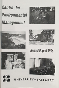
Booklet, University of Ballarat Centre for Environmental Management, 1996
... water assessment...conservation reserve management...The University will be working with the lessees to develop the historic Telegraph Station as a dual purpose facility for interpretation and research." university of ballarat centre for environmental management martin westbrooke richard mcewan mal weston john miller nanya telegraph station, cape otway cape otway lighthouse station cape otway telegraph station field resaerch stations s. hadden peter dahlhaus r.j. macewan pat prevett native vegetation assessment fauna management pest plants and animal research soil and water assessment conservation reserve management paul ryan richard macewan Black and white cover with clear plastic sheet. ...The Centre for Environmental Management as established in July 1995 as a strategic development initiative to consolidate the University's position as a centre for industry linked environmenttal teaching, resarech and consultancy. Page 19 "SPECIAL INITIATIVES Establishment of field Research Stations Two areas of concentration of research effort for the Centre are the Otways in the south western Victoria and the Scotia Country in the rangelands of NSW. In both these areas it is essential that ther be a secure accomodation abase for research students. In the former case there is a need for a sheltered base to enable year round field work in cold wet conditions and in the latter a base with a reliable water supply and the facilities to allow field work in very hot dry conditions which prevail from much of the year. It has been an ibjective of the Centre to establish field stations at these two sites and considerable progress has been made through the year. (i) Nanya Field Station in the Scotial Country Through the generosity of the owner, Mr Rob Taylor, an unused homestead on Nanya Station was made available to the Centre. Largely through voluntary labour during research field trips during the year this previously derelict homestead has been restored to functionality and now has facilities for up to 20 research workers with a reliable water supply, cooking, washing, and refrigeration facilities. (ii) Cape Otway Resaerch Centre Negotiations have continued through the year with the potential lessees of the Cape Otway Lighthouse Precinct with the support of the Vice Chancellor and other potential user groups within the University these have reached a successful outcome. The University will be working with the lessees to develop the historic Telegraph Station as a dual purpose facility for interpretation and research." Black and white cover with clear plastic sheet. university of ballarat, centre for environmental management, martin westbrooke, richard mcewan, mal weston, john miller, nanya, telegraph station, cape otway, cape otway lighthouse station, cape otway telegraph station, field resaerch stations, s. hadden, peter dahlhaus, r.j. macewan, pat prevett, native vegetation assessment, fauna management, pest plants and animal research, soil and water assessment, conservation reserve management, paul ryan, richard macewan -
 Ballarat Heritage Services
Photograph - Photograph - Colour, Looking Towards Locarno Spring and the Pavilion at Hepburn Springs Reserve, 2020, 22/04/2019
... water...Hepburn Springs Reserve...Ballarat Heritage Services PO Box 2209 Bakery Hill Post Office goldfields hepburn springs locarno mineral water Hepburn Springs Reserve Hepburn Springs Pavilion Locarmo spring Colour photograph of a view of the Hepburn Mineral Springs Reserve looking towards Locarno Spring and the Pavilion. ...Colour photograph of a view of the Hepburn Mineral Springs Reserve looking towards Locarno Spring and the Pavilion.hepburn springs, locarno, mineral water, hepburn springs reserve, hepburn springs pavilion, locarmo spring -
 Ballarat Heritage Services
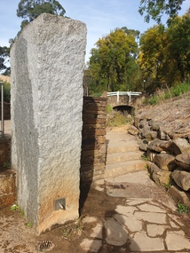
Photograph - Photograph - Colour, The Edna Walling Inspired Bridge at Locarno Spring in the Hepburn Springs Reserve, 2020, 12/12/2020
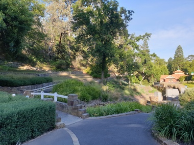
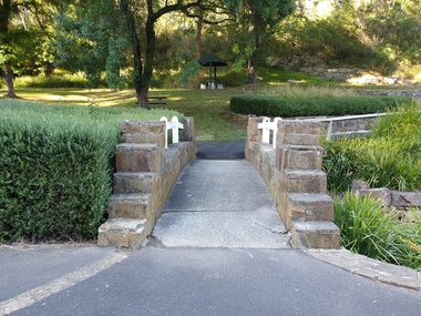
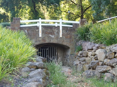
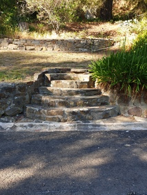
... water...Hepburn Springs Reserve...In 1934 there was a proposal to spend 2,000 to 3,000 poinds at the Hepburn Springs Reserve, with a govenrment loan suggested. hepburn springs locarno mineral water Hepburn Springs Reserve Locarno Spring Edna Walling Colour photograph of the stone bridge at Locarno Spring in the Hepburn Springs Reserve. ...The Hepburn Springs Progress Association invited Edna Walling the the Hepburn Springs Reserve, and sandstone paths and bridges resulted. In 1934 there was a proposal to spend 2,000 to 3,000 poinds at the Hepburn Springs Reserve, with a govenrment loan suggested. Colour photograph of the stone bridge at Locarno Spring in the Hepburn Springs Reserve.hepburn springs, locarno, mineral water, hepburn springs reserve, locarno spring, edna walling -
 Ballarat Heritage Services
Photograph - Photograph - Colour, The Edna Walling Bridge at Locarno Spring in the Hepburn Springs Reserve, 2020, 12/12/2020
... water...Hepburn Springs Reserve...In 1934 there was a proposal to spend 2,000 to 3,000 poinds at the Hepburn Springs Reserve, with a govenrment loan suggested. hepburn springs locarno mineral water Hepburn Springs Reserve Locarno Spring Edna Walling Colour photograph of the stone bridge at Locarno Spring in the Hepburn Springs Reserve, with the new 'placed' rocks in the surrounds c2000 The Edna Walling Bridge at Locarno Spring in the Hepburn Springs Reserve, 2020 Photograph Photograph - Colour Clare Gervasoni ...The Hepburn Springs Progress Association invited Edna Walling the the Hepburn Springs Reserve, and sandstone paths and bridges resulted. In 1934 there was a proposal to spend 2,000 to 3,000 poinds at the Hepburn Springs Reserve, with a govenrment loan suggested. Colour photograph of the stone bridge at Locarno Spring in the Hepburn Springs Reserve, with the new 'placed' rocks in the surrounds c2000hepburn springs, locarno, mineral water, hepburn springs reserve, locarno spring, edna walling -
 Ballarat Heritage Services
Photograph - Photograph - Colour, The Edna Walling inspired stonework at Locarno Spring in the Hepburn Springs Reserve, 2020, 12/12/2020
... water...Hepburn Springs Reserve...In 1934 there was a proposal to spend 2,000 to 3,000 pounds at the Hepburn Springs Reserve, with a govenrment loan suggested. hepburn springs mineral water Hepburn Springs Reserve Edna Walling Colour photograph of the stone bridge at Locarno Spring in the Hepburn Springs Reserve, with the new 'placed' rocks in the surrounds c2000 The Edna Walling inspired stonework at Locarno Spring in the Hepburn Springs Reserve, 2020 Photograph Photograph - Colour Clare Gervasoni ...The Hepburn Springs Progress Association invited Edna Walling the the Hepburn Springs Reserve, and sandstone paths and bridges resulted. In 1934 there was a proposal to spend 2,000 to 3,000 pounds at the Hepburn Springs Reserve, with a govenrment loan suggested. Colour photograph of the stone bridge at Locarno Spring in the Hepburn Springs Reserve, with the new 'placed' rocks in the surrounds c2000hepburn springs, mineral water, hepburn springs reserve, edna walling -
 Ballarat Heritage Services
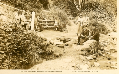
Photograph - Postcard, On the Hepburn Springs near Daylesford
... water...hepburn springs reserve...Ballarat Heritage Services PO Box 2209 Bakery Hill Post Office goldfields hepburn springs mineral water hepburn springs reserve Black and white postcard of Hard Hill Spring, Daylesford. ...Black and white postcard of Hard Hill Spring, Daylesford.hepburn springs, mineral water, hepburn springs reserve -
 Ballarat Heritage Services
Photograph - Photograph - Colour, Locarno Spring in the Hepburn Springs Reserve, 2019, 22/04/2019
... water...Hepburn Springs Reserve...Ballarat Heritage Services PO Box 2209 Bakery Hill Post Office goldfields hepburn springs locarno mineral water Hepburn Springs Reserve Colour photograph of the Locarno Spring at Hepburn Mineral Springs Reserve. ...Colour photograph of the Locarno Spring at Hepburn Mineral Springs Reserve.hepburn springs, locarno, mineral water, hepburn springs reserve -
 Ballarat Heritage Services
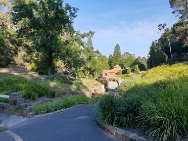
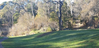
Photograph - Photograph - Colour, Hepburn Springs Reserve looking towards the Pavilion, 2025, 12/12/2020
... water...Hepburn Springs Reserve...In 1934 there was a proposal to spend 2,000 to 3,000 poinds at the Hepburn Springs Reserve, with a govenrment loan suggested. hepburn springs locarno mineral water Hepburn Springs Reserve Locarno Spring Edna Walling Hepburn Springs Pavilion Colour photograph of Hepburn Springs Reserve looking towards the Pavilion. ...The Hepburn Springs Progress Association invited Edna Walling the the Hepburn Springs Reserve, and sandstone paths and bridges resulted. In 1934 there was a proposal to spend 2,000 to 3,000 poinds at the Hepburn Springs Reserve, with a govenrment loan suggested. Colour photograph of Hepburn Springs Reserve looking towards the Pavilion. The stone work bridges and springs were inspired by Edna Walling. hepburn springs, locarno, mineral water, hepburn springs reserve, locarno spring, edna walling, hepburn springs pavilion