Showing 123 items matching "water skiing"
-
 Lake Bolac & District Historical Society
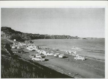
Black and white photograph, Water-skiing at Lake Bolac, 1950's
... Water-skiing at Lake Bolac, 1950's....lake bolac, water-skiing, 1950's, aquatic club...Water skiing began at Lake Bolac in the mid-50's. ...Only one boat launching ramp has been built at this time. lake bolac, water-skiing, 1950's, aquatic club Water-skiing at Lake Bolac, 1950's. ...Water skiing began at Lake Bolac in the mid-50's. This photo was taken in the 50's at the north beach before the construction of the Aquatic Club shed. Only one boat launching ramp has been built at this time.lake bolac, water-skiing, 1950's, aquatic club -
 Bendigo Historical Society Inc.
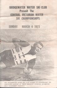
Pamphlet - Aileen and John Ellison Collection: Bridgewater water ski club
... Aileen and John Ellison Collection: Bridgewater water ski club......Water ski club...Established in 1960 on the Loddon River, the Bridgewater Water ski Club includes a general skiing area, a slalom course and a jumps course....Small pamphlet. Bridgewater water ski club present the Central Victorian water ski championships. ...Bridgewater Water ski club Small pamphlet. Bridgewater water ski club present the Central Victorian water ski championships. ...Established in 1960 on the Loddon River, the Bridgewater Water ski Club includes a general skiing area, a slalom course and a jumps course.Small pamphlet. Bridgewater water ski club present the Central Victorian water ski championships. Sunday March 4, 1973. on the front cover a male water skier and, on the back, a female one. The pamphlet lists the various categories and the names of the competitors. bridgewater, water ski club -
 The Beechworth Burke Museum
Photograph, 1960s
... ...Water skiing...Carter held the position of shire engineer from 1954-63 and organised many improvements to the Lake Sambell area including the caravan park in 1959, the lake swimming pool in 1961, water skiing and boating facilities, and increased the lake surface area in 1964. ...Carter held the position of shire engineer from 1954-63 and organised many improvements to the Lake Sambell area including the caravan park in 1959, the lake swimming pool in 1961, water skiing and boating facilities, and increased the lake surface area in 1964. ...This photograph was taken in the 1960s at Lake Sambell and is a view across the lake from the east side, the photo was taken during a period of improvements to the lake and surrounding area. Lake Sambell is an artificial lake that was created on the site of the old Rocky Mountain Mining Company workings and was officially opened by Minister for Lands, Mr Baily, on October 5, 1928. The disused and unattractive remains of the mine were converted into a recreational area intended for swimming, boating, and fishing. The lake is named after Mr L.H. Sambell, shire engineer and secretary of the Forward Beechworth Committee, who advocated for the enhancement of Beechworth into a tourist destination and was central to the planning and establishment of the lake. Funding for the project was raised through both competition funds and donations. Since the construction in 1928 several engineering issues have arisen. In 1939 the water levels were low, and the lake was considered both an eyesore and ‘mudhole’, Beechworth Shire Council sort funding to raise the height of the lake six feet to improve the quality of water. Throughout the 1940s the Beechworth Swimming Club sort to address the structural engineering issues and improve swimming facilities at the lake. R.E. Carter, similar to L.H. Sambell, was a shire engineer who advocated the importance of positioning Beechworth as a tourist destination. Carter held the position of shire engineer from 1954-63 and organised many improvements to the Lake Sambell area including the caravan park in 1959, the lake swimming pool in 1961, water skiing and boating facilities, and increased the lake surface area in 1964. These improvements to the lake also reflect an increase in leisure time and access to travel during a period of post-war prosperity in Australia during the 1950s and 60s. This photograph is of historical significance as it documents Lake Sambell in the 1960s after a series of enhancements to the lake area to improve its appearance and usability for both the people of Beechworth and tourists. It is also of social significance in providing an insight into the increase in leisure time and access to travel during a period of post-war prosperity. Black and white rectangle photograph printed on photographic paper and unmounted.Reverse: 3534 C798lake sambell, l.h. sambell, r.e. carter, rocky mountain mining company, forward beechworth committee, beechworth swimming club, wallace park lake sambell development scheme, lake sambell caravan park, beechworth 1960s, lake sambell swimming pool, lake sambell boating, lake sambell fishing, swimming, boating, water skiing, fishing, post-war prosperity, minister of lands, artificial lake, open cut sluice mine, lake -
 The Beechworth Burke Museum
Photograph, 1960s
... ...Water skiing...Carter held the position from 1954-63 and organised many improvements to the Lake Sambell area including the caravan park in 1959, the lake swimming pool in 1961, water skiing and boating facilities, and increased the lake surface are in 1964. ...Carter held the position from 1954-63 and organised many improvements to the Lake Sambell area including the caravan park in 1959, the lake swimming pool in 1961, water skiing and boating facilities, and increased the lake surface are in 1964. ...This photo was taken in the 1960s from a northeast position looking down towards Lake Sambell, the caravan park, and the surrounding area. This photo was taken during a period of rejuvenation for the lake area including the opening of the caravan park in 1959 and the swimming pool area in 1961 (this pool is just visible in the centre of the photo). The popularity of caravanning in Australia exploded during this post-war period of the late 1950s and 1960’s. This popularity was driven by multiple factors, including: the stopping of fuel rations, the accessibility of car ownership through the manufacturing of affordable cars, technological developments in caravan design, and the increase in prosperity and leisure time for many Australians. Lake Sambell is an artificial lake that was developed on the previous site of the Rocky Mountain Mining Company workings and was officially opened by Minister for Lands, Mr Baily, on October 5, 1928. The disused and unattractive remains of the mine were converted into a recreational area intended for swimming, boating, and fishing. The lake is named after Mr L.H. Sambell, shire engineer and secretary of the Forward Beechworth Committee, who advocated for the enhancement of Beechworth into a tourist destination and was central to the planning and establishment of the lake. Funding for the project was raised by both competition funds and donations. Since the construction in 1928 several engineering issues have arisen. In 1939 the water levels were low, and the lake was considered both an eyesore and ‘mudhole’, Beechworth Shire Council sort funding to raise the height of the lake six feet to improve the quality of water. Throughout the 1940s the Beechworth Swimming Club tried to raise awareness and funds to address the structural engineering issues and improve swimming facilities at the lake. R.E. Carter, similar to L.H. Sambell, was a shire engineer who advocated the importance of positioning Beechworth as a tourist destination. Carter held the position from 1954-63 and organised many improvements to the Lake Sambell area including the caravan park in 1959, the lake swimming pool in 1961, water skiing and boating facilities, and increased the lake surface are in 1964. These improvements were financed mainly by grants from the Tourist Development Authority. This photograph is of historical significance as it documents Lake Sambell and the surrounding area in the 1960s after a phase of enhancements to improve the appearance and usability for both the people of Beechworth and tourists. It is also of social significance in providing an insight into the increase in leisure time and access to travel during a period of post-war prosperity.Black and white rectangle photograph printed on matte photographic paper and unmounted.Reverse: 1 / [logo KODAK/ VELOX/ PAPER] / C798 / 3535lake sambell, lake sambell caravan park, lake sambell swimming pool, caravan park, caravanning 1960s, rocky mountain mining company, l.h. sambell, r.e. carter, beechworth swimming club, forward beechworth committee, minister of lands, tourist development authority, lake swimming, swimming, boating, fishing, water skiing, beechworth 1960s, lake sambell fishing, lake sambell boating -
 Glenelg Shire Council Cultural Collection
Souvenir - Sticker, n.d
... White with black line figure water skiing, bridge in background. "NELSON' large red letters....White with black line figure water skiing, bridge in background. "NELSON' large red letters. ...Oval vinyl souvenir sticker, self adhesive, Nelson Vic. White with black line figure water skiing, bridge in background. "NELSON' large red letters. -
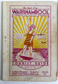 Warrnambool and District Historical Society Inc.
Booklet - Warrnambool Tourist Guide, Warrnambool Progress Association, Warrnambool On The Sea Tourist Guide, The Ideal City, Where to Go and What to See, 1936
... This is a booklet with a buff-coloured cover featuring an illustration of a woman water skiing. The back cover has blue printing. ...Tourism in Warrnambool Warrnambool Progress Association Warrnambool Tourist Guide 1936 This is a booklet with a buff-coloured cover featuring an illustration of a woman water skiing. The back cover has blue printing. ...Warrnambool Tourist Guide 1936This is a booklet with a buff-coloured cover featuring an illustration of a woman water skiing. The back cover has blue printing. The pages contain a fold-out map, advertisements, printed text and black and white photographs. The pages have been stapled and then glued.non-fictionWarrnambool Tourist Guide 1936tourism in warrnambool, warrnambool progress association -
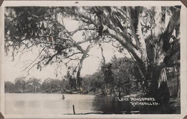 Rutherglen Historical Society
Photograph - Image, 1914-1920 (Approximate)
... Lake Moodemere has always been a beauty spot & picnic area for the locals, today many speedboats use it for water skiing, it is a wildlife sanctuary...Rutherglen Historical Society Murray Street Rutherglen high-country Lake Moodemere has always been a beauty spot & picnic area for the locals, today many speedboats use it for water skiing, it is a wildlife sanctuary "Lake Moodemere Rutherglen" Black & white photograph, unframed but pasted to pages of an album. ...Lake Moodemere has always been a beauty spot & picnic area for the locals, today many speedboats use it for water skiing, it is a wildlife sanctuaryBlack & white photograph, unframed but pasted to pages of an album. Lake Moodemere, Rutherglen"Lake Moodemere Rutherglen" -
Vision Australia
Audio (item) - Sound recording, Royal Victorian Institute for the Blind, Around the Institute: July 22, 2003
... July 22: NILS and the move to Kooyong – Jamie Kelly, Water skiing – Jason Hanrahan....July 22: NILS and the move to Kooyong – Jamie Kelly, Water skiing – Jason Hanrahan. Royal Victorian Institute for the Blind Radio shows 1 digital sound file in WAV format Around the Institute: July 22, 2003 Audio Sound recording Royal Victorian Institute for the Blind Corey Nassau ...Around the Institute was a weekly program consisting of interviews around a specific topic, undertaken by host Corey Nassau. July 22: NILS and the move to Kooyong – Jamie Kelly, Water skiing – Jason Hanrahan.royal victorian institute for the blind, radio shows -
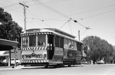 Ballarat Tramway Museum
Photograph - Ballarat Tram 12 at Mt Pleasant terminus, Robert Wilson, 11-11-1967
... The tram has a dash panel advert for the Twin Lakes, a long closed water ski resort near Ballan....The tram has a dash panel advert for the Twin Lakes, a long closed water ski resort near Ballan. Yields information about the Mt Pleasant terminus in late 1967. ...Image of Ballarat tram 12 at the Mt Pleasant terminus before returning to the Gardens via Drummond St North. The tram has a dash panel advert for the Twin Lakes, a long closed water ski resort near Ballan.Yields information about the Mt Pleasant terminus in late 1967.Digital image of Ballarat Tram 12 at Mt Pleasant terminus 11-11-1967.trams, tramways, mt pleasant, ballarat tramways, tram 12, twin lakes -
Vision Australia
Audio (item) - Sound recording, Royal Victorian Institute for the Blind, Around the Institute: March 9, 2004
... March 9: RVIB history group project – Michelle Prentice, Water Skiing Come and Try day – Kevin Murfitt. ...March 9: RVIB history group project – Michelle Prentice, Water Skiing Come and Try day – Kevin Murfitt. ...Around the Institute was a weekly program consisting of interviews around a specific topic, undertaken by host Corey Nassau. March 9: RVIB history group project – Michelle Prentice, Water Skiing Come and Try day – Kevin Murfitt. royal victorian institute for the blind, radio shows -
Vision Australia
Audio (item) - Sound recording, Royal Victorian Institute for the Blind, Around the Institute: February 13, 2001
... It consisted of interviews undertaken by Jo Matthews, with sound engineer Ed Gamble, designed to inform, educate and explore on a variety of topics. February 13: Water ski camp – Rae Christensen, Client reference groups – Katie Andrews....It consisted of interviews undertaken by Jo Matthews, with sound engineer Ed Gamble, designed to inform, educate and explore on a variety of topics. February 13: Water ski camp – Rae Christensen, Client reference groups – Katie Andrews. ...Around the Institute was a weekly program designed to keep clients and staff informed of events, activities and thoughts relating to low vision and blindness. It consisted of interviews undertaken by Jo Matthews, with sound engineer Ed Gamble, designed to inform, educate and explore on a variety of topics. February 13: Water ski camp – Rae Christensen, Client reference groups – Katie Andrews.royal victorian institute for the blind, radio shows -
Vision Australia
Audio (item) - Sound recording, Royal Victorian Institute for the Blind, Around the Institute: February 15, 2000
... February 15: Melbourne Glaucoma Australia support group - Maureen Boyle, Water skiing – Kevin Murfitt...February 15: Melbourne Glaucoma Australia support group - Maureen Boyle, Water skiing – Kevin Murfitt Royal Victorian Institute for the Blind Radio shows 1 digital sound file in WAV format Around the Institute: February 15, 2000 Audio Sound recording Royal Victorian Institute for the Blind ...Around the Institute was a weekly program designed to keep clients and staff informed of events, activities and thoughts relating to low vision and blindness. It consisted of interviews undertaken by Jo Matthews, with sound engineer Ed Gamble, designed to inform, educate and explore on a variety of topics. February 15: Melbourne Glaucoma Australia support group - Maureen Boyle, Water skiing – Kevin Murfittroyal victorian institute for the blind, radio shows -
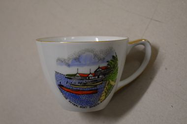 Warrnambool and District Historical Society Inc.
Cuo, Westminster China Australia, Hopkins River Boat, Mid 20th century
... The Hopkins River is a popular recreation destination with boating, fishing and water skiing. The Proudfoots Boathouse was established in 1885 by Thomas Proudfoot. ...The Hopkins River is a popular recreation destination with boating, fishing and water skiing. The Proudfoots Boathouse was established in 1885 by Thomas Proudfoot. ...Tourism has been an important industry in Warrnambool for over 100 years. In the late 19th century Warrnambool was promoted as a spa resort offering a mild climate, seaside swimming and hot and cold seawater baths. Today tourists come in winter to see the Southern Right whales at Logans Beach and in summer they come for a beach holiday. The Hopkins River is a popular recreation destination with boating, fishing and water skiing. The Proudfoots Boathouse was established in 1885 by Thomas Proudfoot. This cup is an interesting example of a Warrnambool tourist souvenir from the mid to late 20th century.This is a small white china cup. There is gold edging around the rim and on the handle. On the side of the cup is a coloured image of Proudfoots Boatsheds at the mouth of the Hopkins River in Warrnambool. Hopkins River Boatsheds Warrnambool Fine China Westminster China Australia tourism in warrnambool, history of warrnambool -
Vision Australia
Audio (item) - Sound recording, Royal Victorian Institute for the Blind, Around the Institute: March 5, 2002
... March 5: Audio described videos - Marcus Stacey and Kelly Caulfield, Timor project – Janet Cronin, Water skiing, canoeing and other recreation programs – Chris Headland....March 5: Audio described videos - Marcus Stacey and Kelly Caulfield, Timor project – Janet Cronin, Water skiing, canoeing and other recreation programs – Chris Headland. ...Around the Institute was a weekly program designed to keep clients and staff informed of events, activities and thoughts relating to low vision and blindness. It consisted of interviews undertaken by Jo Matthews-Lamb, Susan Thompson, Janet Cronin and Corey Nassau, with sound engineer Ed Gamble, designed to inform, educate and explore on a variety of topics. March 5: Audio described videos - Marcus Stacey and Kelly Caulfield, Timor project – Janet Cronin, Water skiing, canoeing and other recreation programs – Chris Headland.royal victorian institute for the blind, radio shows -
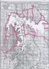
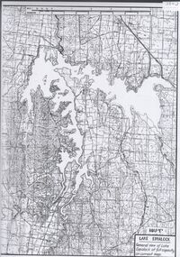 Bendigo Historical Society Inc.
Map - Laminated map of Lake Eppalock at full capacity. Map 'E'
... Permissible activities on the lake include high-speed boating, water skiing, sailing, canoeing, fishing and swimming. ...Permissible activities on the lake include high-speed boating, water skiing, sailing, canoeing, fishing and swimming. ...John Perry Collection. Laminated map of Lake Eppalock at full capacity. Black and white. The dam was built by the State Rivers and Water Supply Commission of Victoria. The dam wall height is 45 metres (148 ft) and the main embankment is 1,041 metres (3,415 ft) long. At 100% capacity the dam wall was designed to hold back 304,651 megalitres (6.7014×10¹⁰ imp gal; 8.0480×10¹⁰ US gal) of water. The surface area of Lake Eppalock is 3,011 hectares (7,440 acres) and the catchment area is 2,124 square kilometres (820 sq mi). The controlled spillway is capable of discharging 8,040 cubic metres per second (284,000 cu ft/s). Lake Eppalock supplies both stock and domestic water to the Campaspe irrigation district. It also serves as a water supply to Bendigo and Heathcote and, in more recent times, Ballarat. The lake is a major attraction for those engaging in watersports, with a number of tourist parks and accommodation facilities available. Permissible activities on the lake include high-speed boating, water skiing, sailing, canoeing, fishing and swimming. The lake's water levels were low for approximately eight years between 2002 and 2010 during a prolonged drought, which restricted the amount of recreational activity until rainfall in the latter half of 2010 returned the lake to 100 percent capacity. Built between 1961 and 1964, Lake Eppalock remains the only water storage on the Campaspe River system.map, eppalock, water, dam, reservoir -
 The Beechworth Burke Museum
Photograph, 1960s
... The opening of the caravan park was part of many improvements to Lake Sambell made in this period by Carter including: the swimming pool in 1961, water skiing and boating facilities, and increased lake surface in 1964. ...The opening of the caravan park was part of many improvements to Lake Sambell made in this period by Carter including: the swimming pool in 1961, water skiing and boating facilities, and increased lake surface in 1964. ...This photograph was taken in the 1960s at Lake Sambell Caravan Park and visible in the photograph are individual caravan sites with electricity outlets, a large single-story building with a caravan park banner, dirt roads, a freestanding message board, and a parked car. Lake Sambell Caravan Park opened in 1959 owing to the work of R.E. Carter, Beechworth Shire engineer from 1954-63. Carter advocated for improvements to the lake and surrounding area in order to encourage tourism in Beechworth. The opening of the caravan park was part of many improvements to Lake Sambell made in this period by Carter including: the swimming pool in 1961, water skiing and boating facilities, and increased lake surface in 1964. These improvements were financed mainly by grants from the Tourist Development Authority. The popularity of caravanning in Australia exploded during this post-war period of the late 1950s and 1960s. This popularity was driven by multiple factors, including: the stopping of fuel rations, the accessibility of car ownership through the manufacturing of affordable cars, technological developments in caravan design, and the increase in prosperity and leisure time for many Australians. Facilities such as electrical outlets to power caravans are present in this photograph of Lake Sambell Caravan Park. Lake Sambell is an artificial lake that was developed on the previous site of the Rocky Mountain Mining Company workings and was officially opened by Minister for Lands, Mr Baily, on October 5, 1928. The disused and unattractive remains of the mine were converted into a recreational area intended for swimming, boating, and fishing. The lake is named after Mr L.H. Sambell, shire engineer and secretary of the Forward Beechworth Committee, who advocated for the enhancement of Beechworth into a tourist destination and was central to the planning and establishment of the lake. This photograph is of historical and social significance in providing insight into caravanning during the 1960s in Australia. Caravanning was extremely popular during the 1960s in Australia due to multiple social and economic factors including the stopping of fuel rations, the accessibility of car ownership through the manufacturing of affordable cars, technological developments in caravan design, and the increase in prosperity and leisure time for many Australians.Black and white rectangle photograph printed on photographic paper and unmounted.Reverse: 3536/ [logo back printing: KODAK/ VELOX/ PAPER] / C798 lake sambell caravan park, lake sambell, caravanning 1960s, caravan park, rocky mountain mining company, kodak velox paper, r.e. carter, l.h. sambell, caravan electricity outlets, tourist development authority, post-war prosperity, forward beechworth committee, lake sambell boating, lake sambell swimming pool, lake sambell fishing, artificial lake, travel 1960s, recreation 1960s -
 The Beechworth Burke Museum
Photograph, 1960s
... The opening of the swimming pool was part of many improvements to Lake Sambell made during this period by Carter including establishing the caravan park in 1959, water skiing and boating facilities, and increasing the lake surface in 1964. ...The opening of the swimming pool was part of many improvements to Lake Sambell made during this period by Carter including establishing the caravan park in 1959, water skiing and boating facilities, and increasing the lake surface in 1964. ...This photograph was taken in the 1960s of the Lake Sambell Swimming Pool with the lake itself in the background. The swimming pool area has multiple features including park benches, a water slide, and a fenced area with a diving pontoon for lap swimming and racing. Lake Sambell Swimming Pool was completed in 1961, driven largely by R.E. Carter, Beechworth shire engineer from 1954-63. Carter advocated for improvements to the lake and surrounding area in order to encourage tourism in Beechworth. The opening of the swimming pool was part of many improvements to Lake Sambell made during this period by Carter including establishing the caravan park in 1959, water skiing and boating facilities, and increasing the lake surface in 1964. These improvements were financed mainly by grants from the Tourist Development Authority. For many decades, members of the local Beechworth community had advocated for the development of swimming pool at the lake that would include a safe wadding area and Olympic standard lanes for laps and races. Throughout the 1940s the Beechworth Swimming Club tried to raise awareness and funds to address the structural engineering issues, raise the water levels, and improve swimming facilities at the lake. Beechworth Swimming Club hosted a swimming carnival at the lake in 1948, but it was decided due to several issues at the event, that no further carnivals would be hosted until necessary improvements were made to the area. Swimming pools, both artificial and built into natural environments, were an extremely popular public space throughout the 20th century in Australia. Increasing in accessibility and popularity through such developments as less restrictive swimming outfits during 1920s, public building works during the 1920s and 30s, and an increase in leisure time during a period of post-war prosperity. This photograph is of historical significance as it documents the newly established Lake Sambell Swimming Pool in the 1960s after many decades of discussion and proposals around creating a safe swimming area at the lake. Further, this photograph provides important social insights into the facilities and uses of this pool in the 1960s, and underlines the significant role public swimming pools have played in Australian social and recreational experiences. Black and white rectangle photograph printed on photographic paper and unmounted.Reverse: 3537 / C798lake sambell swimming pool, lake sambell water slide, water slide 1960s, lake sambell pontoon, lake sambell 1960s, lake swimming pool, lake swimming, beechworth swimming club, swimming pools in the 20th century, r.e. carter, tourist development authority, beechworth 1960s, lake water slide, lake sambell, wadding pool, swimming, swimming pool 1960s, leisure, recreation 1960s -
 The Beechworth Burke Museum
Photograph, 1960s
... The opening of the caravan park was part of many improvements to Lake Sambell made in this period by Carter including: the swimming pool in 1961, water skiing and boating facilities, and increased lake surface in 1964. ...The opening of the caravan park was part of many improvements to Lake Sambell made in this period by Carter including: the swimming pool in 1961, water skiing and boating facilities, and increased lake surface in 1964. ...This photograph was taken in the 1960s at Lake Sambell Caravan Park, visible in the photograph are individual caravan sites with electricity outlets, a large single-story building, a parked car, and two caravans partially obstructed by trees. Lake Sambell Caravan Park opened in 1959 owing to the work of R.E. Carter, Beechworth Shire engineer from 1954-63. Carter advocated for improvements to the lake and surrounding area in order to encourage tourism in Beechworth. The opening of the caravan park was part of many improvements to Lake Sambell made in this period by Carter including: the swimming pool in 1961, water skiing and boating facilities, and increased lake surface in 1964. These improvements were financed mainly by grants from the Tourist Development Authority. The popularity of caravanning in Australia exploded during this post-war period of the late 1950s and 1960s. This popularity was driven by multiple factors, including: the stopping of fuel rations, the accessibility of car ownership through the manufacturing of affordable cars, technological developments in caravan design, and the increase in prosperity and leisure time for many Australians. Facilities such as electrical outlets to power caravans are present in this photograph of Lake Sambell Caravan Park. Lake Sambell is an artificial lake that was developed on the previous site of the Rocky Mountain Mining Company workings and was officially opened by Minister for Lands, Mr Baily, on October 5, 1928. The disused and unattractive remains of the mine were converted into a recreational area intended for swimming, boating, and fishing. The lake is named after Mr L.H. Sambell, shire engineer and secretary of the Forward Beechworth Committee, who advocated for the enhancement of Beechworth into a tourist destination and was central to the planning and establishment of the lake. This photograph is of historic and social significance in documenting the enhancement of the Lake Sambell area overseen by R.E. Carter and providing insight into caravanning during the 1960s in Australia. Caravanning was extremely popular in Australia during the late 1950s and 60s due to multiple social and economic factors including the stopping of fuel rations, the accessibility of car ownership through the manufacturing of affordable cars, technological developments in caravan design, and the increase in prosperity and leisure time for many Australians. Black and white rectangle photograph printed on photographic paper and unmounted.Reverse: 3538/ [logo back printing KODAK/ VELOX/ PAPER] / C798lake sambell caravan park, lake sambell, lake sambell 1960s, lake sambell fishing, lake sambell boating, lake sambell swimming pool, r.e. carter, l.h. sambell, tourist development authority, caravanning 1960s, caravan electricity outlets, caravan park, forward beechworth committee, rocky mountain mining company, lake caravan park, caravan mid 20th century, beechworth tourism, travel in the 1960s, holiday 1960s -
 Stawell Historical Society Inc
Photograph, Stawell People in Horsham Paper Wimmera Advertiser
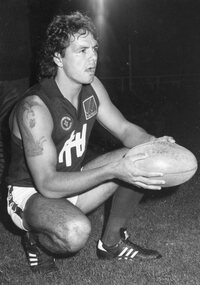
... Aug 1986 -7 Tony Spencer, Bradley Spencer, John Burges, Darren Spencer, Water Skiing trophies, July 1992 -8 Robert Scott, Golf, March 1986 -9 Brian Jenkins, Glider Tug Pilot, Feb 1981 -10 Kevin McDonald, Ken Easson, Boating, Jan 1992 -11 Tony Norton, Hot Air Ballooning, June 1987 -12 Tony Norton, Hot Air Ballooning, June 1987 -13 Mandy Lowndes, Cornet Player 13yrs, Oct 1989 -14 Mandy Lowndes, Cornet Player 13yrs, Oct 1989 -15 Peter Gibbon, Sailing Arrow Cat Parkdale Yacht Club, Mar 1991 -16 Bill Gilchrist at Central Park, July 1989 -17 Keith Eales, Graham Eales, Stan Edwards, Stawell Rifle Club, Sept 1985 -18 Terry O’Sullivan, Stawell New Year Races, Jan 1989 -19 Chris Start, Stawell Gift, April 1987 -20 Casper Cosson, Stawell, April 1995 -21 Stawell Gift Central Park Gates, Jan 1989 -22 Stawell Gift, April 1987 ...Aug 1986 -7 Tony Spencer, Bradley Spencer, John Burges, Darren Spencer, Water Skiing trophies, July 1992 -8 Robert Scott, Golf, March 1986 -9 Brian Jenkins, Glider Tug Pilot, Feb 1981 -10 Kevin McDonald, Ken Easson, Boating, Jan 1992 -11 Tony Norton, Hot Air Ballooning, June 1987 -12 Tony Norton, Hot Air Ballooning, June 1987 -13 Mandy Lowndes, Cornet Player 13yrs, Oct 1989 -14 Mandy Lowndes, Cornet Player 13yrs, Oct 1989 -15 Peter Gibbon, Sailing Arrow Cat Parkdale Yacht Club, Mar 1991 -16 Bill Gilchrist at Central Park, July 1989 -17 Keith Eales, Graham Eales, Stan Edwards, Stawell Rifle Club, Sept 1985 -18 Terry O’Sullivan, Stawell New Year Races, Jan 1989 -19 Chris Start, Stawell Gift, April 1987 -20 Casper Cosson, Stawell, April 1995 -21 Stawell Gift Central Park Gates, Jan 1989 -22 Stawell Gift, April 1987 B/W Photographs Stawell People in Horsham Paper Wimmera Advertiser Photograph ...7253 Tim Chatfield, Stawell. May 1991 -1 Murray Emerson, Stawell Football Club Coach, Aug 1991 -2 Shaun Allan, Stawell Football, July 1990 -3 David “Soup” Moloney, Stawell Football, July 1990 -4 Darren Austen, Football Ararat vs Stawell, Sept 1986 -5 Jason Gordon, Stephen Partington, Football Ararat vs Stawell. Aug 1986 -6 Gary Russell, Noel O’Brien, Football Ararat vs Stawell. Aug 1986 -7 Tony Spencer, Bradley Spencer, John Burges, Darren Spencer, Water Skiing trophies, July 1992 -8 Robert Scott, Golf, March 1986 -9 Brian Jenkins, Glider Tug Pilot, Feb 1981 -10 Kevin McDonald, Ken Easson, Boating, Jan 1992 -11 Tony Norton, Hot Air Ballooning, June 1987 -12 Tony Norton, Hot Air Ballooning, June 1987 -13 Mandy Lowndes, Cornet Player 13yrs, Oct 1989 -14 Mandy Lowndes, Cornet Player 13yrs, Oct 1989 -15 Peter Gibbon, Sailing Arrow Cat Parkdale Yacht Club, Mar 1991 -16 Bill Gilchrist at Central Park, July 1989 -17 Keith Eales, Graham Eales, Stan Edwards, Stawell Rifle Club, Sept 1985 -18 Terry O’Sullivan, Stawell New Year Races, Jan 1989 -19 Chris Start, Stawell Gift, April 1987 -20 Casper Cosson, Stawell, April 1995 -21 Stawell Gift Central Park Gates, Jan 1989 -22 Stawell Gift, April 1987 B/W Photographs -
 Bendigo Historical Society Inc.
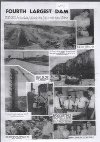
Document - Collection of photographs from newspaper on a single page
... Permissible activities on the lake include high-speed boating, water skiing, sailing, canoeing, fishing and swimming. ...Permissible activities on the lake include high-speed boating, water skiing, sailing, canoeing, fishing and swimming. ...John Perry Collection. Laminated copy of page from 'Weekly Times' newspaper, February, 1962. Nine images relating to establishing and building Eppalock Reservoir, 15 miles from Bendigo. The dam was built by the State Rivers and Water Supply Commission of Victoria. The dam wall height is 45 metres (148 ft) and the main embankment is 1,041 metres (3,415 ft) long. At 100% capacity the dam wall was designed to hold back 304,651 megalitres (6.7014×10¹⁰ imp gal; 8.0480×10¹⁰ US gal) of water. The surface area of Lake Eppalock is 3,011 hectares (7,440 acres) and the catchment area is 2,124 square kilometres (820 sq mi). The controlled spillway is capable of discharging 8,040 cubic metres per second (284,000 cu ft/s). Lake Eppalock supplies both stock and domestic water to the Campaspe irrigation district. It also serves as a water supply to Bendigo and Heathcote and, in more recent times, Ballarat. The lake is a major attraction for those engaging in watersports, with a number of tourist parks and accommodation facilities available. Permissible activities on the lake include high-speed boating, water skiing, sailing, canoeing, fishing and swimming. The lake's water levels were low for approximately eight years between 2002 and 2010 during a prolonged drought, which restricted the amount of recreational activity until rainfall in the latter half of 2010 returned the lake to 100 percent capacity. Built between 1961 and 1964, Lake Eppalock remains the only water storage on the Campaspe River system. dam, engineering, water, eppalock -
 Bendigo Historical Society Inc.
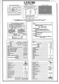
Document - Legend to maps A, B and C for Lake Eppalock
... Permissible activities on the lake include high-speed boating, water skiing, sailing, canoeing, fishing and swimming. ...Permissible activities on the lake include high-speed boating, water skiing, sailing, canoeing, fishing and swimming. ...John Perry Collection. Laminated 'legend' for Maps A, B and C for Lake Eppalock also in this collection. Black and White definitions and descriptions of objects and markers found on maps. Circa 1951. The dam was built by the State Rivers and Water Supply Commission of Victoria. The dam wall height is 45 metres (148 ft) and the main embankment is 1,041 metres (3,415 ft) long. At 100% capacity the dam wall was designed to hold back 304,651 megalitres (6.7014×10¹⁰ imp gal; 8.0480×10¹⁰ US gal) of water. The surface area of Lake Eppalock is 3,011 hectares (7,440 acres) and the catchment area is 2,124 square kilometres (820 sq mi). The controlled spillway is capable of discharging 8,040 cubic metres per second (284,000 cu ft/s). Lake Eppalock supplies both stock and domestic water to the Campaspe irrigation district. It also serves as a water supply to Bendigo and Heathcote and, in more recent times, Ballarat. The lake is a major attraction for those engaging in watersports, with a number of tourist parks and accommodation facilities available. Permissible activities on the lake include high-speed boating, water skiing, sailing, canoeing, fishing and swimming. The lake's water levels were low for approximately eight years between 2002 and 2010 during a prolonged drought, which restricted the amount of recreational activity until rainfall in the latter half of 2010 returned the lake to 100 percent capacity. Built between 1961 and 1964, Lake Eppalock remains the only water storage on the Campaspe River system.map, water, dam, reservoir, eppalock -
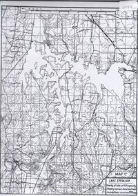
 Bendigo Historical Society Inc.
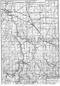
Map - General view of area of proposed construction of Lake Eppalock. Map 'A'
... Permissible activities on the lake include high-speed boating, water skiing, sailing, canoeing, fishing and swimming. ...Permissible activities on the lake include high-speed boating, water skiing, sailing, canoeing, fishing and swimming. ...John Perry Collection. Laminated map of proposed construction of Lake Eppalock. Map 'A'. Black and white map in laminate. Circa 1951. The dam was built by the State Rivers and Water Supply Commission of Victoria. The dam wall height is 45 metres (148 ft) and the main embankment is 1,041 metres (3,415 ft) long. At 100% capacity the dam wall was designed to hold back 304,651 megalitres (6.7014×10¹⁰ imp gal; 8.0480×10¹⁰ US gal) of water. The surface area of Lake Eppalock is 3,011 hectares (7,440 acres) and the catchment area is 2,124 square kilometres (820 sq mi). The controlled spillway is capable of discharging 8,040 cubic metres per second (284,000 cu ft/s). Lake Eppalock supplies both stock and domestic water to the Campaspe irrigation district. It also serves as a water supply to Bendigo and Heathcote and, in more recent times, Ballarat. The lake is a major attraction for those engaging in watersports, with a number of tourist parks and accommodation facilities available. Permissible activities on the lake include high-speed boating, water skiing, sailing, canoeing, fishing and swimming. The lake's water levels were low for approximately eight years between 2002 and 2010 during a prolonged drought, which restricted the amount of recreational activity until rainfall in the latter half of 2010 returned the lake to 100 percent capacity. Built between 1961 and 1964, Lake Eppalock remains the only water storage on the Campaspe River system.map, dam, water, weir, eppalock -
 Bendigo Historical Society Inc.
Map - Black and White map. Outline of Lake Eppalock. Map 'B'
... Permissible activities on the lake include high-speed boating, water skiing, sailing, canoeing, fishing and swimming. ...Permissible activities on the lake include high-speed boating, water skiing, sailing, canoeing, fishing and swimming. ...John Perry Collection. Laminated copy black and white map. Map 'B'. Outline of Lake Eppalcok, overlayed on map. Circa 1951. The dam was built by the State Rivers and Water Supply Commission of Victoria. The dam wall height is 45 metres (148 ft) and the main embankment is 1,041 metres (3,415 ft) long. At 100% capacity the dam wall was designed to hold back 304,651 megalitres (6.7014×10¹⁰ imp gal; 8.0480×10¹⁰ US gal) of water. The surface area of Lake Eppalock is 3,011 hectares (7,440 acres) and the catchment area is 2,124 square kilometres (820 sq mi). The controlled spillway is capable of discharging 8,040 cubic metres per second (284,000 cu ft/s). Lake Eppalock supplies both stock and domestic water to the Campaspe irrigation district. It also serves as a water supply to Bendigo and Heathcote and, in more recent times, Ballarat. The lake is a major attraction for those engaging in watersports, with a number of tourist parks and accommodation facilities available. Permissible activities on the lake include high-speed boating, water skiing, sailing, canoeing, fishing and swimming. The lake's water levels were low for approximately eight years between 2002 and 2010 during a prolonged drought, which restricted the amount of recreational activity until rainfall in the latter half of 2010 returned the lake to 100 percent capacity. Built between 1961 and 1964, Lake Eppalock remains the only water storage on the Campaspe River system.map, water, dam, reservoir, eppalock -
 Bendigo Historical Society Inc.
Map - Black and white map pertaining to Lake Eppalock
... Permissible activities on the lake include high-speed boating, water skiing, sailing, canoeing, fishing and swimming. ...Permissible activities on the lake include high-speed boating, water skiing, sailing, canoeing, fishing and swimming. ...John Perry Collection. Laminated copy of map relating to Lake Eppalock. Lists dwellings, ford crossings and bridges. The dam was built by the State Rivers and Water Supply Commission of Victoria. The dam wall height is 45 metres (148 ft) and the main embankment is 1,041 metres (3,415 ft) long. At 100% capacity the dam wall was designed to hold back 304,651 megalitres (6.7014×10¹⁰ imp gal; 8.0480×10¹⁰ US gal) of water. The surface area of Lake Eppalock is 3,011 hectares (7,440 acres) and the catchment area is 2,124 square kilometres (820 sq mi). The controlled spillway is capable of discharging 8,040 cubic metres per second (284,000 cu ft/s). Lake Eppalock supplies both stock and domestic water to the Campaspe irrigation district. It also serves as a water supply to Bendigo and Heathcote and, in more recent times, Ballarat. The lake is a major attraction for those engaging in watersports, with a number of tourist parks and accommodation facilities available. Permissible activities on the lake include high-speed boating, water skiing, sailing, canoeing, fishing and swimming. The lake's water levels were low for approximately eight years between 2002 and 2010 during a prolonged drought, which restricted the amount of recreational activity until rainfall in the latter half of 2010 returned the lake to 100 percent capacity. Built between 1961 and 1964, Lake Eppalock remains the only water storage on the Campaspe River system.map, water, dam, reservoir, eppalock -
 Bendigo Historical Society Inc.
Map - Black and white map pertaining to Lake Eppalock
... Permissible activities on the lake include high-speed boating, water skiing, sailing, canoeing, fishing and swimming. ...Permissible activities on the lake include high-speed boating, water skiing, sailing, canoeing, fishing and swimming. ...John Perry Collection. Laminated copy of map pertaining to Lake Eppalock. Gives details of dwellings, bridges and ford crossings. The dam was built by the State Rivers and Water Supply Commission of Victoria. The dam wall height is 45 metres (148 ft) and the main embankment is 1,041 metres (3,415 ft) long. At 100% capacity the dam wall was designed to hold back 304,651 megalitres (6.7014×10¹⁰ imp gal; 8.0480×10¹⁰ US gal) of water. The surface area of Lake Eppalock is 3,011 hectares (7,440 acres) and the catchment area is 2,124 square kilometres (820 sq mi). The controlled spillway is capable of discharging 8,040 cubic metres per second (284,000 cu ft/s). Lake Eppalock supplies both stock and domestic water to the Campaspe irrigation district. It also serves as a water supply to Bendigo and Heathcote and, in more recent times, Ballarat. The lake is a major attraction for those engaging in watersports, with a number of tourist parks and accommodation facilities available. Permissible activities on the lake include high-speed boating, water skiing, sailing, canoeing, fishing and swimming. The lake's water levels were low for approximately eight years between 2002 and 2010 during a prolonged drought, which restricted the amount of recreational activity until rainfall in the latter half of 2010 returned the lake to 100 percent capacity. Built between 1961 and 1964, Lake Eppalock remains the only water storage on the Campaspe River system.eppalock, map, water, dam, reservoir -
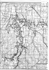
 Bendigo Historical Society Inc.
Map - Map of overlay of lake Eppalock at full capacity. Map 'C'
... Permissible activities on the lake include high-speed boating, water skiing, sailing, canoeing, fishing and swimming. ...Permissible activities on the lake include high-speed boating, water skiing, sailing, canoeing, fishing and swimming. ...John Perry collection. Map 'C'. Laminated map of overlay of Lake Eppalock at full capacity. Circa 1951. The dam was built by the State Rivers and Water Supply Commission of Victoria. The dam wall height is 45 metres (148 ft) and the main embankment is 1,041 metres (3,415 ft) long. At 100% capacity the dam wall was designed to hold back 304,651 megalitres (6.7014×10¹⁰ imp gal; 8.0480×10¹⁰ US gal) of water. The surface area of Lake Eppalock is 3,011 hectares (7,440 acres) and the catchment area is 2,124 square kilometres (820 sq mi). The controlled spillway is capable of discharging 8,040 cubic metres per second (284,000 cu ft/s). Lake Eppalock supplies both stock and domestic water to the Campaspe irrigation district. It also serves as a water supply to Bendigo and Heathcote and, in more recent times, Ballarat. The lake is a major attraction for those engaging in watersports, with a number of tourist parks and accommodation facilities available. Permissible activities on the lake include high-speed boating, water skiing, sailing, canoeing, fishing and swimming. The lake's water levels were low for approximately eight years between 2002 and 2010 during a prolonged drought, which restricted the amount of recreational activity until rainfall in the latter half of 2010 returned the lake to 100 percent capacity. Built between 1961 and 1964, Lake Eppalock remains the only water storage on the Campaspe River system.map, water, eppalock, dam, reservoir -
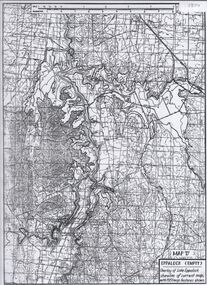 Bendigo Historical Society Inc.
Map - Laminated map of Lake Eppalock empty. Map 'D'
... Permissible activities on the lake include high-speed boating, water skiing, sailing, canoeing, fishing and swimming. ...Permissible activities on the lake include high-speed boating, water skiing, sailing, canoeing, fishing and swimming. ...John Perry Collection. Laminated map of Lake Eppalock empty. Map 'D'. Circa 1951. The dam was built by the State Rivers and Water Supply Commission of Victoria. The dam wall height is 45 metres (148 ft) and the main embankment is 1,041 metres (3,415 ft) long. At 100% capacity the dam wall was designed to hold back 304,651 megalitres (6.7014×10¹⁰ imp gal; 8.0480×10¹⁰ US gal) of water. The surface area of Lake Eppalock is 3,011 hectares (7,440 acres) and the catchment area is 2,124 square kilometres (820 sq mi). The controlled spillway is capable of discharging 8,040 cubic metres per second (284,000 cu ft/s). Lake Eppalock supplies both stock and domestic water to the Campaspe irrigation district. It also serves as a water supply to Bendigo and Heathcote and, in more recent times, Ballarat. The lake is a major attraction for those engaging in watersports, with a number of tourist parks and accommodation facilities available. Permissible activities on the lake include high-speed boating, water skiing, sailing, canoeing, fishing and swimming. The lake's water levels were low for approximately eight years between 2002 and 2010 during a prolonged drought, which restricted the amount of recreational activity until rainfall in the latter half of 2010 returned the lake to 100 percent capacity. Built between 1961 and 1964, Lake Eppalock remains the only water storage on the Campaspe River system.map, water, dam, reservoir, eppalock -
 Bendigo Historical Society Inc.
Map - Laminated map of Lake Eppalock at full capacity
... Permissible activities on the lake include high-speed boating, water skiing, sailing, canoeing, fishing and swimming. ...Permissible activities on the lake include high-speed boating, water skiing, sailing, canoeing, fishing and swimming. ...John Perry Collection. Laminated copy of map of Lake Eppalock at full capacity. Had highlighter markings of old roads which appear to be still in use. The dam was built by the State Rivers and Water Supply Commission of Victoria. The dam wall height is 45 metres (148 ft) and the main embankment is 1,041 metres (3,415 ft) long. At 100% capacity the dam wall was designed to hold back 304,651 megalitres (6.7014×10¹⁰ imp gal; 8.0480×10¹⁰ US gal) of water. The surface area of Lake Eppalock is 3,011 hectares (7,440 acres) and the catchment area is 2,124 square kilometres (820 sq mi). The controlled spillway is capable of discharging 8,040 cubic metres per second (284,000 cu ft/s). Lake Eppalock supplies both stock and domestic water to the Campaspe irrigation district. It also serves as a water supply to Bendigo and Heathcote and, in more recent times, Ballarat. The lake is a major attraction for those engaging in watersports, with a number of tourist parks and accommodation facilities available. Permissible activities on the lake include high-speed boating, water skiing, sailing, canoeing, fishing and swimming. The lake's water levels were low for approximately eight years between 2002 and 2010 during a prolonged drought, which restricted the amount of recreational activity until rainfall in the latter half of 2010 returned the lake to 100 percent capacity. Built between 1961 and 1964, Lake Eppalock remains the only water storage on the Campaspe River system.map, water, dam, reservoir, eppalock -
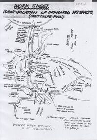 Bendigo Historical Society Inc.
Map - Laminated worksheet - identification of inundated artifacts at Lake Eppalock
... Permissible activities on the lake include high-speed boating, water skiing, sailing, canoeing, fishing and swimming. ...Permissible activities on the lake include high-speed boating, water skiing, sailing, canoeing, fishing and swimming. ...John Perry Collection. Laminated copy of worksheet identifying inundated artifacts at Lake Eppalock when at 10% capacity. The dam was built by the State Rivers and Water Supply Commission of Victoria. The dam wall height is 45 metres (148 ft) and the main embankment is 1,041 metres (3,415 ft) long. At 100% capacity the dam wall was designed to hold back 304,651 megalitres (6.7014×10¹⁰ imp gal; 8.0480×10¹⁰ US gal) of water. The surface area of Lake Eppalock is 3,011 hectares (7,440 acres) and the catchment area is 2,124 square kilometres (820 sq mi). The controlled spillway is capable of discharging 8,040 cubic metres per second (284,000 cu ft/s). Lake Eppalock supplies both stock and domestic water to the Campaspe irrigation district. It also serves as a water supply to Bendigo and Heathcote and, in more recent times, Ballarat. The lake is a major attraction for those engaging in watersports, with a number of tourist parks and accommodation facilities available. Permissible activities on the lake include high-speed boating, water skiing, sailing, canoeing, fishing and swimming. The lake's water levels were low for approximately eight years between 2002 and 2010 during a prolonged drought, which restricted the amount of recreational activity until rainfall in the latter half of 2010 returned the lake to 100 percent capacity. Built between 1961 and 1964, Lake Eppalock remains the only water storage on the Campaspe River system.map, artifacts, eppalock, reservoir -
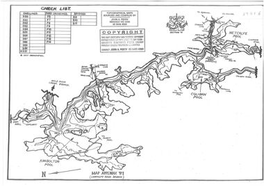
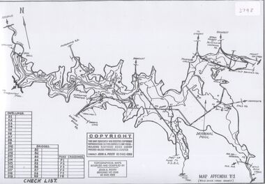
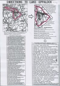 Bendigo Historical Society Inc.
Document - Directions to Lake Eppalock with road descriptions and map
... Permissible activities on the lake include high-speed boating, water skiing, sailing, canoeing, fishing and swimming. ...Permissible activities on the lake include high-speed boating, water skiing, sailing, canoeing, fishing and swimming. ...John Perry Collection. Laminated copy of 'Directions to Lake Eppalock'. Gives directions in relationship of Lake Eppalock to Bendigo, Kyneton and Heathcote. Undated. Gives basic descriptions of bridges on lakebed, ford crossings on lakebed and inundated dwellings on lakebed. The dam was built by the State Rivers and Water Supply Commission of Victoria. The dam wall height is 45 metres (148 ft) and the main embankment is 1,041 metres (3,415 ft) long. At 100% capacity the dam wall was designed to hold back 304,651 megalitres (6.7014×10¹⁰ imp gal; 8.0480×10¹⁰ US gal) of water. The surface area of Lake Eppalock is 3,011 hectares (7,440 acres) and the catchment area is 2,124 square kilometres (820 sq mi). The controlled spillway is capable of discharging 8,040 cubic metres per second (284,000 cu ft/s). Lake Eppalock supplies both stock and domestic water to the Campaspe irrigation district. It also serves as a water supply to Bendigo and Heathcote and, in more recent times, Ballarat. The lake is a major attraction for those engaging in watersports, with a number of tourist parks and accommodation facilities available. Permissible activities on the lake include high-speed boating, water skiing, sailing, canoeing, fishing and swimming. The lake's water levels were low for approximately eight years between 2002 and 2010 during a prolonged drought, which restricted the amount of recreational activity until rainfall in the latter half of 2010 returned the lake to 100 percent capacity. Built between 1961 and 1964, Lake Eppalock remains the only water storage on the Campaspe River system.water, dam, directions, eppalock