Showing 1437 items matching "waterway"
-
 City of Ballarat
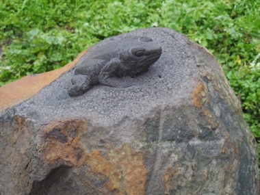
Artwork, other - Public Artwork, Joe Pratt et al, Hidden Waterway, 2016
... Hidden Waterway...To create 'Hidden waterway' (2016) Artist Forest Keegel held workshops with the people of Ballarat East who drew images in the park of threatened local fauna and waterbugs that once inhabited this land. ...City of Ballarat The Phoenix 25 Armstrong Street South Ballarat goldfields To create 'Hidden waterway' (2016) Artist Forest Keegel held workshops with the people of Ballarat East who drew images in the park of threatened local fauna and waterbugs that once inhabited this land. ...To create 'Hidden waterway' (2016) Artist Forest Keegel held workshops with the people of Ballarat East who drew images in the park of threatened local fauna and waterbugs that once inhabited this land. Those images were then translated into carvings by sculptor Joe Pratt across 20 boulders creating a trail throughout the park. The artwork is of aesthetic and social significance to the people of Ballarat20 bluestone boulders with carvings across the surface creating a trail throughout the park forest keegel, joe pratt, ballarat east, pennyweight park -
 Bendigo Military Museum
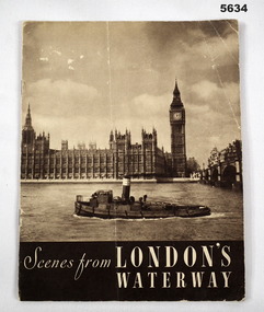
Booklet, The Sun Engraving Co. Ltd, Scenes from London"s Waterway, C1935-1945
... Scenes from London"s Waterway...Scenes from London"s Waterway Booklet BOOKLET The Sun Engraving Co. ...Cardboard covered booklet, Ron cover is a black and white photograph of the Thames, with a tugboat, Parliament House in the background. Inside images of London and the Thames, double decker, tall masted sailing ships. ww2, london, thames river, booklet souvenir -
 Greensborough Historical Society
Book, Melbourne Water, Plenty River Waterway Management Activity Plan 2000, 2000_
... Plenty River Waterway Management Activity Plan 2000....Printed on white paper with black spiral binding and clear plastic front cover. Plenty River Waterway Management Activity Plan 2000. Book Melbourne Water ...This report covers the catchment of the Plenty River from its upper reaches in the Great Dividing Range to the confluence with the Yarra River at Viewbank. It discusses ecological diversity and methods of improving water quality and significant areas of the catchment. Includes a brief history of settlement along the Plenty River.This is a significant plan for the improvement of the Plenty River.207 p., maps, folding maps. Printed on white paper with black spiral binding and clear plastic front cover.plenty river, melbourne water -
 Ballaarat Mechanics' Institute (BMI Ballarat)
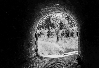
Film - Photograph by Herb Richmond. ca 1971, Creswick- Three Arch Bridge carrying the railway embankment. Two traffic lanes and a waterway. West of Creswick off the road to Bald Hills
... Two traffic lanes and a waterway. West of Creswick off the road to Bald Hills...Two traffic lanes and a waterway. West of Creswick off the road to Bald Hills Film Photograph by Herb Richmond. ca 1971 ...Ballarat History35mm B&W Kodak Plus X Pan Film.ballarat, ballaraat, creswick, three, arch, bridge -
 Ballaarat Mechanics' Institute (BMI Ballarat)
Film - Photograph by Herb Richmond. ca 1971, Creswick- Three Arch Bridge carrying the railway embankment. Two traffic lanes and a waterway. West of Creswick off the road to Bald Hills
... Two traffic lanes and a waterway. West of Creswick off the road to Bald Hills...Two traffic lanes and a waterway. West of Creswick off the road to Bald Hills Film Photograph by Herb Richmond. ca 1971 ...Ballarat History35mm B&W Kodak Plus X Pan Film.ballarat, ballaraat, creswick, three arch, bridge -
 Ballaarat Mechanics' Institute (BMI Ballarat)
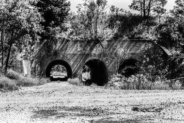
Film - Photograph by Herb Richmond. ca 1971, Creswick- Three Arch Bridge carrying the railway embankment. Two traffic lanes and a waterway. West of Creswick off the road to Bald Hills
... Two traffic lanes and a waterway. West of Creswick off the road to Bald Hills...Two traffic lanes and a waterway. West of Creswick off the road to Bald Hills Film Photograph by Herb Richmond. ca 1971 ...Ballarat History35mm B&W Kodak Plus X Pan Film.ballarat, ballaraat, creswick, three, arch, bridge -
 Ballaarat Mechanics' Institute (BMI Ballarat)
Film - Photograph by Herb Richmond. ca 1971, Creswick- Three Arch Bridge carrying the railway embankment. Two traffic lanes and a waterway. West of Creswick off the road to Bald Hills
... Two traffic lanes and a waterway. West of Creswick off the road to Bald Hills...Two traffic lanes and a waterway. West of Creswick off the road to Bald Hills Film Photograph by Herb Richmond. ca 1971 ...Ballarat History35mm B&W Kodak Plus X Pan Film.ballarat, ballaraat, creswick, three, arch, bridge -
 Ballaarat Mechanics' Institute (BMI Ballarat)
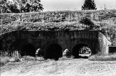
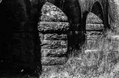
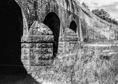
Film - Photograph by Herb Richmond. ca 1971, Creswick- Three Arch Bridge carring the Railway Embankment , Two Traffic Lanes, and a Waterway. West of Creswick off the road to Bald Hills
... Creswick- Three Arch Bridge carring the Railway Embankment , Two Traffic Lanes, and a Waterway. West of Creswick off the road to Bald Hills...Creswick- Three Arch Bridge carring the Railway Embankment , Two Traffic Lanes, and a Waterway. West of Creswick off the road to Bald Hills Film Photograph by Herb Richmond. ca 1971 ...Ballarat History35mm B&W Kodak Plus X Pan Film.ballarat, ballaraat, creswick, arch, bridge -
 Ballaarat Mechanics' Institute (BMI Ballarat)
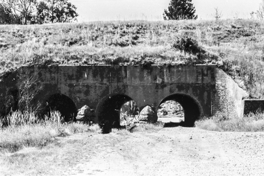
Film - Photograph by Herb Richmond. ca 1971, Creswick- Three Arch Bridge carring the Railway Embankment , Two Traffic Lanes, and a Waterway. West of Creswick off the road to Bald Hills
... Creswick- Three Arch Bridge carring the Railway Embankment , Two Traffic Lanes, and a Waterway. West of Creswick off the road to Bald Hills...Creswick- Three Arch Bridge carring the Railway Embankment , Two Traffic Lanes, and a Waterway. West of Creswick off the road to Bald Hills Film Photograph by Herb Richmond. ca 1971 ...Ballarat History35mm B&W Kodak Plus X Pan Film.ballarat, ballaraat, creswick, arch, bridge -
 Sunshine and District Historical Society Incorporated
Archive - Natural Enviroment
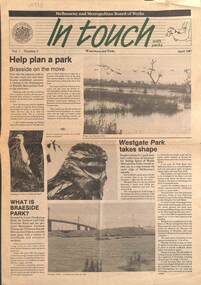
... Collection of documents relating to the enviroment and waterways...2297.01 - Bulletin Volume 1 Number 2 Melbourne and Metropolitan Board of Works In Touch Waterways and Parks April 1987|2297.02 - Extract A Rescue Operation for Kororoit Creek Finding a New Lease of Life for neglected urban waterways|2297.03 - Typed Report State Rivers and Water Supply Commission Press Release The Status of Rivers|2297.04 - Letter Enviroment Protection Authority of Victoria 9 June 1982 To Objectors against S.C.I. ...Creek 2297.01 - Bulletin Volume 1 Number 2 Melbourne and Metropolitan Board of Works In Touch Waterways and Parks April 1987|2297.02 - Extract A Rescue Operation for Kororoit Creek Finding a New Lease of Life for neglected urban waterways|2297.03 - Typed Report State Rivers and Water Supply Commission Press Release The Status of Rivers|2297.04 - Letter Enviroment Protection Authority of Victoria 9 June 1982 To Objectors against S.C.I. ...2297.01 - Bulletin Volume 1 Number 2 Melbourne and Metropolitan Board of Works In Touch Waterways and Parks April 1987|2297.02 - Extract A Rescue Operation for Kororoit Creek Finding a New Lease of Life for neglected urban waterways|2297.03 - Typed Report State Rivers and Water Supply Commission Press Release The Status of Rivers|2297.04 - Letter Enviroment Protection Authority of Victoria 9 June 1982 To Objectors against S.C.I. Meat & Paper Pty Ltd to discharge waste to air Dohertys Road Laverton North|2297.05 - Talk for SGAP Keilor Plains Group - Managing the natural assets of Brimbank - Sites of biological significance as identified in the Brimbank Natural Heritage Strategycreek -
 Surrey Hills Historical Society Collection
Book, Exploring Gardiner's Creek and its tributaries in southern Camberwell, 1994
... This book describes geographical landmarks and especially waterways that of the City of Camberwell (now City of Boroondara)....This book describes geographical landmarks and especially waterways that of the City of Camberwell (now City of Boroondara)....Surrey Hills Historical Society Collection 190A Canterbury Road Canterbury melbourne This book describes geographical landmarks and especially waterways that of the City of Camberwell (now City of Boroondara). gardiner's creek (mr) john gardiner koonung creek back creek glass's creek w creek west creek ashburton creek delaney's creek walking trails rivers This book describes geographical landmarks and especially waterways that of the City of Camberwell (now City of Boroondara). ...This book describes geographical landmarks and especially waterways that of the City of Camberwell (now City of Boroondara).This book describes geographical landmarks and especially waterways that of the City of Camberwell (now City of Boroondara).gardiner's creek, (mr) john gardiner, koonung creek, back creek, glass's creek, w creek, west creek, ashburton creek, delaney's creek, walking trails, rivers -
 Greensborough Historical Society
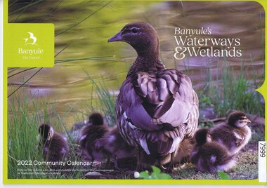
Calendar, Banyule City Council, Banyule Community Calendar 2022: Banyule's Waterways & Wetlands, 2022
... The 2022 calendar contains action photographs of local waterways and wetlands. Some council services are detailed in the back pages....Illustrations of local waterways and wetlands. ...Illustrations of local waterways and wetlands. Banyule Community Calendar 2022: Banyule's Waterways & Wetlands Calendar Banyule City Council ...This community calendar is distributed to residents of the City of Banyule each year. Each year it focusses on an aspect of the local community. The 2022 calendar contains action photographs of local waterways and wetlands. Some council services are detailed in the back pages.The annual report is a record of the activities and services in the Banyule City Council area.30 pages. Colour illustrations. Illustrations of local waterways and wetlands. banyule city council, banyule community calendar, rivers, wetlands -
 Surrey Hills Historical Society Collection
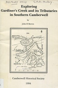
Book, Exploring Gardiner's Creek and its tributaries in southern Camberwell, 1994
... This book describes geographical landmarks, in particular the waterways, that make up the City of Camberwell (now City of Boroondara)....This book describes geographical landmarks, in particular the waterways, that make up the City of Camberwell (now City of Boroondara)....Surrey Hills Historical Society Collection 190A Canterbury Road Canterbury melbourne This book describes geographical landmarks, in particular the waterways, that make up the City of Camberwell (now City of Boroondara). gardiner's creek (mr) john gardiner koonung creek back creek glass's creek w creek west creek ashburton creek delaney's creek walking trails rivers creeks glass creek This book describes geographical landmarks, in particular the waterways, that make up the City of Camberwell (now City of Boroondara). ...This book describes geographical landmarks, in particular the waterways, that make up the City of Camberwell (now City of Boroondara).This book describes geographical landmarks, in particular the waterways, that make up the City of Camberwell (now City of Boroondara).gardiner's creek, (mr) john gardiner, koonung creek, back creek, glass's creek, w creek, west creek, ashburton creek, delaney's creek, walking trails, rivers, creeks, glass creek -
 Greensborough Historical Society
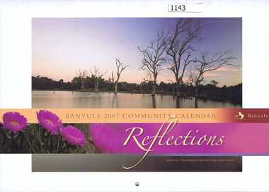
Calendar, Banyule City Council, Banyule Community Calendar 2007: Reflections - Banyule's waterways, native flora and fauna, 2007_
... The 2007 calendar contains photographs of Banyule's waterways, native flora and fauna. Some council services are detailed in the back pages...Colour illustrations of Banyule's waterways, native flora and fauna...Colour illustrations of Banyule's waterways, native flora and fauna Banyule Community Calendar 2007: Reflections - Banyule's waterways, native flora and fauna. ...This community calendar is distributed to residents of the City of Banyule each year. Each year it focusses on an aspect of the local community. The 2007 calendar contains photographs of Banyule's waterways, native flora and fauna. Some council services are detailed in the back pagesThe annual calendar is a record of the activities and services in the Banyule City Council area28 pages. Colour illustrations of Banyule's waterways, native flora and faunabanyule city council, banyule community calendar -
Tatura Irrigation & Wartime Camps Museum
Book, Nagambie Waterways The way they were, May 2009
... History of the Goulburn Irrigation System and the waterways....There are 92 pages with many B/W photos detailing the history of the waterways....There are 92 pages with many B/W photos detailing the history of the waterways. Nagambie Waterways The way they were Book Elaine Lodding ...History of the Goulburn Irrigation System and the waterways.Collection of early photographs of the area telling the history.Rectangular shaped book, Cover is a B/W photo of the 'Merriwee', boat, owned by W. L Forbes C 1920 with a group of people on board about to enjoy a sailing. There are 92 pages with many B/W photos detailing the history of the waterways.Credits page, supported by the Strathbogie Shire Council.and Nagambie Historical Society.irrigation history, lake nagambie, goulburn weir and environs, life in the area -
 Lakes Entrance Historical Society
Photograph - Lake Tyers Victoria c1905, Caire, Nicholas John, 1905c
... View of one of the lakes on the Lake Tyers river system showing a calm waterway and timbered banks Small paddle boat 'Sunbeam' used as tourist launch...Black and white photograph of a view of one of the lakes on the Lake Tyers system showing a calm waterway and densely timbered banks. There is a small steamboat anchored in the lake. ...Lakes Entrance Historical Society 4 Marine Parade Lakes Entrance gippsland View of one of the lakes on the Lake Tyers river system showing a calm waterway and timbered banks Small paddle boat 'Sunbeam' used as tourist launch Waterways Boats and Boating Tourism Black and white photograph of a view of one of the lakes on the Lake Tyers system showing a calm waterway and densely timbered banks. ...View of one of the lakes on the Lake Tyers river system showing a calm waterway and timbered banks Small paddle boat 'Sunbeam' used as tourist launchBlack and white photograph of a view of one of the lakes on the Lake Tyers system showing a calm waterway and densely timbered banks. There is a small steamboat anchored in the lake. Lake Tyers Victoriawaterways, boats and boating, tourism -
 Linton and District Historical Society Inc
Photograph, Linton Reservoir from Mortchup Road, undated
... Small black and white image of a waterway....Linton and District Historical Society Inc 69 Sussex Street Linton 3360 goldfields Linton Reservoir Small black and white image of a waterway. Linton Reservoir from Mortchup Road, undated Photograph ...Small black and white image of a waterway.linton reservoir -
 Sunbury Family History and Heritage Society Inc.
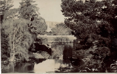
Postcard
... The photograph was taken in the grounds of Rupertswood, William Clarke's country mansion. The waterway is the Jackson Creek and the bridge spanning the creek is one of four along the Sunbury - Bendigo railway line. ...A non-digital black and white photograph in postcard format of a bridge spanning a waterway with tall trees on either side. The tall tower of a building is visible in the distance. ...Sunbury Global Learning Centre Macedon Street Sunbury melbourne The photograph was taken in the grounds of Rupertswood, William Clarke's country mansion. The waterway is the Jackson Creek and the bridge spanning the creek is one of four along the Sunbury - Bendigo railway line. ...The photograph was taken in the grounds of Rupertswood, William Clarke's country mansion. The waterway is the Jackson Creek and the bridge spanning the creek is one of four along the Sunbury - Bendigo railway line. Rupertswood Mansion is visible in the distance.A non-digital black and white photograph in postcard format of a bridge spanning a waterway with tall trees on either side. The tall tower of a building is visible in the distance. The sender, Bridget, who was at Rupertswood, has written a note on the back to Hal Eadie in Dannevirke in NZ. It is not possible to read the message because at some stage some brown paper was pasted on the card.rupertswood mansion, jacksons creek, railway viaduct bridge, bendigo rail line, railway viaduct, sunbury -
 Lakes Entrance Historical Society
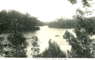
Photograph - Rippling Straits, Nowa Nowa Arm
... Black and white digital photo of waterways with a canoe...Waterways Topography Rippling Straits, Nowa Nowa Arm Black and white digital photo of waterways with a canoe Photograph Rippling Straits, Nowa Nowa Arm ...Black and white digital photo of waterways with a canoeRippling Straits, Nowa Nowa Armwaterways, topography -
Lakes Entrance Historical Society
Map - Lake Tyers Forest and Waterways
... Map of Lake Tyers showing forest and waterways....Lakes Entrance Historical Society 4 Marine Parade Lakes Entrance gippsland Forest Waterways Highways Map of Lake Tyers showing forest and waterways. ...Map of Lake Tyers showing forest and waterways.forest, waterways, highways -
 Lakes Entrance Historical Society
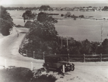
Photograph - Princes Highway around Jemmys Point, Lakes Entrance, H D Bulmer, 1930 c
... Bullock Island and New Works in distance over North Arm and Cunninghame Arm waterways Lakes Entrance Victoria...Bullock Island and New Works in distance over North Arm and Cunninghame Arm waterways Lakes Entrance Victoria...Bullock Island and New Works in distance over North Arm and Cunninghame Arm waterways Lakes Entrance Victoria Roads and Streets Township Waterways Fences Vehicles Black and white photograph of lower section of Princes Highway around Jemmys Point, car parked on road at junction of original steep road to top of Jemmys Point. ...Princes Highway around Jemmys Point, car parked on road at junction of original steep road to top of Jemmys Point. Man on bicycle riding up hill. Bullock Island and New Works in distance over North Arm and Cunninghame Arm waterways Lakes Entrance VictoriaBlack and white photograph of lower section of Princes Highway around Jemmys Point, car parked on road at junction of original steep road to top of Jemmys Point. Man on bicycle riding up hill. Bullock Island and New Works in distance over North Arm and Cunninghame Arm waterways Lakes Entrance Victoriaroads and streets, township, waterways, fences, vehicles -
Tatura Irrigation & Wartime Camps Museum
Pamphlet, Goulburn River Country, 1990
... Tour guide of Goulburn Valley waterways, wineries, wilderness...Tatura Irrigation & Wartime Camps Museum 49 Hogan Street Tatura the-murray To advertise Goulburn Valley Tourist destinations local tourism documents pamphlets Tour guide of Goulburn Valley waterways, wineries, wilderness Goulburn River Country Pamphlet ...To advertise Goulburn Valley Tourist destinationsTour guide of Goulburn Valley waterways, wineries, wildernesslocal tourism, documents, pamphlets -
Lakes Entrance Historical Society
Map - Plan of Township of Lakes Entrance
... Plan of township of Lakes Entrance showing waterways and land owners...Lakes Entrance Historical Society 4 Marine Parade Lakes Entrance gippsland Township Waterways Maps Plan of township of Lakes Entrance showing waterways and land owners Map Plan of Township of Lakes Entrance ...Plan of township of Lakes Entrance showing waterways and land ownerstownship, waterways, maps -
 Port Fairy Historical Society Museum and Archives
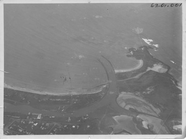
Photograph, R.W.Golding, 1925
... Black and White aerial view of Port Fairy ‘s waterways...Port Fairy Historical Society Museum and Archives 30 Gipps Street Port Fairy great-ocean-road taken in 1925 by W Golding Aerial-Port Fairy Harbour 1925 aerial view harbour griffiths island w.golding training walls 62.01.001 on front of photograph - on the back-Port Fairy Moyne River Entrance W Golding Black and White aerial view of Port Fairy ‘s waterways Photograph Photograph R.W.Golding ...taken in 1925 by W Golding Aerial-Port Fairy Harbour 1925Black and White aerial view of Port Fairy ‘s waterways62.01.001 on front of photograph - on the back-Port Fairy Moyne River Entrance W Goldingaerial view, harbour, griffiths island, w.golding, training walls -
Tatura Irrigation & Wartime Camps Museum
Album - Photograph, P. Hampton
... plastic photograph album coloured waterway scene, barges, houses on bank....Hampton plastic photograph album coloured waterway scene, barges, houses on bank. P. Hampton Album - Photograph ...Given to M. Normington by A. Hampton (brother of P. Hampton) for Tatura Museum. Includes post cards sent from France to his family. Photograph of his grave in France.plastic photograph album coloured waterway scene, barges, houses on bank.p. hampton -
 Linton and District Historical Society Inc
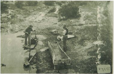
Photograph, Two Men Cradling for Gold
... Black and white image of two men cradling for gold beside a waterway....Cradling Gold Black and white image of two men cradling for gold beside a waterway. Two Men Cradling for Gold Photograph ...An early index to LDHS photographs says it was taken at Dawson's Dam, and is of fossickers re-working the sludge.Black and white image of two men cradling for gold beside a waterway.cradling, gold -
Lakes Entrance Historical Society
Photograph - Framed photograph , aerial view of waterway and housing area from Kalimna, 2002c
... Mounted photograph, aerial view of waterway and housing area from Kalimna...Mounted on chipboard, rear of backboard has strap for wall hanging PHOTOGRAPHY Photographs Slides Film Mounted photograph, aerial view of waterway and housing area from Kalimna Photograph Framed photograph , aerial view of waterway and housing area from Kalimna The Picture Factory Aust Pty Ltd Heidelberg ...Mounted on chipboard, rear of backboard has strap for wall hangingMounted photograph, aerial view of waterway and housing area from Kalimnaphotography, photographs, slides, film -
Lakes Entrance Historical Society
Map - Mining Inspectors Districts Victoria
... Areas are Nos. 1,2,3,4,5,6. Waterways...Areas are Nos. 1,2,3,4,5,6. Waterways Map Mining Inspectors Districts Victoria ...Inspectors Area 1 S C Phillips, Area 2 F Vincent, Area 3 W G Foley, Area 4 J E Salter, Area 5 H Baird, Area 6 T Bonner.Map shows from Millewa to the N.S.W. border. Areas are Nos. 1,2,3,4,5,6. Waterwaysmining, government -
 Lakes Entrance Historical Society
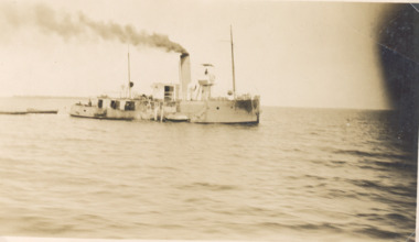
Photograph - Dredge W H Edgar, Gippsland Lakes Victoria, 1926
... Black and white photograph of dredge W H Edgar in waterway Gippsland Lakes Victoria...Lakes Entrance Historical Society 4 Marine Parade Lakes Entrance gippsland Waterways Engineering Dredges Black and white photograph of dredge W H Edgar in waterway Gippsland Lakes Victoria Dredge W H Edgar, Gippsland Lakes Victoria Photograph Dredge W H Edgar, Gippsland Lakes Victoria ...Black and white photograph of dredge W H Edgar in waterway Gippsland Lakes Victoriawaterways, engineering, dredges -
 Lakes Entrance Historical Society
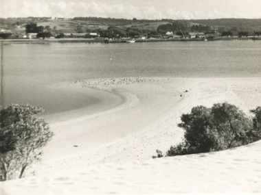
Photograph - Sand hummocks Lakes Entrance c1950
... Also three photographs taken from similar location looking over waterway ...Lakes Entrance Historical Society 4 Marine Parade Lakes Entrance gippsland Waterways Vegetation Houses Township Black and white photograph taken from the sand hummocks looking across Cunninghame Arm waterway to jetties and buildings along Esplanade Lakes Entrance c1950 . ...Black and white photograph taken from the sand hummocks looking across Cunninghame Arm waterway to jetties and buildings along Esplanade Lakes Entrance c1950 . Also three photographs taken from similar location looking over waterway waterways, vegetation, houses, township