Showing 97 items matching "wattle tree"
-
 Eltham District Historical Society Inc
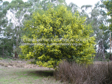
Photograph, Fay Bridge, Wattle tree, Sweeneys Flats, Eltham, 26 August 2019
... Wattle tree, Sweeneys Flats, Eltham......wattle tree...Eltham District Historical Society Inc 728 Main Rd Eltham melbourne Fay Bridge Collection Sweeneys Flats wattle tree 2019-08-26 1 image - born digital Wattle tree, Sweeneys Flats, Eltham Photograph Photograph Fay Bridge ...fay bridge collection, sweeneys flats, wattle tree, 2019-08-26 -
 Korowa Anglican Girls' School
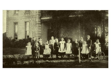
Photograph, Students outside 'Old Korowa' at Wattle Tree Road c1900
... Students outside 'Old Korowa' at Wattle Tree Road c1900...Korowa Anglican Girls' School 10-16 Ranfurlie Cres Glen Iris Earliest image of Korowa students Small sepia image Students outside 'Old Korowa' at Wattle Tree Road c1900 Photograph Photograph ...Earliest image of Korowa students -
 Melbourne Tram Museum
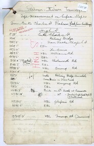
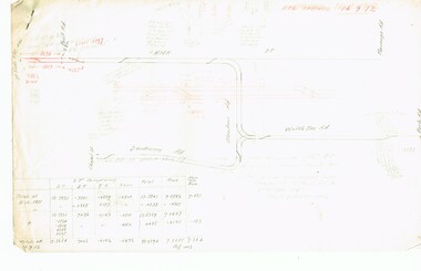
Document - Research Notes, Mr. Mainwaring, PMTT surface slopes, 1910
... ... Wattle Tree Rd...Three ruled foolscap sheets, tied in the top left hand corner with string, headed Prahran Malvern Tramways - tape measurement of surface slopes from High Street, Glenferrie Road Wattle tree Road to Burke Road. Prepared by Mr Mainwaring in black and red ink. ...Melbourne Tram Museum 8 Wallen Road Hawthorn melbourne Trams tramways PMTT Malvern Surveys High St Wattle Tree Rd Burke Rd Three ruled foolscap sheets, tied in the top left hand corner with string, headed Prahran Malvern Tramways - tape measurement of surface slopes from High Street, Glenferrie Road Wattle tree Road to Burke Road. ...Three ruled foolscap sheets, tied in the top left hand corner with string, headed Prahran Malvern Tramways - tape measurement of surface slopes from High Street, Glenferrie Road Wattle tree Road to Burke Road. Prepared by Mr Mainwaring in black and red ink. Dated 30.6.1910. Items 2041 to 2052 within box 72.3 in a brown folder marked "PMTT" in red pencil.trams, tramways, pmtt, malvern, surveys, high st, wattle tree rd, burke rd -
 Melbourne Tram Museum
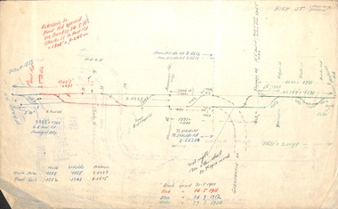
Document - Research Notes, H. S. McComb, Extracts of PMTT Minutes - track layouts, 1950's
... ... Wattle Tree Rd...McComb - gives layout of the PMTT system, primarily of Burke Road, sketches of track layout, opening dates, sketches of various junctions, bridges, track miles, junctions, reconciliation of track lengths from various sources of High St Malvern, extension to Punt Road and St Kilda Roads includes duplications and a Wattle Tree Road. Items 2041 to 2052 within box 72.3 in a brown folder marked "PMTT" in red pencil....Melbourne Tram Museum 8 Wallen Road Hawthorn melbourne Trams tramways PMTT Malvern Routes Track Surveys Punt Rd High St Wattle Tree Rd Duplications Set of papers, handwritten concerning the development and timing of the "PMTT", Prahran and Malvern - 6 sheets. ...Set of papers, handwritten concerning the development and timing of the "PMTT", Prahran and Malvern - 6 sheets. Prepared by H. S. McComb - gives layout of the PMTT system, primarily of Burke Road, sketches of track layout, opening dates, sketches of various junctions, bridges, track miles, junctions, reconciliation of track lengths from various sources of High St Malvern, extension to Punt Road and St Kilda Roads includes duplications and a Wattle Tree Road. Items 2041 to 2052 within box 72.3 in a brown folder marked "PMTT" in red pencil.trams, tramways, pmtt, malvern, routes, track, surveys, punt rd, high st, wattle tree rd, duplications -
 Melbourne Tram Museum
Document - Research Notes, H. S. McComb, development and timing of the "PMTT" - part 5, 1950's
... ... Wattle Tree Rd...McComb - gives layout of the PMTT system, primarily of Burke Road, sketches of track layout, opening dates, sketches of various junctions, bridges, track miles, junctions, reconciliation of track lengths from various sources includes High St Malvern, extension to Punt Road, Dandenong Road, Wattle Tree Road, including its duplication Items 2041 to 2052 within box 72.3 in a brown folder marked "PMTT" in red pencil....Melbourne Tram Museum 8 Wallen Road Hawthorn melbourne Trams tramways PMTT Malvern Routes Track Surveys Wattle Tree Rd Punt Rd Dandenong Rd High St Duplications Set of papers, handwritten concerning the development and timing of the "PMTT", Prahran and Malvern - about 20 sheets. ...Set of papers, handwritten concerning the development and timing of the "PMTT", Prahran and Malvern - about 20 sheets. Prepared by H. S. McComb - gives layout of the PMTT system, primarily of Burke Road, sketches of track layout, opening dates, sketches of various junctions, bridges, track miles, junctions, reconciliation of track lengths from various sources includes High St Malvern, extension to Punt Road, Dandenong Road, Wattle Tree Road, including its duplication Items 2041 to 2052 within box 72.3 in a brown folder marked "PMTT" in red pencil.trams, tramways, pmtt, malvern, routes, track, surveys, wattle tree rd, punt rd, dandenong rd, high st, duplications -
 Federation University Art Collection
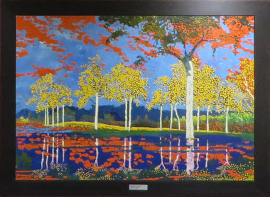
Painting - Artwork - Painting, Reinhard Gromm, Wattle, c1996
... A landscape painting on canvas featuring wattle trees....The Art Collection features over 2000 works and was listed as a 'Ballarat Treasure' in 2007. art artwork reinhard gromm gromm landscape flora Horsham Campus Art Collection A landscape painting on canvas featuring wattle trees. Wattle Painting Artwork - Painting Reinhard Gromm ...This item is part of the Federation University Art Collection. The Art Collection features over 2000 works and was listed as a 'Ballarat Treasure' in 2007.A landscape painting on canvas featuring wattle trees.art, artwork, reinhard gromm, gromm, landscape, flora, horsham campus art collection -
 Glen Eira Historical Society
Document - Racing Stables In Caulfield
... ... Wattle Tree Hotel...Clubs and associations Victorian Amateur Turf Club Racecourses Caulfield Race Course Racecourse Trainers Stables Racehorses Schools Secondary School Caulfield High School Hotels Caulfield Club Hotel Wattle Tree Hotel Petrol Stations Veterinarian Clinic Norman Myers Veterinarian Hospital Baker Norma Bence J. ...This file contains 3 items. 1/ Document provided by Veterinarian Dr G. G. Heslop about racing stables in the Caulfield area adjacent to the Caulfield Race Course, in both typed and handwritten form. 2/ A letter of request from a Sydney based sports writer Geoff Armstrong for information about the attempted shooting for Phar Lap. 3/ A letter to the Editor in the Glen Eira/Port Phillip Leader dated 02/04/2013 about the proposal to ban horse training from the Caulfield Racecourse.clubs and associations, victorian amateur turf club, racecourses, caulfield race course, racecourse trainers, stables, racehorses, schools, secondary school, caulfield high school, hotels, caulfield club hotel, wattle tree hotel, petrol stations, veterinarian clinic, norman myers veterinarian hospital, baker norma, bence j., bird j., cadby lou, conaghan basil, cameron ron, couseng harry, cox cecil, creighton norman, delaney g., eules darce, farmer h. (dick), fraser mick, foulsham fred, fryer j., gatell harry, garton a. (rod), garland f., godby cecil, godby frank, goodfellow claude, guinane p., hayes t. j., hilton h., hodgkinson george, james jack, jenkins e. j., jennings reg, judd des, jury jack, king frank, mcgregor j. n., mcnamara dave, mcphee sonny, mclaughlin, mulcahy j., murphy geoff, muskett j., parkinson j., phillipson mr., quinlan pat, ralph stan, reid stanley, robinson f., rolfe w. j., sanderson chris, telford w., tie jerry, torr harry, bernborough, black caviar, garryowen, phar lap, purser, revenue, spearfelt, surround, arthur jr., murrel violet, farmer violet, kemball w. r., mcdonald leslie, brockhoff mr., carslake mr., gullifer h., heywood j. g., llord mr., davies mr., palfreman mr., caulfield, caulfield north, caulfield south, carnegie, glen huntly, glenhuntly, eskdale road, balaclava road, bambra road, glen eira road, heywood street, hudson street, hawthorn road, kambrook road, kooyong road, tudor court, lloyds paddock, payne street, park crescent, service street, slaney’s paddock, station street, booran road, ‘moidart’, cadby court, glen huntly road, glenhuntly road, neerim road, ‘cintra’, stephen street, uranda line grove, willgra road, epsom street, lloyds street, lord street, queens avenue, st vincents street, roseberry grove, manchester grove, safeway supermarket, hesop g. g. dr veterinary surgeon -
 Melbourne Tram Museum
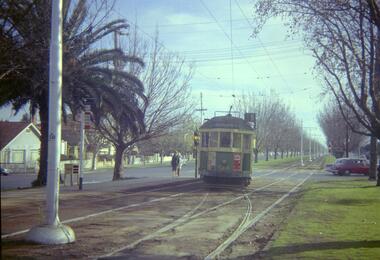
Negative - Set of 2, Travis Jeffrey, 10/06/1962 12:00:00 AM
... ... Wattle Tree Rd...Melbourne Tram Museum 8 Wallen Road Hawthorn melbourne Trams tramways W2 class Route 5 Dandenong Rd Wattle Tree Rd Malvern Burke Rd tram 514 Paper folder that contained the negative had "NR77B" and date written as 10 Jun 62 in red ink., Paper folder that contained the negative had "NR76B" and date written as 10 Jun 62 in red ink. ...Colour negative of tram 514 in Dandenong Road. Tram has destination Malvern - Burke Rd and Route No 5. Photo shows tram shunting. Note the newspaper box on the left hand side of the photograph. , Colour negative of tram 514 in Wattletree Road at Burke Rd terminus. Tram has destination City and Route No 5. Note thePaper folder that contained the negative had "NR77B" and date written as 10 Jun 62 in red ink., Paper folder that contained the negative had "NR76B" and date written as 10 Jun 62 in red ink.trams, tramways, w2 class, route 5, dandenong rd, wattle tree rd, malvern burke rd, tram 514 -
 Melbourne Tram Museum
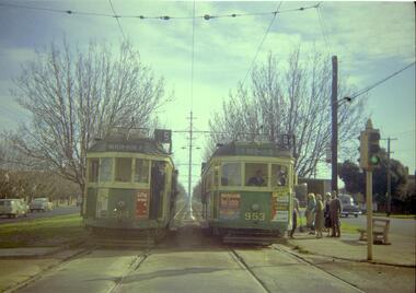
Negative, Travis Jeffrey, 10/06/1962 12:00:00 AM
... ... Wattle Tree Rd...Melbourne Tram Museum 8 Wallen Road Hawthorn melbourne Trams tramways W2 class Route 5 Route 64 Dandenong Rd Wattle Tree Rd Malvern Burke Rd tram 514 tram 953 Paper folder that contained the negative had "NR75B" and date written as 10 Jun 62 in red ink. ...Colour negative of trams 514 and 953 in Dandenong Road. Tram 514 has destination Malvern - Burke Rd and Route No 5. Photo shows tram on the left track (city-bound), although facing towards its destination (Malvern). Driver standing in door of cab and conductor standing in doorway to tram. Tram 953 has destination East Brighton via Caulfield and Route No 64. Sign on front states: "Connect with Malvern-Burke Rd tram".Paper folder that contained the negative had "NR75B" and date written as 10 Jun 62 in red ink.trams, tramways, w2 class, route 5, route 64, dandenong rd, wattle tree rd, malvern burke rd, tram 514, tram 953 -
 Melbourne Tram Museum
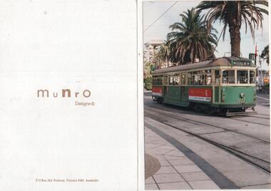
Ephemera - Greetings Card, Munro Designs, 1990's
... ... Wattle Tree Rd...Melbourne Tram Museum 8 Wallen Road Hawthorn melbourne Trams tramways The Esplanade St Kilda Wattle Tree Rd Route 15 W7 class tram 1022 Greeting Card printed on white card, folded featuring a Postcard - full colour of W7 1022 in the Esplanade St Kilda with the destination of Wattletree Road corner, route 15. ...Greeting Card printed on white card, folded featuring a Postcard - full colour of W7 1022 in the Esplanade St Kilda with the destination of Wattletree Road corner, route 15. Tram has external advertising for Qantas. The card has in ink on the bottom right hand corner "Rob Munro" - hold card at an angle. On the rear "Munro Designs" and the Postal address in Prahran.trams, tramways, the esplanade, st kilda, wattle tree rd, route 15, w7 class, tram 1022 -
 Bendigo Historical Society Inc.
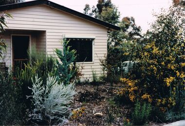
Photograph - PETER ELLIS COLLECTION: HOUSE AND GARDEN
... House and native garden. Wattle tree on right. Car slightly visable through trees....House and native garden. Wattle tree on right. Car slightly visable through trees. ...Colour photograph. House and native garden. Wattle tree on right. Car slightly visable through trees.buildings, house, unknown -
 Kiewa Valley Historical Society
Hankerchief
... The blue print is a picture of mountains with snow and with wattle trees in the foreground and with the words Mount Beauty Victoria....The blue print is a picture of mountains with snow and with wattle trees in the foreground and with the words Mount Beauty Victoria. ...Mount Beauty is a tourist destination and this 'hanky' may have been a souvenir.Since the completion of the Kiewa Hydro Electric Scheme Mount Beauty has become a tourist destination. The 'hanky' depicts the snow on the mountains and nature as an advertisement for visiting the town and its surrounds.White cotton handkerchief with lace edges and a blue print in one corner. The blue print is a picture of mountains with snow and with wattle trees in the foreground and with the words Mount Beauty Victoria.mount beauty tourism, handkerchief -
Glenelg Shire Council Cultural Collection
Administrative record - Ticket - souvenir of Edward Henty, 1934
... Sketch of Bronze wing pigeon. Poem. Golden Wattle tree - photo. Folds into 4 sections....Sketch of Bronze wing pigeon. Poem. Golden Wattle tree - photo. Folds into 4 sections. Administrative record Ticket - souvenir of Edward Henty Stockland Press N.1 ...Portland CentenaryPhoto of Edward Henty on cover in decorative edging. Pioneer Breakfast and Picnic. Sketch of Bronze wing pigeon. Poem. Golden Wattle tree - photo. Folds into 4 sections.Front: Souvenir Ticket 1934-1935 Centenary. Hand written on top - I trust that you will soon be well ?.S. -
 Halls Gap & Grampians Historical Society
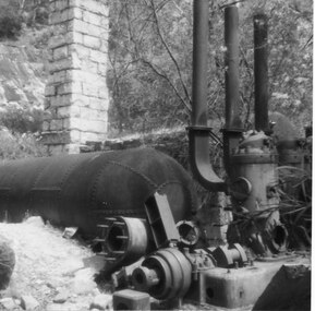
Photograph - Coloured, C 1960s (?)
... Stone chimney is also visible, however because of close-up view top of chimney cannot be seen. Wattle tree in bloom is visible in top right corner....Stone chimney is also visible, however because of close-up view top of chimney cannot be seen. Wattle tree in bloom is visible in top right corner. ...Photo shows close-up view of steam boiler equipment. Stone chimney is also visible, however because of close-up view top of chimney cannot be seen. Wattle tree in bloom is visible in top right corner.quarrying, heatherlie -
 Greensborough Historical Society
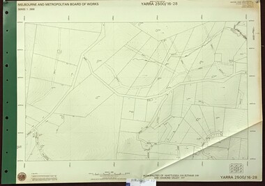
Map, Melbourne and Metropolitan Board of Works. Survey Division, MMBW, Yarra 2500 / 16.28. East of Hurstbridge, 1977_10
... Prominent streets include: Boyds Road, Bannons Lane and Wattle Tree Road. ...Prominent streets include: Boyds Road, Bannons Lane and Wattle Tree Road. mmbw melbourne and metropolitan board of works shire of diamond valley MMBW Map in 1:2500 [scale] series. ...Melbourne and Metropolitan Board of Works. Yarra 2500 [base map] 16.28. East of Hurstbridge. Municipalities of Whittlesea 239, Eltham 238 and Diamond Valley 257. Prominent streets include: Boyds Road, Bannons Lane and Wattle Tree Road. MMBW Map in 1:2500 [scale] series. Cream parchment with green tape reinforcing on edges and punched holes on left edge.mmbw, melbourne and metropolitan board of works, shire of diamond valley -
 Bendigo Historical Society Inc.
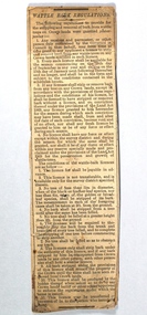
Ephemera - Newspaper cutting of Wattle Bark Regulations, 03/05/1884
... There are four points listed with the fourth point referring to the Land Act 1869 for the preservation and growth of wattle trees. There is another 11 points listed under the heading The conditions of the wattle-bark licences are as follows ...There are four points listed with the fourth point referring to the Land Act 1869 for the preservation and growth of wattle trees. There is another 11 points listed under the heading The conditions of the wattle-bark licences are as follows Ephemera Newspaper cutting of Wattle Bark Regulations ...Wattlebark was stripped from trees to be processed to create tannin for the tanning of leather. Yellow paper with black printing attached to a piece of a cardboard calendar dated 1877. the article is headed WATTLE BARK REGULATIONS. There are four points listed with the fourth point referring to the Land Act 1869 for the preservation and growth of wattle trees. There is another 11 points listed under the heading The conditions of the wattle-bark licences are as follows bendigo, wattle bark regulations, newspaper cutting -
 Orbost & District Historical Society
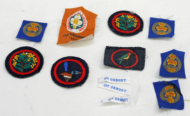
badges, 1950's -1960's
... They are unused Girl Guide badges. two are round with a black background and inside a red circle is a wattle tree. One is round with a variegated fairy wren inside a red circle. ...They are unused Girl Guide badges. two are round with a black background and inside a red circle is a wattle tree. One is round with a variegated fairy wren inside a red circle. ...These badges are unused and were possibly available for those guides who took part in the various camps or became new members. they were designed to sew on to the guide uniforms or blankets. Nancye Wallace (nee Warren) was a Guide leader.Established in 1910, Girl Guiding is now one of the largest all female organisations in the world. It is designed for girls, young and not-so-young women to join and enjoy a program of informal learning, opportunities, fun, personal development and friendship. (ref. Girl Guides Victoria). These badges used by an Orbost local reflects the history of that organisation in Orbost.Twelve cloth badges. They are unused Girl Guide badges. two are round with a black background and inside a red circle is a wattle tree. One is round with a variegated fairy wren inside a red circle. One is rectangular with an eastern rosella inside a red circle. There are four smaller square shaped badges (cut from a strip) with gold, and red print on a blue background - " 1910 Girl Guides Jubilee 1960". One is a rectangular Camp Kindamindi badge and there are three rectangular strips, white with blue print "1st Orbost".badges-cloth girl-guides -
 Eltham District Historical Society Inc
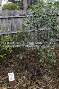
Photograph, Peter Pidgeon, Dedication of a Golden Wattle in memory of Harry Gilham and Sue Law, Local History Centre, 728 Main Road, Eltham, 12 April 2024
... A Golden Wattle tree was planted in memory of Eltham District Historical Society life members Harry Gilham (24 Mar 1928-25 Feb 2024; EDHS President 1993-2009) and Sue Law (27 Sep 1937-8 Aug 2023; EDHS President 1985-1993, Vice President 1993-1998 & 2009-2015). ...Eltham District Historical Society Inc 728 Main Rd Eltham melbourne A Golden Wattle tree was planted in memory of Eltham District Historical Society life members Harry Gilham (24 Mar 1928-25 Feb 2024; EDHS President 1993-2009) and Sue Law (27 Sep 1937-8 Aug 2023; EDHS President 1985-1993, Vice President 1993-1998 & 2009-2015). ...A Golden Wattle tree was planted in memory of Eltham District Historical Society life members Harry Gilham (24 Mar 1928-25 Feb 2024; EDHS President 1993-2009) and Sue Law (27 Sep 1937-8 Aug 2023; EDHS President 1985-1993, Vice President 1993-1998 & 2009-2015). Close members of Harry’s and Sue’s families along with EDHS Committee members and life member Doug Orford joined in a dedication ceremony to commemorate their contributions, on Friday 12 April at 10.00am, in the rear yard at the Local History Centre, 728 Main Road, Eltham, on the corner of Brougham Street. EDHS President Jim Connor welcomed family members and acknowledged the dedicated efforts of both Harry and Sue over a long period of years. After unveiling of the plaque, attendees enjoyed some morning tea and sharing stories of Harry and Sue.Born Digital (15 images)activities, eltham district historical society, local history centre, main road, eltham, alison delaney, dedication, doug orford, gilham family, golden wattle, harry gilham, irene kearsey, jim connor, joan castledine, law family, peter & elizabeth pidgeon collection, plaques, richard pinn, robert marshall, russell yeoman, sue dyet, sue law -
 Federation University Art Collection
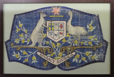
Painting - Acrylic on Canvas, Advance Australia
... Early Wattle Days involved planting wattle trees in school grounds, street decorations of wattle blossom, and wearing sprigs of wattle. ...Early Wattle Days involved planting wattle trees in school grounds, street decorations of wattle blossom, and wearing sprigs of wattle. ...This artwork was found among items associated with the Ballarat School of Mines. Although its purpose remains unknown, it was possibly painted by a staff member or student for use on Wattle Day. Wattle Day originated in October 1889 by the Wattle Blossom League, and was associated with the Australian Natives Association during the lead up to the Federation of Australian States. The first 'national' Wattle Day was celebrated on 1 September 1910. Early Wattle Days involved planting wattle trees in school grounds, street decorations of wattle blossom, and wearing sprigs of wattle. As public support for Wattle Day peaked, World War I broke out. Wattle took on a new significance during the war years, symbolising home for military personnel serving overseas. Beautifully designed Wattle Day badges, as well as wattle sprigs, were sold as a means of raising money for organisations such as the Red Cross. This item is part of the Federation University Art Collection. The Art Collection features over 1000 works and was listed as a 'Ballarat Treasure' in 2007.The Australian coat of arms with wattle, painted onto canvas.art, artwork, emu, kangaroo, crest, advance australia, wattle day, wattle, coat of arms, patriotic, australian coar of arms, national symbol -
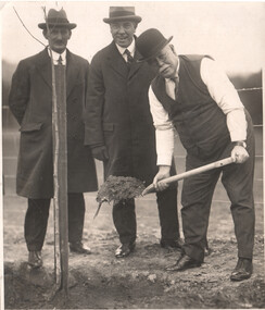 Melbourne Tram Museum
Photograph - MMTB Tree planting - Alex Cameron et al - Wattle Park - set of 3, C J Frazer, 1930s
... MMTB Tree planting - Alex Cameron et al - Wattle Park - set of 3...Wattle Park...Alex Cameron...tree...Set of 3 photos showing a group of four men planting trees at Wattle Park, c1930s with possibly the Chairman's car in the background. ...Demonstrates the work of the MMTB planting trees at Wattle Park and a motor vehicle. tramways Wattle Park Alex Cameron tree planting Stamp of "C J Frazer photographer" on the rear. ...Set of 3 photos showing a group of four men planting trees at Wattle Park, c1930s with possibly the Chairman's car in the background. Alex Cameron, MMTB Chairman is in the bowler hat.Demonstrates the work of the MMTB planting trees at Wattle Park and a motor vehicle.Black and white print - set of 3. Photo 2 has photographer's stamp on the rear.Stamp of "C J Frazer photographer" on the rear.tramways, wattle park, alex cameron, tree planting -
 National Wool Museum
Textile - Cloak, Dr Deanne Gilson, Campfire Gathering, Meeting Place Cloak, 2022
... The circle and diamond pattern are ancient symbols used by Wadawurrung people dating pre-colonisation on possum skin and kangaroo skin cloaks, other artefacts like spear heads (carved), wooden shields, stone tools and caves were painted with blood, ochre and bound with grass tree sap, black wattle tree sap and kangaroo fats. The diamond pattern was a strong design used by men on shields and women on baskets and adornments. ...The circle and diamond pattern are ancient symbols used by Wadawurrung people dating pre-colonisation on possum skin and kangaroo skin cloaks, other artefacts like spear heads (carved), wooden shields, stone tools and caves were painted with blood, ochre and bound with grass tree sap, black wattle tree sap and kangaroo fats. The diamond pattern was a strong design used by men on shields and women on baskets and adornments. ...Standing proud, still here, the spirit of ten ancestral matriarchs adorned in contemporary ceremonial cloaks. Representing our women past, present and future, her Spirit, our culture, our Country (spelt with a capital for its importance and this is part of First Peoples protocols on acknowledging Country, our strength, our resilience and healing towards a sustainable future). The circle and diamond pattern are ancient symbols used by Wadawurrung people dating pre-colonisation on possum skin and kangaroo skin cloaks, other artefacts like spear heads (carved), wooden shields, stone tools and caves were painted with blood, ochre and bound with grass tree sap, black wattle tree sap and kangaroo fats. The diamond pattern was a strong design used by men on shields and women on baskets and adornments. Shields were taken from the tree in the colder months when the tree was cold as the wood came off cleaner. Ochre colours of red, white, yellow and charcoal were often used to colour in and decorate the skin side of possum skin cloaks, wooden shields, spear heads, baskets and some coolamon bowls.The design for this cloak has been simplified from the original artefact design.Cloak with black and white diamond and circle design on outer cloak and coral and white line pattern within lining. Trimming is solid black. Cloak is machine sewn and handstitched with hand stitching on shoulder seam.deanne gilson, wadawurrung, first nations, cloak -
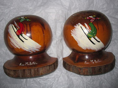 Parks Victoria - Mount Buffalo Chalet
Bookends
... Bookends MBC0319,serviette rings MBC0217.2,eggcup MBC0218 and ashtray MBC0205 made of mulga, a wood from particular types of wattle tree that grow in arid climates. Souvenirs crafted from mulga became popular in the post WW2 years' (Pg 117. ...Bookends MBC0319,serviette rings MBC0217.2,eggcup MBC0218 and ashtray MBC0205 made of mulga, a wood from particular types of wattle tree that grow in arid climates. Souvenirs crafted from mulga became popular in the post WW2 years' (Pg 117. ...Sold as a souvenir of Mt Buffalo. 'Souvenirs in relation to the Chalet and Mount Buffalo were first mention in December 1912... A large range of souvenirs has since been associated with the Chalet and Mount Buffalo from crafted wooden items, silver spoons, cups etc... The collection includes a broad selection of products that have been sold throughout much of the Chalet's history, each representative of the transient fashions of their period.' (Pg. 114. Historica) "Souvenirs in relation to the chalet were perhaps first mentioned in December 1912, when enterprising locals, Mr J Pass of Porepunkah and Mr C Walker asked for permission to use timber on the mountain for making ornamental souvenirs . The government was agreeable to the ide and soon afterwards PWD chief architect George Austin went to Mount buffalo to make arrangements for supply of the timber, They proposed to make wooden egg cups, small boxes and photograph frames to sell to tourists, small items that' will serve as an advertising medium of the famous mount'" (Pg. 113.Historica) ' Fig 123. Bookends MBC0319,serviette rings MBC0217.2,eggcup MBC0218 and ashtray MBC0205 made of mulga, a wood from particular types of wattle tree that grow in arid climates. Souvenirs crafted from mulga became popular in the post WW2 years' (Pg 117. Historica) Purchased in a second hand shop and donated to MBC. Listed in Draft Inventory of Significant Collection Items . Appendix A.3. Souvenirs. (Pg 168. Historica).Two matching mulga wood book ends. They form a sphere when placed together. Hand painted motif and inscription on each. Painting of a skier dressed in colourful clothing on each and "From Mt Buffalo" painted at the base. "From Mt Buffalo" -
 Eltham District Historical Society Inc
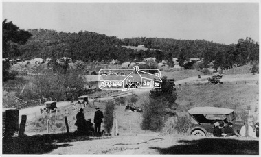
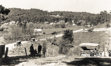
Negative - Photograph, Popular Picnicing at Hurstbridge, c.1925
... It is believed the picture is taken at the northwest corner of the intersection of Wattletree Road and Hurstbridge-Arthurs Creek Road looking southeast towards the township (most likely where the house is located on the property of what is today No. 2 Wattletree Road)- https://goo.gl/maps/VDorwCe1rJJUapjE6 According to a comment by Jean Verso (via @nillumbikcouncil FB page 3 Jan 2020) - "This view is from Wattle Tree Road with Haleys Gully Road to the right and across the creek to William Gray's nursery at Allwood. ...It is believed the picture is taken at the northwest corner of the intersection of Wattletree Road and Hurstbridge-Arthurs Creek Road looking southeast towards the township (most likely where the house is located on the property of what is today No. 2 Wattletree Road)- https://goo.gl/maps/VDorwCe1rJJUapjE6 According to a comment by Jean Verso (via @nillumbikcouncil FB page 3 Jan 2020) - "This view is from Wattle Tree Road with Haleys Gully Road to the right and across the creek to William Gray's nursery at Allwood. ...Picnickers enjoying a Sunday outing near the Wattle Valley Estate at Hurstbridge. Copied from brochure "Wattle Valley Estate". It is believed the picture is taken at the northwest corner of the intersection of Wattletree Road and Hurstbridge-Arthurs Creek Road looking southeast towards the township (most likely where the house is located on the property of what is today No. 2 Wattletree Road)- https://goo.gl/maps/VDorwCe1rJJUapjE6 According to a comment by Jean Verso (via @nillumbikcouncil FB page 3 Jan 2020) - "This view is from Wattle Tree Road with Haleys Gully Road to the right and across the creek to William Gray's nursery at Allwood. The building to the far left looks like Dorset House. The building on the left in the middle distance is still there today and has been used for storage and as a stable/tack room for a number of years." The Wattle Valley Estate was first advertised in August 1925 as weekend building allotments by the Greater Melbourne Land and Development Company. Advertised from £28.10.0 or £60 per block. In August 1926, 30 picked allotments of 60x150 feet were put up for auction Saturday August 14, 1926 with frontages to Valley View Road and Fawkner Crescent advertised in the “Heart of the Glorious Wattle Country” and “Within 15 Minutes of the Newly Electrified Railway Station”. The Advertiser on August 13, 1926 in an article promoting the auction stated “the estate is regarded as one of the best in the district, and will be sold practically without reserve.” It is noted that an advertisement running in The Argus February 22, 1951 offered the remaining 16 blocks for sale at £12.10.0 or £200 the lot. By March 7, the remaining blocks were advertised at £17.10.0 The Wattle Valley Estate took over 20 years to sell and then people could not build on them Cross Ref EDHS_02665 Rose Series Postcard P. 4341, "View at Hurstbridge, Vic." Also, other images from sales brochure SEPP_1055 / 1056This photo forms part of a collection of photographs gathered by the Shire of Eltham for their centenary project book,"Pioneers and Painters: 100 years of the Shire of Eltham" by Alan Marshall (1971). The collection of over 500 images is held in partnership between Eltham District Historical Society and Yarra Plenty Regional Library (Eltham Library) and is now formally known as the 'The Shire of Eltham Pioneers Photograph Collection.' It is significant in being the first community sourced collection representing the places and people of the Shire's first one hundred years.Digital image 4 x 5 inch B&W Neg1925, dorset house, fawkner crescent, haleys gully road, hurstbridge, hurstbridge-arthurs creek road, picnic, postcards, shire of eltham pioneers photograph collection, valley view road, wattle valley estate, wattletree road, exhibition yprl 2019-12 -
 Eltham District Historical Society Inc
Photograph - Postcard, Rose Stereograph Company, View at Hurstbridge, Vic, c.1925
... It is believed the picture is taken at the northwest corner of the intersection of Wattletree Road and Hurstbridge-Arthurs Creek Road looking southeast towards the township (most likely where the house is located on the property of what is today No. 2 Wattletree Road)- https://goo.gl/maps/VDorwCe1rJJUapjE6 According to a comment by Jean Verso (via @nillumbikcouncil FB page 3 Jan 2020) - "This view is from Wattle Tree Road with Haleys Gully Road to the right and across the creek to William Gray's nursery at Allwood. ...It is believed the picture is taken at the northwest corner of the intersection of Wattletree Road and Hurstbridge-Arthurs Creek Road looking southeast towards the township (most likely where the house is located on the property of what is today No. 2 Wattletree Road)- https://goo.gl/maps/VDorwCe1rJJUapjE6 According to a comment by Jean Verso (via @nillumbikcouncil FB page 3 Jan 2020) - "This view is from Wattle Tree Road with Haleys Gully Road to the right and across the creek to William Gray's nursery at Allwood. ...Rose Series Postcard P. 4341 “View at Hurstbridge, Vic.” Picnickers enjoying a Sunday outing near the Wattle Valley Estate at Hurstbridge. Copied from brochure "Wattle Valley Estate". It is believed the picture is taken at the northwest corner of the intersection of Wattletree Road and Hurstbridge-Arthurs Creek Road looking southeast towards the township (most likely where the house is located on the property of what is today No. 2 Wattletree Road)- https://goo.gl/maps/VDorwCe1rJJUapjE6 According to a comment by Jean Verso (via @nillumbikcouncil FB page 3 Jan 2020) - "This view is from Wattle Tree Road with Haleys Gully Road to the right and across the creek to William Gray's nursery at Allwood. The building to the far left looks like Dorset House. The building on the left in the middle distance is still there today and has been used for storage and as a stable/tack room for a number of years." The Wattle Valley Estate was first advertised in August 1925 as weekend building allotments by the Greater Melbourne Land and Development Company. Advertised from £28.10.0 or £60 per block. In August 1926, 30 picked allotments of 60x150 feet were put up for auction Saturday August 14, 1926 with frontages to Valley View Road and Fawkner Crescent advertised in the “Heart of the Glorious Wattle Country” and “Within 15 Minutes of the Newly Electrified Railway Station”. The Advertiser on August 13, 1926 in an article promoting the auction stated “the estate is regarded as one of the best in the district, and will be sold practically without reserve.” It is noted that an advertisement running in The Argus February 22, 1951 offered the remaining 16 blocks for sale at £12.10.0 or £200 the lot. By March 7, the remaining blocks were advertised at £17.10.0 The Wattle Valley Estate took over 20 years to sell and then people could not build on them Cross Ref SEPP_1057, “Popular Picnicing at Hurstbridge” rcopied from Wattle Valley estate sales brochure.Digital file only Postcards scanned from the collection of Michael Aitken on loan to EDHS, 13 Feb 20181925, dorset house, exhibition yprl 2019-12, fawkner crescent, haleys gully road, hurstbridge, hurstbridge-arthurs creek road, michael aitken collection, picnic, postcards, rose stereograph company, shire of eltham pioneers photograph collection, valley view road, wattle valley estate, wattletree road -
 Federation University Historical Collection
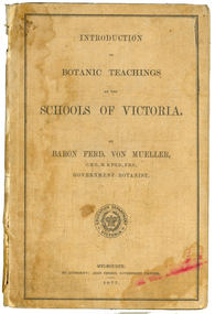
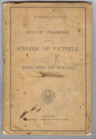
Book, Ferdinand Von Mueller, Introduction to Botanic Teachings at the Schools of Victoria, 1877
... Chapters include Eucalyptus Trees; Wattles or Acacias; Casuarinas or Sheoaks; Cypress Pines or Sandarac trees; Exocarpos trees of Natice Cherry trees; Mistletoes; Native Honeysuckles or Banksias; Bellflower, Lobelia and Goodenia; Heaths; Correas; Mallow; Buttercups and Clematis; Cruciferous Plants; Mints; Orchids; grasses; ferns. ...Chapters include Eucalyptus Trees; Wattles or Acacias; Casuarinas or Sheoaks; Cypress Pines or Sandarac trees; Exocarpos trees of Natice Cherry trees; Mistletoes; Native Honeysuckles or Banksias; Bellflower, Lobelia and Goodenia; Heaths; Correas; Mallow; Buttercups and Clematis; Cruciferous Plants; Mints; Orchids; grasses; ferns. ...Ferdinand von Mueller was an examiner of botany at the Ballarat School of Mines (SMB) between 1880 and 1888. During that era he was active in donating related items to the School. When the Ballarat School of Mines Council agreed to introduce pharmacy and botany classes in 1879, it was apparent students would require access to botanical specimens in order to further their studies. Council members, who were inspired by the work of Baron Ferdinand von Mueller, authorised development of an area along the School's northern boundary, fronting Lydiard Street South, and oversaw the establishment of the new Botanical Gardens. Baron von Mueller took a practical role the development of SMB's Botanical Gardens from the beginning. He became a generous benefactor who 'donated collections of seeds and leguminous fodder plants, including valued grasses of interest and use to agriculturalists and graziers generally' to SMB over many years. Ferdinand von Mueller's entry on the University of Ballarat Honour Roll can be found at http://www.ballarat.edu.au/curator/honour-roll/honourroll_von_mueller.shtml Also See Cat. No. 12062A light brown, hardcovered book of 152 pages. Chapters include Eucalyptus Trees; Wattles or Acacias; Casuarinas or Sheoaks; Cypress Pines or Sandarac trees; Exocarpos trees of Natice Cherry trees; Mistletoes; Native Honeysuckles or Banksias; Bellflower, Lobelia and Goodenia; Heaths; Correas; Mallow; Buttercups and Clematis; Cruciferous Plants; Mints; Orchids; grasses; ferns. The book has numerous botanical line drawings, and a comprehensive index.Inside front cover "Botanist, Teacher, researcher. My you make your mark like the baron. Best wishes for your birthday 1999 Martin"victorian, schools, botany, ferdinand von mueller, von mueller, botanic illustrations, flora, change number -
 Federation University Historical Collection
Book, Ferdinand von Mueller, Introduction to Botanic Teachings at the Schools of Victoria, 1877, 1877 (exact)
... Chapters include Eucalyptus Trees; Wattles or Acacias; Casuarinas or Sheoaks; Cypress Pines or Sandarac trees; Exocarpos trees of Natice Cherry trees; Mistletoes; Native Honeysuckles or Banksias; Bellflower, Lobelia and Goodenia; Heaths; Correas; Mallow; Buttercups and Clematis; Cruciferous Plants; Mints; Orchids; grasses; ferns. ...Chapters include Eucalyptus Trees; Wattles or Acacias; Casuarinas or Sheoaks; Cypress Pines or Sandarac trees; Exocarpos trees of Natice Cherry trees; Mistletoes; Native Honeysuckles or Banksias; Bellflower, Lobelia and Goodenia; Heaths; Correas; Mallow; Buttercups and Clematis; Cruciferous Plants; Mints; Orchids; grasses; ferns. ...Ferdinand von Mueller was an examiner of botany at the Ballarat School of Mines (SMB) between 1880 and 1888. During that era he was active in donating related items to the School. When the Ballarat School of Mines Council agreed to introduce pharmacy and botany classes in 1879, it was apparent students would require access to botanical specimens in order to further their studies. Council members, who were inspired by the work of Baron Ferdinand von Mueller, authorised development of an area along the School's northern boundary, fronting Lydiard Street South, and oversaw the establishment of the new Botanical Gardens. Baron von Mueller took a practical role the development of SMB's Botanical Gardens from the beginning. He became a generous benefactor who 'donated collections of seeds and leguminous fodder plants, including valued grasses of interest and use to agriculturalists and graziers generally' to SMB over many years. Ferdinand von Mueller's entry on the University of Ballarat Honour Roll can be found at http://www.ballarat.edu.au/curator/honour-roll/honourroll_von_mueller.shtml A light brown, hardcovered book of 152 pages. Chapters include Eucalyptus Trees; Wattles or Acacias; Casuarinas or Sheoaks; Cypress Pines or Sandarac trees; Exocarpos trees of Natice Cherry trees; Mistletoes; Native Honeysuckles or Banksias; Bellflower, Lobelia and Goodenia; Heaths; Correas; Mallow; Buttercups and Clematis; Cruciferous Plants; Mints; Orchids; grasses; ferns. The book has numerous botanical line drawings, and a comprehensive index.Inside front cover "J. Clement Souter M.D."victorian, schools, botany, ferdinand von mueller, von mueller, botanic illustrations, j. clement souter -
 Ringwood and District Historical Society
Photograph, North side of City Road, Ringwood 1969
... At that time, it was a narrow rutted dirt road, with a large drain running on the northern side, and a wide nature strip complete with big wattle trees on the southern side, ideal for playing cricket and other games. ...At that time, it was a narrow rutted dirt road, with a large drain running on the northern side, and a wide nature strip complete with big wattle trees on the southern side, ideal for playing cricket and other games. ...Written by Michael Anderson on RDHS Facebook on March 2016 CITY ROAD, RINGWOOD 1959 My family moved to City Road in 1959. At that time, it was a narrow rutted dirt road, with a large drain running on the northern side, and a wide nature strip complete with big wattle trees on the southern side, ideal for playing cricket and other games. There was no Salvation Army Citadel, nor was there a Lutheran Church. As you proceed from Wantirna Road towards Jubilee Park, there were no houses on the right hand side at all until you reached our house, 14 City Road, which at the time was Lot 51. On the corner where the Lutheran Church now stands, there was an old rusty farm gate, attached to a very weathered wooden post. This indicated that at some stage, City Road had been a private road. This rusty old gate was never closed, but it was a remnant of bygone days. Ireland St, Regina St, and Greenwood Avenue south of Haig Street were all narrow dirt roads as well. Jubilee Park Oval was fairly new, and there was no grandstand. The players and staff had to make do with a small wooden building that looked like a garden shed. Just beyond the southern end of the oval were growing many wild pumpkins, and I understand that the land had been a rubbish tip in the not so distant past. The park also had a couple of tennis courts. There was no road from Jubilee Park to Reilly St, and Reilly St didn't go all the way through from Wantirna Road to Great Ryrie St. It was broken by a creek. Aquinas College was an orchard. As you proceed up City Road from Wantirna Road, The Salvation Army church is on the left corner. The Hobbs family lived on that corner, in an old house on a block which was bordered by a huge hedge. The house next door in Wantirna Road, which is also Salvation Army land now, was owned by the Bayliss family. Mrs Bayliss was a teacher at Ringwood High. The first house in City Rd proper was at no. 1 to 5. The Roberts family lived there in an old weatherboard house on an acre of land. Mr Roberts was a carpenter who had built our house at No. 14, and he lived there with his wife and two sons, Graeme and Max. Eventually, they wanted more space, so they moved to the acre. Next door to the Roberts was Ted O'Regan at no. 7 to no. 9. He appears to have been a widower, and he lived by himself in an old wooden house which was surrounded by a large veranda on about 2/3 acre. Next door to Ted O'Regan lived his brother Jack O'Regan at no. 11 on about 1/2 acre, with his wife Edna, his son Alan, and his Daughter Judith. Barney Meadows lived on about 1/2 acre at no. 13. Barney was an old widower, and his front garden had a huge palm tree in it. Next to Barney lived the Reeves at no. 15, and finally there was the McDonald family at no. 17, which is on the corner of Regina St. From then on, City Rd, was a bush block down to Greenwood Ave, and the bush continued up Greenwood Ave to the Williams house, one house block from Haig St. On the right hand side of City Road it was all paddock to Ireland St, and another paddock which ended at our house was over the other side of Ireland St. Both paddocks were developed in about 1961/62, and there are about 12 houses there now, plus the Lutheran Church. When we first moved there, there was a horse and a cow grazing in the paddock beside our house. For the first couple of years, there was a huge bonfire in "our" paddock to mark Guy Fawkes day. It was a lot of fun, although I concede that it might have been a tad dangerous, with 3d. bungers and all that! Next door to us at no. 16 was the Goessling family. From now on the house blocks were normal sized. The Goesslings had one baby girl who was about 9 months old when we first moved in, but they ended up with 4 kids, all of whom would be middle aged now. They were observant Lutherans, but they were there before the church. Next door to the Goesslings at no. 18 was the Weir family on the corner of Regina St. On the other side of Regina St. at no. 20 was the Gowland family, and the last house in the street at no. 22 was owned by Arthur Johnston and his family. Arthur was an Ambulance Driver. Of course, many other people moved in and moved out in all those years. There was one particularly bad week for the street in June 1969. My brother Peter was killed in a work accident on Saturday 7th June. The next Wednesday 11th June Ted O'Regan, who lived diagonally opposite us died. Then on the next Saturday the 14th June, Ted Bell, who lived next door to us at no. 12 died from a heart attack at the age of 47. Three deaths in one week was a bit too much. It was eerie! Our old house is still standing, but I doubt for much longer. It was bought by people who wanted to develop it. Their plans were knocked back, so they sold it again. I would bet that in the not too distant future the house will be a piece of history. City Road was a paradise for kids when we moved in. We had lived in the inner suburbs, so the space and freedom were amazing for us "city slickers." I don't know where you could move to now if you wanted to bring up your children in a similar environment. Somehow, I don't think it would be possible. -
 Ringwood and District Historical Society
Photograph, City Road – North Side. Owned by E A (Ted) O’Regan on 23 March 1969
... At that time, it was a narrow rutted dirt road, with a large drain running on the northern side, and a wide nature strip complete with big wattle trees on the southern side, ideal for playing cricket and other games. ...At that time, it was a narrow rutted dirt road, with a large drain running on the northern side, and a wide nature strip complete with big wattle trees on the southern side, ideal for playing cricket and other games. ...Written by Michael Anderson on RDHS Facebook on March 2016 CITY ROAD, RINGWOOD 1959 My family moved to City Road in 1959. At that time, it was a narrow rutted dirt road, with a large drain running on the northern side, and a wide nature strip complete with big wattle trees on the southern side, ideal for playing cricket and other games. There was no Salvation Army Citadel, nor was there a Lutheran Church. As you proceed from Wantirna Road towards Jubilee Park, there were no houses on the right hand side at all until you reached our house, 14 City Road, which at the time was Lot 51. On the corner where the Lutheran Church now stands, there was an old rusty farm gate, attached to a very weathered wooden post. This indicated that at some stage, City Road had been a private road. This rusty old gate was never closed, but it was a remnant of bygone days. Ireland St, Regina St, and Greenwood Avenue south of Haig Street were all narrow dirt roads as well. Jubilee Park Oval was fairly new, and there was no grandstand. The players and staff had to make do with a small wooden building that looked like a garden shed. Just beyond the southern end of the oval were growing many wild pumpkins, and I understand that the land had been a rubbish tip in the not so distant past. The park also had a couple of tennis courts. There was no road from Jubilee Park to Reilly St, and Reilly St didn't go all the way through from Wantirna Road to Great Ryrie St. It was broken by a creek. Aquinas College was an orchard. As you proceed up City Road from Wantirna Road, The Salvation Army church is on the left corner. The Hobbs family lived on that corner, in an old house on a block which was bordered by a huge hedge. The house next door in Wantirna Road, which is also Salvation Army land now, was owned by the Bayliss family. Mrs Bayliss was a teacher at Ringwood High. The first house in City Rd proper was at no. 1 to 5. The Roberts family lived there in an old weatherboard house on an acre of land. Mr Roberts was a carpenter who had built our house at No. 14, and he lived there with his wife and two sons, Graeme and Max. Eventually, they wanted more space, so they moved to the acre. Next door to the Roberts was Ted O'Regan at no. 7 to no. 9. He appears to have been a widower, and he lived by himself in an old wooden house which was surrounded by a large veranda on about 2/3 acre. Next door to Ted O'Regan lived his brother Jack O'Regan at no. 11 on about 1/2 acre, with his wife Edna, his son Alan, and his Daughter Judith. Barney Meadows lived on about 1/2 acre at no. 13. Barney was an old widower, and his front garden had a huge palm tree in it. Next to Barney lived the Reeves at no. 15, and finally there was the McDonald family at no. 17, which is on the corner of Regina St. From then on, City Rd, was a bush block down to Greenwood Ave, and the bush continued up Greenwood Ave to the Williams house, one house block from Haig St. On the right hand side of City Road it was all paddock to Ireland St, and another paddock which ended at our house was over the other side of Ireland St. Both paddocks were developed in about 1961/62, and there are about 12 houses there now, plus the Lutheran Church. When we first moved there, there was a horse and a cow grazing in the paddock beside our house. For the first couple of years, there was a huge bonfire in "our" paddock to mark Guy Fawkes day. It was a lot of fun, although I concede that it might have been a tad dangerous, with 3d. bungers and all that! Next door to us at no. 16 was the Goessling family. From now on the house blocks were normal sized. The Goesslings had one baby girl who was about 9 months old when we first moved in, but they ended up with 4 kids, all of whom would be middle aged now. They were observant Lutherans, but they were there before the church. Next door to the Goesslings at no. 18 was the Weir family on the corner of Regina St. On the other side of Regina St. at no. 20 was the Gowland family, and the last house in the street at no. 22 was owned by Arthur Johnston and his family. Arthur was an Ambulance Driver. Of course, many other people moved in and moved out in all those years. There was one particularly bad week for the street in June 1969. My brother Peter was killed in a work accident on Saturday 7th June. The next Wednesday 11th June Ted O'Regan, who lived diagonally opposite us died. Then on the next Saturday the 14th June, Ted Bell, who lived next door to us at no. 12 died from a heart attack at the age of 47. Three deaths in one week was a bit too much. It was eerie! Our old house is still standing, but I doubt for much longer. It was bought by people who wanted to develop it. Their plans were knocked back, so they sold it again. I would bet that in the not too distant future the house will be a piece of history. City Road was a paradise for kids when we moved in. We had lived in the inner suburbs, so the space and freedom were amazing for us "city slickers." I don't know where you could move to now if you wanted to bring up your children in a similar environment. Somehow, I don't think it would be possible. -
 Eltham District Historical Society Inc
Photograph, Tess Justine (Nillumbik Shire Council), Murray's Bridge over the Diamond Creek, Eltham North, 19 Feb 2022
... Flood damage was ongoing, and even more recently constructed raised bridges kept getting washed away, e.g., the new Wattle Tree Road bridge in 1958 just months after completion. ...Flood damage was ongoing, and even more recently constructed raised bridges kept getting washed away, e.g., the new Wattle Tree Road bridge in 1958 just months after completion. ...Murray's Bridge over the Diamond Creek on the Diamond Creek Trail just prior to demolition and replacement with a new steel bridge. Heritage advice obtained by Nillumbik Shire Council, following a suggestion by the Eltham District Historical Society (EDHS), is that the original bridge appears to have been a simplified version of the Country Roads Board’s (CRB) standard timber bridge design of the early-to-mid 1920s. In c1990 Murray’s bridge was renovated with three recycled steel girders as part of a bike/pedestrian path in the reserve. During these alterations many parts of the bridge were removed, and some were replaced. Heritage advice indicates the condition of Murray’s bridge is poor. The remaining original parts are all in poor condition, with severe weathering, splitting and rot, especially to the stringers retained on the bridge. Heritage advice is that Murray’s Bridge does not have sufficient significance in the cultural history of the Nillumbik area to warrant inclusion in the Nillumbik Shire Heritage Overlay and also does not have sufficient significance as a rare survivor to warrant inclusion in the Nillumbik Shire Heritage Overlay. There are no indications in the historical record that this site was individually important to the cultural history of this area. EDHS is comfortable with the heritage advice provided to Council and has worked closely on this project with Council. EDHS has suggested some of the removed timbers be used in the vicinity of the bridge for landscaping and possibly seating, so as to retain these remnants close to the site of the original bridge, which is the last old timber bridge along the lower reaches of the Diamond Creek. Mary (Sweeney) Murray and John Wright Murray selected 80 acres, Lot C Section 16 and Lot 5 Section 17 Parish of Nillumbik, under an occupation license in 1866. John died in 1867 and freehold was granted to his son John in 1873. The farm was known as ‘Laurel Hill’. John Junior was an Eltham Shire councillor and sometime president from 1887 up until 1897. He added Lot A Section 16 to the farm in ca1888. John and his younger brother James arranged to rent/purchase Lot B Section 17, across Diamond Creek to the west, in ca1900. It appears that John and James farmed separately for a few years, with a new homestead built for James ad family on the high point of Lot B Section 17 in ca1910. John sold off Lot 5 Section 17 in 1912. When John died in 1912 James took over the land on both sides of the Diamond Creek. The old homestead on the west side of the Creek disappeared. A farm bridge over Diamond Creek from this period may have been located close to the northern boundary of the farm. John Langlands, owner of the farm known as ‘Ihurst’ on the west side of Diamond Creek to the south of the Murray’s land, died in 1907. In 1909 his land was then subdivided into 100 lots to become the ‘Glen Park Estate’. Other similar subdivisions of nineteenth century farms around Eltham in this period included the ‘Franktonia (or Beard’s) Estate’ to the northeast and ‘Bonsack’s Estate’ between Eltham and Greensborough. Soon after the opening of the railway extension line from Eltham to Hurstbridge in 1912, Glen Park and nearby residents including James Murray agitated for a railway station or siding to be located half-way between Eltham and Hurstbridge, so that the Glen Park residents who used the railway daily did not have to walk into the Eltham or Hurstbridge stations. Some believed Coleman’s Corner (opposite Edendale Farm) was an appropriate spot for the platform. James Murray was among those who thought the railway should be located on his land, closer to half-way between Eltham and Hurstbridge stations. The Railways Commissioners warned that the locals would have to fund these works themselves. The Glen Park Estate residents initially had difficulty accessing Eltham by road, with only an old low-level bridge over Diamond Creek at the south end of their estate. A new timber trestle bridge across the creek, now on Wattletree Road, was opened in 1915. Road access to the north was gained in 1927 when the new Murray’s Road, which crossed the Murray’s land, was built. Residents continued to agitate for a Glen Park station. By 1926 the Railways Commissioners’ preferred site was on the Murray’s land. They arranged an estimate of cost of a full-length platform. The estimate was too much for the locals, who in 1928 argued unsuccessfully for a shorter and hence cheaper platform. By 1929 Murray had agreed to donate the land, but the locals would still have to fund the works. Murray decided, unilaterally it would appear, to commence work on a timber trestle road bridge over Diamond Creek to link the new Murray Road to the proposed station. Late in 1929 he stopped work on the bridge, for reasons unknown, but started work again and completed the bridge in 1931. There is no further newspaper evidence of the campaign for the Glen Park station until 1939, when Murray and another local, Mr Maxwell, met the Railways Commissioner. The Glen Park locale now included 45 homes on the west side of the creek and 20 on the Eltham side. Most of the residents used the train every day. The Commissioner remained adamant that only a full-length platform could be built for safety reasons. It appears the campaign dissolved at this point. The increasing move to cars may have had an impact. There is no evidence of Murray’s bridge ever being connected to Murray’s Road, or of it having wide use for any purpose by locals. James Murray died in 1947 and the farm was taken over by his son James (Jim). Jim started to sell off parts of the farm in the 1980s, retaining a few acres around the ca1910 homestead and building a new house there. Recreation reserves were established along the creek. In ca1990 Murray’s bridge was renovated with steel girders as part of a bike/pedestrian path in the reserve. The old farmhouse was demolished in ca2014. * * * A theory posted on local community Facebook groups was that the bridge was built in the 1860s and was built to be more robust than was necessary for the movement of cows from one side of the creek to the other. It was suggested the robustness was necessary to support the weight of gold ore being transferred from a mine on Murray’s land to a railway siding near Murrays Bridge (presumably for transfer and processing at Diamond Creek). Perhaps this may have been one of the motivators for Murray, who really knows? Knowing when mining operations ceased on his land and how that fits the overall timeline would be useful but at the time the bridge was built, local gold production was minimal at best. The known facts are: • The railway line came to Eltham in 1902. • The extension of the railway from Eltham to Hurstbridge was constructed in 1912 so no railway line even existed through Murray's property until 1912 and the Victorian Railways maps at the time show no such siding on Murray’s property. • In 1923 a new company was formed in anticipation of the old Diamond Creek Gold Mine being re-opened. The mine had been previously closed and flooded. It was noted in the press at the time that the mine was within a mile of the railway. Nothing really came of this. • Construction of Murrays Bridge was commenced by James Murray in early 1929 in anticipation of a proposed flag station being nominated on his land, but work ceased shortly afterwards. The proposed flag station was commonly referred to as Glen Park as the residents of the Glen Park Estate wanted Option 1, located near them with the platform adjacent to Colemans corner. This was probably never going to fly as it was virtually in eyesight of Eltham station. Allandale Road was the third option, but the Commissioners' preferred option was No. 2 - on Murray's property. • The Railway Commissioners were not going to finance any such station and the works had to be funded by private landowners and residents, hence Murray investing in this himself. • Murray recommenced work two years later and finished his bridge in 1931 but unfortunately for him, the proposed flag station never eventuated. The bluestone siding you reference may well have been built by Murray as part of the proposed station platform. • Up until then, apart from the Main Road bridge, which was washed away in 1924, virtually all local crossings over the Diamond Creek were low lying bridges – Kaylocks Bridge at Brougham Street, Diamond Street bridge, Glen Park Road bridge. It is expected that Murray also had a low-lying bridge to connect his land either side of the creek. These were all washed away or severely damaged multiple times in the 1920s. Lessons were learnt, and Murrays Bridge appears to have been built in accordance with Country Road Board standards of the time. Flood damage was ongoing, and even more recently constructed raised bridges kept getting washed away, e.g., the new Wattle Tree Road bridge in 1958 just months after completion. Murray’s bridge was reinforced with steel some 30 years ago presumably to provide additional floodwater resistance, given the history of bridges disappearing in floodwaters. • In March 1932 it was reported in the Advertiser that there were still some prospectors operating around Eltham North who apart from further scarring the face of the earth over the previous two years had gained significant experience but little gold - hardly a driving factor for constructing a dedicated railway siding and bridge to transfer gold ore. It is far more probable that James Murray was hoping to have the railway station located on his property and invested his money by building the bridge to lead to it as well as a station platform. Had the station eventuated, it may well have driven up the value of his land for subdivision and new housing estates like the Glen Park Estate. That did not eventuate. Whilst the bridge was indeed old (90 years), the core structure being completed in 1931, it had been modified substantially from original and hence had no significant historic value – i.e., it was not a representative example of its type, construction, and age. Given that the bridge was not worthy of saving, the Eltham District Historical Society with Council’s support, and the Eltham Woodworkers group endeavoured to see what suitable sized timbers were salvageable to fabricate a commemorative seat. Unfortunately, the experts at the Woodworkers group were unable to salvage any suitable length/width timbers to fabricate the seat due to the presence of rot. Last remaining wooden trestle bridge on the Diamond Creek Trail just prior to demolition and replacementBorn digital image (27)diamond creek (creek), diamond creek trail, murrays bridge, ‘laurel hill’, john wright murray, mary (sweeney) murra, john murray jnr, james murray, john langlands, ‘ihurst’, ‘glen park estate’, beard's estate, franktonia, bonsack's estate, glen park estate, glen park railway station -
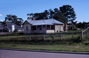
 Eltham District Historical Society Inc
Book, Percy Leason: an artist's life by Margot Tasca, 2016
... The front lawn was taken over by onion grass (or wiregrass as Leason called it) and scattered about the property were many wattles and gum trees. Aloe cacti covered much to the front of the house, while old quince and lucerne hedges separated the house and out-buildings from a rundown apple orchard. ...The front lawn was taken over by onion grass (or wiregrass as Leason called it) and scattered about the property were many wattles and gum trees. Aloe cacti covered much to the front of the house, while old quince and lucerne hedges separated the house and out-buildings from a rundown apple orchard. ..."Who would have thought that a boy born in 1889 from the Victorian Mallee would become a successful artist on New York’s Staten Island? This finely illustrated, exhaustively researched and beautifully written biography on Leason features the artist’s entire career as a painter and cartoonist renowned for his depictions of Australian society in the 1920s and 1930s. Leason’s story is a poignant one tracing his beginnings as a cartoonist, to the bohemian Melbourne art scene in the early 20th century, to his involvement in the artists’ camps of Eltham, to his important series of portraits of Lake Tyers Indigenous Australians, and his eventual move to the US where he has been acknowledged as making an enormous contribution to the New York arts scene. This story, as yet untold, fills a gap in the history of art in Australia and offers a new perspective on Australian art in the first half of the 20th century." - Thames and Hudson website A NEW HOME IN ELTHAM Once they had settled back into Melbourne, Perry and Belle began to look for a place to make a permanent home. Having enjoyed the bush setting of Mosman, they decided to explore the rural fringes of Melbourne. Each weekend they packed a picnic and travelled to the towns in the nearby hills - such as Ferntree Gully, Sassafras, Lilydale and, of course, Cockatoo Creek. Eventually deciding these places might be a little too far from The Herald office, they searched closer to the city. The Heidelberg and Box Hill regions that had inspired his old teacher McCubbin, had become busy, urban areas but further east, towards Warrandyte and Templestowe, there were still large tracts of bush. Finally they settled on Eltham, an area Percy knew very well, having often painted there with Jock Frater. Perry's old friend Dick McCann and his wife Margery had also settled in Eltham. The township was fifteen miles from Melbourne and serviced by an electric train that went to the central Melbourne station of Flinders Street, near where The Herald offices were located. Eltham was a small village in 1925, separated from Melbourne by the Yarra River, and surrounded by orchards and large tracts of bush. Small farms dotted the landscape and the main businesses revolved around ironmongers, blacksmiths, and farming supplies. Of particular appeal to artists was Eltham Park, a large expanse of bushland bounded by the Yarra River on the south side and the Diamond Creek on the east. The park included a playing field that was busy on weekends with cricket or football matches, but for the rest of the week it was mostly empty and an ideal place to paint. The scenery there provided the inspiration for many paintings by Leason, Meldrum and other artists such as Colin Colahan and Peter (A.E.) Newburv. The Leasons found a rundown old farmhouse on four-and-a-half acres of land in New Street, now known as Lavender Park Road. The site was splendid, at the top of a gentle slope which gave panoramic views east to the Dandenong hills, south over the Templestowe orchards and north to Kinglake. The front lawn was taken over by onion grass (or wiregrass as Leason called it) and scattered about the property were many wattles and gum trees. Aloe cacti covered much to the front of the house, while old quince and lucerne hedges separated the house and out-buildings from a rundown apple orchard. Here they would build a new home. ·with financial assistance from The Herald, Leason bought the property and immediately commissioned an architectural firm to design a new house in the popular bungalow style of the time. The old farm house was demolished but Percy saved the siding boards, bricks and corrugated iron for the outbuildings of his new home. The new house was a two storey, triple brick with a large, gabled, terracotta tiled roof. It was situated at the very top of the slope. The paint and varnish were barely dry when the family moved in during the summer of 1925-26 and the fumes were overpowering in the heat. Despite the house being wired for electricity, power poles had not yet reached the area and initially the family had to rely on kerosene lamps and candles. When electricity did arrive, Leason reflected on the community's reception of electricity at the expense of the old growth gum tree corridors in his cartoon, Electricity comes to Wiregrass. The family had now grown to seven. Jack was nearly nine, Jean was seven, Marjory was four, Nancy was two and the baby Patricia was seven months old. Jack and Jean were enrolled in the local primary school down the hill. A retired farmer, Jock McMillan, came to live on the property and help out with the general maintenance. Jock built himself a shack and Belle provided him with meals. He was kept occupied building structures around the property·, such as the garage, the outside toilet, garden beds, trellis arbours and a number of ponds. The elderly, bearded Scotsman with his old hat and baggy pants also provided the inspiration for one of the characters Leason regularly included in his cartoons. Like Leason, Jock smoked a straight stemmed pipe. A neighbour was employed to help Belle with domestic chores, and so the family settled down to live comfortably in their new Eltham house. Two dogs, Maginary and Wodger, completed the large and vibrant household. “Percy Leason; an artist’s life” by Margot Tasca, Thames & Hudson Australia Pty Ltd, Port Melbourne 2016, pp 63-64 Hardback Bookpercy leason, margot tasca, biography, artist, landscape