Showing 7 items matching "weather radar system"
-
 Moorabbin Air Museum
Manual (Item) - Bendix King Installation Manual Bendix RDS 86 Colour/Color Weather Radar System
... Bendix King Installation Manual Bendix RDS 86 Colour/Color Weather Radar System...Bendix King Installation Manual Bendix RDS 86 Colour/Color Weather Radar System...Moorabbin Air Museum Moorabbin Airport 12 First Street Moorabbin melbourne Bendix King Installation Manual Bendix RDS 86 Colour/Color Weather Radar System Manual Bendix King Installation Manual Bendix RDS 86 Colour/Color Weather Radar System ... -
Moorabbin Air Museum
Manual (Item) - RCA AVQ-30X Weather Radar, RCA AVQ-30X Weather Radar System Specification 1711272
... RCA AVQ-30X Weather Radar System Specification 1711272...Moorabbin Air Museum Moorabbin Airport 12 First Street Moorabbin melbourne RAC Aviation Equipment Dept RCA AVQ-30X Weather Radar System Specification 1711272 Manual RCA AVQ-30X Weather Radar ...RAC Aviation Equipment Dept -
Moorabbin Air Museum
Manual (Item) - RCA AVQ-21 Weather Radar Pilot's Hanbook, Pilot's Handbook AVQ-21 Weather Radar System
... Pilot's Handbook AVQ-21 Weather Radar System...Moorabbin Air Museum Moorabbin Airport 12 First Street Moorabbin melbourne RCA Aviation Equipment Dept Pilot's Handbook AVQ-21 Weather Radar System Manual RCA AVQ-21 Weather Radar Pilot's Hanbook ...RCA Aviation Equipment Dept -
Moorabbin Air Museum
Manual - Lockheed Hercules technical training, Customer Training Electronics
... ...Weather radar system...Moorabbin Air Museum Moorabbin Airport 12 First Street Moorabbin melbourne Lockheed Hercules technical training Equipment installation Gables intercommunication system Voice recorders Flight recorders Emergency transmitter HF/VHF Distance measuring equipment Beacon Transponder Altimeter Weather radar system Flight director system Magnetic compass Autopilot Doppler radar Technical overview of Hercules electronics systems, circa 1976 Customer Training Electronics Manual Lockheed Hercules technical training ...Technical overview of Hercules electronics systems, circa 1976non-fictionTechnical overview of Hercules electronics systems, circa 1976equipment installation, gables intercommunication system, voice recorders, flight recorders, emergency transmitter, hf/vhf, distance measuring equipment, beacon, transponder, altimeter, weather radar system, flight director system, magnetic compass, autopilot, doppler radar -
 Running Rabbits Military Museum operated by the Upwey Belgrave RSL Sub Branch
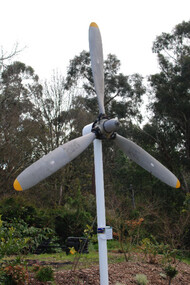
Propeller for a DHC-4 Caribou light transport
... System (LAPES), where up to 2000kg of sled-mounted cargo is extracted from the aircraft by a parachute from a metre above the ground. The Caribou is equipped with GPS satellite navigation and night-vision equipment, giving it the capability to operate in any weather, day or night, to either land or drop soldiers and equipment by parachute with pinpoint accuracy. The Caribou is not pressurised and is not fitted with auto-pilot or weather radar ...DHC-4 Caribou light transport The Royal Australian Air Force DHC-4 Caribou was a versatile tactical light transport aircraft . Its main operational role was tactical air transport in support of the Australian Army. The Caribou was last operated by No 38 Squadron from RAAF Base Townsville in December 2009. The Caribou is a twin-engined high-wing monoplane with full-span double-slotted Fowler flaps and fully-reversible propellers, which allow it to achieve its trademark steep approach with very short take-offs and landings on unprepared runways. The high wing and distinctive high placement of the tail provide easy access to a large cargo compartment, while the low-pressure tyres permit operation on unprepared runways. It was the last piston-engined aircraft in the Air Force and was our only aircraft to employ the Low Altitude Parachute Extraction System (LAPES), where up to 2000kg of sled-mounted cargo is extracted from the aircraft by a parachute from a metre above the ground. The Caribou is equipped with GPS satellite navigation and night-vision equipment, giving it the capability to operate in any weather, day or night, to either land or drop soldiers and equipment by parachute with pinpoint accuracy. The Caribou is not pressurised and is not fitted with auto-pilot or weather radar. The first Caribou arrived in Australia in April 1964 and they were deployed to Vietnam from July 1964 to February 1972 and carried over 600,000 passengers and a huge quantity of cargo while they were there. Since 1997 the Caribou participated in famine-relief operations in Papua New Guinea and Irian Jaya during Operations SIERRA, PLES DRAI and AUSINDO JAYA, as well as the tsunami-relief operation in PNG in 1999 and operations in East Timor and the Solomon Islands since 1999. Their service life was over 40 years. raaf caribou aircraft -
Moorabbin Air Museum
Manual (Item) - AVQ-55 Weather Radar
... Northrop Aeronautical Institute Aircraft Maintenance and Repair & General Systems Description Book Level of Importance: World. Manual AVQ-55 Weather Radar ...Description: 444 pages. Published by Northrop Aeronautics & McGraw-Hill. Published 1955. Northrop Aeronautical Institute Aircraft Maintenance and Repair & General Systems Description Book Level of Importance: World. -
 Department of Energy, Environment and Climate Action
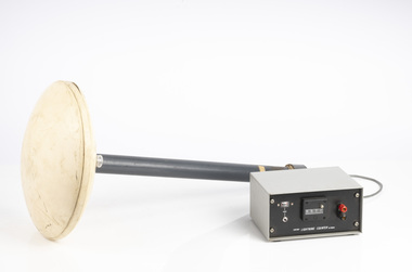
Lightning Detector
... The systems calculate the lightning's location and speed by measuring how long it takes for the radio signal to reach the different antenna stations. The BOM also has a Thunderstorm Tracker that uses weather radar...The systems calculate the lightning's location and speed by measuring how long it takes for the radio signal to reach the different antenna stations. The BOM also has a Thunderstorm Tracker that uses weather radar ...Lightning is one of the major causes of bushfires, particularly in the remote mountains. This lightning detector system was developed by Dr. Peter Kourtz at Canada’s forest fire research institute. By 1977, some 300 were in use across the country. The small mushroom antenna could detect short-range (20-mile) changes in electrostatic field associated with lightning strikes. It needed to be placed out in the open on a hilltop and away from nearby trees. It simply counted the number of "strikes". The detector doesn't seem to have a direction finding capability or be able to distinguish between cloud-to-cloud or cloud-to-ground lightning. It's not sure how this particular unit found its way to Victoria. The Bureau of Meteorology's (BOM) current lightning detector network uses radio waves emitted by lightning to pinpoint the location of lightning strikes. The network is operated by a private company that sends data to the BOM in real time. Lightning detection systems use sensors like antennas, GPS receivers, and processing systems to detect radio waves, also known as sferics. The systems calculate the lightning's location and speed by measuring how long it takes for the radio signal to reach the different antenna stations. The BOM also has a Thunderstorm Tracker that uses weather radar data to identify areas of potential thunderstorm activity. The tracker updates every six minutes and shows the direction thunderstorms are moving, as well as their expected position in 10, 20, and 30 minutesLightning detector 1970sQ-Techforests commission victoria (fcv), weather, bushfire, bushfire aviation