Showing 14 items matching "weidlich road"
-
 Greensborough Historical Society
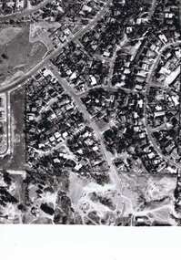
Photograph - Digital image, Frank Solomon, Pig Farm, Weidlich Road area: aerial view, 02/08/2009
... Pig Farm, Weidlich Road area: aerial view......weidlich road greensborough...An aerial view of the pig farm in Weidlich Road Greensborough, owned by Werner Hanusch. ...Greensborough Historical Society 34A Glenauburn Road Lower Plenty Lower Plenty melbourne An aerial view of the pig farm in Weidlich Road Greensborough, owned by Werner Hanusch. ...An aerial view of the pig farm in Weidlich Road Greensborough, owned by Werner Hanusch. The land was used as a pig farm and quarry from 1954 and has now been subdivided into the Evelyn Way estate. This project of fifty, one double storey, dwellings was commenced on 2/8/2009 and completed on 6/2/2011.An example of the changing land use in Greensborough, from farming to residential.Digital copy of aerial photographwerner otto fritz hanusch, pig farm st helena, weidlich road greensborough, one evelyn way greensborough -
 Greensborough Historical Society
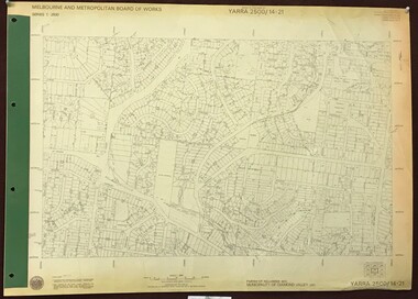
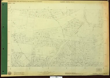
Map, Melbourne and Metropolitan Board of Works. Survey Division, MMBW, Yarra 2500 / 14.21. St Helena, Weidlich Road, 1979_08
... MMBW, Yarra 2500 / 14.21. St Helena, Weidlich Road....Prominent streets St Helena Road, Weidlich Road, Karingal Drive and Progress Road. ...Prominent streets St Helena Road, Weidlich Road, Karingal Drive and Progress Road. ...Melbourne and Metropolitan Board of Works. Yarra 2500 [base map] 14.21. St Helena, Weidlich Road. Parish of Nillumbik 3310. Municipality of Diamond Valley 257. Prominent streets St Helena Road, Weidlich Road, Karingal Drive and Progress Road. Features include the Blair Reserve.MMBW Map in 1:2500 [scale] series. Cream parchment with green tape reinforcing on edges and punched holes on left edge.mmbw, melbourne and metropolitan board of works, shire of diamond valley, st helena - maps -
 Greensborough Historical Society
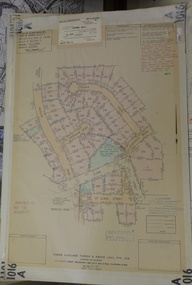
Planning Document, Subdivision Plan # 1016. Corner Weidlich and St Clems Roads Greensborough, 05/10/1981
... ...weidlich road...Plan of Subdivision of land at corner of Weidlich Road and St Clems Road Greensborough....Greensborough Historical Society 34A Glenauburn Road Lower Plenty Lower Plenty melbourne Plan of Subdivision of land at corner of Weidlich Road and St Clems Road Greensborough. subdivision plans weidlich road Stamped and handwritten Council permissions, dates and other details. ...Plan of Subdivision of land at corner of Weidlich Road and St Clems Road Greensborough.Plan (2 sheets) mounted on heavy card.Stamped and handwritten Council permissions, dates and other details.subdivision plans, weidlich road -
 Greensborough Historical Society
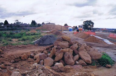
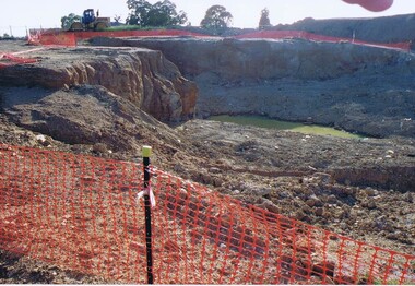
Photograph - Digital image, Frank Solomon, Development of pig farm to residential blocks, 1, 02/08/2009
... ...weidlich road greensborough...A view of the redevelopment of the pig farm in Weidlich Road Greensborough, owned by Werner Hanusch. ...Greensborough Historical Society 34A Glenauburn Road Lower Plenty Lower Plenty melbourne A view of the redevelopment of the pig farm in Weidlich Road Greensborough, owned by Werner Hanusch. ...A view of the redevelopment of the pig farm in Weidlich Road Greensborough, owned by Werner Hanusch. The land was used as a pig farm and quarry from 1954 and this photo shows early stages of the land being subdivided into the Evelyn Way estate. This project of fifty, one double storey, dwellings was commenced on 2/8/2009 and completed on 6/2/2011.An example of the changing land use in Greensborough, from farming to residential.Digital copy of colour photographwerner otto fritz hanusch, pig farm st helena, weidlich road greensborough, one evelyn way greensborough -
 Greensborough Historical Society
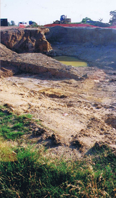
Photograph - Digital image, Frank Solomon, Development of pig farm to residential blocks, 2, 02/08/2009
... ...weidlich road greensborough...A view of the redevelopment of the pig farm in Weidlich Road Greensborough, owned by Werner Hanusch. ...Greensborough Historical Society 34A Glenauburn Road Lower Plenty Lower Plenty melbourne A view of the redevelopment of the pig farm in Weidlich Road Greensborough, owned by Werner Hanusch. ...A view of the redevelopment of the pig farm in Weidlich Road Greensborough, owned by Werner Hanusch. The land was used as a pig farm and quarry from 1954 and this photo shows early stages of the land being subdivided into the Evelyn Way estate. This project of fifty, one double storey, dwellings was commenced on 2/8/2009 and completed on 6/2/2011.An example of the changing land use in Greensborough, from farming to residential.Digital copy of colour photographwerner otto fritz hanusch, pig farm st helena, weidlich road greensborough, one evelyn way greensborough -
 Greensborough Historical Society
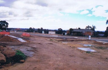
Photograph - Digital image, Frank Solomon, Development of pig farm to residential blocks, 3, 02/08/2009
... ...weidlich road greensborough...A view of the redevelopment of the pig farm in Weidlich Road Greensborough, owned by Werner Hanusch. ...Greensborough Historical Society 34A Glenauburn Road Lower Plenty Lower Plenty melbourne A view of the redevelopment of the pig farm in Weidlich Road Greensborough, owned by Werner Hanusch. ...A view of the redevelopment of the pig farm in Weidlich Road Greensborough, owned by Werner Hanusch. The land was used as a pig farm and quarry from 1954 and this photo shows early stages of the land being subdivided into the Evelyn Way estate. This project of fifty, one double storey, dwellings was commenced on 2/8/2009 and completed on 6/2/2011.An example of the changing land use in Greensborough, from farming to residential.Digital copy of colour photographwerner otto fritz hanusch, pig farm st helena, weidlich road greensborough, one evelyn way greensborough -
 Greensborough Historical Society
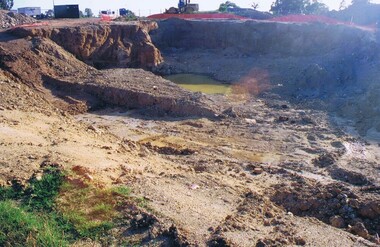
Photograph - Digital image, Frank Solomon, Development of pig farm to residential blocks, 4, 02/08/2009
... ...weidlich road greensborough...A view of the redevelopment of the pig farm in Weidlich Road Greensborough, owned by Werner Hanusch. ...Greensborough Historical Society 34A Glenauburn Road Lower Plenty Lower Plenty melbourne A view of the redevelopment of the pig farm in Weidlich Road Greensborough, owned by Werner Hanusch. ...A view of the redevelopment of the pig farm in Weidlich Road Greensborough, owned by Werner Hanusch. The land was used as a pig farm and quarry from 1954 and this photo shows early stages of the land being subdivided into the Evelyn Way estate. This project of fifty, one double storey, dwellings was commenced on 2/8/2009 and completed on 6/2/2011.An example of the changing land use in Greensborough, from farming to residential.Digital copy of colour photographwerner otto fritz hanusch, pig farm st helena, weidlich road greensborough, one evelyn way greensborough -
 Greensborough Historical Society
Photograph - Digital image, Frank Solomon, Development of pig farm to residential blocks, 5, 02/08/2009
... ...weidlich road greensborough...A view of the redevelopment of the pig farm in Weidlich Road Greensborough, owned by Werner Hanusch. ...Greensborough Historical Society 34A Glenauburn Road Lower Plenty Lower Plenty melbourne A view of the redevelopment of the pig farm in Weidlich Road Greensborough, owned by Werner Hanusch. ...A view of the redevelopment of the pig farm in Weidlich Road Greensborough, owned by Werner Hanusch. The land was used as a pig farm and quarry from 1954 and this photo shows early stages of the land being subdivided into the Evelyn Way estate. This project of fifty, one double storey, dwellings was commenced on 2/8/2009 and completed on 6/2/2011.An example of the changing land use in Greensborough, from farming to residential.Digital copy of colour photographwerner otto fritz hanusch, pig farm st helena, weidlich road greensborough, one evelyn way greensborough -
 Eltham District Historical Society Inc
Book, Diamond Creek Basin Study. Part 1, A Compendium of Factors Relevant to Stormwater Flows, 1980
... ...weidlich road...Eltham District Historical Society Inc 728 Main Rd Eltham melbourne Basin Studies are studies to evaluate water supply and demand and help ensure reliable water supplies by identifying strategies to address imbalances in water supply and demand. aerial photographs allendale road arthurs creek mine arthurs creek road bridge arthurs creek bald spur look-out bank protection bolton steet bridge street bridge bridge street bridges challenger street chute street construction coolaroo drive culvert deep creek diamond creek basin diamond creek region diamond creek diamond street bridge drainage works eltham lower park eltham town park eltham trestle bridge eltham west drains eltham erosion flood management floods footbridge glen katherine estate gold mining gum glade hurstbridge kangaroo ground kinglake escarpment kinglake national park latiners hat factory main road bridge main road masons falls melbourne metropolitan board of works, monash bridge mount sugarloaf nillumbik park orchards railway culvert railway line ramptons road real estate advertisement research creek st helena east drain st helena road st helena storm sewers stormwater sugarloaf-preston transfer main crossing susan street union mine village pond water flow watkins street wattletree road weidlich road wingrove park yarra river zig zag road water supply basin study Spiral Bound. 157 leaves in various foliations (some folded) : illustrated. ...Basin Studies are studies to evaluate water supply and demand and help ensure reliable water supplies by identifying strategies to address imbalances in water supply and demand.Spiral Bound. 157 leaves in various foliations (some folded) : illustrated. (some colour.), maps (some colour.)aerial photographs, allendale road, arthurs creek mine, arthurs creek road bridge, arthurs creek, bald spur look-out, bank protection, bolton steet, bridge street bridge, bridge street, bridges, challenger street, chute street, construction, coolaroo drive, culvert, deep creek, diamond creek basin, diamond creek region, diamond creek, diamond street bridge, drainage works, eltham lower park, eltham town park, eltham trestle bridge, eltham west drains, eltham, erosion, flood management, floods, footbridge, glen katherine estate, gold mining, gum glade, hurstbridge, kangaroo ground, kinglake escarpment, kinglake national park, latiners hat factory, main road bridge, main road, masons falls, melbourne metropolitan board of works, monash bridge, mount sugarloaf, nillumbik park, orchards, railway culvert, railway line, ramptons road, real estate advertisement, research creek, st helena east drain, st helena road, st helena, storm sewers, stormwater, sugarloaf-preston transfer main crossing, susan street, union mine, village pond, water flow, watkins street, wattletree road, weidlich road, wingrove park, yarra river, zig zag road, water supply, basin study -
 Eltham District Historical Society Inc
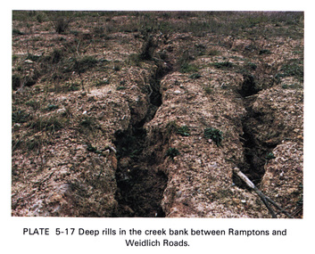
Work on paper (Sub-Item) - Photograph, Deep rills in the creek bank between Rampstons and Weidlich Roads
... Colour photograph of deep rills in the Diamond Creek bank between Rampstons and Weidlich Roads, Eltham North. The shallow channels are cut into the soil by the erosive action of flowing water....Eltham District Historical Society Inc 728 Main Rd Eltham melbourne Colour photograph of deep rills in the Diamond Creek bank between Rampstons and Weidlich Roads, Eltham North. The shallow channels are cut into the soil by the erosive action of flowing water. eltham creek bank erosion eltham north Image printed on A4 page from 04997 Diamond Creek Basin Study, 1980 Deep rills in the creek bank between Rampstons and Weidlich Roads Work on paper Photograph ...Colour photograph of deep rills in the Diamond Creek bank between Rampstons and Weidlich Roads, Eltham North. The shallow channels are cut into the soil by the erosive action of flowing water.eltham, creek bank, erosion, eltham north -
 Greensborough Historical Society
Map, Melbourne and Metropolitan Board of Works. Survey Division, MMBW, Yarra 2500 / 14.22. St Helena, St Katherine's Church, 1979_08
... Prominent streets St Helena Road, Weidlich Road, Yan Yean Road and Allumba Drive. ...Prominent streets St Helena Road, Weidlich Road, Yan Yean Road and Allumba Drive. ...Melbourne and Metropolitan Board of Works. Yarra 2500 [base map] 14.22. St Helena, St Katherine's Church. Parish of Nillumbik 3310. Municipality of Diamond Valley 257. Prominent streets St Helena Road, Weidlich Road, Yan Yean Road and Allumba Drive. Features include St Katherine's Church of England and the St Helena Secondary College site.MMBW Map in 1:2500 [scale] series. Cream parchment with green tape reinforcing on edges and punched holes on left edge.mmbw, melbourne and metropolitan board of works, shire of diamond valley, st helena - maps, st katherines church st helena -
 Greensborough Historical Society
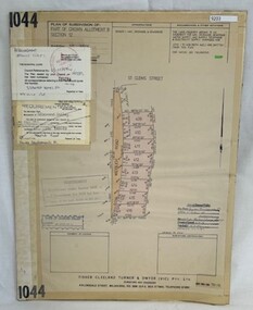
Poster - Planning Document, Shire of Diamond Valley et al, Subdivision Plan # 1044 - Parish of Nillumbik, County Bourke, Crown Allotment B Section 12, Eltham North, 1981-1987
... This subdivision plan includes Weidlich Road and St Clems Street. The developer for this subdivision is Taunton Developments and the Surveyors are Fisher Cleeland Turner & Dwyer Vic, Surveyors and Engineers....This subdivision plan includes Weidlich Road and St Clems Street. The developer for this subdivision is Taunton Developments and the Surveyors are Fisher Cleeland Turner & Dwyer Vic, Surveyors and Engineers. ...Subdivision Plan # 1044 - Parish of Nillumbik, County Bourke, Crown Allotment B Section 12, Eltham North. This subdivision plan includes Weidlich Road and St Clems Street. The developer for this subdivision is Taunton Developments and the Surveyors are Fisher Cleeland Turner & Dwyer Vic, Surveyors and Engineers.An example of hard copy subdivision plans from the Greensborough area. Mainly from the Shire of Diamond Valley era (1964-1994).Plan (single sided) mounted on heavy card. Stamped and handwritten Council permissions, dates and other details. subdivision plans, shire of diamond valley, taunton developments -
 Greensborough Historical Society
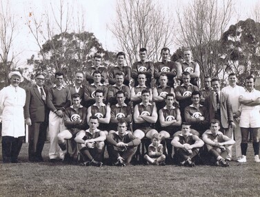
Photograph, Greensborough Football Club, Greensborough Football Club 1961, 1961_
... Road Lower Plenty Lower Plenty melbourne Greensborough Football Club, First Eighteen, Premiers 1961, Diamond Valley League. Names supplied by Gary Partington. Back row, Left to right: Rob Wickes, not known, John Crellin, Don Bell, Ian Bryant; 2nd row from back: Jim Kill, Dick Ward, Arthur Cattach, Ern Bishop, Frank Londrigan, Trevor Partington, Graham Geer, Brian Eltham, Jack Maurer, Tom Tobin, John Ely, Ron Hall; 3rd row from back: Joh Nolan, Rob Wasley, David Wickes, Joe Murphy (Captain/Coach), Len Mullenger, Don Williams; Front row: Fred Anderson, Brian Weidlich, Peter Londrigan (mascot), Trevor Browning, Ron Reynolds. greensborough football club diamond valley league . ...Greensborough Football Club, First Eighteen, Premiers 1961, Diamond Valley League. Names supplied by Gary Partington. Back row, Left to right: Rob Wickes, not known, John Crellin, Don Bell, Ian Bryant; 2nd row from back: Jim Kill, Dick Ward, Arthur Cattach, Ern Bishop, Frank Londrigan, Trevor Partington, Graham Geer, Brian Eltham, Jack Maurer, Tom Tobin, John Ely, Ron Hall; 3rd row from back: Joh Nolan, Rob Wasley, David Wickes, Joe Murphy (Captain/Coach), Len Mullenger, Don Williams; Front row: Fred Anderson, Brian Weidlich, Peter Londrigan (mascot), Trevor Browning, Ron Reynolds. Team photograph of Greensborough Football Club. Not mounted. .greensborough football club, diamond valley league -
 Greensborough Historical Society
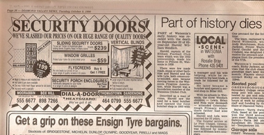
Newspaper Clipping, Diamond Valley News, Part of history dies: Harold Weidlich, 09/10/1990
... Greensborough Historical Society 34A Glenauburn Road Lower Plenty Lower Plenty melbourne This obituary for Watsonia man Harold Weidlich was written by Rosalie Bray. ...This obituary for Watsonia man Harold Weidlich was written by Rosalie Bray.Harold Weidlich was a member of the Watsonia Progress Association and a founding member of the Watsonia Cricket Club. He was also a local butcher.Copy of newspaper article "Local Scene in Watsonia"harold weidlich, watsonia progress association, watsonia cricket club, rosalie bray