Showing 29 items matching "weigh bridge"
-
 Glenelg Shire Council Cultural Collection
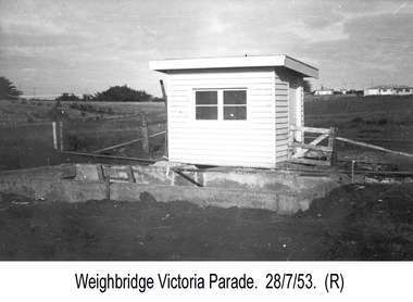
Photograph - Photograph - Portland Harbour Trust - Weigh Bridge, Victoria Parade, 1953
... Photograph - Portland Harbour Trust - Weigh Bridge, Victoria Parade...View of Weigh Bridge..../ Date taken 28-7-53/ SUBJECT./ Weigh Bridge. / Victoria Parade. (Ink stamp with blue pen and pencil additions, centre)..../ Date taken 28-7-53/ SUBJECT./ Weigh Bridge. / Victoria Parade. (Ink stamp with blue pen and pencil additions, centre) View of Weigh Bridge Photograph Photograph - Portland Harbour Trust - Weigh Bridge, Victoria Parade Portland Harbour Trust ...Port of Portland Authority archivesFront: (no inscriptions) Back: P.H.T./ Print No. 4/21 Neg. No ..../ Date taken 28-7-53/ SUBJECT./ Weigh Bridge. / Victoria Parade. (Ink stamp with blue pen and pencil additions, centre)port of portland archives -
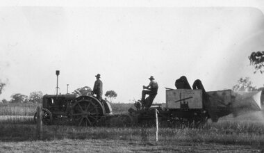
 Bendigo Historical Society Inc.
Slide - Mouat Crawford Collection: Farming Life in the Wimmera, 1960s
... ...weigh bridge...History House 11 Mackenzie Street Bendigo goldfields BHS Collection farming wimmera wheat silo weigh bridge mouat crawford collection Weighing Bulk Wheat Slide Mouat Crawford Collection: Farming Life in the Wimmera ...BHS CollectionWeighing Bulk Wheatfarming, wimmera, wheat, silo, weigh bridge, mouat crawford collection -
 Marysville & District Historical Society
THE TRIANGLE NEWS-VOL 41 NO 39-OCTOBER 10 2014
... ...new weigh bridge at alexandra landfill ready for use...marysville victoria australia the skate park new bbq canopy community foundation what's on when in october the committee of management of the gallipoli park precinct marysville community market creative triangle new weigh bridge at alexandra landfill ready for use murrindindi shire council marysville golf report church notices annual timber memorial service at heritage pioneers chapel mayor's chair by cr margaret rae retail opportunity temporary closure of alexandra library councillor comment cr john kennedy cheviot ward emotions anonymous international meeting adverisements friends of marysville walks holly eradication program narbethong news from country touch pink lunch pink ribbon day national breast cancer foundation marysville triangle real estate dalton fiske foundation friends of marysville working bee beauty spot walk triangle community dancers social dance at buxton hall australian sparkling wine show business breakfast gala awards dinner community tasting evening & bbq community light the night buxton progress assocn vale kathleen brettoner buxton bootcamp marysville ses needs volunteers tenders auction at buxton hall proceeds to national breast cancer foundation adventurous cooks hume joint kerbside tender australian sparkling wine show brings marysville to melbourne THE TRIANGLE NEWS-VOL 41 NO 39-OCTOBER 10 2014 ...marysville, victoria, australia, the skate park, new bbq canopy, community foundation, what's on when in october, the committee of management of the gallipoli park precinct, marysville community market, creative triangle, new weigh bridge at alexandra landfill ready for use, murrindindi shire council, marysville golf report, church notices, annual timber memorial service at heritage pioneers chapel, mayor's chair by cr margaret rae, retail opportunity, temporary closure of alexandra library, councillor comment cr john kennedy cheviot ward, emotions anonymous international meeting, adverisements, friends of marysville walks holly eradication program narbethong, news from country touch, pink lunch, pink ribbon day, national breast cancer foundation, marysville triangle real estate, dalton fiske foundation, friends of marysville working bee beauty spot walk, triangle community dancers, social dance at buxton hall, australian sparkling wine show business breakfast, gala awards dinner, community tasting evening & bbq, community light the night, buxton progress assocn, vale kathleen brettoner, buxton bootcamp, marysville ses needs volunteers, tenders, auction at buxton hall, proceeds to national breast cancer foundation, adventurous cooks, hume joint kerbside tender, australian sparkling wine show brings marysville to melbourne -
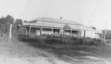
 Linton and District Historical Society Inc
Photograph, Old Linton Fire Station, circa 1930
... "Front of the old/ fire brigade at/ Linton/ Linton weigh bridge"....Linton Weighbridge Linton Fire Station "Front of the old/ fire brigade at/ Linton/ Linton weigh bridge". Small black and white photograph of wooden building, with small hut on LHS, gas lamp in centre and large expanse of road in front. ...Linton fire station pre 1939 - at LHS is the Linton weighbridge used until the 1930s. The lamp on the fire station was powered by gas.Small black and white photograph of wooden building, with small hut on LHS, gas lamp in centre and large expanse of road in front."Front of the old/ fire brigade at/ Linton/ Linton weigh bridge".linton weighbridge, linton fire station -
 Sunbury Family History and Heritage Society Inc.
Photograph, C1920S
... A non-digital black and white photograph of the former weigh bridge and surrounding areas on the east side of the Sunbury Railway Station precinct. ...Sunbury Railway Station Goods freight A non-digital black and white photograph of the former weigh bridge and surrounding areas on the east side of the Sunbury Railway Station precinct. ...Sunbury Railway Station was an important centre and stop on the Bendigo- Echuca train line. Many goods were weighed loaded, offloaded stored in the storage sheds for the surrounding districts at this centre. The Sunbury Railway Station was an important junction centre for the former Shire of Bulla and surrounding districts.A non-digital black and white photograph of the former weigh bridge and surrounding areas on the east side of the Sunbury Railway Station precinct. sunbury railway station, goods freight -
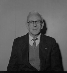
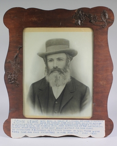 Bendigo Historical Society Inc.
Photograph - Photograph 0f John Lewis
... John Lewis built a house and garage in Boort with a Weighing Bridge 1920 - 1940. He owned six buses in Bendigo....History House 11 Mackenzie Street Bendigo goldfields John Lewis built a house and garage in Boort with a Weighing Bridge 1920 - 1940. He owned six buses in Bendigo. ...John Lewis built a house and garage in Boort with a Weighing Bridge 1920 - 1940. He owned six buses in Bendigo.A retouched black and white photograph of John Lewis head and shoulders, wearing a hat, tie, waistcoat and coat. Behind glass in a brown plywood frame with wooden carvings of birds and flowers attached. A brief history of John Lewis is written in blue ink on white tape attached to the frame.john lewis -
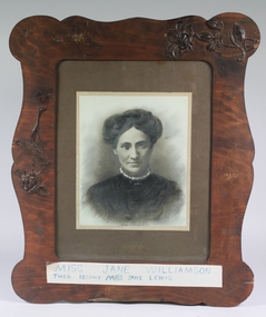 Bendigo Historical Society Inc.
Photograph - Photograph of Jane Williamson
... John Lewis built a house and garage in Boort with a Weighing Bridge 1920 - 1940. He owned six buses in Bendigo....History House 11 Mackenzie Street Bendigo goldfields John Lewis built a house and garage in Boort with a Weighing Bridge 1920 - 1940. He owned six buses in Bendigo. ...John Lewis built a house and garage in Boort with a Weighing Bridge 1920 - 1940. He owned six buses in Bendigo.A retouched black and white photograph of head and shoulders of Jane Williamson wearing a black garment with a white frilled collar. Behind glass in a brown plywood frame with wooden carvings of birds and flowers attached. Written in blue ink on white tape attached to the frame is MISS JANE WILLIAMSON THEN BECOME MR'S JANE LEWISjohn lewis, jane lewis, jane williamson -
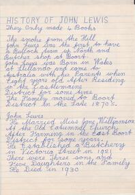 Bendigo Historical Society Inc.
Document - History of John Lewis, Lewis Collection
... Lewis Lewis built a house and garage in Boort with a Weighing Bridge 1920 - 1940. He owned six buses in Bendigo....History House 11 Mackenzie Street Bendigo goldfields Lewis Lewis built a house and garage in Boort with a Weighing Bridge 1920 - 1940. He owned six buses in Bendigo. ...Lewis Lewis built a house and garage in Boort with a Weighing Bridge 1920 - 1940. He owned six buses in Bendigo.Two documents detailing the history of Lewis Lewis and John Lewis. One is handwritten (Image 1a) (John Lewis) in blue pen and the other is a two-page originally handwritten photocopy (image 1b,c) about Lewis Lewis - 'how he got started'. lewis lewis, john lewis, buses, reg ansett -
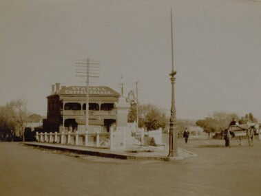 Stawell Historical Society Inc
Photograph, Soldiers’ Memorial World War 1 in Main Street in front of the Coffee Palace
... The Soldier's Memorial is surround by a timber fence with an ornate pole possible a flagpole in front of 2 timber seats. The weigh bridge can be seen behind the memorial and Infront of the Stawell Coffee Palace. ...The Soldier's Memorial is surround by a timber fence with an ornate pole possible a flagpole in front of 2 timber seats. The weigh bridge can be seen behind the memorial and Infront of the Stawell Coffee Palace. ...Soldiers’ Memorial Street scene with Coffee Palace formerly Castlemaine Hotel. Two people in a horse drawn wagon are driving away from the corner on the right hand side while a man dressed in a suit is walking toward the corner. A telegraph pole is behind the memorial and a decorate pole sits on the corner.Small sepia Street scene showing Soldiers Memorial, Coffee Palace building in the background. The Soldier's Memorial is surround by a timber fence with an ornate pole possible a flagpole in front of 2 timber seats. The weigh bridge can be seen behind the memorial and Infront of the Stawell Coffee Palace. Two people in a horse drawn and cart are driving away from the corner on the right hand side while a man dressed in a suit is walking toward the corner.Coffee Palace Stawellstawell ww1 -
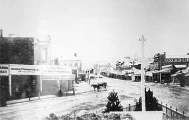 Stawell Historical Society Inc
Photograph, Main Street looking East from Coffee Palace area 1880
... Main Street Looking East 1880 from weigh bridge area, taken from Coffee Palace verandah. ...Stawell Historical Society Inc 46 Longfield St Stawell grampians Main Street Looking East 1880 from weigh bridge area, taken from Coffee Palace verandah. ...Main Street Looking East 1880 from weigh bridge area, taken from Coffee Palace verandah. Two story buildings with veranda's. Horse drawn vehicle center of image. Post office and Town Hall visible in background. Bond Drapery. J & A Price Wine Spirits. Bond Draper sign on right. Two Poppet Heads on Big Hill are the No2 North Waterloo and the Waterloo and Argyle Mines.Black and white photograph looking East along Main Street from Weighbridge area where two streets join. Horse drawn buggy in center of street with buggy. Big Hill in distance with two poppet heads just visible.stawell businesses streetscape -
 Kilmore Historical Society
Photograph, Colonial Bank of Australasia, 1883
... Kilmore Historical Society "In front of this Hotel was a weigh-bridge there was big drain covered with a grating, with the tunnel going across the road diagonally, Kids used to walk under it. ...Kilmore Historical Society "In front of this Hotel was a weigh-bridge there was big drain covered with a grating, with the tunnel going across the road diagonally, Kids used to walk under it. ...Donated by Dan Clancy. 1 Powlett Street, Kilmore, Mitchell Shire , Victoria, Australia10cm x 20cm black and white photograph of 1 Powlett street, former colonial bank of Australasia. Corner of Powlett Street and Lancefield Road, Kilmore. Reproduction on standard photographic paper, possibly because of damage seen in the reproduction. The image has a low contrast possibly from incorrect development or other damage. Two story light coloured rendered building with blue stone street curbing. Seven figures stand outside of the building, six men and one child. The photograph was take around 1883 and reproduced in 1986.Printed on the back: 104/2.6 200486/2 Colonial Bank of Australia - cnr Powlett & Lancefield Rd. Kilmore Historical Society "In front of this Hotel was a weigh-bridge there was big drain covered with a grating, with the tunnel going across the road diagonally, Kids used to walk under it. The window panes on the corner were curved, as was the door." 2.10/86 Colonial bank of Australia Cnr Lancefield Rd. & Powlett St. C. 1883 (bank oved to opposite Mill St. on that date.) Dan Clancy Collection.hotels, 19th century -
 Sunshine and District Historical Society Incorporated
Document - Massey Ferguson Sunshine Factory Building Details & Descriptions
... 4697.01 - Massey Ferguson Sunshine Factory Building Details & Descriptions - Ballarat Shop 4697.02 - Massey Ferguson Sunshine Factory Building Details & Descriptions - Blinder & Mower Shop and Gates & Harrows 4697.03 - Massey Ferguson Sunshine Factory Building Details & Descriptions - Engine Works 4697.04 - Massey Ferguson Sunshine Factory Building Details & Descriptions - Factory Management (Cost Office, Planning Office & Pay Office 4697.05 - Massey Ferguson Sunshine Factory Building Details & Descriptions - Fitters & Assembly (Sub Assembly) 4697.06 - Massey Ferguson Sunshine Factory Building Details & Descriptions - Gate House 1 & 2 4697.07 - Massey Ferguson Sunshine Factory Building Details & Descriptions - Pattern Shops (Wood & Metal) 4697.08 - Massey Ferguson Sunshine Factory Building Details & Descriptions - Machine Shop 4697.09 - Massey Ferguson Sunshine Factory Building Details & Descriptions - Medical Centre (First Aid Room) 4697.10 - Massey Ferguson Sunshine Factory Building Details & Descriptions - Quality Control (Inspection) 4697.11 - Massey Ferguson Sunshine Factory Building Details & Descriptions - Sheet Iron 4697.12 - Massey Ferguson Sunshine Factory Building Details & Descriptions - Tool Rooms No 7 & No 11, Bolt Shop & Machine Shop 4697.13 - Massey Ferguson Sunshine Factory Building Details & Descriptions - Welding & Oxy Cutting 4697.14 - Massey Ferguson Sunshine Factory Building Details & Descriptions - Weigh Bridge...Massey Ferguson Sunshine Harvester Works 4697.01 - Massey Ferguson Sunshine Factory Building Details & Descriptions - Ballarat Shop 4697.02 - Massey Ferguson Sunshine Factory Building Details & Descriptions - Blinder & Mower Shop and Gates & Harrows 4697.03 - Massey Ferguson Sunshine Factory Building Details & Descriptions - Engine Works 4697.04 - Massey Ferguson Sunshine Factory Building Details & Descriptions - Factory Management (Cost Office, Planning Office & Pay Office 4697.05 - Massey Ferguson Sunshine Factory Building Details & Descriptions - Fitters & Assembly (Sub Assembly) 4697.06 - Massey Ferguson Sunshine Factory Building Details & Descriptions - Gate House 1 & 2 4697.07 - Massey Ferguson Sunshine Factory Building Details & Descriptions - Pattern Shops (Wood & Metal) 4697.08 - Massey Ferguson Sunshine Factory Building Details & Descriptions - Machine Shop 4697.09 - Massey Ferguson Sunshine Factory Building Details & Descriptions - Medical Centre (First Aid Room) 4697.10 - Massey Ferguson Sunshine Factory Building Details & Descriptions - Quality Control (Inspection) 4697.11 - Massey Ferguson Sunshine Factory Building Details & Descriptions - Sheet Iron 4697.12 - Massey Ferguson Sunshine Factory Building Details & Descriptions - Tool Rooms No 7 & No 11, Bolt Shop & Machine Shop 4697.13 - Massey Ferguson Sunshine Factory Building Details & Descriptions - Welding & Oxy Cutting 4697.14 - Massey Ferguson Sunshine Factory Building Details & Descriptions - Weigh Bridge A collection of printouts detailing various workshops and building at the Sunshine Factory. ...4697.01 - Massey Ferguson Sunshine Factory Building Details & Descriptions - Ballarat Shop 4697.02 - Massey Ferguson Sunshine Factory Building Details & Descriptions - Blinder & Mower Shop and Gates & Harrows 4697.03 - Massey Ferguson Sunshine Factory Building Details & Descriptions - Engine Works 4697.04 - Massey Ferguson Sunshine Factory Building Details & Descriptions - Factory Management (Cost Office, Planning Office & Pay Office 4697.05 - Massey Ferguson Sunshine Factory Building Details & Descriptions - Fitters & Assembly (Sub Assembly) 4697.06 - Massey Ferguson Sunshine Factory Building Details & Descriptions - Gate House 1 & 2 4697.07 - Massey Ferguson Sunshine Factory Building Details & Descriptions - Pattern Shops (Wood & Metal) 4697.08 - Massey Ferguson Sunshine Factory Building Details & Descriptions - Machine Shop 4697.09 - Massey Ferguson Sunshine Factory Building Details & Descriptions - Medical Centre (First Aid Room) 4697.10 - Massey Ferguson Sunshine Factory Building Details & Descriptions - Quality Control (Inspection) 4697.11 - Massey Ferguson Sunshine Factory Building Details & Descriptions - Sheet Iron 4697.12 - Massey Ferguson Sunshine Factory Building Details & Descriptions - Tool Rooms No 7 & No 11, Bolt Shop & Machine Shop 4697.13 - Massey Ferguson Sunshine Factory Building Details & Descriptions - Welding & Oxy Cutting 4697.14 - Massey Ferguson Sunshine Factory Building Details & Descriptions - Weigh Bridgemassey ferguson, sunshine harvester works -
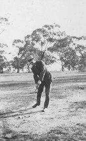
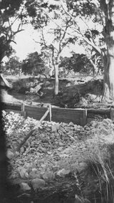
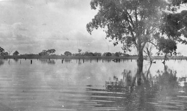
 Stawell Historical Society Inc
Photograph, Photo Collection Claude Smith & Eileen Coppin
... Page 6 Book Warranook to Wal Wal -4 Home manufactured Tractor Wheel -5 Three ladies 1920’s -6 Picnic -7 Two Girls -8 Sheering Shed -9 Farmhouse with garden -10 Group of men possibly football team -11 Farmhouse -12 War Memorial Stawell with Weigh Bridge and Coffee Palace -13 Car crossing creek -14 Gathering at Wal Wal school -15 Accommodation on wheels -16 4 people standing around a car Perhaps changing a wheel -17 Team of 7 horses drawing a buggy of bagged wheat- -18 Flooded Mt William Creek with shed involvement -19 Group of men dressed in football clothes 2 umpires dressed in white on the R -20 4 people playing tennis -21 Man dressed in a suit and hat teeing off a golf shot -22 a man, a woman and a child near a steam driven timber mill -23 suited men watching a tractor ploughing -24 a weatherboard building on elevated stumps, possibly just been placed there -25 2 coated men pushing a bogged open tourer car -26 a tractor pulling a plough with suited men on both -27 large pile of bagged grain at a railway siding -28 2 women dressed in long clothing -29 a woman and a boy on a veranda -30 a smiling formally dressed woman holding a box -31 probable small weir in a dry river bed -32 Man in army uniform with 1920s tourer car with roof up -33 Man on platform of railway siding He is holding a hoop -34 studio photo of young girl -35 Large pile of bagged wheat at a railway siding -36 Half of a house on a bridge -37 Hatted woman on a horse -38 large group of formally dressed people outside Wal Wal school -39 1930s utility with 2 boys on bumper bar Headlights blacked out in early 1940s -40 2 men with a 4 wheeled horse drawn vehicle. ...Page 6 Book Warranook to Wal Wal -4 Home manufactured Tractor Wheel -5 Three ladies 1920’s -6 Picnic -7 Two Girls -8 Sheering Shed -9 Farmhouse with garden -10 Group of men possibly football team -11 Farmhouse -12 War Memorial Stawell with Weigh Bridge and Coffee Palace -13 Car crossing creek -14 Gathering at Wal Wal school -15 Accommodation on wheels -16 4 people standing around a car Perhaps changing a wheel -17 Team of 7 horses drawing a buggy of bagged wheat- -18 Flooded Mt William Creek with shed involvement -19 Group of men dressed in football clothes 2 umpires dressed in white on the R -20 4 people playing tennis -21 Man dressed in a suit and hat teeing off a golf shot -22 a man, a woman and a child near a steam driven timber mill -23 suited men watching a tractor ploughing -24 a weatherboard building on elevated stumps, possibly just been placed there -25 2 coated men pushing a bogged open tourer car -26 a tractor pulling a plough with suited men on both -27 large pile of bagged grain at a railway siding -28 2 women dressed in long clothing -29 a woman and a boy on a veranda -30 a smiling formally dressed woman holding a box -31 probable small weir in a dry river bed -32 Man in army uniform with 1920s tourer car with roof up -33 Man on platform of railway siding He is holding a hoop -34 studio photo of young girl -35 Large pile of bagged wheat at a railway siding -36 Half of a house on a bridge -37 Hatted woman on a horse -38 large group of formally dressed people outside Wal Wal school -39 1930s utility with 2 boys on bumper bar Headlights blacked out in early 1940s -40 2 men with a 4 wheeled horse drawn vehicle. ...Black and White Photographic Collection of Various Sizes 7235 Piles of Wheat Baggs -1 Family Group in garden -2 David George & Thomas -3 Arch Maher (front) and George Baylie Carting Wool from PinGrove, around 1915. Page 6 Book Warranook to Wal Wal -4 Home manufactured Tractor Wheel -5 Three ladies 1920’s -6 Picnic -7 Two Girls -8 Sheering Shed -9 Farmhouse with garden -10 Group of men possibly football team -11 Farmhouse -12 War Memorial Stawell with Weigh Bridge and Coffee Palace -13 Car crossing creek -14 Gathering at Wal Wal school -15 Accommodation on wheels -16 4 people standing around a car Perhaps changing a wheel -17 Team of 7 horses drawing a buggy of bagged wheat- -18 Flooded Mt William Creek with shed involvement -19 Group of men dressed in football clothes 2 umpires dressed in white on the R -20 4 people playing tennis -21 Man dressed in a suit and hat teeing off a golf shot -22 a man, a woman and a child near a steam driven timber mill -23 suited men watching a tractor ploughing -24 a weatherboard building on elevated stumps, possibly just been placed there -25 2 coated men pushing a bogged open tourer car -26 a tractor pulling a plough with suited men on both -27 large pile of bagged grain at a railway siding -28 2 women dressed in long clothing -29 a woman and a boy on a veranda -30 a smiling formally dressed woman holding a box -31 probable small weir in a dry river bed -32 Man in army uniform with 1920s tourer car with roof up -33 Man on platform of railway siding He is holding a hoop -34 studio photo of young girl -35 Large pile of bagged wheat at a railway siding -36 Half of a house on a bridge -37 Hatted woman on a horse -38 large group of formally dressed people outside Wal Wal school -39 1930s utility with 2 boys on bumper bar Headlights blacked out in early 1940s -40 2 men with a 4 wheeled horse drawn vehicle. Thatched farm sheds in the background -41 flood scene, Glenorchy -42 Wimmera river in flood Glenorchy -43 Pleasant Creek Hospital with old car on left c.1920 -44 2 women, a man and a boy playing tennis Callawadda 1925 -45 “A lesson in cow cockying”. A boy watching 2 women milking a cow. 1925 -46 A group of men, women and 2 children at a working bee. -47 Wedding group with best man and maid of honour and 2 children carrying flowers. Front of car with streamers -48 wedding couple with best man and matron of honour and 2 flower girls. 2 cars to the left. 1925 -49 Group of school children in national costumes -50 Tractor, harvester , 2 man and some upright bags of crop. -51 2 men harvesting with a tractor pulling a harvester -52 5 bags of cereal with a man, tractor and harvesting in the background. -53 3 wheeled horse drawn vehicle with a woman on the cart -54 Derailed train carriage , still upright. Adelaide Express 1923 -55 wheels of over turned railway carriage Several people in background 1923 -56 close up of train carriage wheel and bogey. Several people in background. 1923 -57 5 draught horses abreast, pulling a farm implement with a man by the implement. -58 2 hay stacks shaped with high pitch A man and a fence in the foreground -59 Huge log of wood on a 4 wooden wheeled carrier -60 4 people standing on the spillover on the Little Wimmera -61 car with a woman driver, holding a young child. A boy standing nearby -62 3 men and 2 women sitting at Glenorchy tennis -63 4 horses with a farm implement -64 3 men, a horse and boxes on the left -65 5 people at a tennis party -66 4 tennis players at Glenorchy 1925 -67 group of men dressed in white, women in white with white bonnets standing around a seated man and woman -68 veranda in front of a country home with lattice on a side of the house -69 front of a house with a family of 5 on the veranda -70 a couple standing in front of Wal Wal school, nearing completion Various - -
 Stawell Historical Society Inc
Photograph, Photo Collection Claude Smith & Eileen Coppin
... Page 6 Book Warranook to Wal Wal -4 Home manufactured Tractor Wheel -5 Three ladies 1920’s -6 Picnic -7 Two Girls -8 Sheering Shed -9 Farmhouse with garden -10 Group of men possibly football team -11 Farmhouse -12 War Memorial Stawell with Weigh Bridge and Coffee Palace -13 Car crossing creek -14 Gathering at Wal Wal school -15 Accommodation on wheels -16 4 people standing around a car Perhaps changing a wheel -17 Team of 7 horses drawing a buggy of bagged wheat- -18 Rowe's sawmill during flood of Dunmunkle Creek c.1920 -19 Group of men dressed in football clothes 2 umpires dressed in white on the R -20 4 people playing tennis -21 Man dressed in a suit and hat teeing off a golf shot -22 a man, a woman and a child near a steam driven timber mill -23 suited men watching a tractor ploughing -24 a weatherboard building on elevated stumps, possibly just been placed there -25 2 coated men pushing a bogged open tourer car -26 a tractor pulling a plough with suited men on both -27 large pile of bagged grain at a railway siding -28 2 women dressed in long clothing -29 a woman and a boy on a veranda -30 a smiling formally dressed woman holding a box -31 probable small weir in a dry river bed -32 Man in army uniform with 1920s tourer car with roof up -33 Man on platform of railway siding He is holding a hoop -34 studio photo of young girl -35 Large pile of bagged wheat at a railway siding -36 Half of a house on a bridge -37 Hatted woman on a horse -38 large group of formally dressed people outside Wal Wal school -39 1930s utility with 2 boys on bumper bar Headlights blacked out in early 1940s -40 2 men with a 4 wheeled horse drawn vehicle. ...Page 6 Book Warranook to Wal Wal -4 Home manufactured Tractor Wheel -5 Three ladies 1920’s -6 Picnic -7 Two Girls -8 Sheering Shed -9 Farmhouse with garden -10 Group of men possibly football team -11 Farmhouse -12 War Memorial Stawell with Weigh Bridge and Coffee Palace -13 Car crossing creek -14 Gathering at Wal Wal school -15 Accommodation on wheels -16 4 people standing around a car Perhaps changing a wheel -17 Team of 7 horses drawing a buggy of bagged wheat- -18 Rowe's sawmill during flood of Dunmunkle Creek c.1920 -19 Group of men dressed in football clothes 2 umpires dressed in white on the R -20 4 people playing tennis -21 Man dressed in a suit and hat teeing off a golf shot -22 a man, a woman and a child near a steam driven timber mill -23 suited men watching a tractor ploughing -24 a weatherboard building on elevated stumps, possibly just been placed there -25 2 coated men pushing a bogged open tourer car -26 a tractor pulling a plough with suited men on both -27 large pile of bagged grain at a railway siding -28 2 women dressed in long clothing -29 a woman and a boy on a veranda -30 a smiling formally dressed woman holding a box -31 probable small weir in a dry river bed -32 Man in army uniform with 1920s tourer car with roof up -33 Man on platform of railway siding He is holding a hoop -34 studio photo of young girl -35 Large pile of bagged wheat at a railway siding -36 Half of a house on a bridge -37 Hatted woman on a horse -38 large group of formally dressed people outside Wal Wal school -39 1930s utility with 2 boys on bumper bar Headlights blacked out in early 1940s -40 2 men with a 4 wheeled horse drawn vehicle. ...Black and White Photographic Collection of Various Sizes 7235 Piles of Wheat Baggs -1 Family Group in garden -2 David George & Thomas -3 Arch Maher (front) and George Baylie Carting Wool from PinGrove, around 1915. Page 6 Book Warranook to Wal Wal -4 Home manufactured Tractor Wheel -5 Three ladies 1920’s -6 Picnic -7 Two Girls -8 Sheering Shed -9 Farmhouse with garden -10 Group of men possibly football team -11 Farmhouse -12 War Memorial Stawell with Weigh Bridge and Coffee Palace -13 Car crossing creek -14 Gathering at Wal Wal school -15 Accommodation on wheels -16 4 people standing around a car Perhaps changing a wheel -17 Team of 7 horses drawing a buggy of bagged wheat- -18 Rowe's sawmill during flood of Dunmunkle Creek c.1920 -19 Group of men dressed in football clothes 2 umpires dressed in white on the R -20 4 people playing tennis -21 Man dressed in a suit and hat teeing off a golf shot -22 a man, a woman and a child near a steam driven timber mill -23 suited men watching a tractor ploughing -24 a weatherboard building on elevated stumps, possibly just been placed there -25 2 coated men pushing a bogged open tourer car -26 a tractor pulling a plough with suited men on both -27 large pile of bagged grain at a railway siding -28 2 women dressed in long clothing -29 a woman and a boy on a veranda -30 a smiling formally dressed woman holding a box -31 probable small weir in a dry river bed -32 Man in army uniform with 1920s tourer car with roof up -33 Man on platform of railway siding He is holding a hoop -34 studio photo of young girl -35 Large pile of bagged wheat at a railway siding -36 Half of a house on a bridge -37 Hatted woman on a horse -38 large group of formally dressed people outside Wal Wal school -39 1930s utility with 2 boys on bumper bar Headlights blacked out in early 1940s -40 2 men with a 4 wheeled horse drawn vehicle. Thatched farm sheds in the background -41 flood scene, Glenorchy -42 Wimmera river in flood Glenorchy -43 Pleasant Creek Hospital with old car on left c.1920 -44 2 women, a man and a boy playing tennis Callawadda 1925 -45 “A lesson in cow cockying”. A boy watching 2 women milking a cow. 1925 -46 A group of men, women and 2 children at a working bee. -47 Wedding group with best man and maid of honour and 2 children carrying flowers. Front of car with streamers -48 wedding couple with best man and matron of honour and 2 flower girls. 2 cars to the left. 1925 -49 Group of school children in national costumes -50 Tractor, harvester , 2 man and some upright bags of crop. -51 2 men harvesting with a tractor pulling a harvester -52 5 bags of cereal with a man, tractor and harvesting in the background. -53 3 wheeled horse drawn vehicle with a woman on the cart -54 Derailed train carriage , still upright. Adelaide Express 1923 -55 wheels of over turned railway carriage Several people in background 1923 -56 close up of train carriage wheel and bogey. Several people in background. 1923 -57 5 draught horses abreast, pulling a farm implement with a man by the implement. -58 2 hay stacks shaped with high pitch A man and a fence in the foreground -59 Huge log of wood on a 4 wooden wheeled carrier -60 4 people standing on the spillover on the Little Wimmera -61 car with a woman driver, holding a young child. A boy standing nearby -62 3 men and 2 women sitting at Glenorchy tennis -63 4 horses with a farm implement -64 3 men, a horse and boxes on the left -65 5 people at a tennis party -66 4 tennis players at Glenorchy 1925 -67 group of men dressed in white, women in white with white bonnets standing around a seated man and woman -68 veranda in front of a country home with lattice on a side of the house -69 front of a house with a family of 5 on the veranda -70 a couple standing in front of Wal Wal school, nearing completion Various - -
 Stawell Historical Society Inc
Photograph, Photo Collection Claude Smith & Eileen Coppin
... Page 6 Book Warranook to Wal Wal -4 Home manufactured Tractor Wheel -5 Three ladies 1920’s -6 Picnic -7 Two Girls -8 Sheering Shed -9 Farmhouse with garden -10 Group of men possibly football team -11 Farmhouse -12 War Memorial Stawell with Weigh Bridge and Coffee Palace -13 Car crossing creek -14 Gathering at Wal Wal school -15 Accommodation on wheels -16 4 people standing around a car Perhaps changing a wheel -17 Team of 7 horses drawing a buggy of bagged wheat- -18 Flooded Mt William Creek with shed involvement -19 Group of men dressed in football clothes 2 umpires dressed in white on the R -20 4 people playing tennis -21 Man dressed in a suit and hat teeing off a golf shot -22 a man, a woman and a child near a steam driven timber mill -23 suited men watching a tractor ploughing -24 a weatherboard building on elevated stumps, possibly just been placed there -25 2 coated men pushing a bogged open tourer car -26 a tractor pulling a plough with suited men on both -27 large pile of bagged grain at a railway siding -28 2 women dressed in long clothing -29 a woman and a boy on a veranda -30 a smiling formally dressed woman holding a box -31 probable small weir in a dry river bed -32 Man in army uniform with 1920s tourer car with roof up -33 Man on platform of railway siding He is holding a hoop -34 studio photo of young girl -35 Large pile of bagged wheat at a railway siding -36 Half of a house on a bridge -37 Hatted woman on a horse -38 large group of formally dressed people outside Wal Wal school -39 1930s utility with 2 boys on bumper bar Headlights blacked out in early 1940s -40 2 men with a 4 wheeled horse drawn vehicle. ...Page 6 Book Warranook to Wal Wal -4 Home manufactured Tractor Wheel -5 Three ladies 1920’s -6 Picnic -7 Two Girls -8 Sheering Shed -9 Farmhouse with garden -10 Group of men possibly football team -11 Farmhouse -12 War Memorial Stawell with Weigh Bridge and Coffee Palace -13 Car crossing creek -14 Gathering at Wal Wal school -15 Accommodation on wheels -16 4 people standing around a car Perhaps changing a wheel -17 Team of 7 horses drawing a buggy of bagged wheat- -18 Flooded Mt William Creek with shed involvement -19 Group of men dressed in football clothes 2 umpires dressed in white on the R -20 4 people playing tennis -21 Man dressed in a suit and hat teeing off a golf shot -22 a man, a woman and a child near a steam driven timber mill -23 suited men watching a tractor ploughing -24 a weatherboard building on elevated stumps, possibly just been placed there -25 2 coated men pushing a bogged open tourer car -26 a tractor pulling a plough with suited men on both -27 large pile of bagged grain at a railway siding -28 2 women dressed in long clothing -29 a woman and a boy on a veranda -30 a smiling formally dressed woman holding a box -31 probable small weir in a dry river bed -32 Man in army uniform with 1920s tourer car with roof up -33 Man on platform of railway siding He is holding a hoop -34 studio photo of young girl -35 Large pile of bagged wheat at a railway siding -36 Half of a house on a bridge -37 Hatted woman on a horse -38 large group of formally dressed people outside Wal Wal school -39 1930s utility with 2 boys on bumper bar Headlights blacked out in early 1940s -40 2 men with a 4 wheeled horse drawn vehicle. ...Black and White Photographic Collection of Various Sizes 7235 Piles of Wheat Baggs -1 Family Group in garden -2 David George & Thomas -3 Arch Maher (front) and George Baylie Carting Wool from PinGrove, around 1915. Page 6 Book Warranook to Wal Wal -4 Home manufactured Tractor Wheel -5 Three ladies 1920’s -6 Picnic -7 Two Girls -8 Sheering Shed -9 Farmhouse with garden -10 Group of men possibly football team -11 Farmhouse -12 War Memorial Stawell with Weigh Bridge and Coffee Palace -13 Car crossing creek -14 Gathering at Wal Wal school -15 Accommodation on wheels -16 4 people standing around a car Perhaps changing a wheel -17 Team of 7 horses drawing a buggy of bagged wheat- -18 Flooded Mt William Creek with shed involvement -19 Group of men dressed in football clothes 2 umpires dressed in white on the R -20 4 people playing tennis -21 Man dressed in a suit and hat teeing off a golf shot -22 a man, a woman and a child near a steam driven timber mill -23 suited men watching a tractor ploughing -24 a weatherboard building on elevated stumps, possibly just been placed there -25 2 coated men pushing a bogged open tourer car -26 a tractor pulling a plough with suited men on both -27 large pile of bagged grain at a railway siding -28 2 women dressed in long clothing -29 a woman and a boy on a veranda -30 a smiling formally dressed woman holding a box -31 probable small weir in a dry river bed -32 Man in army uniform with 1920s tourer car with roof up -33 Man on platform of railway siding He is holding a hoop -34 studio photo of young girl -35 Large pile of bagged wheat at a railway siding -36 Half of a house on a bridge -37 Hatted woman on a horse -38 large group of formally dressed people outside Wal Wal school -39 1930s utility with 2 boys on bumper bar Headlights blacked out in early 1940s -40 2 men with a 4 wheeled horse drawn vehicle. Thatched farm sheds in the background -41 flood scene, Glenorchy -42 Wimmera river in flood Glenorchy -43 Pleasant Creek Hospital with old car on left c.1920 -44 2 women, a man and a boy playing tennis Callawadda 1925 -45 “A lesson in cow cockying”. A boy watching 2 women milking a cow. 1925 -46 A group of men, women and 2 children at a working bee. -47 Wedding group with best man and maid of honour and 2 children carrying flowers. Front of car with streamers -48 wedding couple with best man and matron of honour and 2 flower girls. 2 cars to the left. 1925 -49 Group of school children in national costumes -50 Tractor, harvester , 2 man and some upright bags of crop. -51 2 men harvesting with a tractor pulling a harvester -52 5 bags of cereal with a man, tractor and harvesting in the background. -53 3 wheeled horse drawn vehicle with a woman on the cart -54 Derailed train carriage , still upright. Adelaide Express 1923 -55 wheels of over turned railway carriage Several people in background 1923 -56 close up of train carriage wheel and bogey. Several people in background. 1923 -57 5 draught horses abreast, pulling a farm implement with a man by the implement. -58 2 hay stacks shaped with high pitch A man and a fence in the foreground -59 Huge log of wood on a 4 wooden wheeled carrier -60 4 people standing on the spillover on the Little Wimmera -61 car with a woman driver, holding a young child. A boy standing nearby -62 3 men and 2 women sitting at Glenorchy tennis -63 4 horses with a farm implement -64 3 men, a horse and boxes on the left -65 5 people at a tennis party -66 4 tennis players at Glenorchy 1925 -67 group of men dressed in white, women in white with white bonnets standing around a seated man and woman -68 veranda in front of a country home with lattice on a side of the house -69 front of a house with a family of 5 on the veranda -70 a couple standing in front of Wal Wal school, nearing completion Various - -
 Stawell Historical Society Inc
Photograph, Photo Collection Claude Smith & Eileen Coppin
... Page 6 Book Warranook to Wal Wal -4 Home manufactured Tractor Wheel -5 Three ladies 1920’s -6 Picnic -7 Two Girls -8 Sheering Shed -9 Farmhouse with garden -10 Group of men possibly football team -11 Farmhouse -12 War Memorial Stawell with Weigh Bridge and Coffee Palace -13 Car crossing creek -14 Gathering at Wal Wal school -15 Accommodation on wheels -16 4 people standing around a car Perhaps changing a wheel -17 Team of 7 horses drawing a buggy of bagged wheat- -18 Flooded Mt William Creek with shed involvement -19 Group of men dressed in football clothes 2 umpires dressed in white on the R -20 4 people playing tennis -21 Man dressed in a suit and hat teeing off a golf shot -22 a man, a woman and a child near a steam driven timber mill -23 suited men watching a tractor ploughing -24 a weatherboard building on elevated stumps, possibly just been placed there -25 2 coated men pushing a bogged open tourer car -26 a tractor pulling a plough with suited men on both -27 large pile of bagged grain at a railway siding -28 2 women dressed in long clothing -29 a woman and a boy on a veranda -30 a smiling formally dressed woman holding a box -31 probable small weir in a dry river bed -32 Man in army uniform with 1920s tourer car with roof up -33 Man on platform of railway siding He is holding a hoop -34 studio photo of young girl -35 Large pile of bagged wheat at a railway siding -36 Half of a house on a bridge -37 Hatted woman on a horse -38 large group of formally dressed people outside Wal Wal school -39 1930s utility with 2 boys on bumper bar Headlights blacked out in early 1940s -40 2 men with a 4 wheeled horse drawn vehicle. ...Page 6 Book Warranook to Wal Wal -4 Home manufactured Tractor Wheel -5 Three ladies 1920’s -6 Picnic -7 Two Girls -8 Sheering Shed -9 Farmhouse with garden -10 Group of men possibly football team -11 Farmhouse -12 War Memorial Stawell with Weigh Bridge and Coffee Palace -13 Car crossing creek -14 Gathering at Wal Wal school -15 Accommodation on wheels -16 4 people standing around a car Perhaps changing a wheel -17 Team of 7 horses drawing a buggy of bagged wheat- -18 Flooded Mt William Creek with shed involvement -19 Group of men dressed in football clothes 2 umpires dressed in white on the R -20 4 people playing tennis -21 Man dressed in a suit and hat teeing off a golf shot -22 a man, a woman and a child near a steam driven timber mill -23 suited men watching a tractor ploughing -24 a weatherboard building on elevated stumps, possibly just been placed there -25 2 coated men pushing a bogged open tourer car -26 a tractor pulling a plough with suited men on both -27 large pile of bagged grain at a railway siding -28 2 women dressed in long clothing -29 a woman and a boy on a veranda -30 a smiling formally dressed woman holding a box -31 probable small weir in a dry river bed -32 Man in army uniform with 1920s tourer car with roof up -33 Man on platform of railway siding He is holding a hoop -34 studio photo of young girl -35 Large pile of bagged wheat at a railway siding -36 Half of a house on a bridge -37 Hatted woman on a horse -38 large group of formally dressed people outside Wal Wal school -39 1930s utility with 2 boys on bumper bar Headlights blacked out in early 1940s -40 2 men with a 4 wheeled horse drawn vehicle. ...Black and White Photographic Collection of Various Sizes 7235 Piles of Wheat Baggs -1 Family Group in garden -2 David George & Thomas -3 Arch Maher (front) and George Baylie Carting Wool from PinGrove, around 1915. Page 6 Book Warranook to Wal Wal -4 Home manufactured Tractor Wheel -5 Three ladies 1920’s -6 Picnic -7 Two Girls -8 Sheering Shed -9 Farmhouse with garden -10 Group of men possibly football team -11 Farmhouse -12 War Memorial Stawell with Weigh Bridge and Coffee Palace -13 Car crossing creek -14 Gathering at Wal Wal school -15 Accommodation on wheels -16 4 people standing around a car Perhaps changing a wheel -17 Team of 7 horses drawing a buggy of bagged wheat- -18 Flooded Mt William Creek with shed involvement -19 Group of men dressed in football clothes 2 umpires dressed in white on the R -20 4 people playing tennis -21 Man dressed in a suit and hat teeing off a golf shot -22 a man, a woman and a child near a steam driven timber mill -23 suited men watching a tractor ploughing -24 a weatherboard building on elevated stumps, possibly just been placed there -25 2 coated men pushing a bogged open tourer car -26 a tractor pulling a plough with suited men on both -27 large pile of bagged grain at a railway siding -28 2 women dressed in long clothing -29 a woman and a boy on a veranda -30 a smiling formally dressed woman holding a box -31 probable small weir in a dry river bed -32 Man in army uniform with 1920s tourer car with roof up -33 Man on platform of railway siding He is holding a hoop -34 studio photo of young girl -35 Large pile of bagged wheat at a railway siding -36 Half of a house on a bridge -37 Hatted woman on a horse -38 large group of formally dressed people outside Wal Wal school -39 1930s utility with 2 boys on bumper bar Headlights blacked out in early 1940s -40 2 men with a 4 wheeled horse drawn vehicle. Thatched farm sheds in the background -41 flood scene, Glenorchy -42 Wimmera river in flood Glenorchy -43 Pleasant Creek Hospital with old car on left c.1920 -44 2 women, a man and a boy playing tennis Callawadda 1925 -45 “A lesson in cow cockying”. A boy watching 2 women milking a cow. 1925 -46 A group of men, women and 2 children at a working bee. -47 Wedding group with best man and maid of honour and 2 children carrying flowers. Front of car with streamers -48 wedding couple with best man and matron of honour and 2 flower girls. 2 cars to the left. 1925 -49 Group of school children in national costumes -50 Tractor, harvester , 2 man and some upright bags of crop. -51 2 men harvesting with a tractor pulling a harvester -52 5 bags of cereal with a man, tractor and harvesting in the background. -53 3 wheeled horse drawn vehicle with a woman on the cart -54 Derailed train carriage , still upright. Adelaide Express 1923 -55 wheels of over turned railway carriage Several people in background 1923 -56 close up of train carriage wheel and bogey. Several people in background. 1923 -57 5 draught horses abreast, pulling a farm implement with a man by the implement. -58 2 hay stacks shaped with high pitch A man and a fence in the foreground -59 Huge log of wood on a 4 wooden wheeled carrier -60 4 people standing on the spillover on the Little Wimmera -61 car with a woman driver, holding a young child. A boy standing nearby -62 3 men and 2 women sitting at Glenorchy tennis -63 4 horses with a farm implement -64 3 men, a horse and boxes on the left -65 5 people at a tennis party -66 4 tennis players at Glenorchy 1925 -67 group of men dressed in white, women in white with white bonnets standing around a seated man and woman -68 veranda in front of a country home with lattice on a side of the house -69 front of a house with a family of 5 on the veranda -70 a couple standing in front of Wal Wal school, nearing completion Various - -
 Sunshine and District Historical Society Incorporated
Photograph - McKay Massey Harris Ferguson employees
... 426.1 - Massey Ferguson Ed Anderson Carpenter 426.2 - Massey Ferguson Roy Anderson Blacksmith 426.3 - Massey Ferguson Tom Anderson Truck Driver 426.4 - Massey Ferguson Bert Ankers 426.5 - Massey Ferguson Lindsay Baglin Expert Factory Chaser Canada Production Engineer Photo a 426.5 - Massey Ferguson Lindsay Baglin Expert Factory Chaser Canada Production Engineer Photo b 426.6 - Massey Ferguson Joe Bagnall Leading Hand Tool Room 426.7 - Massey Ferguson George Baker Ballarat Foreman Photo a 426.7 - Massey Ferguson George Baker Ballarat Foreman Photo b 426.8 - Massey Ferguson Reg Barclay Reclamation 426.9 - Massey Ferguson Peter Buckingham Methods Study Photo a 426.9 - Massey Ferguson Peter Buckingham Methods Study Photo b 426.10 - Massey Ferguson Jim Barton Duplicate Office Photo a 426.10 - Massey Ferguson Jim Barton Duplicate Office Photo b 426.11 - Massey Ferguson Guy Bell Duplicates Office 426.12 - Massey Ferguson Fred Bennett Foreman Spring and Tyre 426.13 - Massey Ferguson Les Berryman Quality Control Photo a 426.13 - Massey Ferguson Les Berryman Quality Control Photo b 426.14 - Massey Ferguson Dave Black Duplicates Officer 426.15 - Massey Ferguson Norm Boddington Expert Duplicates Publications 426.16 - Massey Ferguson Charlie Busby Quality Control 426.17 - Massey Ferguson Harry Caddick Sheet Metal Leading Hand Machinist Photo a 426.17 - Massey Ferguson Harry Caddick Sheet Metal Leading Hand Machinist Photo b 426.17 - Massey Ferguson Harry Caddick Sheet Metal Leading Hand Machinist Photo c 426.17 - Massey Ferguson Harry Caddick Sheet Metal Leading Hand Machinist Photo d 426.18 - Massey Ferguson Arthur Clarke Duplicate Department 426.19 - Massey Ferguson Howard Clemson Methods and Industrial Officer Personnel Manager 426.20 - Massey Ferguson Vic Clifton Steel Mill 426.21 - Massey Ferguson Norm Larson Plouch Assembler Photo a 426.21 - Massey Ferguson Norm Carson Plough Assembler Photo b 426.22 - Massey Ferguson Clarrie Condor Steel Mill Operator and Inspector 426.23 - Massey Ferguson WG Coombs Cutting Shop Officer and Checker Photo a 426.23 - Massey Ferguson Bill Coombs Cutting up Shop Operator and Checker Photo b 426.24 - Massey Ferguson Wilton Cooper Parts Department and Office 426.25 - Massey Ferguson Bert Corsey Core Shop 426.26 - Massey Ferguson Les Day Sub Foreman Machinist Woodmill 426.27 - Massey Ferguson Arthur Dedrick Methods 426.28 - Massey Ferguson A Denison Leading Hand Maintenance Machine Shop 426.29 - Massey Ferguson Bill Devers Factory Officer Timekeeper 426.30 - Massey Ferguson Fred Deveson Photo a 426.30 - Massey Ferguson Fred Deveson Photo b 426.31 - Massey Ferguson Harold Doherty Expert Assistant Floor Leading Hand 426.32 - Massey Ferguson Ted Dombrain Parts Department Photo a 426.32 - Massey Ferguson Ted Dombrain Parts Department Photo b 426.33 - Massey Ferguson Dan Dorgan Parts Department Officer and Sales 426.34 - Massey Ferguson Norm Donald Sales Photo a 426.34 - Massey Ferguson Norm Donald Sales Photo b 426.35 - Massey Ferguson R Lownie 426.36 - Massey Ferguson Tom Drake Methods Study 426.37 - Massey Ferguson Alan Enever Parts Storeman Photo a 426.37 - Massey Ferguson Alan Enever Parts Storeman Photo b 426.38 - Massey Ferguson Les Ewer Expert Sub Foreman Assistant Floor 426.39 - Massey Ferguson Jim Fisher Machine Shop Ballarat 426.40 - Massey Ferguson Bill Forbes Maintenance Shop 426.41 - Massey Ferguson Fred Fraser Sub Foreman Machinist Tim Smith 426.42 - Massey Ferguson Les Fowler Factory parts 426.43 - Massey Ferguson Ian Galbraith 426.44 - Massey Ferguson N Gamble Machine Shop 426.45 - Massey Ferguson Tom Garbutt Machine Shop Photo a 426.45 - Massey Ferguson Tom Garbutt Machine Shop Photo b 426.46 - Massey Ferguson David Garrick Gate Shop Carpenter Photo a 426.46 - Massey Ferguson David Garrick Gate Shop Carpenter Photo b 426.47 - Massey Ferguson Ray Gilham Parts Department Office 426.48 - Massey Ferguson Alex Gilmour Binder Shop Machinist Photo a 426.49 - Massey Ferguson Dave Gilson Parts Mailman 426.50 - Massey Ferguson Hugh Gist Tyne Shop and Blacksmith 426.51 - Massey Ferguson Bert Grant Foreman Gate Shop 426.52 - Massey Ferguson Dave Green Parts Department Factory Photo a 426.52 - Massey Ferguson Dave Green Parts Department Factory Photo b 426.53 - Massey Ferguson Jim Guest Machinist Tool Room 426.54 - Massey Ferguson Bert Hales Carpenter 426.55 - Massey Ferguson Charlie Hales Binder Shop Watchman Gate Keeper 426.56 - Massey Ferguson Wally Ham Foreman Maintenance 426.57 - Massey Ferguson Frank Hayes Ballarat Shops and Fitters 426.58 - Massey Ferguson Nat Hayes Leading Hand Ballarat Shop 426.59 - Massey Ferguson Bert Halstead Carpenters Shop Factory Parts Photo a 426.59 - Massey Ferguson Bert Halstead Carpenters Shop Factory Parts Photo b 426.60 - Massey Ferguson Norm Hancock Sales and Parts 426.61 - Massey Ferguson Ted Hollingshead Tool Shop Foreman Tool Design Supervisor 426.62 - Massey Ferguson Bob Hollins Assistant Fireman Spring and Tine Shop 426.63 - Massey Ferguson Percy Holloway Expert Engineering Department 426.64 - Massey Ferguson Jim Holmes Engine Fitter Leading Hand and Test Bench Photo a 426.64 - Massey Ferguson Jim Holmes Engine Fitter Leading Hand and Test Bench Photo b 426.65 - Massey Ferguson Jeff Hopkins Sales Parts Department 426.66 - Massey Ferguson Bill Lamont Truck Driver 426.67 - Massey Ferguson George Lambier Bench Sheet Metal Photo a 426.67 - Massey Ferguson George Lambier Bench Sheet Metal Photo b 426.68 - Massey Ferguson L Lancaster Binder Shop Inspector 426.69 - Massey Ferguson Curly Landers Tractor Transport Crane Driver 426.70 - Massey Ferguson Jack Lax Machine Shop Photo a 426.70 - Massey Ferguson Jack Lax Machine Shop Photo b 426.71 - Massey Ferguson Alex Learmonth Fitter and Turner Parts Department Procurement Photo a 426.71 - Massey Ferguson Alex Learmonth Fitter and Turner Parts Department Procurement Photo b 426.72 - Massey Ferguson Fred Long 426.73 - Massey Ferguson H Long Leading Hand at Tool Shop Sub Foreman Sheet Metal Machinist 426.74 - Massey Ferguson Charlie Louden Factory Parts 426.75 - Massey Ferguson Charlie Lou Photo a 426.76 - Massey Ferguson Stan Lowe Carpenter Photo a 426.76 - Massey Ferguson Stan Lowe Carpenter Photo b 426.77 - Massey Ferguson Fred Lynch Factory Office Photo a 426.77 - Massey Ferguson Fred Lynch Factory Office Photo b 426.78 - Massey Ferguson Bob Jones Foreman Bulk Store 426.79 - Massey Ferguson Les Jones Carpenters Shop Photo a 426.79 - Massey Ferguson Les Jones Carpenters Shop Photo b 426.80 - Massey Ferguson Claude Karlberg Carpenter 426.81 - Massey Ferguson Jim Kellett Carpenter 426.82 - Massey Ferguson Charlie Kelly Died in July 1966 426.83 - Massey Ferguson Joe Kennedy Staff Paymaster 426.83 - Massey Ferguson Group Photo HV McKay Massey Ferguson Toolmakers 1950s Back Row 9th Left Lionel 4th Right Bill Gist Bottom Row Left Jim Learmonth Middle George Hale 426.84 - Massey Ferguson Syd Rinder 426.85 - Massey Ferguson Jim Kindred Electrician 426.86 - Massey Ferguson Dave King Sales Duplicate Office 426.87 - Massey Ferguson Charlie Kirk Factory Programming Officer 426.88 - Massey Ferguson Percy Mather tool Shop Storeman 426.89 - Massey Ferguson Jack Matheson Fitter and Turner 426.90 - Massey Ferguson Bill Mason Sales Office 426.91 - Massey Ferguson A Mason Foreman Despatch 426.92 - Massey Ferguson Dick Mason Woodmill Operator 426.93 - Massey Ferguson Laurie Masters Programming Factory Pay Master 426.94 - Massey Ferguson Barry Menhennitt Expert Engineering Department Fitter Photo a 426.94 - Massey Ferguson Barry Menhennitt Expert Engineering Department Fitter Photo b 426.95 - Massey Ferguson Alan Mills Moulder Foundry 426.96 - Massey Ferguson Bill Mitchell Factory Office Programming 426.97 - Massey Ferguson Sam Mitchell Maintenance Beffs Ropes Harvesters 426.98 - Massey Ferguson Jack McCrae Maintenance Machinist 426.99 - Massey Ferguson Jim McCulloch Parts Department Photo a 426.99 - Massey Ferguson Jim McCulloch Parts Department Photo b 426.100 - Massey Ferguson C McFadyen Expert Binder Parts Department 426.101 - Massey Ferguson Jim McLeigh Factory Carpenters Supervisor of Chasers 426.102 - Massey Ferguson Bill McKeown Assistant Foreman Electrical Welder 426.103 - Massey Ferguson Norm McKinnon Factory Carpenter Photo a 426.103 - Massey Ferguson Norm McKinnon Factory Carpenter Photo b 426.104 - Massey Ferguson Rex McLeod Clerk Pay Office Personnel Officer 426.105 - Massey Ferguson Don McPherson Bench Sheet Metal 426.106 - Massey Ferguson N Neighbour Factory Carpenter 426.107 - Massey Ferguson Bert Neyland Factory Officer 426.108 - Massey Ferguson Percy Nunn Fitter Ballarat Shop 426.109 - Massey Ferguson Norm Oataway Expert Engineering Department Fitter 426.110 - Massey Ferguson Tom Paterson Tool Shop Garage Room Assistant Foreman Quality Control 426.111 - Massey Ferguson Alec Paton Factory Parts Binder Shop Leading Hand 426.112 - Massey Ferguson Bill Pearce Factory Carpenter Photo a 426.112 - Massey Ferguson Bill Pearce Factory Carpenter Photo b 426.113 - Massey Ferguson Dick Penrose Programming Office 426.114 - Massey Ferguson Jim Pettifer Ballarat Shop Machinist Photo a 426.115 - Massey Ferguson Jack Poigndester Assistant Foreman Dip and Spray 426.116 - Massey Ferguson Jack Polan 426.117 - Massey Ferguson Arthur Poole Gates Shop 426.118 - Massey Ferguson Lew Potter Machine Shop 426.119 - Massey Ferguson W Prince Foreman Bulk Store 426.120 - Massey Ferguson Jack Raymond Leading Hand Maintenance 426.121 - Massey Ferguson Ernie Rayner Transport Driver Photo a 426.121 - Massey Ferguson Ernie Rayner Transport Driver Photo b 426.122 - Massey Ferguson Len Reardon Maintenance Shop Tool Shop Machinist 426.123 - Massey Ferguson George Reid Fitter Ballarat Shop 426.124 - Massey Ferguson Ivy Rewell Assistant Foreman Canvas Room 426.125 - Massey Ferguson Ted Richards Factory Weigh Bridge Officer 426.126 - Massey Ferguson Leo Ryan Bulk Store 426.127 - Massey Ferguson Alex Saunders Foreman 426.128 - Massey Ferguson Bonnie Simpson Factory Office Engineering Department 426.129 - Massey Ferguson Bob Simpson Fitter Binder Shop Engineering Fitter Photo a 426.129 - Massey Ferguson Bob Simpson Fitter Binder Shop Engineering Fitter Photo b 426.130 - Massey Ferguson Fred Shergold Blacksmith Binder Shop 426.131 - Massey Ferguson Jack Simpson Sheet Metal Machinist 426.132 - Massey Ferguson Hec Schmidt Staff Office Employment 426.133 - Massey Ferguson Syd Scrivener Binder Shop Fitter Expert Inspector 426.134 - Massey Ferguson Chas Smerdon Machinist 426.135 - Massey Ferguson Olive Spillane Works Manager Secretary 426.136 - Massey Ferguson Rex Spowart Head Office Accounts 426.137 - Massey Ferguson Archie Snaith Carpenter Transport Repairs 426.138 - Massey Ferguson Bill Steele Moulder 426.139 - Massey Ferguson Ernie Stockdale Transport Driver 426.140 - Massey Ferguson Tom Styles Binder Shop Blacksmith Machinist 426.141 - Massey Ferguson Herb Sully Plumber Foreman Factory Building Maintenance 426.142 - Massey Ferguson Howard Taylor Engineering Field Advisor 426.143 - Massey Ferguson Jim Thompson Assistant Foreman Woodmill 426.144 - Massey Ferguson Joe Thompson Sales Officer 426.145 - Massey Ferguson Curly Topp Carpenter Crane Driver 426.146 - Massey Ferguson Jim Walker Factory Parts Carpenter 426.147 - Massey Ferguson Joe Walker Sheet Metal Bench 426.148 - Massey Ferguson Bill Watson Printing Department 426.149 - Massey Ferguson Ivy Watson Factory Office Secretary 426.150 - Massey Ferguson Harry Weaver Fast Operator Woodmill and Inspector 426.151 - Massey Ferguson Lin Webb Factory Carpenter 426.152 - Massey Ferguson Arthur Widdy Inspector 426.153 - Massey Ferguson Russell Wilkinson Steel Mill Office Cleaner Photo a 426.153 - Massey Ferguson Russell Wilkinson Steel Mill Office Cleaner Photo b 426.154 - Massey Ferguson Geoff Williams Parts Department 426.155 - Massey Ferguson Syd Williams Cutting Shop 426.156 - Massey Ferguson Jack Vance Accountant Director 426.157 - Massey Ferguson Keith Crowder 426.158 - Massey Ferguson Merv Brooks 426.159 - Massey Ferguson Val Hummel 426.160 - Massey Ferguson Claude Rossiter 426.161 - Massey Ferguson Len Underhill...Massey Ferguson Sunshine Harvester Works Employee 426.1 - Massey Ferguson Ed Anderson Carpenter 426.2 - Massey Ferguson Roy Anderson Blacksmith 426.3 - Massey Ferguson Tom Anderson Truck Driver 426.4 - Massey Ferguson Bert Ankers 426.5 - Massey Ferguson Lindsay Baglin Expert Factory Chaser Canada Production Engineer Photo a 426.5 - Massey Ferguson Lindsay Baglin Expert Factory Chaser Canada Production Engineer Photo b 426.6 - Massey Ferguson Joe Bagnall Leading Hand Tool Room 426.7 - Massey Ferguson George Baker Ballarat Foreman Photo a 426.7 - Massey Ferguson George Baker Ballarat Foreman Photo b 426.8 - Massey Ferguson Reg Barclay Reclamation 426.9 - Massey Ferguson Peter Buckingham Methods Study Photo a 426.9 - Massey Ferguson Peter Buckingham Methods Study Photo b 426.10 - Massey Ferguson Jim Barton Duplicate Office Photo a 426.10 - Massey Ferguson Jim Barton Duplicate Office Photo b 426.11 - Massey Ferguson Guy Bell Duplicates Office 426.12 - Massey Ferguson Fred Bennett Foreman Spring and Tyre 426.13 - Massey Ferguson Les Berryman Quality Control Photo a 426.13 - Massey Ferguson Les Berryman Quality Control Photo b 426.14 - Massey Ferguson Dave Black Duplicates Officer 426.15 - Massey Ferguson Norm Boddington Expert Duplicates Publications 426.16 - Massey Ferguson Charlie Busby Quality Control 426.17 - Massey Ferguson Harry Caddick Sheet Metal Leading Hand Machinist Photo a 426.17 - Massey Ferguson Harry Caddick Sheet Metal Leading Hand Machinist Photo b 426.17 - Massey Ferguson Harry Caddick Sheet Metal Leading Hand Machinist Photo c 426.17 - Massey Ferguson Harry Caddick Sheet Metal Leading Hand Machinist Photo d 426.18 - Massey Ferguson Arthur Clarke Duplicate Department 426.19 - Massey Ferguson Howard Clemson Methods and Industrial Officer Personnel Manager 426.20 - Massey Ferguson Vic Clifton Steel Mill 426.21 - Massey Ferguson Norm Larson Plouch Assembler Photo a 426.21 - Massey Ferguson Norm Carson Plough Assembler Photo b 426.22 - Massey Ferguson Clarrie Condor Steel Mill Operator and Inspector 426.23 - Massey Ferguson WG Coombs Cutting Shop Officer and Checker Photo a 426.23 - Massey Ferguson Bill Coombs Cutting up Shop Operator and Checker Photo b 426.24 - Massey Ferguson Wilton Cooper Parts Department and Office 426.25 - Massey Ferguson Bert Corsey Core Shop 426.26 - Massey Ferguson Les Day Sub Foreman Machinist Woodmill 426.27 - Massey Ferguson Arthur Dedrick Methods 426.28 - Massey Ferguson A Denison Leading Hand Maintenance Machine Shop 426.29 - Massey Ferguson Bill Devers Factory Officer Timekeeper 426.30 - Massey Ferguson Fred Deveson Photo a 426.30 - Massey Ferguson Fred Deveson Photo b 426.31 - Massey Ferguson Harold Doherty Expert Assistant Floor Leading Hand 426.32 - Massey Ferguson Ted Dombrain Parts Department Photo a 426.32 - Massey Ferguson Ted Dombrain Parts Department Photo b 426.33 - Massey Ferguson Dan Dorgan Parts Department Officer and Sales 426.34 - Massey Ferguson Norm Donald Sales Photo a 426.34 - Massey Ferguson Norm Donald Sales Photo b 426.35 - Massey Ferguson R Lownie 426.36 - Massey Ferguson Tom Drake Methods Study 426.37 - Massey Ferguson Alan Enever Parts Storeman Photo a 426.37 - Massey Ferguson Alan Enever Parts Storeman Photo b 426.38 - Massey Ferguson Les Ewer Expert Sub Foreman Assistant Floor 426.39 - Massey Ferguson Jim Fisher Machine Shop Ballarat 426.40 - Massey Ferguson Bill Forbes Maintenance Shop 426.41 - Massey Ferguson Fred Fraser Sub Foreman Machinist Tim Smith 426.42 - Massey Ferguson Les Fowler Factory parts 426.43 - Massey Ferguson Ian Galbraith 426.44 - Massey Ferguson N Gamble Machine Shop 426.45 - Massey Ferguson Tom Garbutt Machine Shop Photo a 426.45 - Massey Ferguson Tom Garbutt Machine Shop Photo b 426.46 - Massey Ferguson David Garrick Gate Shop Carpenter Photo a 426.46 - Massey Ferguson David Garrick Gate Shop Carpenter Photo b 426.47 - Massey Ferguson Ray Gilham Parts Department Office 426.48 - Massey Ferguson Alex Gilmour Binder Shop Machinist Photo a 426.49 - Massey Ferguson Dave Gilson Parts Mailman 426.50 - Massey Ferguson Hugh Gist Tyne Shop and Blacksmith 426.51 - Massey Ferguson Bert Grant Foreman Gate Shop 426.52 - Massey Ferguson Dave Green Parts Department Factory Photo a 426.52 - Massey Ferguson Dave Green Parts Department Factory Photo b 426.53 - Massey Ferguson Jim Guest Machinist Tool Room 426.54 - Massey Ferguson Bert Hales Carpenter 426.55 - Massey Ferguson Charlie Hales Binder Shop Watchman Gate Keeper 426.56 - Massey Ferguson Wally Ham Foreman Maintenance 426.57 - Massey Ferguson Frank Hayes Ballarat Shops and Fitters 426.58 - Massey Ferguson Nat Hayes Leading Hand Ballarat Shop 426.59 - Massey Ferguson Bert Halstead Carpenters Shop Factory Parts Photo a 426.59 - Massey Ferguson Bert Halstead Carpenters Shop Factory Parts Photo b 426.60 - Massey Ferguson Norm Hancock Sales and Parts 426.61 - Massey Ferguson Ted Hollingshead Tool Shop Foreman Tool Design Supervisor 426.62 - Massey Ferguson Bob Hollins Assistant Fireman Spring and Tine Shop 426.63 - Massey Ferguson Percy Holloway Expert Engineering Department 426.64 - Massey Ferguson Jim Holmes Engine Fitter Leading Hand and Test Bench Photo a 426.64 - Massey Ferguson Jim Holmes Engine Fitter Leading Hand and Test Bench Photo b 426.65 - Massey Ferguson Jeff Hopkins Sales Parts Department 426.66 - Massey Ferguson Bill Lamont Truck Driver 426.67 - Massey Ferguson George Lambier Bench Sheet Metal Photo a 426.67 - Massey Ferguson George Lambier Bench Sheet Metal Photo b 426.68 - Massey Ferguson L Lancaster Binder Shop Inspector 426.69 - Massey Ferguson Curly Landers Tractor Transport Crane Driver 426.70 - Massey Ferguson Jack Lax Machine Shop Photo a 426.70 - Massey Ferguson Jack Lax Machine Shop Photo b 426.71 - Massey Ferguson Alex Learmonth Fitter and Turner Parts Department Procurement Photo a 426.71 - Massey Ferguson Alex Learmonth Fitter and Turner Parts Department Procurement Photo b 426.72 - Massey Ferguson Fred Long 426.73 - Massey Ferguson H Long Leading Hand at Tool Shop Sub Foreman Sheet Metal Machinist 426.74 - Massey Ferguson Charlie Louden Factory Parts 426.75 - Massey Ferguson Charlie Lou Photo a 426.76 - Massey Ferguson Stan Lowe Carpenter Photo a 426.76 - Massey Ferguson Stan Lowe Carpenter Photo b 426.77 - Massey Ferguson Fred Lynch Factory Office Photo a 426.77 - Massey Ferguson Fred Lynch Factory Office Photo b 426.78 - Massey Ferguson Bob Jones Foreman Bulk Store 426.79 - Massey Ferguson Les Jones Carpenters Shop Photo a 426.79 - Massey Ferguson Les Jones Carpenters Shop Photo b 426.80 - Massey Ferguson Claude Karlberg Carpenter 426.81 - Massey Ferguson Jim Kellett Carpenter 426.82 - Massey Ferguson Charlie Kelly Died in July 1966 426.83 - Massey Ferguson Joe Kennedy Staff Paymaster 426.83 - Massey Ferguson Group Photo HV McKay Massey Ferguson Toolmakers 1950s Back Row 9th Left Lionel 4th Right Bill Gist Bottom Row Left Jim Learmonth Middle George Hale 426.84 - Massey Ferguson Syd Rinder 426.85 - Massey Ferguson Jim Kindred Electrician 426.86 - Massey Ferguson Dave King Sales Duplicate Office 426.87 - Massey Ferguson Charlie Kirk Factory Programming Officer 426.88 - Massey Ferguson Percy Mather tool Shop Storeman 426.89 - Massey Ferguson Jack Matheson Fitter and Turner 426.90 - Massey Ferguson Bill Mason Sales Office 426.91 - Massey Ferguson A Mason Foreman Despatch 426.92 - Massey Ferguson Dick Mason Woodmill Operator 426.93 - Massey Ferguson Laurie Masters Programming Factory Pay Master 426.94 - Massey Ferguson Barry Menhennitt Expert Engineering Department Fitter Photo a 426.94 - Massey Ferguson Barry Menhennitt Expert Engineering Department Fitter Photo b 426.95 - Massey Ferguson Alan Mills Moulder Foundry 426.96 - Massey Ferguson Bill Mitchell Factory Office Programming 426.97 - Massey Ferguson Sam Mitchell Maintenance Beffs Ropes Harvesters 426.98 - Massey Ferguson Jack McCrae Maintenance Machinist 426.99 - Massey Ferguson Jim McCulloch Parts Department Photo a 426.99 - Massey Ferguson Jim McCulloch Parts Department Photo b 426.100 - Massey Ferguson C McFadyen Expert Binder Parts Department 426.101 - Massey Ferguson Jim McLeigh Factory Carpenters Supervisor of Chasers 426.102 - Massey Ferguson Bill McKeown Assistant Foreman Electrical Welder 426.103 - Massey Ferguson Norm McKinnon Factory Carpenter Photo a 426.103 - Massey Ferguson Norm McKinnon Factory Carpenter Photo b 426.104 - Massey Ferguson Rex McLeod Clerk Pay Office Personnel Officer 426.105 - Massey Ferguson Don McPherson Bench Sheet Metal 426.106 - Massey Ferguson N Neighbour Factory Carpenter 426.107 - Massey Ferguson Bert Neyland Factory Officer 426.108 - Massey Ferguson Percy Nunn Fitter Ballarat Shop 426.109 - Massey Ferguson Norm Oataway Expert Engineering Department Fitter 426.110 - Massey Ferguson Tom Paterson Tool Shop Garage Room Assistant Foreman Quality Control 426.111 - Massey Ferguson Alec Paton Factory Parts Binder Shop Leading Hand 426.112 - Massey Ferguson Bill Pearce Factory Carpenter Photo a 426.112 - Massey Ferguson Bill Pearce Factory Carpenter Photo b 426.113 - Massey Ferguson Dick Penrose Programming Office 426.114 - Massey Ferguson Jim Pettifer Ballarat Shop Machinist Photo a 426.115 - Massey Ferguson Jack Poigndester Assistant Foreman Dip and Spray 426.116 - Massey Ferguson Jack Polan 426.117 - Massey Ferguson Arthur Poole Gates Shop 426.118 - Massey Ferguson Lew Potter Machine Shop 426.119 - Massey Ferguson W Prince Foreman Bulk Store 426.120 - Massey Ferguson Jack Raymond Leading Hand Maintenance 426.121 - Massey Ferguson Ernie Rayner Transport Driver Photo a 426.121 - Massey Ferguson Ernie Rayner Transport Driver Photo b 426.122 - Massey Ferguson Len Reardon Maintenance Shop Tool Shop Machinist 426.123 - Massey Ferguson George Reid Fitter Ballarat Shop 426.124 - Massey Ferguson Ivy Rewell Assistant Foreman Canvas Room 426.125 - Massey Ferguson Ted Richards Factory Weigh Bridge Officer 426.126 - Massey Ferguson Leo Ryan Bulk Store 426.127 - Massey Ferguson Alex Saunders Foreman 426.128 - Massey Ferguson Bonnie Simpson Factory Office Engineering Department 426.129 - Massey Ferguson Bob Simpson Fitter Binder Shop Engineering Fitter Photo a 426.129 - Massey Ferguson Bob Simpson Fitter Binder Shop Engineering Fitter Photo b 426.130 - Massey Ferguson Fred Shergold Blacksmith Binder Shop 426.131 - Massey Ferguson Jack Simpson Sheet Metal Machinist 426.132 - Massey Ferguson Hec Schmidt Staff Office Employment 426.133 - Massey Ferguson Syd Scrivener Binder Shop Fitter Expert Inspector 426.134 - Massey Ferguson Chas Smerdon Machinist 426.135 - Massey Ferguson Olive Spillane Works Manager Secretary 426.136 - Massey Ferguson Rex Spowart Head Office Accounts 426.137 - Massey Ferguson Archie Snaith Carpenter Transport Repairs 426.138 - Massey Ferguson Bill Steele Moulder 426.139 - Massey Ferguson Ernie Stockdale Transport Driver 426.140 - Massey Ferguson Tom Styles Binder Shop Blacksmith Machinist 426.141 - Massey Ferguson Herb Sully Plumber Foreman Factory Building Maintenance 426.142 - Massey Ferguson Howard Taylor Engineering Field Advisor 426.143 - Massey Ferguson Jim Thompson Assistant Foreman Woodmill 426.144 - Massey Ferguson Joe Thompson Sales Officer 426.145 - Massey Ferguson Curly Topp Carpenter Crane Driver 426.146 - Massey Ferguson Jim Walker Factory Parts Carpenter 426.147 - Massey Ferguson Joe Walker Sheet Metal Bench 426.148 - Massey Ferguson Bill Watson Printing Department 426.149 - Massey Ferguson Ivy Watson Factory Office Secretary 426.150 - Massey Ferguson Harry Weaver Fast Operator Woodmill and Inspector 426.151 - Massey Ferguson Lin Webb Factory Carpenter 426.152 - Massey Ferguson Arthur Widdy Inspector 426.153 - Massey Ferguson Russell Wilkinson Steel Mill Office Cleaner Photo a 426.153 - Massey Ferguson Russell Wilkinson Steel Mill Office Cleaner Photo b 426.154 - Massey Ferguson Geoff Williams Parts Department 426.155 - Massey Ferguson Syd Williams Cutting Shop 426.156 - Massey Ferguson Jack Vance Accountant Director 426.157 - Massey Ferguson Keith Crowder 426.158 - Massey Ferguson Merv Brooks 426.159 - Massey Ferguson Val Hummel 426.160 - Massey Ferguson Claude Rossiter 426.161 - Massey Ferguson Len Underhill A collection of 161 photographic portraits of employees of McKay Massey Harris Ferguson Anderson Col Carpenter Photograph McKay Massey Harris Ferguson employees ...426.1 - Massey Ferguson Ed Anderson Carpenter 426.2 - Massey Ferguson Roy Anderson Blacksmith 426.3 - Massey Ferguson Tom Anderson Truck Driver 426.4 - Massey Ferguson Bert Ankers 426.5 - Massey Ferguson Lindsay Baglin Expert Factory Chaser Canada Production Engineer Photo a 426.5 - Massey Ferguson Lindsay Baglin Expert Factory Chaser Canada Production Engineer Photo b 426.6 - Massey Ferguson Joe Bagnall Leading Hand Tool Room 426.7 - Massey Ferguson George Baker Ballarat Foreman Photo a 426.7 - Massey Ferguson George Baker Ballarat Foreman Photo b 426.8 - Massey Ferguson Reg Barclay Reclamation 426.9 - Massey Ferguson Peter Buckingham Methods Study Photo a 426.9 - Massey Ferguson Peter Buckingham Methods Study Photo b 426.10 - Massey Ferguson Jim Barton Duplicate Office Photo a 426.10 - Massey Ferguson Jim Barton Duplicate Office Photo b 426.11 - Massey Ferguson Guy Bell Duplicates Office 426.12 - Massey Ferguson Fred Bennett Foreman Spring and Tyre 426.13 - Massey Ferguson Les Berryman Quality Control Photo a 426.13 - Massey Ferguson Les Berryman Quality Control Photo b 426.14 - Massey Ferguson Dave Black Duplicates Officer 426.15 - Massey Ferguson Norm Boddington Expert Duplicates Publications 426.16 - Massey Ferguson Charlie Busby Quality Control 426.17 - Massey Ferguson Harry Caddick Sheet Metal Leading Hand Machinist Photo a 426.17 - Massey Ferguson Harry Caddick Sheet Metal Leading Hand Machinist Photo b 426.17 - Massey Ferguson Harry Caddick Sheet Metal Leading Hand Machinist Photo c 426.17 - Massey Ferguson Harry Caddick Sheet Metal Leading Hand Machinist Photo d 426.18 - Massey Ferguson Arthur Clarke Duplicate Department 426.19 - Massey Ferguson Howard Clemson Methods and Industrial Officer Personnel Manager 426.20 - Massey Ferguson Vic Clifton Steel Mill 426.21 - Massey Ferguson Norm Larson Plouch Assembler Photo a 426.21 - Massey Ferguson Norm Carson Plough Assembler Photo b 426.22 - Massey Ferguson Clarrie Condor Steel Mill Operator and Inspector 426.23 - Massey Ferguson WG Coombs Cutting Shop Officer and Checker Photo a 426.23 - Massey Ferguson Bill Coombs Cutting up Shop Operator and Checker Photo b 426.24 - Massey Ferguson Wilton Cooper Parts Department and Office 426.25 - Massey Ferguson Bert Corsey Core Shop 426.26 - Massey Ferguson Les Day Sub Foreman Machinist Woodmill 426.27 - Massey Ferguson Arthur Dedrick Methods 426.28 - Massey Ferguson A Denison Leading Hand Maintenance Machine Shop 426.29 - Massey Ferguson Bill Devers Factory Officer Timekeeper 426.30 - Massey Ferguson Fred Deveson Photo a 426.30 - Massey Ferguson Fred Deveson Photo b 426.31 - Massey Ferguson Harold Doherty Expert Assistant Floor Leading Hand 426.32 - Massey Ferguson Ted Dombrain Parts Department Photo a 426.32 - Massey Ferguson Ted Dombrain Parts Department Photo b 426.33 - Massey Ferguson Dan Dorgan Parts Department Officer and Sales 426.34 - Massey Ferguson Norm Donald Sales Photo a 426.34 - Massey Ferguson Norm Donald Sales Photo b 426.35 - Massey Ferguson R Lownie 426.36 - Massey Ferguson Tom Drake Methods Study 426.37 - Massey Ferguson Alan Enever Parts Storeman Photo a 426.37 - Massey Ferguson Alan Enever Parts Storeman Photo b 426.38 - Massey Ferguson Les Ewer Expert Sub Foreman Assistant Floor 426.39 - Massey Ferguson Jim Fisher Machine Shop Ballarat 426.40 - Massey Ferguson Bill Forbes Maintenance Shop 426.41 - Massey Ferguson Fred Fraser Sub Foreman Machinist Tim Smith 426.42 - Massey Ferguson Les Fowler Factory parts 426.43 - Massey Ferguson Ian Galbraith 426.44 - Massey Ferguson N Gamble Machine Shop 426.45 - Massey Ferguson Tom Garbutt Machine Shop Photo a 426.45 - Massey Ferguson Tom Garbutt Machine Shop Photo b 426.46 - Massey Ferguson David Garrick Gate Shop Carpenter Photo a 426.46 - Massey Ferguson David Garrick Gate Shop Carpenter Photo b 426.47 - Massey Ferguson Ray Gilham Parts Department Office 426.48 - Massey Ferguson Alex Gilmour Binder Shop Machinist Photo a 426.49 - Massey Ferguson Dave Gilson Parts Mailman 426.50 - Massey Ferguson Hugh Gist Tyne Shop and Blacksmith 426.51 - Massey Ferguson Bert Grant Foreman Gate Shop 426.52 - Massey Ferguson Dave Green Parts Department Factory Photo a 426.52 - Massey Ferguson Dave Green Parts Department Factory Photo b 426.53 - Massey Ferguson Jim Guest Machinist Tool Room 426.54 - Massey Ferguson Bert Hales Carpenter 426.55 - Massey Ferguson Charlie Hales Binder Shop Watchman Gate Keeper 426.56 - Massey Ferguson Wally Ham Foreman Maintenance 426.57 - Massey Ferguson Frank Hayes Ballarat Shops and Fitters 426.58 - Massey Ferguson Nat Hayes Leading Hand Ballarat Shop 426.59 - Massey Ferguson Bert Halstead Carpenters Shop Factory Parts Photo a 426.59 - Massey Ferguson Bert Halstead Carpenters Shop Factory Parts Photo b 426.60 - Massey Ferguson Norm Hancock Sales and Parts 426.61 - Massey Ferguson Ted Hollingshead Tool Shop Foreman Tool Design Supervisor 426.62 - Massey Ferguson Bob Hollins Assistant Fireman Spring and Tine Shop 426.63 - Massey Ferguson Percy Holloway Expert Engineering Department 426.64 - Massey Ferguson Jim Holmes Engine Fitter Leading Hand and Test Bench Photo a 426.64 - Massey Ferguson Jim Holmes Engine Fitter Leading Hand and Test Bench Photo b 426.65 - Massey Ferguson Jeff Hopkins Sales Parts Department 426.66 - Massey Ferguson Bill Lamont Truck Driver 426.67 - Massey Ferguson George Lambier Bench Sheet Metal Photo a 426.67 - Massey Ferguson George Lambier Bench Sheet Metal Photo b 426.68 - Massey Ferguson L Lancaster Binder Shop Inspector 426.69 - Massey Ferguson Curly Landers Tractor Transport Crane Driver 426.70 - Massey Ferguson Jack Lax Machine Shop Photo a 426.70 - Massey Ferguson Jack Lax Machine Shop Photo b 426.71 - Massey Ferguson Alex Learmonth Fitter and Turner Parts Department Procurement Photo a 426.71 - Massey Ferguson Alex Learmonth Fitter and Turner Parts Department Procurement Photo b 426.72 - Massey Ferguson Fred Long 426.73 - Massey Ferguson H Long Leading Hand at Tool Shop Sub Foreman Sheet Metal Machinist 426.74 - Massey Ferguson Charlie Louden Factory Parts 426.75 - Massey Ferguson Charlie Lou Photo a 426.76 - Massey Ferguson Stan Lowe Carpenter Photo a 426.76 - Massey Ferguson Stan Lowe Carpenter Photo b 426.77 - Massey Ferguson Fred Lynch Factory Office Photo a 426.77 - Massey Ferguson Fred Lynch Factory Office Photo b 426.78 - Massey Ferguson Bob Jones Foreman Bulk Store 426.79 - Massey Ferguson Les Jones Carpenters Shop Photo a 426.79 - Massey Ferguson Les Jones Carpenters Shop Photo b 426.80 - Massey Ferguson Claude Karlberg Carpenter 426.81 - Massey Ferguson Jim Kellett Carpenter 426.82 - Massey Ferguson Charlie Kelly Died in July 1966 426.83 - Massey Ferguson Joe Kennedy Staff Paymaster 426.83 - Massey Ferguson Group Photo HV McKay Massey Ferguson Toolmakers 1950s Back Row 9th Left Lionel 4th Right Bill Gist Bottom Row Left Jim Learmonth Middle George Hale 426.84 - Massey Ferguson Syd Rinder 426.85 - Massey Ferguson Jim Kindred Electrician 426.86 - Massey Ferguson Dave King Sales Duplicate Office 426.87 - Massey Ferguson Charlie Kirk Factory Programming Officer 426.88 - Massey Ferguson Percy Mather tool Shop Storeman 426.89 - Massey Ferguson Jack Matheson Fitter and Turner 426.90 - Massey Ferguson Bill Mason Sales Office 426.91 - Massey Ferguson A Mason Foreman Despatch 426.92 - Massey Ferguson Dick Mason Woodmill Operator 426.93 - Massey Ferguson Laurie Masters Programming Factory Pay Master 426.94 - Massey Ferguson Barry Menhennitt Expert Engineering Department Fitter Photo a 426.94 - Massey Ferguson Barry Menhennitt Expert Engineering Department Fitter Photo b 426.95 - Massey Ferguson Alan Mills Moulder Foundry 426.96 - Massey Ferguson Bill Mitchell Factory Office Programming 426.97 - Massey Ferguson Sam Mitchell Maintenance Beffs Ropes Harvesters 426.98 - Massey Ferguson Jack McCrae Maintenance Machinist 426.99 - Massey Ferguson Jim McCulloch Parts Department Photo a 426.99 - Massey Ferguson Jim McCulloch Parts Department Photo b 426.100 - Massey Ferguson C McFadyen Expert Binder Parts Department 426.101 - Massey Ferguson Jim McLeigh Factory Carpenters Supervisor of Chasers 426.102 - Massey Ferguson Bill McKeown Assistant Foreman Electrical Welder 426.103 - Massey Ferguson Norm McKinnon Factory Carpenter Photo a 426.103 - Massey Ferguson Norm McKinnon Factory Carpenter Photo b 426.104 - Massey Ferguson Rex McLeod Clerk Pay Office Personnel Officer 426.105 - Massey Ferguson Don McPherson Bench Sheet Metal 426.106 - Massey Ferguson N Neighbour Factory Carpenter 426.107 - Massey Ferguson Bert Neyland Factory Officer 426.108 - Massey Ferguson Percy Nunn Fitter Ballarat Shop 426.109 - Massey Ferguson Norm Oataway Expert Engineering Department Fitter 426.110 - Massey Ferguson Tom Paterson Tool Shop Garage Room Assistant Foreman Quality Control 426.111 - Massey Ferguson Alec Paton Factory Parts Binder Shop Leading Hand 426.112 - Massey Ferguson Bill Pearce Factory Carpenter Photo a 426.112 - Massey Ferguson Bill Pearce Factory Carpenter Photo b 426.113 - Massey Ferguson Dick Penrose Programming Office 426.114 - Massey Ferguson Jim Pettifer Ballarat Shop Machinist Photo a 426.115 - Massey Ferguson Jack Poigndester Assistant Foreman Dip and Spray 426.116 - Massey Ferguson Jack Polan 426.117 - Massey Ferguson Arthur Poole Gates Shop 426.118 - Massey Ferguson Lew Potter Machine Shop 426.119 - Massey Ferguson W Prince Foreman Bulk Store 426.120 - Massey Ferguson Jack Raymond Leading Hand Maintenance 426.121 - Massey Ferguson Ernie Rayner Transport Driver Photo a 426.121 - Massey Ferguson Ernie Rayner Transport Driver Photo b 426.122 - Massey Ferguson Len Reardon Maintenance Shop Tool Shop Machinist 426.123 - Massey Ferguson George Reid Fitter Ballarat Shop 426.124 - Massey Ferguson Ivy Rewell Assistant Foreman Canvas Room 426.125 - Massey Ferguson Ted Richards Factory Weigh Bridge Officer 426.126 - Massey Ferguson Leo Ryan Bulk Store 426.127 - Massey Ferguson Alex Saunders Foreman 426.128 - Massey Ferguson Bonnie Simpson Factory Office Engineering Department 426.129 - Massey Ferguson Bob Simpson Fitter Binder Shop Engineering Fitter Photo a 426.129 - Massey Ferguson Bob Simpson Fitter Binder Shop Engineering Fitter Photo b 426.130 - Massey Ferguson Fred Shergold Blacksmith Binder Shop 426.131 - Massey Ferguson Jack Simpson Sheet Metal Machinist 426.132 - Massey Ferguson Hec Schmidt Staff Office Employment 426.133 - Massey Ferguson Syd Scrivener Binder Shop Fitter Expert Inspector 426.134 - Massey Ferguson Chas Smerdon Machinist 426.135 - Massey Ferguson Olive Spillane Works Manager Secretary 426.136 - Massey Ferguson Rex Spowart Head Office Accounts 426.137 - Massey Ferguson Archie Snaith Carpenter Transport Repairs 426.138 - Massey Ferguson Bill Steele Moulder 426.139 - Massey Ferguson Ernie Stockdale Transport Driver 426.140 - Massey Ferguson Tom Styles Binder Shop Blacksmith Machinist 426.141 - Massey Ferguson Herb Sully Plumber Foreman Factory Building Maintenance 426.142 - Massey Ferguson Howard Taylor Engineering Field Advisor 426.143 - Massey Ferguson Jim Thompson Assistant Foreman Woodmill 426.144 - Massey Ferguson Joe Thompson Sales Officer 426.145 - Massey Ferguson Curly Topp Carpenter Crane Driver 426.146 - Massey Ferguson Jim Walker Factory Parts Carpenter 426.147 - Massey Ferguson Joe Walker Sheet Metal Bench 426.148 - Massey Ferguson Bill Watson Printing Department 426.149 - Massey Ferguson Ivy Watson Factory Office Secretary 426.150 - Massey Ferguson Harry Weaver Fast Operator Woodmill and Inspector 426.151 - Massey Ferguson Lin Webb Factory Carpenter 426.152 - Massey Ferguson Arthur Widdy Inspector 426.153 - Massey Ferguson Russell Wilkinson Steel Mill Office Cleaner Photo a 426.153 - Massey Ferguson Russell Wilkinson Steel Mill Office Cleaner Photo b 426.154 - Massey Ferguson Geoff Williams Parts Department 426.155 - Massey Ferguson Syd Williams Cutting Shop 426.156 - Massey Ferguson Jack Vance Accountant Director 426.157 - Massey Ferguson Keith Crowder 426.158 - Massey Ferguson Merv Brooks 426.159 - Massey Ferguson Val Hummel 426.160 - Massey Ferguson Claude Rossiter 426.161 - Massey Ferguson Len Underhillmassey ferguson, sunshine harvester works, employee -
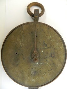 Kiewa Valley Historical Society
Tobacco Scales, Early 1900's
... bridge. arthur barnard. scales. rossaro. 0 - 250 numbers (by 10s) and measurements faintly inscribed around the edge of the plate. Iron circular plate attached to iron frame with rings attached to rings at both ends. 1 end facing frontwards and second end facing sideways. At 1 end is a back to front iron S formed as a hook. Attached to the middle of the plate is a very thin and sharp pointer. The plate is attached to a rectangular iron solid rectangle. Used to weigh ...Tobacco farming began circa 1960 in the Kiewa Valley and consequently became one of its major industries. Many of the italian families were involved in tobacco farming. These scales were bought from Arthur Barnard in 1962.Historical: Tobacco farming began circa 1960 in the Kiewa Valley and consequently became one of its major industries. Many of the Italian families were involved in tobacco farming. Provenance: This tobacco farmer came from Italy and was sponsored to visit a tobacco farmer in Myrtleford to learn how to grow tobacco so that he could transfer those skills to his own farm in the Kiewa Valley.Iron circular plate attached to iron frame with rings attached to rings at both ends. 1 end facing frontwards and second end facing sideways. At 1 end is a back to front iron S formed as a hook. Attached to the middle of the plate is a very thin and sharp pointer. The plate is attached to a rectangular iron solid rectangle. Used to weigh leaf when bailing.0 - 250 numbers (by 10s) and measurements faintly inscribed around the edge of the plate.tobacco. kiewa valley. mongans bridge. arthur barnard. scales. rossaro. -
 Eltham District Historical Society Inc
Photograph - Digital Photograph, Marguerite Marshall, Eltham Community and Reception Centre, 2 October 2006
... weigh more than 22kg. As a result the mud-bricks were redesigned to reduce their weight and were laid back-to-back to produce a wall of normal thickness.3 The centre’s massive timber frame is reminiscent of timber bridge construction, with infill panels of mud-brick.4 In accord with the rustic style are colossal rough-sawn posts, bolts and steel brackets. ...weigh more than 22kg. As a result the mud-bricks were redesigned to reduce their weight and were laid back-to-back to produce a wall of normal thickness.3 The centre’s massive timber frame is reminiscent of timber bridge construction, with infill panels of mud-brick.4 In accord with the rustic style are colossal rough-sawn posts, bolts and steel brackets. ...The Eltham Community and Reception Centre was Australia's first public mud-brick building. Commissioned in 1977 by Eltham Shire Council, led by Shire president (and architect) Robert Marshall, architects Whitford and Peck were asked to design a multipurpose facility in mud-brick and timber. The official opening was performed by the Hon. R.J. Hamer; E.D., M.P., Premier of Victorai on Saturday, April 22, 1978. Architects: Whitford & Peck Pty Ltd Quantity Surveyor: D.J. Cant & Associates Structural Civil Engineers: Charlett & Moore Pty Ltd Landscape: Peter Glass, Dennis Edwards Mech Elec: Lobley Treidel & Partners Pty Ltd Acoustics: Riley Barden & Kirkhope Builder: L.U. Simon Pty Ltd Covered under Heritage Overlay, Nillumbik Planning Scheme. Published: Nillumbik Now and Then / Marguerite Marshall 2008; photographs Alan King with Marguerite Marshall.; p177 The Wiggles performed there, so has the ABC’s Play School. New citizens have made their vows, volunteers have been honoured, school children have performed, weddings celebrated and people mourned at funerals. Since 1978 the Eltham Community and Reception Centre at the corner of Pitt Street and Main Road, has provided a beautiful and quintessential Eltham environment for people from all over Melbourne. Recognised as Australia’s first public mud-brick building, the centre was built partly on the site of the parsonage of the former Methodist Church (now the Uniting Church).1 Commissioned by the Eltham Council headed by President Robert Marshall, architects Whitford and Peck were asked to design a multipurpose facility in mud-brick and timber. Following public consultation, it was agreed to build a centre for dances, exhibitions, films, plays or concerts. The results – at a cost of around $620,000 – captured the Eltham rustic style. The building – in soft tones of mud-brick and timber and immense floor-to-ceiling windows – overlooks the Diamond Creek and sporting fields. Eltham’s strong artistic heritage is reflected in the centre. Although the lighting is not ideal for a gallery and labels cannot be placed on walls, the centre hosts the Nillumbik Art Awards and displays around ten to 20% of the Nillumbik Shire Art Collection, usually for around a year at a time.2 On permanent display, close to the entrance, is local artist Clifton Pugh’s White Choughs in the Landscape. Further to the right is the Walter Withers Gallery, named after a local member of the Heidelberg School of artists. As part of the Eltham Gateway opposite the Eltham Hotel, the centre stands on what was once part of the Eltham Town Centre along this section of Main Road, then known as Maria Street. On the same site once stood the house and flour mill owned by Henry Dendy, best known as the founder of Brighton, although he lived longer in Eltham. Beside the drive is a wheel-rim tool with accompanying plaque, illustrating a technology important during the horse-powered age and now almost completely gone, as has the blacksmith’s shop that had housed it nearby. The implement is a platform for fitting iron tyres to the wooden rims of cartwheels. Beneath it is a capsule placed in 1985 to commemorate Victoria’s 150 years, which is to be opened in 2035. Although the plants, forming part of the landscaping by Peter Glass and Denis Edwards, are largely indigenous and other native species, some exotic plants are protected as an important link with the site’s past. Planted at the front around 1920, is a large Peppercorn tree with two joined trunks growing from the base, and close by is a Bhutan Cypress (Cupressus torulosa). Three other Peppercorn trees fringe the drive. The building includes two halls – the larger seating 250 people – and a large foyer overlooking trees and ovals. Both halls have retractable rear walls providing varying spaces as required, and guests can use several external decks. A site for outdoor theatre has been carved out of the natural slope outside the entrance. The Bricklayers Union refused to use the traditional mud-bricks, which weigh more than 22kg. As a result the mud-bricks were redesigned to reduce their weight and were laid back-to-back to produce a wall of normal thickness.3 The centre’s massive timber frame is reminiscent of timber bridge construction, with infill panels of mud-brick.4 In accord with the rustic style are colossal rough-sawn posts, bolts and steel brackets. The combination of mud-brick, exposed feature timber framing and creative design in this centre, characterises Eltham’s innovative buildings and the social movement behind them from the 1940s to the 1970s.This collection of almost 130 photos about places and people within the Shire of Nillumbik, an urban and rural municipality in Melbourne's north, contributes to an understanding of the history of the Shire. Published in 2008 immediately prior to the Black Saturday bushfires of February 7, 2009, it documents sites that were impacted, and in some cases destroyed by the fires. It includes photographs taken especially for the publication, creating a unique time capsule representing the Shire in the early 21st century. It remains the most recent comprehenesive publication devoted to the Shire's history connecting local residents to the past. nillumbik now and then (marshall-king) collection, eltham community and reception centre, mudbrick construction -
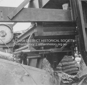 Eltham District Historical Society Inc
Album - Photograph, J.A. McDonald, Yarra Glen-Glenburn Road, June 1957
... Eltham District Historical Society Inc 728 Main Rd Eltham melbourne Jehosophat Creek – 56M295 June 1957 Weigh batcher in operation Record of various Shire of Eltham infrastructure works undertaken during the period of 1952-1962 involving bridge and road reconstruction projects, sometimes with Eltham Shire Council Project Reference numbers quoted. ...Jehosophat Creek – 56M295 June 1957 Weigh batcher in operationRecord of various Shire of Eltham infrastructure works undertaken during the period of 1952-1962 involving bridge and road reconstruction projects, sometimes with Eltham Shire Council Project Reference numbers quoted. It was during this period that a number of significant improvements were made to roads and new bridges constructed within the shire that remain in place as of present day (2022). In many situations, the photos provide a tangible visible record of infrastructure that existed throughout the early days of the Shire. The album was put together by or under the direction of the Shire Engineer, J.A. McDonald.infrastructure, shire of eltham, bridge construction, jehosophat creek, road construction, yarra glen-glenburn road, 1957-06 -
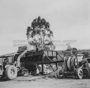 Eltham District Historical Society Inc
Album - Photograph, J.A. McDonald, Yarra Glen-Glenburn Road, June 1957
... Eltham District Historical Society Inc 728 Main Rd Eltham melbourne Jehosophat Creek – 56M295 June 1957 Loading weigh batcher deck pour Record of various Shire of Eltham infrastructure works undertaken during the period of 1952-1962 involving bridge and road reconstruction projects, sometimes with Eltham Shire Council Project Reference numbers quoted. ...Jehosophat Creek – 56M295 June 1957 Loading weigh batcher deck pourRecord of various Shire of Eltham infrastructure works undertaken during the period of 1952-1962 involving bridge and road reconstruction projects, sometimes with Eltham Shire Council Project Reference numbers quoted. It was during this period that a number of significant improvements were made to roads and new bridges constructed within the shire that remain in place as of present day (2022). In many situations, the photos provide a tangible visible record of infrastructure that existed throughout the early days of the Shire. The album was put together by or under the direction of the Shire Engineer, J.A. McDonald.infrastructure, shire of eltham, bridge construction, jehosophat creek, road construction, yarra glen-glenburn road, 1957-06 -
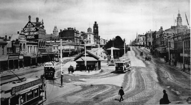 Ballarat Tramway Museum
Photograph - Black & White Photograph/s, 1913
... Ballarat Tramway Museum South Gardens Reserve Wendouree Parade Ballarat Ballarat goldfields Yields information the streetscape at the bottom of Sturt St, near Grenville St, the ESCo shelter and how the trams used the track, though in this case, the same tram appears three times. tramways trams Sturt St Grenville St Bridge St ESCo tram 5 Black and White copy photograph of a photograph of the Grenville tram terminus, in Sturt St, featuring the buildings on either side of Sturt St. Has the ESCo shelter at the bottom of the street, which dates from 1907 (Page 49 of "The Golden City and its tramways"). Note that a weighing ...Yields information the streetscape at the bottom of Sturt St, near Grenville St, the ESCo shelter and how the trams used the track, though in this case, the same tram appears three times.Black and White copy photograph of a photograph of the Grenville tram terminus, in Sturt St, featuring the buildings on either side of Sturt St. Has the ESCo shelter at the bottom of the street, which dates from 1907 (Page 49 of "The Golden City and its tramways"). Note that a weighing machine appears to be on the north side of the shelter. The photograph features three trams, that appear to be the same tram, No. 5. It has a "Stop tram at Harry Davies" roof advertisement sign. Also features the "Sutton Pianos organs and music" sign. Also a number of people crossing the street.tramways, trams, sturt st, grenville st, bridge st, esco, tram 5 -
 Broadmeadows Historical Society & Museum
Photograph - Road - Ring Road, Construction of the Jacana Underpass, c. 1990s
... bridging methods impractical. The tunnel was constructed using a pioneering hydraulic jacking technique, where precast concrete tunnel segments, each weighing approximately 1200 tonnes, were pushed into place through pilot tunnels. ...bridging methods impractical. The tunnel was constructed using a pioneering hydraulic jacking technique, where precast concrete tunnel segments, each weighing approximately 1200 tonnes, were pushed into place through pilot tunnels. ...This photograph documents the construction of the Jacana Underpass Tunnel, a landmark infrastructure project undertaken to allow Melbourne’s Western Ring Road to pass beneath a complex transport corridor. The corridor included Pascoe Vale Road, Electric Street, and four active railway lines—two broad gauge, one standard gauge, and one commuter line—making traditional tunneling or bridging methods impractical. The tunnel was constructed using a pioneering hydraulic jacking technique, where precast concrete tunnel segments, each weighing approximately 1200 tonnes, were pushed into place through pilot tunnels. This method minimised disruption to the busy transport corridor above, which carried tens of thousands of vehicles and multiple rail services daily. The Jacana Underpass Tunnel was constructed between 1992 and 1993 as part of Melbourne’s Western Ring Road project, a major infrastructure initiative aimed at improving traffic flow and connectivity across the city’s northern suburbs. The underpass was designed to carry the freeway beneath a complex transport corridor that included Pascoe Vale Road, Electric Street, and four active railway lines—two broad gauge, one standard gauge, and one commuter line. Due to the shallow depth of cover—less than one metre in some areas—and the need to maintain uninterrupted road and rail services above, engineers employed an innovative hydraulic jacking technique. This involved pushing precast concrete tunnel segments, each weighing approximately 1200 tonnes, through pilot tunnels using hydraulic rams. The method was one of the largest of its kind in Australia at the time and allowed for the safe and efficient installation of the tunnel without open excavation. The photograph captures a key stage in the construction process, showing the dual tunnel portals, heavy machinery, and construction materials on site. It reflects the scale, complexity, and ingenuity of late 20th-century civil engineering in Victoria and provides valuable insight into the evolution of Melbourne’s transport infrastructure.This photograph documents a pivotal moment in the construction of the Jacana Underpass Tunnel, part of Melbourne’s Western Ring Road infrastructure project undertaken in the early 1990s. The image features two tunnel entrances under construction, surrounded by heavy machinery, construction materials, and temporary fencing, with a dirt access road leading into the site. The Jacana Underpass was constructed using a hydraulic jacking technique, a method that allowed large precast concrete tunnel segments—each weighing approximately 1200 tonnes—to be installed beneath a live transport corridor without disrupting traffic or rail services. This innovative approach was one of the largest of its kind in Australia and addressed significant engineering challenges, including shallow cover and complex geological conditions. The photograph is significant for its documentation of advanced civil engineering practices and the transformation of Melbourne’s northern suburbs through major infrastructure development. It provides insight into the construction techniques, site logistics, and material use typical of large-scale tunneling projects in the late 20th century. As part of an archival collection, this image contributes to the historical record of urban growth, transport planning, and engineering innovation in Victoria. It holds enduring value for researchers, historians, and infrastructure professionals studying the evolution of public works in the state.Colour photo. Construction Site. Jacana underpass tunnel.(Back - blue pen) 'Underpass/Jacana'underpass, jacana, construction, 1990's, jacana underpass tunnel, western ring road -
 Wodonga & District Historical Society Inc
Photograph - Construction of Wodonga Creek Bridge, 1920
... The new concrete bridge was a little more than 500 feet long and consisted of 12 spans. The decking was supported by a number of steel girders, each weighing approximately seven tons. ...The new concrete bridge was a little more than 500 feet long and consisted of 12 spans. The decking was supported by a number of steel girders, each weighing approximately seven tons. ...The bridge over Wodonga Creek was opened on Friday 20th October 1922 by the Minister For Public Works Mr Frank. The erection of the bridge was carried out by Mr L Carr, of Brighton. The new concrete bridge was a little more than 500 feet long and consisted of 12 spans. The decking was supported by a number of steel girders, each weighing approximately seven tons. The whole bridge was supported by rows of three cylinders, sunk to a depth of 26ft below the summer water level. The original estimated cost of the structure was £20,000, but with the extras added during construction this amount was exceeded.These photos are significant because the capture the construction of an important bridge between Albury and Wodonga.Three black and white photographs taken during the construction of the new bridge over the Wodonga Creek in 1920.wodonga bridges, wodonga creek -
 Melton City Libraries
Newspaper, Bill was a pioneer, 1989
... There would be a quarter of a mile without exaggeration wagons and teams would be waiting to get into the mill, they would come down at the weighbridge at about 3-4- o’clock, 2 o’clock waiting for the bridge to open to weigh their loads, the ones that would be running late would be there at the weighbridge about half past 7 - 8 o’clock. ...There would be a quarter of a mile without exaggeration wagons and teams would be waiting to get into the mill, they would come down at the weighbridge at about 3-4- o’clock, 2 o’clock waiting for the bridge to open to weigh their loads, the ones that would be running late would be there at the weighbridge about half past 7 - 8 o’clock. ...Bill Cahill in conversation at Victoria Hall Melton South July 1974 Chaff Mills Melton’s hey day, as I call it in the days when more hay was grown in Melton and Rockbank than, I’d say in any where in Victoria. We had two chaff mills. If I can remember rightly I’m sure of this, that in one month the amount of hay and chaff that went from Melton to Melbourne was about 1800 tons, that’s hay and chaff. There was a lot of hay went from the Melton Railway Station. I have often seen whole train load going down the Schutt and Barrie, that’s Bonnie’s father’s mill at West Footscray. The mills in those days employed up to from 18- 20 men in each, that was before electricity when the mills were run on steam then, there was no power. At times those chaff mills they got a lot of shipping orders, to the Philipines and other Asian countries. They’d work shifts at night on the second shift at night time they would have an old hurricane lamp hanging above from the ceiling just over the chaff cutter, you could hardly see yourself, or see the anything. Well they worked through the whole night they might have an order come in for perhaps 100tons up 500 tons of chaff to go a boat would be in and be waiting to be loaded in Melbourne and they’d have to go and work two shifts. Then they brought in casual labour to help them through and get the order cut and get it down by rail to ship board to send it away. Talking about the hay I’ve seen wagons of hay in the farmers carting to both mills and also hay going down to West Footscray. There would be a quarter of a mile without exaggeration wagons and teams would be waiting to get into the mill, they would come down at the weighbridge at about 3-4- o’clock, 2 o’clock waiting for the bridge to open to weigh their loads, the ones that would be running late would be there at the weighbridge about half past 7 - 8 o’clock. They would be lucky to get away by night before getting their load off. A funny episode I remember well was a farmer from up, Alan Hurley you would remember him, Sam McCorkell he would put on his load in the afternoon or evening leave it up the yard, and would leave Toolern Vale about 12 or 1 o’clock in the morning and he would get down to the weighbridge and when it was breaking day he would bring half of his fowl yard down with him. The fowls would hop up on top of the load and have a ride down and when it came daylight they’d hop off and away they’d go, and I suppose everybody had some of McCorkells poultry. [laughter from the audience] That always tickled my fancy and everybody would be laughing about the fowls getting off his load of hay. I reckon that was about one of the funniest things I’ve ever heard of. The Victoria Hall, where we are tonight was originally known as the Exford Hall. I believe Bonnie’s father was the original builder and owner of the chaff mills here round the corner which is known as Wards today. Later on I understand that his father had a chaff mill here were this hall is, then Dixon Bros were just a bit on the other side. I believe Bonnie’s father sold it to Dixon Bros, and they shifted this part of the mill here and took it over and joined it up. That’s the history of the early chaff mills. Is that right Bonnie? You might like to correct, I’m about right am I? Bonnie answers yes. The original audio tape was recorded on the reel to reel tape recorder by Bon Barrie using his own tape recorder. Transferred to CD by Tom Wood using computer technology capable of adjusting the recording to a legible speed for reproduction to compact disk. Bill Cahill article featured in the The Mail Expresslocal identities