Showing 4550 items matching "wells road"
-
 Chelsea & District Historical Society Inc
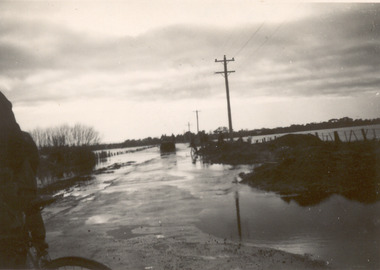
Photograph - Chelsea Flood December 1934, Wells Road, Chelsea
... Wells Road, Chelsea...Three Black and white photo of flood waters across Wells Road, Chelsea. A SEC truck can be see travelling down Wells Road in photo one and two, with people viewing the flooded street....Wells Road, Chelsea Photograph Chelsea Flood December 1934 ...In December 1934, 700 houses were inundated with water, when the Dandenong Creek and Patterson River broke their banks.Three Black and white photo of flood waters across Wells Road, Chelsea. A SEC truck can be see travelling down Wells Road in photo one and two, with people viewing the flooded street.flood, chelsea, dandenong creek, nepean highway, point nepean road -
 Chelsea & District Historical Society Inc
Photograph - Chelsea Flood December 1934, Wells Road and Thames Promenade
... Wells Road and Thames Promenade...Black and white photo taken from Wells Road looking down Thames Promenade, Chelsea....Wells Road and Thames Promenade Photograph Chelsea Flood December 1934 ...In December 1934, 700 houses were inundated with water, when the Dandenong Creek and Patterson River broke their banks.Black and white photo taken from Wells Road looking down Thames Promenade, Chelsea.flood, chelsea, dandenong creek, fowler street, sherwood avenue -
 Kingston Arts
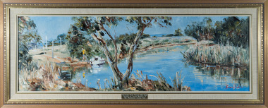
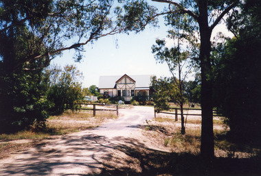
Painting, Margery Fitzgerald Boyle, Mordialloc Creek Towards Wells Road, 1976
... Mordialloc Creek Towards Wells Road...Kingston Arts 979 Nepean Hwy (Cnr South Road and Nepean Hwy, 100 metres from Moorabbin train station) Moorabbin melbourne Mordialloc Creek Towards Wells Road Painting Margery Fitzgerald Boyle ... -
 Chelsea & District Historical Society Inc
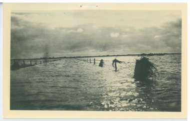
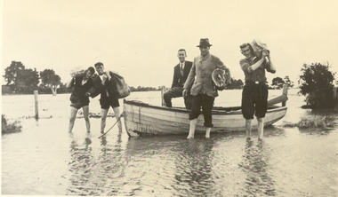
Photograph - Chelsea Flood December 1934, Delivering Food
... ...Wells Road...Black and white photo of five men in a life boat delivering rations to flood victims, landing at Wells Road. One of the men is Livock....Chelsea & District Historical Society Inc The Chelsea Activity Hub 3-5 Showers Ave Chelsea 3196 melbourne In December 1934, 700 houses were inundated with water, when the Dandenong Creek and Patterson River broke their banks. flood chelsea Dandenong Creek Wells Road Black and white photo of five men in a life boat delivering rations to flood victims, landing at Wells Road. ...In December 1934, 700 houses were inundated with water, when the Dandenong Creek and Patterson River broke their banks.Black and white photo of five men in a life boat delivering rations to flood victims, landing at Wells Road. One of the men is Livock.flood, chelsea, dandenong creek, wells road -
 City of Moorabbin Historical Society (Operating the Box Cottage Museum)
Flyer - Outstanding Auction Sales, 1957
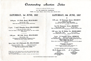
... ...33 Wells Road Beaumaris...Example of the progress of the Municipality of Moorabbin Ormond 33 Wells Road Beaumaris 7 & 9 Douglas Street Beaumaris 100 Oak Street Beaumaris 5 & 6 Balcombe Road Beaumaris 34 Tennyson Street Highett 13 Leopold St Ormond Lot 93 Tennyson Street Highett Lot 52 Delma St Moorabbin Auction Real Estate Saturday 1 June 1957 - 4 properties for sale in Beaumaris - Saturday 8 June 1957 - 4 properties for sale in Highett (x2), Moorabbin, Ormond Advertising flyer for outstanding Auction Sales in the estate of Charles McCarthy Stott (1870-1956). ...Sale of property of the estate of Charles McCarthy Stott, a local estate agent. Example of the progress of the Municipality of MoorabbinAdvertising flyer for outstanding Auction Sales in the estate of Charles McCarthy Stott (1870-1956).Saturday 1 June 1957 - 4 properties for sale in Beaumaris - Saturday 8 June 1957 - 4 properties for sale in Highett (x2), Moorabbin, Ormondormond, 33 wells road beaumaris, 7 & 9 douglas street beaumaris, 100 oak street beaumaris, 5 & 6 balcombe road beaumaris, 34 tennyson street highett, 13 leopold st ormond, lot 93 tennyson street highett, lot 52 delma st moorabbin, auction, real estate -
 Glen Eira Historical Society
Letter - Third Church Of Christ, Scientist, Elsternwick
... Road... Wells Mr... Overton A E Little Hazel Mrs Elsternwick Glen Huntly Road Wells Mr Ripon Grove Foundation Stones Riley David Eddy Mary Baker Church Of Christ Scientist Dispensary Hall Selwyn Street. ...3 documents and a photograph photocopy of Third Church Of Christ, Scientist, Elsternwick. The first one is a document that provides a brief history of the Third Church Of Christ Scientist Melbourne. Includes notes on the building, principles and association with the mother church in Boston Massachusets. Second is a note of the inscription on the foundation stone of the church. Third is a letter from Mrs Hazel Little to Mr Wells concerning Mr Wells request for a brief history of the church. Attached in the letter is brief history and a photo of the church. The last one is a photograph photocopy of the Third Church Of Scientist which was opened in 1931.masonic hall, williams louis r., architecture, st georges road, overton a e, little hazel mrs, elsternwick, glen huntly road, wells mr, ripon grove, foundation stones, riley david, eddy mary baker, church of christ scientist, dispensary hall, selwyn street., religious group, church, third church of christ scientist elsternwick, third church of christ scientist melbourne. -
Glen Eira Historical Society
Document - ‘KENLY’, Gladstone Parade, 34, Elsternwick
... Road... Wells Andrew...Includes a brief history of owners and tenants from 1888 to 1941 and a description of its architectural features as well as a black and white exterior photograph. 2/Two colour exterior photographs dated 13/10/2011 Gladstone Parade Elsternwick ‘Kenly’ House Names 21-Aug-18 Mansions Hume C. Kooyong Park Estate Clarence Street Jackson Thomas B. Shoobra Road ...This file contains two items about this property: 1/Photocopy of Caulfield conservation study on ‘Kenly’ (1899) completed by Andrew Ward in October 1994. Includes a brief history of owners and tenants from 1888 to 1941 and a description of its architectural features as well as a black and white exterior photograph. 2/Two colour exterior photographs dated 13/10/2011gladstone parade, elsternwick, ‘kenly’, house names, 21-aug-18, mansions, hume c., kooyong park estate, clarence street, jackson thomas b., shoobra road, wells andrew, ford grylls, langwill p., henriques fred, pearson alfred, edmends james, williamson alfred, caulfield, ward andrew, architectural styles, victorian style, verandahs, brick houses, windows -
 Coal Creek Community Park & Museum
Mine Map, 21/01/1945
... 6298.1 - Map of Coal Creek mine tunnels, coal seams, boreholes, as well as roads and coal leura creeks....Coal Creek Community Park & Museum 12 Silkstone Road Korumburra gippsland 6298.1 - Map of Coal Creek mine tunnels, coal seams, boreholes, as well as roads and coal leura creeks. ...6298.1 - Map of Coal Creek mine tunnels, coal seams, boreholes, as well as roads and coal leura creeks. -
 Coal Creek Community Park & Museum
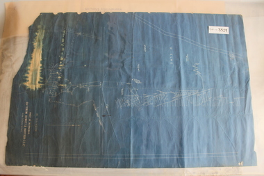
Outtrim Blueprint, Part Of Workings
... 8519.1 - Blueprint of mine tunnels at Outtrim, as well as surface roads and boreholes....Coal Creek Community Park & Museum 12 Silkstone Road Korumburra gippsland 8519.1 - Blueprint of mine tunnels at Outtrim, as well as surface roads and boreholes. ...8519.1 - Blueprint of mine tunnels at Outtrim, as well as surface roads and boreholes. -
 Lakes Entrance Historical Society
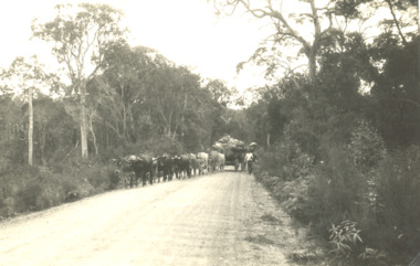
Photograph - Bullock Wagon, East Gippsland Victoria, 2005c
... Black and white photograph showing team of fourteen bullocks pulling a wagon load of produce with driver walking at side on wide and well maintained road, tall thick forest either side, East Gippsland Victoria...Lakes Entrance Historical Society 4 Marine Parade Lakes Entrance gippsland Agriculture Transport Black and white photograph showing team of fourteen bullocks pulling a wagon load of produce with driver walking at side on wide and well maintained road, tall thick forest either side, East Gippsland Victoria East Gippsland Victoria Photograph Bullock Wagon ...Black and white photograph showing team of fourteen bullocks pulling a wagon load of produce with driver walking at side on wide and well maintained road, tall thick forest either side, East Gippsland Victoriaagriculture, transport -
 Whitehorse Historical Society Inc.
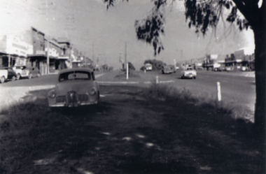
Photograph, Mitcham - 1952, c1952
... Black and white photograph of Mitcham shopping centre looking east from Edward Street - although it was only a two lane road at Mitcham, Whitehorse Road had its service roads well developed. Note the early Holden in the foreground...Whitehorse Historical Society Inc. 2-10 Deep Creek Road Mitcham melbourne Sent to a parishioner at Christ Church Mitcham, by Phyllis Grant who lived at the Migrant Hostel in Mitcham in 1952-54, where her husband did development work under the P.M.G. whitehorse road mitcham holden grant phyllis Black and white photograph of Mitcham shopping centre looking east from Edward Street - although it was only a two lane road at Mitcham, Whitehorse Road had its service roads well developed. Note the early Holden in the foreground Mitcham - 1952 Photograph Photograph ...Sent to a parishioner at Christ Church Mitcham, by Phyllis Grant who lived at the Migrant Hostel in Mitcham in 1952-54, where her husband did development work under the P.M.G.Black and white photograph of Mitcham shopping centre looking east from Edward Street - although it was only a two lane road at Mitcham, Whitehorse Road had its service roads well developed. Note the early Holden in the foregroundwhitehorse road, mitcham, holden, grant, phyllis -
Bendigo Historical Society Inc.
Document - National Trust Collection: Former Conrad Heinze Butcher's Shop, 1872
... Data Forms on the house on Corner of Happy Valley Road and Wells Street, Long Gully, now demolished. ...It was demolished about 1982. history National Trust Bendigo Collection bendigo Happy Valley Road Long Gully Butcher's Shop Bendigo Conrad Heinze Data Forms on the house on Corner of Happy Valley Road and Wells Street, Long Gully, now demolished. ...Source National Trust: Conrad Heinz Butchers Shop - Happy Valley Road. This building was a weatherboard cottage evidently built in three stages with the front door in the central part, planked by three paned double casements, six-paned sash windows in the rear section; front section and timber veradah with scrolled vallance. The architect and builders are unknown. The outside doors to the cellar and the simple chimney breast remain a notable feature. The original owner was Conrad Heinz a former mayor of Bendigo who with two brothers opened a butcher's shop in the building in 1872. In 1883 he moved to Mt Korong Road Iron Bark, where he carried on another thriving business and built a substantial house close by. When Conrad Heinz left Happy Valley Road, one brother had died, but his widow carried on the first butchering business with the help of a lad and one of her three daughters. The little shop and residence stood for over a century on the spot, almost untouched by modern progress. The shop was closed for 70 years at most. It was demolished about 1982.Data Forms on the house on Corner of Happy Valley Road and Wells Street, Long Gully, now demolished. Various letters to and between the Bendigo Council, the National Trust and the owners of the house.history, national trust bendigo collection, bendigo, happy valley road long gully, butcher's shop bendigo, conrad heinze -
 Wonga Park Community Cottage History Group
Document - List of Attendees and Well wishers, of Yarra road Primary School 25th anniversary celebrations
... Lists of Attendees and Well Wishers of Yarra Road Primary School 25th anniversary celebrations...Wonga Park Community Cottage History Group Unit 1, 9 – 13 Old Yarra Road Wonga Park melbourne Lists of Attendees and Well Wishers of Yarra Road Primary School 25th anniversary celebrations of Yarra road Primary School 25th anniversary celebrations Document List of Attendees and Well wishers ...Lists of Attendees and Well Wishers of Yarra Road Primary School 25th anniversary celebrations -
 Eltham District Historical Society Inc
Photograph, Well in front of Living and Learning Centre, Eltham, 1992, 1992
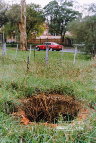
... well now covered up and site redeveloped. Was originally located just north of the entrance to the Living and Learning Centre which is now the location of present-day commercial premises at 739 Main Road. ...Perspective showing well with Main Road and Eltham Hotel in background 2. ...Perspective showing well with Main Road and Eltham Hotel in background 2. ...Original well now covered up and site redeveloped. Was originally located just north of the entrance to the Living and Learning Centre which is now the location of present-day commercial premises at 739 Main Road. In the distant background on the other side of Main Road can be seen the Eltham Hotel in its pink days.Two colour photographs of a well which remains on vacant land at front of Living and Learning Centre, Eltham. 1. Perspective showing well with Main Road and Eltham Hotel in background 2. Looking into the bottle shaped well which is approx. 3m deep and 2m diameterwells, eltham, living and learning centre, main road, eltham hotel -
 Flagstaff Hill Maritime Museum and Village
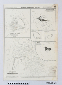
Document - Navigation Chart, Islands in the North Pacific (Western Hawaiian Group)
... British Admiralty Navigation Chart - Islands in the North Pacific (Western Hawaiian Group) : Midway Islands, Seward Road and Welles Harbour, Necker Island, Cure or Ocean Island, Pearl and Hermes Reef...Flagstaff Hill Maritime Museum and Village 89 Merri Street Warrnambool great-ocean-road warrnambool shipwrecked-coast flagstaff-hill flagstaff-hill-maritime-museum maritime-museum shipwreck-coast flagstaff-hill-maritime-village shipwrecked-artefact navigation chart british admiralty navigation chart midway islands Islands in the North Pacific (Western Hawaiian Group) Seward Road Welles Harbour Necker Island Cure or Ocean Island Pearl and Hermes Reef British Admiralty Navigation Chart - Islands in the North Pacific (Western Hawaiian Group) : Midway Islands, Seward Road and Welles Harbour, Necker Island, Cure or Ocean Island, Pearl and Hermes Reef Islands in the North Pacific (Western Hawaiian Group) Document Navigation Chart ...British Admiralty Navigation Chart - Islands in the North Pacific (Western Hawaiian Group) : Midway Islands, Seward Road and Welles Harbour, Necker Island, Cure or Ocean Island, Pearl and Hermes Reefwarrnambool, shipwrecked-coast, flagstaff-hill, flagstaff-hill-maritime-museum, maritime-museum, shipwreck-coast, flagstaff-hill-maritime-village, shipwrecked-artefact, navigation chart, british admiralty navigation chart, midway islands, islands in the north pacific (western hawaiian group), seward road, welles harbour, necker island, cure or ocean island, pearl and hermes reef -
 Lakes Entrance Historical Society
Photograph - Housing, Tudor dwelling at Colqhuoun Road. Lakes Entrance 1999
... Road. Corrugated iron gable roof across building. Gable roofed projection centre front. Dark painted lathes on outer walls add to Tudor effects. Set well...Road. Corrugated iron gable roof across building. Gable roofed projection centre front. Dark painted lathes on outer walls add to Tudor effects. Set well ...Built late 1970's or early 1980's by Roger Simpson, cabinet maker. Internal space originally had large banquet hall in centre, surrounded by kitchen and utilities, bedrooms upstairs overlooking hall. It has since been modified.Colour photograph of a mock Tudor dwelling at Colqhuoun Road. Corrugated iron gable roof across building. Gable roofed projection centre front. Dark painted lathes on outer walls add to Tudor effects. Set well back from road with established garden. Lakes Entrance Victoriahouses, architecture -
 Bendigo Historical Society Inc.
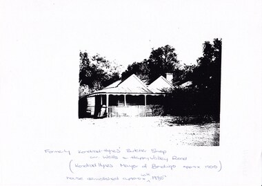
Photograph - LONG GULLY HISTORY GROUP COLLECTION: KONRAD HYNES' BUTCHER SHOP
... Written under the photo is: Formerly Konrad Hynes' Butcher Shop cnr. Wells and Happy Valley Road. (Konrad Hynes Mayor of Bendigo approx 1900). ...Written under the photo is: Formerly Konrad Hynes' Butcher Shop cnr. Wells and Happy Valley Road. (Konrad Hynes Mayor of Bendigo approx 1900). ...2 copies of a black and white photo of Konrad Hynes' Butcher Shop. Written under the photo is: Formerly Konrad Hynes' Butcher Shop cnr. Wells and Happy Valley Road. (Konrad Hynes Mayor of Bendigo approx 1900). House demolished approx. late 1980.bendigo, history, long gully history group, the long gully history group - konrad hynes' butcher shop -
 Surrey Hills Historical Society Collection
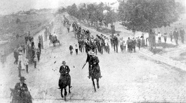
Photograph, Parade in celebration of King Edward VII's birthday, 1902, 1902
... The area to the left is blurry but would be the railway line and station surrounds. Roads are well formed with bluestone channels....The area to the left is blurry but would be the railway line and station surrounds. Roads are well formed with bluestone channels. Parade in celebration of King Edward VII's birthday, 1902 Photograph ...The parade was held in celebration of King Edward VII's birthday on 4 July 1902. This was the first public appearance of the German Band formed on 30 May 1902. The leading horseman is Mr Rowland Coe. He is followed by Mr George Robinson, a butcher of Canterbury Road. The man in the white hat is Mr Sam Kellett, businessman of Erasmus Street. Behind him on foot and partly obscured is Mr Alexander McNeill of the Surrey Family Hotel. Band master is Harry Pollard, painter and paper-hanger, and next to him is Constable Hill. The small boy in the sailor suit is Perc Venman of Essex Road and in the buggy near the footpath is Mr and Mrs William Maling. Information came from David Staig senior. Further research: William Saunders Maling, a son of John Butler Maling, was a builder who lived at 17 Balwyn Road, Canterbury. Rowland Coe, a butcher and son of James and Elizabeth Coe of Sunbury Crescent enlisted in AIF in WW1. He later lived at 233 Elgar Road, Box Hill. William Percival Reginald (Perc) Venman was born in Surrey Hills in 1894; he died in Surrey Hills in 1951 and lived at 27 Essex Street for much of his life. He and his wife are buried in Box Hill Cemetery. The identity of Sam Kellett of Erasmus Street is questioned. Edward Kellett built 'Yielma' in Erasmus Street but was deceased by 1902. He had 3 sons: Edward Allan (1854-1932); George Henry (1858-1921) and William John (1865-1945).Black and white photo of a number of men on horses leading a parade down Station Street (Windsor Crescent) to Union Road. Street trees on the RHS are mature whilst the ones on the LHS look to be newly planted. They have wooden guards around them. The area to the left is blurry but would be the railway line and station surrounds. Roads are well formed with bluestone channels.parades and processions, bands, german band, windsor crescent, william saunders maling, mrs hannah maling, miss hannah miller, constable hill, perc venman, george robinson, sam kellett, alexander mcneill, rowland coe, harry pollard, william percival reginald venman -
 Kiewa Valley Historical Society
Papers - Kiewa Hydro Electric Scheme, State Electricity Commission of Victoria / Kiewa Hydro Electric Project / Progress of the Undertaking, November 1953
... It included work on Power Stations, Dams, Tunnels, Race-lines and transmission lines as well as camps, towns, roads, telecommunications and infra structure. ...It included work on Power Stations, Dams, Tunnels, Race-lines and transmission lines as well as camps, towns, roads, telecommunications and infra structure. ...The SECV constructed the KHES from 1939 to 1961 on the Bogong High Plains. It included work on Power Stations, Dams, Tunnels, Race-lines and transmission lines as well as camps, towns, roads, telecommunications and infra structure. These papers give an understanding of where the project was up to in late 1953. These papers give information on the KHES on the aspects of work, its progress and technical detail.3 foolscap pages, stapled in the top left hand corner. Each page has sub headings re the progress of the works being undertaken on the Kiewa Hydro Electric Scheme.state electricity commission of victoria; kiewa hydro electric scheme; power stations; dams; tunnels; bogong high plains -
 Falls Creek Historical Society
Clothing - Cycling Shirt - McKayos Mountain Bike Ride, 2016
... The back features the words SNOW, DIRT, ROAD as well as sponsors' logos and "Falls Creek Victoria and the manufacturer, Sacul Sportswear of Mount Beauty, Victoria. ...The back features the words SNOW, DIRT, ROAD as well as sponsors' logos and "Falls Creek Victoria and the manufacturer, Sacul Sportswear of Mount Beauty, Victoria. ...In 2015, the Marketing, Events, and Operations teams at Falls Creek launched McKayos—a bold, one-of-a-kind race designed to showcase the resort's trails to winter visitors. Inspired by the legendary Megavalanche in the French Alps, McKayos was a mass-start descent from the summit of Mt McKay (1,850m) to the edge of Lake Bogong, over 1,200m below. Riders tackled snow, village roads, fire trails, and singletrack across an 18km course. With the support of the Lift Company, competitors and bikes were transported up the Falls Express chairlift before climbing to the summit start line. In later years, the race began at the Ski Patrol base. Held for five consecutive years, McKayos grew to attract up to 450 participants, cementing itself as a legendary event in Australian mountain biking history. This shirt is from the 2016 event when the winners were:- Open Men: Paul van der Ploeg (1st), Sebastian Jayne (2nd). Women: Lisa Brydon (1st), Julia Clark (2nd) Junior Men: Ben McIlroy (1st) Casey Griska (2nd) Jo Prothero, Director of Marketing for Falls Creek Resort Management from 2012 to 2019, generously donated two mountain bike jerseys that capture a pivotal era in the resort's history. During Jo's tenure, the resort made significant investments in mountain bike trails, aiming to activate the village during the summer months and support local businesses. This development included appointing Blue Dirt as the resort's first shuttle operator, transporting riders from Howman's Gap to the Summit.This shirt is significant because it represents an important and innovative event held at Falls Creek Victoria.A green and gold cyclist shirt featuring the logo of the McKayos Mountain Bike Ride. It also has a mountain bike on the front in black. The Mckayos logo in on the upper left. The back features the words SNOW, DIRT, ROAD as well as sponsors' logos and "Falls Creek Victoria and the manufacturer, Sacul Sportswear of Mount Beauty, Victoria. McKayos is on the right sleeve and 2016 is on the left sleeve.mckayos mountain bike ride, falls creek activities, falls creek victoria -
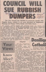 Bendigo Historical Society Inc.
Newspaper - VICTORIA HILL - RUBBISH DUMPERS AT VICTORIA HILL
... Article mentions that the City Council has decided to prosecute people who illegally dump rubbish in an area bounded by Eaglehawk Marong and Happy Valley Roads and Wells Street. Rubbish had been dumped there despite the prohibiting signs. ...Article mentions that the City Council has decided to prosecute people who illegally dump rubbish in an area bounded by Eaglehawk Marong and Happy Valley Roads and Wells Street. Rubbish had been dumped there despite the prohibiting signs. ...Newspaper article from the Bendigo Advertiser dated 8/5/68. Article mentions that the City Council has decided to prosecute people who illegally dump rubbish in an area bounded by Eaglehawk Marong and Happy Valley Roads and Wells Street. Rubbish had been dumped there despite the prohibiting signs. Numerous notices have been served on the people responsible for dumping the rubbish.newspaper, bendigo advertiser, victoria hill, rubbish dumpers at victoria hill, bendigo advertiser 8/5/68, bendigo city council, mr k j shearn -
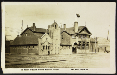 Mission to Seafarers Victoria
Postcard - Postcard, Sepia, Valentines Real Photo Series, The Missions to Seamen Institute, Melbourne Victoria, c. 1922
... It demonstrates a lack of urban surrounds or buildings as well as a paved road and a horse-drawn wagon. The figure in the photo is also a record of the dress style of the era. ...It demonstrates a lack of urban surrounds or buildings as well as a paved road and a horse-drawn wagon. The figure in the photo is also a record of the dress style of the era. ...This postcard depicts the urban setting of the Mission to Seafarers a few years after its construction. (the Dome, the last part erected, was opened on 21 October 1921). It demonstrates a lack of urban surrounds or buildings as well as a paved road and a horse-drawn wagon. The figure in the photo is also a record of the dress style of the era. The lady is most likely a member of the Ladies' Harbour Lights Guild.This postcard demonstrates that the building was deemed important enough to be photographed for a postcard. It is a record of what the Mission to Seafarers looked like two years after its construction, and its urban surrounding.Sepia postcard of the Mission to Seafarers building complex and surrounding streets. The postcard depicts a wagon and a woman walking by the complex wearing a black dress and coat and black hat and holding an umbrella. Front: THE MISSIONS TO SEAMEN INSTITUTE, MELBOURNE VICTORIA REAL PHOTO SERIES.M.1696 Reverse: PUBLISHED BY THE VALENTINE & SONS PUBLISHING CO.LTD / MELBOURNE SYDNEY & BRISBANE. Contains logo of VALENTINES REAL PHOTO SERIES POSTCARD. Stamp logo lists: BRANCHES / SYDNEY / LONDON / DUNDEE / DUBLIN / CAPETOWN / MONTREAL / TORONTO Handwritten in blue: 1919mission to seafarers, melbourne, mission to seamen, seamen's mission, norla dome, flag, flying angel, lady, horse cart, umbrella, flinders street extension, ships, australian wharf, valentine's postcards, real photo series postcards, st peter chapel, lhlg, architecture, walter richmond butler -
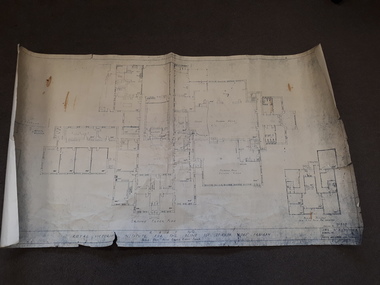 Vision Australia
Plan - Image, RAAF HQ Royal Victorian Institute for the Blind, 14/3/1942
... Dale)Works Director Air Services show the layout of the main building at 557 St Kilda Road as well as that of the babies nursery. Doorways, cupboards and stairwells are annotated in this carbon copy, as well as the layout of Ormond Hall....Dale)Works Director Air Services show the layout of the main building at 557 St Kilda Road as well as that of the babies nursery. Doorways, cupboards and stairwells are annotated in this carbon copy, as well as the layout of Ormond Hall. ...In 1942, the expansion of the war into the Pacific expanded wartime operations in Australia and some of the RVIB buildings were comandeered for house military staff. This plan, drawn up in March 1942 by J.G. and authorised by the Superintending Architect and (W. Dale)Works Director Air Services show the layout of the main building at 557 St Kilda Road as well as that of the babies nursery. Doorways, cupboards and stairwells are annotated in this carbon copy, as well as the layout of Ormond Hall.1 architectural plan of St Kilda Road layoutmyer house, royal victorian institute for the blind, plans, raaf -
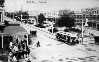 Ballarat Tramway Museum
Photograph - copy of postcard - Sturt St Ballarat
... A number of horse drawn cabs and men and ladies - well dressed crossing the roads. The photograph also shows cabling on a telephone/telegraph line running directly in front of the photographer. ...A number of horse drawn cabs and men and ladies - well dressed crossing the roads. The photograph also shows cabling on a telephone/telegraph line running directly in front of the photographer. ...Black and White copy photograph of a Ballarat Municipal library (No. 947) postcard at the time of the opening of the Electric tramway in Ballarat. Photo taken in 1905. Photo taken from the Town Hall with Snows building in the foreground and other buildings on the north side of Sturt St in the background. A number of horse drawn cabs and men and ladies - well dressed crossing the roads. The photograph also shows cabling on a telephone/telegraph line running directly in front of the photographer. See 8419 and 8999 for the postcard and a printed illustration.Yields information about the opening configuration of the trams and the street scene at the corner of Sturt and Armstrong Streets. Also shows a number of well dressed people walking along Sturt St.Copy photograph of a postcard held by the Ballarat Municipal Library - see also item 8419sturt st, armstrong st, esco, tramways, ballarat, tramcars -
 Eltham District Historical Society Inc
Slide, Reconstruction of Grand Boulevard viewed from Panorama Avenue, Montmorency, 18 August 1970, 1970
... Road at Montmorency was purchased in 1969. In 1970, Eltham Shire Council undertook roadworks to construct Apex Way in preparation for the new station as well as duplicate Main Road, Lower Plenty, east of Grand Boulevard including the new Lower Plenty Bridge, which had been opened in November 1966, bordering with the City of Heidelberg....Road at Montmorency was purchased in 1969. In 1970, Eltham Shire Council undertook roadworks to construct Apex Way in preparation for the new station as well as duplicate Main Road, Lower Plenty, east of Grand Boulevard including the new Lower Plenty Bridge, which had been opened in November 1966, bordering with the City of Heidelberg. 1970-08-18, Apex-Diamond Valley Ambulance Station, Eltham Ambulance Station, Eltham Apex Club, Grand Boulevard, Montmorency 35 mm colour positive transparency Mount - Agfacolor Service (Blue) Reconstruction of Grand Boulevard viewed from Panorama Avenue, Montmorency, 18 August 1970 Slide ...The Eltham Apex Club conducted a Community Service Project (1965-1968) to raise funds for a new Ambulance Station to service the community. A site bounded by the intersection of Main Road, Grand Boulevard and Looker Road at Montmorency was purchased in 1969. In 1970, Eltham Shire Council undertook roadworks to construct Apex Way in preparation for the new station as well as duplicate Main Road, Lower Plenty, east of Grand Boulevard including the new Lower Plenty Bridge, which had been opened in November 1966, bordering with the City of Heidelberg.35 mm colour positive transparency Mount - Agfacolor Service (Blue)1970-08-18, apex-diamond valley ambulance station, eltham ambulance station, eltham apex club, grand boulevard, montmorency -
 Eltham District Historical Society Inc
Slide, Construction of Apex Way between Looker Road and Grand Boulevard, Montmorency, 18 August 1970, 1970
... Road at Montmorency was purchased in 1969. In 1970, Eltham Shire Council undertook roadworks to construct Apex Way in preparation for the new station as well as duplicate Main Road, Lower Plenty, east of Grand Boulevard including the new Lower Plenty Bridge, which had been opened in November 1966, bordering with the City of Heidelberg....Road at Montmorency was purchased in 1969. In 1970, Eltham Shire Council undertook roadworks to construct Apex Way in preparation for the new station as well as duplicate Main Road, Lower Plenty, east of Grand Boulevard including the new Lower Plenty Bridge, which had been opened in November 1966, bordering with the City of Heidelberg. 1970-08-18, Apex-Diamond Valley Ambulance Station, Eltham Ambulance Station, Eltham Apex Club, Grand Boulevard, Looker Road, Montmorency 35 mm colour positive transparency Mount - Agfacolor Service (Blue) Construction of Apex Way between Looker Road and Grand Boulevard, Montmorency, 18 August 1970 Slide ...The Eltham Apex Club conducted a Community Service Project (1965-1968) to raise funds for a new Ambulance Station to service the community. A site bounded by the intersection of Main Road, Grand Boulevard and Looker Road at Montmorency was purchased in 1969. In 1970, Eltham Shire Council undertook roadworks to construct Apex Way in preparation for the new station as well as duplicate Main Road, Lower Plenty, east of Grand Boulevard including the new Lower Plenty Bridge, which had been opened in November 1966, bordering with the City of Heidelberg.35 mm colour positive transparency Mount - Agfacolor Service (Blue)1970-08-18, apex-diamond valley ambulance station, eltham ambulance station, eltham apex club, grand boulevard, looker road, montmorency -
 Eltham District Historical Society Inc
Photograph, Looking east along Main Road, Lower Plenty approaching the top of the hill and Grand Boulevard, July 1969, 1969
... Road at Montmorency was purchased in 1969. In 1970, Eltham Shire Council undertook roadworks to construct Apex Way in preparation for the new station as well as duplicate Main Road, Lower Plenty, east of Grand Boulevard including the new Lower Plenty Bridge, which had been opened in November 1966, bordering with the City of Heidelberg....Road at Montmorency was purchased in 1969. In 1970, Eltham Shire Council undertook roadworks to construct Apex Way in preparation for the new station as well as duplicate Main Road, Lower Plenty, east of Grand Boulevard including the new Lower Plenty Bridge, which had been opened in November 1966, bordering with the City of Heidelberg. ...The Eltham Apex Club conducted a Community Service Project (1965-1968) to raise funds for a new Ambulance Station to service the community. A site bounded by the intersection of Main Road, Grand Boulevard and Looker Road at Montmorency was purchased in 1969. In 1970, Eltham Shire Council undertook roadworks to construct Apex Way in preparation for the new station as well as duplicate Main Road, Lower Plenty, east of Grand Boulevard including the new Lower Plenty Bridge, which had been opened in November 1966, bordering with the City of Heidelberg.35mm colour positive transparency blue Agfacolour Service plastic mountambulance station, apex-diamond valley ambulance station, eltham ambulance station, eltham apex club, lower plenty, main road, montmorency -
 Ringwood and District Historical Society
Newspaper, Cutting from The Mail 25-3-1987 - death of Mr. Kevin Pratt a well known Ringwood resident
... Mr Pratt's Funeral service in Our Ladies Church in Bedford Road was well attended. See also photographs in Personalities...Mr Pratt's Funeral service in Our Ladies Church in Bedford Road was well attended. See also photographs in Personalities Newspaper article about Mr Kevin Pratt who died in 1987 Cutting from The Mail 25-3-1987 - death of Mr. ...Kevin Pratt was one of Ringwood's best known residents when he died at the age of 77 in 1987. An amputee from the age of three he overcame his own physical handicaps and went on to encourage and help the youth of the district. He was President of the Ringwood Football Club for 25 years. His memory is perpetuated by a pavillion in Mullum Reserve which bears his name. Mr Pratt's Funeral service in Our Ladies Church in Bedford Road was well attended. See also photographs in PersonalitiesNewspaper article about Mr Kevin Pratt who died in 1987 -
 Eltham District Historical Society Inc
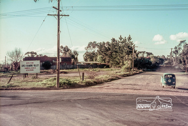
Slide, Site for the new Apex-Diamond Valley Ambulance Station, corner of Main Road and Looker Road, Montmorency, July 1969, 1969
... Road at Montmorency was purchased in 1969. In 1970, Eltham Shire Council undertook roadworks to construct Apex Way in preparation for the new station as well as duplicate Main Road, Lower Plenty, east of Grand Boulevard including the new Lower Plenty Bridge, which had been opened in November 1966, bordering with the City of Heidelberg....Road at Montmorency was purchased in 1969. In 1970, Eltham Shire Council undertook roadworks to construct Apex Way in preparation for the new station as well as duplicate Main Road, Lower Plenty, east of Grand Boulevard including the new Lower Plenty Bridge, which had been opened in November 1966, bordering with the City of Heidelberg. 1969-07, ambulance station, apex way, apex-diamond valley ambulance station, eltham ambulance station, looker road, lower plenty, main road, montmorency, Eltham Apex Club 35 mm colour positive transparency Mount - Agfacolor Service (Blue) Site for the new Apex-Diamond Valley Ambulance Station, corner of Main Road and Looker Road, Montmorency, July 1969 Slide ...Looking northwest from Main Road towards Looker Road at the new site for the Apex-Diamond Valley Ambulance Station before construction of Apex Way, July 1969. The Eltham Apex Club conducted a Community Service Project (1965-1968) to raise funds for a new Ambulance Station to service the community. A site bounded by the intersection of Main Road, Grand Boulevard and Looker Road at Montmorency was purchased in 1969. In 1970, Eltham Shire Council undertook roadworks to construct Apex Way in preparation for the new station as well as duplicate Main Road, Lower Plenty, east of Grand Boulevard including the new Lower Plenty Bridge, which had been opened in November 1966, bordering with the City of Heidelberg.35 mm colour positive transparency Mount - Agfacolor Service (Blue)1969-07, ambulance station, apex way, apex-diamond valley ambulance station, eltham ambulance station, looker road, lower plenty, main road, montmorency, eltham apex club -
 Eltham District Historical Society Inc
Slide, Site for the new Apex-Diamond Valley Ambulance Station, corner of Main Road and Grand Boulevard, Montmorency, July 1969, 1969
... Road at Montmorency was purchased in 1969. In 1970, Eltham Shire Council undertook roadworks to construct Apex Way in preparation for the new station as well as duplicate Main Road, Lower Plenty, east of Grand Boulevard including the new Lower Plenty Bridge, which had been opened in November 1966, bordering with the City of Heidelberg....Road at Montmorency was purchased in 1969. In 1970, Eltham Shire Council undertook roadworks to construct Apex Way in preparation for the new station as well as duplicate Main Road, Lower Plenty, east of Grand Boulevard including the new Lower Plenty Bridge, which had been opened in November 1966, bordering with the City of Heidelberg. 1969-07, ambulance station, apex way, grand boulevard, lower plenty, main road, montmorency, eltham ambulance station, apex-diamond valley ambulance station, Eltham Apex Club 35 mm colour positive transparency Mount - Agfacolor Service (Blue) Site for the new Apex-Diamond Valley Ambulance Station, corner of Main Road and Grand Boulevard, Montmorency, July 1969 Slide ...View looking west along Grand Boulevard from the intersection with Main Road and Panorama Avenue, Montmorency showing the site for the new Apex-Diamond Valley Ambulance Station and before construction of Apex Way, July 1969. The Eltham Apex Club conducted a Community Service Project (1965-1968) to raise funds for a new Ambulance Station to service the community. A site bounded by the intersection of Main Road, Grand Boulevard and Looker Road at Montmorency was purchased in 1969. In 1970, Eltham Shire Council undertook roadworks to construct Apex Way in preparation for the new station as well as duplicate Main Road, Lower Plenty, east of Grand Boulevard including the new Lower Plenty Bridge, which had been opened in November 1966, bordering with the City of Heidelberg.35 mm colour positive transparency Mount - Agfacolor Service (Blue)1969-07, ambulance station, apex way, grand boulevard, lower plenty, main road, montmorency, eltham ambulance station, apex-diamond valley ambulance station, eltham apex club