Showing 21 items matching "wellsford parish"
-
 Bendigo Historical Society Inc.
Map - CAMPBELL COLLECTION: BENDIGO AND DISTRICT MAPS
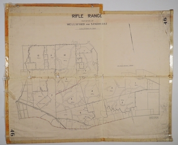
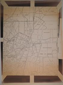
... ...Wellsford Parish...Rifle Range, Parishes of Wellsford and Sandhurst. Scale 20 chains to 1 inch. ...MAP Bendigo allotments Bendigo Rifle Range Sandhurst Parish Wellsford Parish H.A.D.(Darby). Map. Rifle Range, Parishes of Wellsford and Sandhurst. ...Map. Rifle Range, Parishes of Wellsford and Sandhurst. Scale 20 chains to 1 inch. Total area in plan is 5916 acres. Wallan and Bendigo Railway to Axedale Township and station 8 miles, to Longlea Railway Station 2 1/2 - 3 miles. Rifle Range. Compiled in W.P.B. from Assessment and Parish Plans, by H.A.D. 8-7-29H.A.D.(Darby).map, bendigo, allotments, bendigo rifle range, sandhurst parish, wellsford parish -
 Bendigo Historical Society Inc.
Map - CAMPBELL COLLECTION: BENDIGO AND DISTRICT MAPS
... Sandhurst and suburbs, Parish of Sandhurst, Parish of Huntly, Parish of Nerring, Parish of Marong, Parish of Lockwood, Parish of Wellsford, Parish of Strathfieldsaye, Parish of Mandurang...Sandhurst and suburbs, Parish of Sandhurst, Parish of Huntly, Parish of Nerring, Parish of Marong, Parish of Lockwood, Parish of Wellsford, Parish of Strathfieldsaye, Parish of Mandurang Map CAMPBELL COLLECTION: BENDIGO AND DISTRICT MAPS. ...Map. Sandhurst and suburbs, Parish of Sandhurst, Parish of Huntly, Parish of Nerring, Parish of Marong, Parish of Lockwood, Parish of Wellsford, Parish of Strathfieldsaye, Parish of Mandurangmap, bendigo, parishes -
 Bendigo Historical Society Inc.
Map - CAMPBELL COLLECTION: BENDIGO AND DISTRICT MAPS
... Parish of Sandhurst, Parish of Huntly, Parish of Nerring, Parish of Marong, Parish of Lockwood, Parish of Wellsford, Parish of Strathfieldsaye, Parish of Mandurang. ...Parish of Sandhurst, Parish of Huntly, Parish of Nerring, Parish of Marong, Parish of Lockwood, Parish of Wellsford, Parish of Strathfieldsaye, Parish of Mandurang. ...Map. Parish of Sandhurst, Parish of Huntly, Parish of Nerring, Parish of Marong, Parish of Lockwood, Parish of Wellsford, Parish of Strathfieldsaye, Parish of Mandurang. Scale approx 1:18,000.map, bendigo, parishes -
 Bendigo Historical Society Inc.
Map - CAMPBELL COLLECTION: BENDIGO & DISTRICT MAPS, 2-2-29
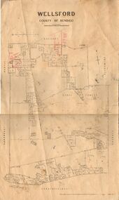
... Map. Wellsford, Parishes of Wellsford and Axedale. Scale 20 chains to 1 inch. ...History House 11 Mackenzie Street Bendigo goldfields MAP Bendigo country lands W.J.Galbraith Map. Wellsford, Parishes of Wellsford and Axedale. Scale 20 chains to 1 inch. ...Map. Wellsford, Parishes of Wellsford and Axedale. Scale 20 chains to 1 inch. Total area 4994 acres. Prepared in W.P.B. from A. and P. Plans by W.J.G. (number 377 in map cupboard 1)W.J.Galbraithmap, bendigo, country lands -
 Bendigo Historical Society Inc.
Map - JACK FLYNN COLLECTION: WELLSFORD, 2/11/1914
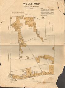
... ...parish plan...Wellsford...Map: Parish of Wellsford, County of Bendigo. Parish plan....Butson. 2-.11.14 Map: Parish of Wellsford, County of Bendigo. Parish plan. ...Map: Parish of Wellsford, County of Bendigo. Parish plan.Photo-Lithographed at the Department of Lands and Survey Melbourne By H.J. Butson. 2-.11.14map, bendigo, parish plan, wellsford -
Bendigo Historical Society Inc.
Map - CAMPBELL COLLECTION: BENDIGO AND DISTRICT MAPS, 2-2-29
... Map. Wellsford, Parishes of Wellsford and Axedale, Scale 20 chains to 1 inch. ...History House 11 Mackenzie Street Bendigo goldfields MAP Bendigo parish plan W.J.Galbraith Map. Wellsford, Parishes of Wellsford and Axedale, Scale 20 chains to 1 inch. ...Map. Wellsford, Parishes of Wellsford and Axedale, Scale 20 chains to 1 inch. Total area 4994 acres. Prepared in W.P.B. from A and P Plans, by W.J.G.2-2-29. Top left of map are directions to Fosterville, Huntly & Bendigo. (number 361 in map cupboard 1)W.J.Galbraithmap, bendigo, parish plan -
 Bendigo Historical Society Inc.
Map - JACK FLYNN COLLECTION: WELLSFORD, 15/12/1941
... ...parish plan...Wellsford...Map: Parish of Wellsford, County of Bendigo. Parish plan. 2 copies of the same plan....History House 11 Mackenzie Street Bendigo goldfields MAP Bendigo parish plan Wellsford Map: Parish of Wellsford, County of Bendigo. ...Map: Parish of Wellsford, County of Bendigo. Parish plan. 2 copies of the same plan.map, bendigo, parish plan, wellsford -
Bendigo Historical Society Inc.
Map - WELLSFORD, 15/10/1903
... ...parish plan...Wellsford...Map: Parish of Wellsford, County of Bendigo. Parish plan (number 321 in map cupboard 1)...History House 11 Mackenzie Street Bendigo goldfields MAP Bendigo parish plan Wellsford Map: Parish of Wellsford, County of Bendigo. ...Map: Parish of Wellsford, County of Bendigo. Parish plan (number 321 in map cupboard 1)map, bendigo, parish plan, wellsford -
 Bendigo Historical Society Inc.
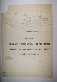
Map - BENDIGO IRRIGATION SETTLEMENT, 20/10/1908
... Map: Bendigo Irrigation Settlement, Parishes of Sandhurst and Wellsford, County of Bendigo, Parish plan...History House 11 Mackenzie Street Bendigo goldfields MAP Bendigo irrigation settlement Bendigo irrigation Settlement Map: Bendigo Irrigation Settlement, Parishes of Sandhurst and Wellsford, County of Bendigo, Parish plan Map BENDIGO IRRIGATION SETTLEMENT ...Map: Bendigo Irrigation Settlement, Parishes of Sandhurst and Wellsford, County of Bendigo, Parish planmap, bendigo, irrigation settlement, bendigo irrigation settlement -
Bendigo Historical Society Inc.
Map - WELLSFORD, 4/07/1876
... ...parish plan...Wellsford...Map: Parish of Wellsford, County of Bendigo. Strathfieldsaye, Wellsford , Bagshot (number 311 in map cupboard 1)...History House 11 Mackenzie Street Bendigo goldfields MAP Bendigo parish plan Wellsford Map: Parish of Wellsford, County of Bendigo. ...Map: Parish of Wellsford, County of Bendigo. Strathfieldsaye, Wellsford , Bagshot (number 311 in map cupboard 1)map, bendigo, parish plan, wellsford -
 Bendigo Historical Society Inc.
Map - CAMPBELL COLLECTION: BENDIGO AND DISTRICT MAPS
... Eastern area of Bendigo, Parish of Huntly, Ascot, Shire of Huntly, Jackass Flat, Old White Hills, White Hills, Emu Point, North Bendigo, East Bendigo, Strathdale, Parish of Strathfieldsaye, Parish of Sandhurst, Parish of Wellsford....Eastern area of Bendigo, Parish of Huntly, Ascot, Shire of Huntly, Jackass Flat, Old White Hills, White Hills, Emu Point, North Bendigo, East Bendigo, Strathdale, Parish of Strathfieldsaye, Parish of Sandhurst, Parish of Wellsford. Map CAMPBELL COLLECTION: BENDIGO AND DISTRICT MAPS. ...Map. Eastern area of Bendigo, Parish of Huntly, Ascot, Shire of Huntly, Jackass Flat, Old White Hills, White Hills, Emu Point, North Bendigo, East Bendigo, Strathdale, Parish of Strathfieldsaye, Parish of Sandhurst, Parish of Wellsford.map, bendigo, parishes -
Bendigo Historical Society Inc.
Map - CAMPBELL COLLECTION: BENDIGO AND DISTRICT MAPS, 8-2-29
... Map. Bagshot, Parishes of Wellsford, Ellesmere and Bagshot. Scale 20 chains to 1 inch. ...History House 11 Mackenzie Street Bendigo goldfields MAP Bendigo agricultural lands W.J.Galbraith Map. Bagshot, Parishes of Wellsford, Ellesmere and Bagshot. Scale 20 chains to 1 inch. ...Map. Bagshot, Parishes of Wellsford, Ellesmere and Bagshot. Scale 20 chains to 1 inch. Total area 5037 acres. Prepared in W.P.B. from A.C.l. and D.B. Plans, W.J. Galbraith, 8-2-29 (number 353 in map cupboard 1)W.J.Galbraithmap, bendigo, agricultural lands -
Bendigo Historical Society Inc.
Map - CAMPBELL COLLECTION: BENDIGO AND DISTRICT MAPS, 8-2-29
... Map. Bagshot, Parishes of Wellsford, Ellesmere, and Bagshot. Huntly 4 miles, Fosterville 3 miles. ...History House 11 Mackenzie Street Bendigo goldfields MAP Bendigo agricultural lands .W.J.Galbraith Map. Bagshot, Parishes of Wellsford, Ellesmere, and Bagshot. Huntly 4 miles, Fosterville 3 miles. ...Map. Bagshot, Parishes of Wellsford, Ellesmere, and Bagshot. Huntly 4 miles, Fosterville 3 miles. Total area 5037 acres, Prepared in W.P.B. from A.C.L and D.B. Plans, by W.J.Galbraith 8-2-29. (number 382 in map cupboard 1).W.J.Galbraithmap, bendigo, agricultural lands -
 Bendigo Historical Society Inc.
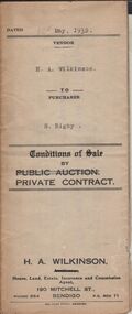
Document - H.A. & S.R. WILKINSON COLLECTION: CONDITION OF SALE
... Rigby (buyer) for land within the special settlement area situate Junortoun containing 17 acres, 1 rood, 27 perches being allotment 37F Parish of Wellsford, County of Bendigo described in Crown grant volume 4485 folio 896958, together with 4-roomed weatherboard dwelling and all sundry. ...Rigby (buyer) for land within the special settlement area situate Junortoun containing 17 acres, 1 rood, 27 perches being allotment 37F Parish of Wellsford, County of Bendigo described in Crown grant volume 4485 folio 896958, together with 4-roomed weatherboard dwelling and all sundry. ...BHS CollectionConditions of sale by private contract dated 12th May, 1932 between H.A. Wilkinson (seller) and S. Rigby (buyer) for land within the special settlement area situate Junortoun containing 17 acres, 1 rood, 27 perches being allotment 37F Parish of Wellsford, County of Bendigo described in Crown grant volume 4485 folio 896958, together with 4-roomed weatherboard dwelling and all sundry. Price 575 pounds.organization, business, h.a. & s.r wilkinson real estate -
Bendigo Historical Society Inc.
Map - CAMPBELL COLLECTION: BENDIGO AND DISTRICT MAPS, 8-7-29
... Rifle Range, Parishes of Wellsford and Sandhurst. Scale 20 chains to 1 inch. ...Rifle Range, Parishes of Wellsford and Sandhurst. Scale 20 chains to 1 inch. ...Map. Rifle Range, Parishes of Wellsford and Sandhurst. Scale 20 chains to 1 inch. Total area by Planimeter 5916 acres. Wallan and Bendigo Railway line. Rifle Range. Axedale township and station 8 miles. To Longlea Ryl station 2 1/2 miles. To Epsom 1 1/2 miles. To Bendigo 3 miles. Compiled in W.P.D. from Assessment and Parish Plans by H.A.D 8-7- 29 (number 367 in map cupboard 1)H.A.D.(H.A.Darby)map, bendigo, allotments -
Bendigo Historical Society Inc.
Map - BENDIGO IRRIGATION SETTLEMENT, 12/02/1908
... Map: Plan of Bendigo Irrigation Settlement, Parishes of Sandhurst and Wellsford, County of Bendigo ( number 160 in Map Cupboard 1)...History House 11 Mackenzie Street Bendigo goldfields MAP Bendigo irrigation settlement Bendigo Irrigation Settlement Parishes of Sandhurst and Wellsford County of Bendigo Map: Plan of Bendigo Irrigation Settlement, Parishes of Sandhurst and Wellsford, County of Bendigo ( number 160 in Map Cupboard 1) Map BENDIGO IRRIGATION SETTLEMENT ...Map: Plan of Bendigo Irrigation Settlement, Parishes of Sandhurst and Wellsford, County of Bendigo ( number 160 in Map Cupboard 1)map, bendigo, irrigation settlement, bendigo irrigation settlement, parishes of sandhurst and wellsford, county of bendigo -
 Bendigo Historical Society Inc.
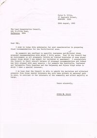
Document - PETER ELLIS COLLECTION: LETTER, 20th August, 1980
... Wellsford Forest... Mandurang Forest... Main Coliban Channel... Lockwood Forest... Waanyaras... Fryerstown... Whipstick Hill (Flagstaff Hill)... Parish...History House 11 Mackenzie Street Bendigo goldfields PERSON Individual peter ellis oam Peter Ellis Collection Land Conservation Council Kamarooka State park Whipstick State park Eucalyptus Oil Production FNCV Victorian Naturalist D J Paton Bendigo Field Naturalists Club Wellsford Forest Mandurang Forest Main Coliban Channel Lockwood Forest Waanyaras Fryerstown Whipstick Hill (Flagstaff Hill) Parish of Neilborough Old Underground Water Race Puddling Machine SRWSC Letter (11 Pages) from Peter N Ellis to the Land Conservation Council. ...Letter (11 Pages) from Peter N Ellis to the Land Conservation Council. Letter refers to proposed State parks - Kamarooka State Park and Whipstick State Park. other areas mentioned are the Wellsford Forest, Mandurang Forest, Lockwood Forest, Waanyaraa, Fryerstown, Whipstick Hill (Flagstaff Hill) and Black Rock. Other areas are Wellsford/Axedale Forest, Sugarloaf Range, Mandurang Forest, Main Coliban Channel, Lockwood Forest, Tarnagulla/Dunolly Forest, Fryerstown, Seven Sisters (between Huntly and Goornong). Plant and tree life in each area is mentioned including the cutting of eucalypt for the production of Eucalyptus oil.person, individual, peter ellis oam, peter ellis collection, land conservation council, kamarooka state park, whipstick state park, eucalyptus oil production, fncv victorian naturalist, d j paton, bendigo field naturalists club, wellsford forest, mandurang forest, main coliban channel, lockwood forest, waanyaras, fryerstown, whipstick hill (flagstaff hill), parish of neilborough, old underground water race, puddling machine, srwsc -
Bendigo Historical Society Inc.
Map - BENDIGO AND DISTRICT PARISH MAPS, 21-10-26
... Wellsford. By Authority H.J. Green, Government Printer, Photo-Lithographed at the Department of Lands and Survey, Melbourne bj W.J Butson 21-10-26,Price 1/-. (number 13 in map cupboard 1) Map BENDIGO AND DISTRICT PARISH ...Map. Sandhurst, County of Bendigo, City of Bendigo, Strathfieldsaye, Mandurang, Marong, Nerring, Borough of Eaglehawk, Township of Kangaroo Flat, Lockwood, Huntly, Epsom, Wellsford. By Authority H.J. Green, Government Printer, Photo-Lithographed at the Department of Lands and Survey, Melbourne bj W.J Butson 21-10-26,Price 1/-. (number 13 in map cupboard 1)By Authority H.J. Green, Govt. Printermap, bendigo, sandhurst -
Bendigo Historical Society Inc.
Map - PARISH OF STRATHFIELDSAYE : COUNTY OF BENDIGO, 1-10-19
... Parish of Strathfieldsaye, County of Bendigo, Wellsford, Sandhurst, Sedgwick, Eppalock, Axedale. ...Parish of Strathfieldsaye, County of Bendigo, Wellsford, Sandhurst, Sedgwick, Eppalock, Axedale. ...Map. Parish of Strathfieldsaye, County of Bendigo, Wellsford, Sandhurst, Sedgwick, Eppalock, Axedale. Photo-Lithographed at the Department of Lands and Survey, Melbourne by W.J.Butson, 1-10-19. Price 1/-. By authority A.J. Mullett, Government Printer, Melbourne. (number 34 in map cupboard 1)A.J. Mullett, Govt. Printer, Melbourne.map, bendigo, strathfieldsaye -
Bendigo Historical Society Inc.
Map - CAMPBELL COLLECTION: BENDIGO AND DISTRICT MAPS, 12-2-29
... Axedale, Parishes of Ellesmere and Axedale. Scale 20 chains to 1 inch. To the west is Wellsford. ...Axedale, Parishes of Ellesmere and Axedale. Scale 20 chains to 1 inch. To the west is Wellsford. ...Map. Axedale, Parishes of Ellesmere and Axedale. Scale 20 chains to 1 inch. To the west is Wellsford. Total area 4156 acres. Prepared in W.P.B. from A and P plans by W.J. Galbraith 12-2-29. (number 352 in map cupboard 1)W.J.Galbraithmap, bendigo, agricultural lands -
Bendigo Historical Society Inc.
Map - CAMPBELL COLLECTION: BENDIGO AND DISTRICT MAPS
... Ascot, Parishes of Huntly, Sandhurst and Wellsford. Scale 20 chains to 1 inch. ...Ascot, Parishes of Huntly, Sandhurst and Wellsford. Scale 20 chains to 1 inch. ...Map. Ascot, Parishes of Huntly, Sandhurst and Wellsford. Scale 20 chains to 1 inch. Total area 2818 acres. To Bendigo 4 1/2 miles, to Epsom 3/4 mile, Huntly 3/4 mile. Prepared in W.P.B. from Assessment Plans and Parish Plans. (number 380 in map cupboard 1)map, bendigo, agricultural lands