Showing 343 items matching "west bank"
-
 Brimbank City Council Art Collection
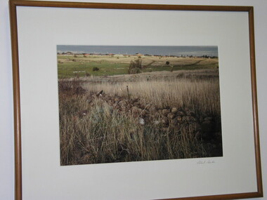
Photograph, Robert Pointon, West Bank of Kororoit Creek, 1988
... West Bank of Kororoit Creek...West Bank of Kororoit Creek - AR0033...Brimbank City Council Art Collection The Hunt Club Community Arts Centre 775 Ballarat Road Deer Park melbourne Local Scene West Bank of Kororoit Creek - AR0033 West Bank of Kororoit Creek Photograph Robert Pointon ...Local SceneWest Bank of Kororoit Creek - AR0033 -
 Brimbank City Council Art Collection
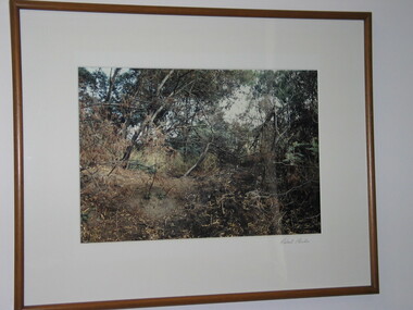
Photograph, Robert Pointon, West Bank of Maribyrnong River, North Sunshine, 1987
... West Bank of Maribyrnong River, North Sunshine...West Bank of Maribyrnong River, North Sunshine - AR0034...Brimbank City Council Art Collection The Hunt Club Community Arts Centre 775 Ballarat Road Deer Park melbourne Local Scene West Bank of Maribyrnong River, North Sunshine - AR0034 West Bank of Maribyrnong River, North Sunshine Photograph Robert Pointon ...Local SceneWest Bank of Maribyrnong River, North Sunshine - AR0034 -
 Brimbank City Council Art Collection
Photograph, Robert Pointon, West Bank of the Kororoit Creek looking north, 1988
... West Bank of the Kororoit Creek looking north...Huntsman Chemical works, West Bank of the Kororoit Creek looking north - AR0019...Brimbank City Council Art Collection The Hunt Club Community Arts Centre 775 Ballarat Road Deer Park melbourne Local Scene Huntsman Chemical works, West Bank of the Kororoit Creek looking north - AR0019 West Bank of the Kororoit Creek looking north Photograph Robert Pointon ...Local SceneHuntsman Chemical works, West Bank of the Kororoit Creek looking north - AR0019 -
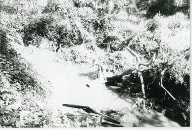
 Eltham District Historical Society Inc
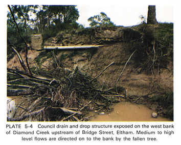
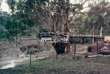
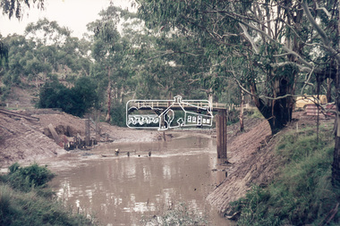
Work on paper (Sub-Item) - Photograph, Council drain and drop structure exposed on the west bank of Diamond Creek upstream of Bridge Street, Eltham
... Council drain and drop structure exposed on the west bank of Diamond Creek upstream of Bridge Street, Eltham...Colour photograph of a muddy creek (probably after a downpour) showing council drain and drop structure exposed on the west bank of Diamond Creek upstream of Bridge Street, Eltham. ...Eltham District Historical Society Inc 728 Main Rd Eltham melbourne Colour photograph of a muddy creek (probably after a downpour) showing council drain and drop structure exposed on the west bank of Diamond Creek upstream of Bridge Street, Eltham. ...Colour photograph of a muddy creek (probably after a downpour) showing council drain and drop structure exposed on the west bank of Diamond Creek upstream of Bridge Street, Eltham. Mediun to high level water flows are directed on to the bank by the fallen tree.eltham, creek, diamond creek, bridge street, drainage, waterflow, vegetation -
 Wodonga & District Historical Society Inc
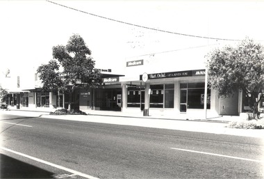
Photograph - Codling Collection 01 - Wodonga, High Street West - Gas company, State Bank, Medicare and Black Orchid, 1980s
... Codling Collection 01 - Wodonga, High Street West - Gas company, State Bank, Medicare and Black Orchid...Codling Collection 01 - Wodonga, High Street West - Gas company, State Bank, Medicare and Black Orchid...Wodonga, High Street West Businesses including Gas company, ESANDA, State Bank of Victoria, Toyworld, Medicare, Black Orchid Gift and Hostess Store, and the Royal Bank. ...The Royal Bank (National Mutual Royal Bank) later merged with ANZ. Codling Collection 01 - Wodonga, High Street West - Gas company, State Bank, Medicare and Black Orchid Photograph Codling Collection 01 - Wodonga, High Street West - Gas company, State Bank, Medicare and Black Orchid ...Miss Olive Codling was a Foundation Member and a Life Member of the Wodonga Historical Society. Many of her prize-winning photos are held in the Society Collection. She also held a range of roles and committee positions in a wide range of Wodonga community organisations. These included the Horticultural Society, the Wodonga Arts Council, the Wodonga Camera Club and the Wodonga Lapidary Club. This photo collection is significant as it documents how the businesses and buildings in Wodonga have evolved and contributed to community throughout the 20th century.Wodonga, High Street West Businesses including Gas company, ESANDA, State Bank of Victoria, Toyworld, Medicare, Black Orchid Gift and Hostess Store, and the Royal Bank. The State Bank of Victoria was taken over by the Commonwealth Bank in 1990. The Medicare service was removed from Wodonga in 2015 and amalgamated with the Albury Service Centre. The Royal Bank (National Mutual Royal Bank) later merged with ANZ. wodonga businesses, high st wodonga, state bank, medicare wodonga, royal bank -
 Eltham District Historical Society Inc
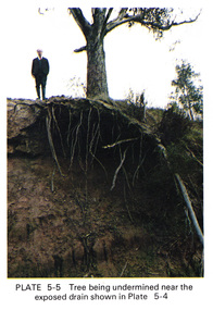
Work on paper (Sub-Item) - Photograph, Tree being undermined near an exposed drain on the west bank of Diamond Creek upstream of Bridge Street, Eltham
... Tree being undermined near an exposed drain on the west bank of Diamond Creek upstream of Bridge Street, Eltham...The tree has been undermined with roots exposed near a council drain. eltham diamond creek bridge street drainage roots tree Image printed on A4 page from 04997 Diamond Creek Basin Study, 1980 Tree being undermined near an exposed drain on the west bank of Diamond Creek upstream of Bridge Street, Eltham Work on paper Photograph ...Colour photograph of tree on the side of the Diamond Creek upstream at Bridge Street, Eltham. The tree has been undermined with roots exposed near a council drain.eltham, diamond creek, bridge street, drainage, roots, tree -
 Eltham District Historical Society Inc
Slide, Construction of new bridge, looking downstream from west bank towards existing Lintons Bridge across Arthurs Creek, Doctors Gully Road, Nutfield, 22 February 1972, 1972
... Construction of new bridge, looking downstream from west bank towards existing Lintons Bridge across Arthurs Creek, Doctors Gully Road, Nutfield, 22 February 1972...Eltham District Historical Society Inc 728 Main Rd Eltham melbourne arthurs creek, bridge construction, doctors gully road, eltham shire council, infrastructure, lintons bridge, nutfield 35 mm colour positive transparency Mount - Agfacolor Service (Blue) Construction of new bridge, looking downstream from west bank towards existing Lintons Bridge across Arthurs Creek, Doctors Gully Road, Nutfield, 22 February 1972 Slide ...35 mm colour positive transparency Mount - Agfacolor Service (Blue)arthurs creek, bridge construction, doctors gully road, eltham shire council, infrastructure, lintons bridge, nutfield -
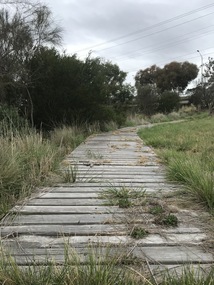 Sunshine and District Historical Society Incorporated
Photograph - Lions Club Reserve Kororoit Creek Deer Park Photographs, John Alchin, 2021
... Situated on the west bank of the Kororoit Creek, it lies directly opposite the Deer Park Hotel, where a swimming hole once enjoyed popularity among the early residents of Deer Park. ...5651.01 - Lions Club Reserve Kororoit Creek West Bank Deer Park 2021 Photo 23.JPG 5651.02 - Lions Club Reserve Kororoit Creek West Bank Deer Park 2021 Photo 17.JPG 5651.03 - Lions Club Reserve Kororoit Creek West Bank Deer Park 2021 Photo 19.JPG 5651.04 - Lions Club Reserve Kororoit Creek West Bank Deer Park 2021 Photo 20.JPG 5651.05 - Lions Club Reserve Kororoit Creek West Bank Deer Park 2021 Photo 21.JPG ...Ballarat Road Deer Park Kororoit Creek Deer Park Lions Club 5651.01 - Lions Club Reserve Kororoit Creek West Bank Deer Park 2021 Photo 23.JPG 5651.02 - Lions Club Reserve Kororoit Creek West Bank Deer Park 2021 Photo 17.JPG 5651.03 - Lions Club Reserve Kororoit Creek West Bank Deer Park 2021 Photo 19.JPG 5651.04 - Lions Club Reserve Kororoit Creek West Bank Deer Park 2021 Photo 20.JPG 5651.05 - Lions Club Reserve Kororoit Creek West Bank Deer Park 2021 Photo 21.JPG Digital Photographs Photograph Lions Club Reserve Kororoit Creek Deer Park Photographs John Alchin ...No formal name has been assigned to this reserve. From research, which is still to be confirmed, it is believed the Deer Park Lions Club installed the infrastructure in the area, which includes the wooden path, table and bench seat, therefore for convenience we will refer to it as the Lions Club Reserve. Situated on the west bank of the Kororoit Creek, it lies directly opposite the Deer Park Hotel, where a swimming hole once enjoyed popularity among the early residents of Deer Park. Unfortunately, as the surrounding areas were developed for residential and industrial requirements, along came pollution that made these holes unsafe to swim in. The use of these holes were discouraged in the mid 1900's and subsequently the local Councils of the district started to provide man made swimming pools such as the ones located in Sunshine and St. Albans. Today, now an almost forgotten location in Deer Park, the water hole provides a tranquil location for visitors to relax and watch the creek slowly flowing past and the birdlife that frequent the area.Water holes along the Kororoit Creek and Maribyrnong River were once used for providing drinking water, relaxation, recreation sport and spots to cool off on the long summer days.5651.01 - Lions Club Reserve Kororoit Creek West Bank Deer Park 2021 Photo 23.JPG 5651.02 - Lions Club Reserve Kororoit Creek West Bank Deer Park 2021 Photo 17.JPG 5651.03 - Lions Club Reserve Kororoit Creek West Bank Deer Park 2021 Photo 19.JPG 5651.04 - Lions Club Reserve Kororoit Creek West Bank Deer Park 2021 Photo 20.JPG 5651.05 - Lions Club Reserve Kororoit Creek West Bank Deer Park 2021 Photo 21.JPG ballarat road, deer park, kororoit creek, deer park lions club -
 Ringwood and District Historical Society
Photograph, ANZ Bank "West End" Branch, Ringwood, before Ringwood Market Re-development, c1979
... ANZ Bank "West End" Branch, Ringwood, before Ringwood Market Re-development, c1979...Ringwood and District Historical Society 125A Warrandyte Road Ringwood North melbourne Colour photographs taken by Richard Carter, c1979 ANZ Bank "West End" Branch, Ringwood, before Ringwood Market Re-development, c1979 Photograph ...Colour photographs taken by Richard Carter, c1979 -
 Brimbank City Council Art Collection
Photograph, Robert Pointon, John's Knife, 1988
... John's Knife - West bank of the Maribyrnong River facing south, colour photograph, ...Brimbank City Council Art Collection The Hunt Club Community Arts Centre 775 Ballarat Road Deer Park melbourne Local Scene John's Knife - West bank of the Maribyrnong River facing south, colour photograph, John's Knife Photograph Robert Pointon ...Local SceneJohn's Knife - West bank of the Maribyrnong River facing south, colour photograph, -
 Tatura Irrigation & Wartime Camps Museum
Photograph, Goulburn Weir, 1890
... Concrete and iron weir structure, stone spillway, earth bank on West bank below brick control house. Dead trees in water beyond weir, houses on West bank...Concrete and iron weir structure, stone spillway, earth bank on West bank below brick control house. Dead trees in water beyond weir, houses on West bank Goulburn Weir Photograph ...Taken by photographer for State Rivers and Water Supply Commission.Medium sized black and white photograph. Concrete and iron weir structure, stone spillway, earth bank on West bank below brick control house. Dead trees in water beyond weir, houses on West bankgoulburn weir, victorian state rivers and supply commission -
 Ringwood and District Historical Society
Photograph, Mullum Mullum Creek on 29th Oct 1989, north bank 100m west of Harrison Street, Unknown date
... Mullum Mullum Creek on 29th Oct 1989, north bank 100m west of Harrison Street...Ringwood and District Historical Society 125A Warrandyte Road Ringwood North melbourne Digital photograph Mullum Mullum Creek on 29th Oct 1989, north bank 100m west of Harrison Street Photograph ...Digital photograph -
 Bendigo Historical Society Inc.
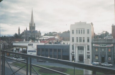
Photograph - EDITH LUNN COLLECTION: PHOTO LOOKING WEST FROM THE BENDIGO BANK BOARD ROOM, TOWARDS BUILDINGS AT CHARING CROSS, AND THE SACRED HEART CATHEDRAL, 27/07/1995
... EDITH LUNN COLLECTION: PHOTO LOOKING WEST FROM THE BENDIGO BANK BOARD ROOM, TOWARDS BUILDINGS AT CHARING CROSS, AND THE SACRED HEART CATHEDRAL...Photographs taken from Bendigo Bank Board Room, towards the west of period buildings on Charing Cross, including the Sacred Heart Cathedral and Post Office. 9A Looking west from Board Room towards Sacred Heart Cathedral. 9B Alexandra Fountain, Charing Cross and Rosalind Park. ...Photograph EDITH LUNN COLLECTION: PHOTO LOOKING WEST FROM THE BENDIGO BANK BOARD ROOM, TOWARDS BUILDINGS AT CHARING CROSS, AND THE SACRED HEART CATHEDRAL ...Photographs taken from Bendigo Bank Board Room, towards the west of period buildings on Charing Cross, including the Sacred Heart Cathedral and Post Office. 9A Looking west from Board Room towards Sacred Heart Cathedral. 9B Alexandra Fountain, Charing Cross and Rosalind Park. View looking towards View Street. Note old Infant Welfare Centre on the corner of View Street and Pall Mall. 9C Looking north along Pall Mall towards Post Office with Rosalind Park to the left facing west. 9D Looking north down Pall Mall with former in Post Office in background. 9E Looking into Rosalind Park, and Infant Welfare Centre (now demolished).Edith Lunn -
 Port Fairy Historical Society Museum and Archives
Photograph
... Coloured photograph of Moyne river traffic bridge taken from the North side on the West bank...Port Fairy Historical Society Museum and Archives 30 Gipps Street Port Fairy great-ocean-road Moyne River Bridge 1970's North side moyne river bridge west side Moyne River Bridge- on front Coloured photograph of Moyne river traffic bridge taken from the North side on the West bank Photograph Photograph ...Moyne River Bridge 1970's North sideColoured photograph of Moyne river traffic bridge taken from the North side on the West bankMoyne River Bridge- on frontmoyne river, bridge, west side -
Port Fairy Historical Society Museum and Archives
Photograph, Aberline, Tower Hill Koroit, c.1900
... ...west bank...Beautiful panoramic view across the lake. tower hill koroit west bank Tower Hill Koroit- Aberline, 26 Faversham St Canterbury Black and white mounted photograph of Tower Hill Tower Hill Koroit Photograph Photograph Aberline ...One of the many phases of Tower Hill near Koroit. Beautiful panoramic view across the lake.Black and white mounted photograph of Tower Hill Tower Hill Koroit- Aberline, 26 Faversham St Canterburytower hill, koroit, west bank -
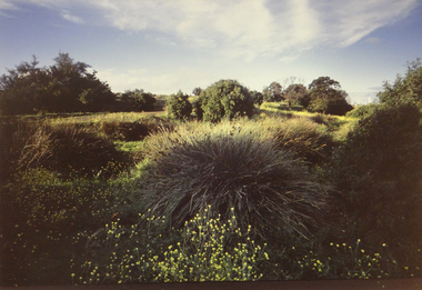
 Brimbank City Council Art Collection
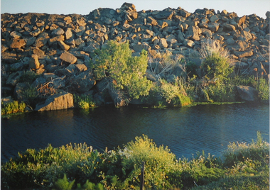
Photograph, Robert Pointon, River Rocks, 1988
... West bank Kororoit Creek looking east. Looking directly across the creek. ...Part of the 1989 Hunt Club Exhibition. photograph kororoit creek robert pointon West bank Kororoit Creek looking east. Looking directly across the creek. ...Local Significance. Part of the 1989 Hunt Club Exhibition.West bank Kororoit Creek looking east. Looking directly across the creek. Foliage in the immediate foreground. Creek in the midground, Stone embankment across the river. - AR0038photograph, kororoit creek, robert, pointon -
 Bendigo Historical Society Inc.
Postcard - Alice McGregor Postcard Collection, 1900 - 1920
... Stapleton, Arcade, Bendigo, Victoria, Australia Sender - M. Preston, West Bank, East London, S.A. Stamp date Sept. 28, 1905 ...Stapleton, Arcade, Bendigo, Victoria, Australia Sender - M. Preston, West Bank, East London, S.A. Stamp date Sept. 28, 1905 Postcard Album of Alice McGregor containing 86 post cards. ...Alice McGREGOR Born: 1908; unknown parents. Possibly adopted by the Salter family? Electoral Roll 1936: Highland Terrace Kangaroo Flat. Alice Mary Salter and William Robert Salter living together; presumed to be sister and brother. William Robert Salter was killed in a MVA in Bendigo in 1937 aged 26. In Victoria in 1938, Alice Mary Salter married James Thomas McGregor (born Victoria 1917, died Victoria 1983, buried Fawkner Cemetery) Lived: 1968; 22 Wade Street Golden Square Alice McGregor Died: 1999 aged 91 at Anne Caudle Centre, Bendigo Buried: Kangaroo Flat Cemetery See additional research. Postcard Album of Alice McGregor contained 86 post cards.Postcard Album of Alice McGregor containing 86 post cards. See 1400 Colour photo of Herte Street, Stellenbosch, South Africa. Tree lined avenue with houses either side. Addressed to Miss A. Stapleton, Arcade, Bendigo, Victoria, Australia Sender - M. Preston, West Bank, East London, S.A. Stamp date Sept. 28, 1905 postcard, collector, alice mcgregor -
 Tarnagulla History Archive
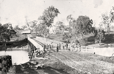
Photograph of the newly completed bridge at Newbridge, Victoria, c.1894, The newly completed bridge at Newbridge, Victoria, c.1894, 1894
... Position of photographer is on the west bank of the Loddon, looking east....Position of photographer is on the west bank of the Loddon, looking east. The newly completed bridge at Newbridge, Victoria, c.1894 Photograph of the newly completed bridge at Newbridge, Victoria, c.1894 ...Murray Comrie Collection. This photograph is a well-preserved original. Monochrome photograph depicting the newly completed wooden bridge at Newbridge, Victoria. Thirteen men are in the image, standing at one end of the bridge. These are most likely men who worked on constructing the bridge. Position of photographer is on the west bank of the Loddon, looking east.newbridge, bridge, loddon river, infrastructure, construction, roads, workers, farms, people -
 Lake Bolac & District Historical Society
Black and white photograph, St. Bernards Roman Catholic Church, Lake Bolac
... Built by Robert Pitkethley on the west bank of the lake and completed in 1874. ...Built by Robert Pitkethley on the west bank of the lake and completed in 1874. ...St Bernard's Roman Catholic Church, Lake Bolac. Built by Robert Pitkethley on the west bank of the lake and completed in 1874. It was consecrated by Bishop Gould of Melbourne.st bernard's roman catholic church, lake bolac, pitkethley, bishop gould -
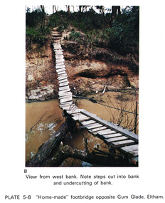 Eltham District Historical Society Inc
Work on paper (Sub-Item) - Photograph, Home-made footbridge across Diamond Creek, opposite Gum Glade, Eltham
... Colour photograph of home-made footbridge across the Diamond Creek opposite Gum Glade, Eltham. View from west bank. Note steps cut into bank and undercutting of bank...Eltham District Historical Society Inc 728 Main Rd Eltham melbourne Colour photograph of home-made footbridge across the Diamond Creek opposite Gum Glade, Eltham. View from west bank. Note steps cut into bank and undercutting of bank eltham diamond creek footbridge gum glade creek bank Image printed on A4 page from 04997 Diamond Creek Basin Study, 1980 Home-made footbridge across Diamond Creek, opposite Gum Glade, Eltham Work on paper Photograph ...Colour photograph of home-made footbridge across the Diamond Creek opposite Gum Glade, Eltham. View from west bank. Note steps cut into bank and undercutting of bankeltham, diamond creek, footbridge, gum glade, creek bank -
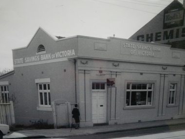 Glen Eira Historical Society
Historical Caulfield to 1972, photo album by Jenny O’Donnell, Hawthorn Rd
... 1 photo of number 144 State Savings Bank Caulfield West branch...Glen Eira Historical Society 965 Glen Huntly Rd Caulfield VIC 3162 melbourne Caulfield North Hawthorn Rd State Savings Bank Banks O’Donnell Jenny 1 photo of number 144 State Savings Bank Caulfield West branch Historical Caulfield to 1972, photo album by Jenny O’Donnell, Hawthorn Rd ...1 photo of number 144 State Savings Bank Caulfield West branchcaulfield north, hawthorn rd, state savings bank, banks, o’donnell, jenny -
 Port of Echuca
Black and white photograph, 04/03/1984
... Photograph taken from the river looking west towards the Echuca bank. Spectators line the higher banks and to the water line in the foreground. ...banks. Photograph possibly taken from the river looking west towards the Echuca bank....banks. Photograph possibly taken from the river looking west towards the Echuca bank. ...Photograph related to no.P000041, P000045 - P000048 of P. S. Adelaide re-floating. Copyright held by Riverine Herald newspaper. Original and negatives held by Riverine Herald.. Photograph taken from the river looking west towards the Echuca bank. Spectators line the higher banks and to the water line in the foreground. The back of the Adelaide and funnel is in clear view with the wheelhouse being partially obscured. The re-floating of the P. S. Adelaide was a Significant community social event evident by the number of spectators in the photograph. The community had invested a great deal of time and money into re-floating the paddlesteamer. The newspaper covered the event in detail with a number of action shots as the boat made its rear entry from the soil ramp to the water.Black and white photograph of the P. S. Adelaide on a ramp being prepared for re-floating. Spectators line the higher banks. Photograph possibly taken from the river looking west towards the Echuca bank.p. s. adelaide, echuca,victoria, re-floating of the p. s. adelaide. riverine herald newspapers, -
 Sunbury Family History and Heritage Society Inc.
Photograph, Rosa McCall, 2011
... The 'Pioneer Inn' was the first hotel to be built in Sunbury. It was on the west bank of the Jackson Creek near Powlett Street. ...The 'Pioneer Inn' was the first hotel to be built in Sunbury. It was on the west bank of the Jackson Creek near Powlett Street. ...The two-arched bluestone bridge spans the Jackson Creek on Macedon Street in Sunbury. It was built in 1860 and continued to carry traffic in and out of Sunbury until the early 1970s. The bend in the road on the approach to the east side was removed and a new bridge was built to carry the traffic. The old bridge became part of a pedestrian walk. The 'Pioneer Inn' was the first hotel to be built in Sunbury. It was on the west bank of the Jackson Creek near Powlett Street. Goonawarra is the building in the background.Until 1860 a punt was used to carry people and traffic across the Jackson Creek in Sunbury.A coloured photograph of a two-arched bluestone bridge spanning a waterway. Low growing trees and vegetation are growing along the river banks. A double-storey building is visible in the distance.bridges, bluestone road bridge, macedon street bridge, pioneer inn, powlett street, jackson street, goonawarra vineyard -
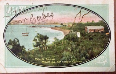 Phillip Island and District Historical Society Inc.
Photograph - Post Card, Newhaven postcard, About 1910
... bank...Harry West...Postcard from Lizzie to Mrs Harry West " Moncrieff Bank", Cowes. 'Wishing you all A happy and Prosperous New Year 1910. ...Phillip Island and District Historical Society Inc. phillip-island-and-the-bass-coast Postcard from Lizzie to Mrs Harry West " Moncrieff Bank", Cowes. 'Wishing you all A happy and Prosperous New Year 1910. ...Postcard from Lizzie to Mrs Harry West " Moncrieff Bank", Cowes. 'Wishing you all A happy and Prosperous New Year 1910. Your loving cousin, Lizzie'Coloured postcard showing coastline, bay, jetty and buildings at Newhaven. Looking towards San RemoPhillip Island Newhaven, San Remo in the distance. Greetings from Cowes written in gold glitternewhaven, jetty, newhaven, photographs, postcards, moncrieff bank, harry west -
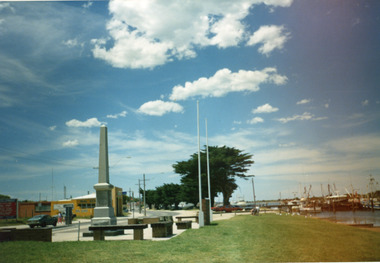 Lakes Entrance Historical Society
Photograph - Cenotaph, Bess Larkins, 1989
... Colour photograph of the Lakes Entrance War Memorial when situated on south side of Esplanade, west of Bank Jetty. Shows monument with inscriptions and tall four-sided pillar on concrete forecourt, two flagpoles and low seating. ...Lakes Entrance Historical Society 4 Marine Parade Lakes Entrance gippsland Also one other photograph, size 15 x 10, different perspective, with lake and sanddunes in background, donated by Vera Bennett World War 1914-1918 Memorials Colour photograph of the Lakes Entrance War Memorial when situated on south side of Esplanade, west of Bank Jetty. Shows monument with inscriptions and tall four-sided pillar on concrete forecourt, two flagpoles and low seating. ...Also one other photograph, size 15 x 10, different perspective, with lake and sanddunes in background, donated by Vera BennettColour photograph of the Lakes Entrance War Memorial when situated on south side of Esplanade, west of Bank Jetty. Shows monument with inscriptions and tall four-sided pillar on concrete forecourt, two flagpoles and low seating. Lakes Entrance Victoriaworld war 1914-1918, memorials -
 Ringwood and District Historical Society
Photograph, Mullum Mullum Creek- 29-10-89
... "Written on back of photograph" Mullum Mullum Creek North bank West of Harrison St Rubbish and weeds - view generally to the East...Ringwood and District Historical Society 125A Warrandyte Road Ringwood North melbourne "Written on back of photograph" Mullum Mullum Creek North bank West of Harrison St Rubbish and weeds - view generally to the East Black and white photograph Mullum Mullum Creek- 29-10-89. ...Black and white photograph"Written on back of photograph" Mullum Mullum Creek North bank West of Harrison St Rubbish and weeds - view generally to the East -
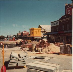 Bendigo Historical Society Inc.
Photograph - EVA WILSON COLLECTION: HARGREAVES MALL CONSTRUCTION 1982
... Photo dated 04/04/82 showing Norris' corner from bank looking west....History House 11 Mackenzie Street Bendigo goldfields PLACE Mall hargreaves mall Bendigo Hargreaves Mall Photo dated 04/04/82 showing Norris' corner from bank looking west. Photograph EVA WILSON COLLECTION: HARGREAVES MALL CONSTRUCTION 1982 ...Photo dated 04/04/82 showing Norris' corner from bank looking west.place, mall, hargreaves mall, bendigo hargreaves mall -
Tatura Irrigation & Wartime Camps Museum
Photograph, Johnson's Newsagency Streetscape Looking West
... Johnson's Newsagent & Stationer, streetscape of Hogan Street looking west. Solicitor's Chambers, CBC Bank. c1935....Tatura Irrigation & Wartime Camps Museum 49 Hogan Street Tatura the-murray tatura buildings historic street furniture signs CBC Johnson's Newsagent & Stationer, streetscape of Hogan Street looking west. Solicitor's Chambers, CBC Bank. c1935. Johnson's Newsagency Streetscape Looking West Photograph Photograph ...Johnson's Newsagent & Stationer, streetscape of Hogan Street looking west. Solicitor's Chambers, CBC Bank. c1935.tatura, buildings, historic, street, furniture, signs, cbc -
Glenelg Shire Council Cultural Collection
Photograph - Contact Print - Scenes of Portland, Victoria, 1970s
... Sheet of 12 contact prints of rephotographed photographs: (a) 5 young women on dam wall (b) sailors (c) Bentinck Street, looking north from Post Office (d) Julia Street looking east from Percy Street (e) Railway line and Duttons (Nuns) Beach towards Whalers Bluff (f) Fawthrop Lagoon (g) sailors (h) Post Office (i) River, bush close to banks both sides (j) Botanic Gardens (k) Town and Port of Portland reproduced from III London News (l) North side, Julia Street looking west, Bank Australasia...Glenelg Shire Council Cultural Collection History House Cliff Street Portland great-ocean-road Portland scene street scene photography Portland Harbour Portland seafront Julia Street Front: (c) Bentinck Street approx. 1900 (d) Julia Street, portland Nicholls (h) Portland Post Office Sheet of 12 contact prints of rephotographed photographs: (a) 5 young women on dam wall (b) sailors (c) Bentinck Street, looking north from Post Office (d) Julia Street looking east from Percy Street (e) Railway line and Duttons (Nuns) Beach towards Whalers Bluff (f) Fawthrop Lagoon (g) sailors (h) Post Office (i) River, bush close to banks both sides (j) Botanic Gardens (k) Town and Port of Portland reproduced from III London News (l) North side, Julia Street looking west, Bank Australasia Photograph Contact Print - Scenes of Portland, Victoria ...Sheet of 12 contact prints of rephotographed photographs: (a) 5 young women on dam wall (b) sailors (c) Bentinck Street, looking north from Post Office (d) Julia Street looking east from Percy Street (e) Railway line and Duttons (Nuns) Beach towards Whalers Bluff (f) Fawthrop Lagoon (g) sailors (h) Post Office (i) River, bush close to banks both sides (j) Botanic Gardens (k) Town and Port of Portland reproduced from III London News (l) North side, Julia Street looking west, Bank AustralasiaFront: (c) Bentinck Street approx. 1900 (d) Julia Street, portland Nicholls (h) Portland Post Officeportland scene, street scene, photography, portland harbour, portland seafront, julia street