Showing 78 items matching "western port phillip island"
-
 Phillip Island and District Historical Society Inc.
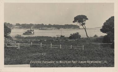
Photograph - Post Card, Early 20th Century
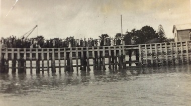
... western port phillip island...Phillip Island and District Historical Society Inc. phillip-island-and-the-bass-coast One of a group of photographs from the Bryant West Collection donated by Mary Karney. western port phillip island ferries san remo bryant west collection mary karney Eastern Entrance to Western Port from Newhaven. 16. ...One of a group of photographs from the Bryant West Collection donated by Mary Karney.Black & White postcard of the Eastern Entrance to Westernport showing a Ferry and other vessels with San Remo on the other side of the bay.Eastern Entrance to Western Port from Newhaven. 16.western port phillip island, ferries, san remo, bryant west collection, mary karney -
 Greensborough Historical Society
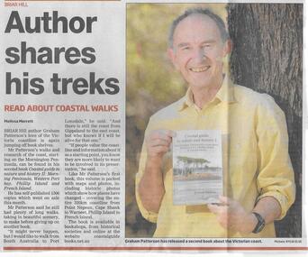
Newspaper clipping, Author shares his treks, 31/12/2014
... Briar Hill author Graham Patterson discusses his latest book "Coastal Guide to nature and history II: Mornington Peninsula, Western Port Bay, Phillip Island and French Island"....Greensborough Historical Society 34A Glenauburn Road Lower Plenty Lower Plenty melbourne Briar Hill author Graham Patterson discusses his latest book "Coastal Guide to nature and history II: Mornington Peninsula, Western Port Bay, Phillip Island and French Island". Local author graham patterson briar hill authors Date in pen. ...Briar Hill author Graham Patterson discusses his latest book "Coastal Guide to nature and history II: Mornington Peninsula, Western Port Bay, Phillip Island and French Island".Local authorNews clipping, black text, colour image.Date in pen.graham patterson, briar hill, authors -
 Flagstaff Hill Maritime Museum and Village
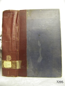
Book, The Logbooks of The Lady Nelson, 1915
... The Lady Nelson visits Norfolk Island and Port Dalrymple. - Chapter 12: Tippahee and his four sons are conveyed to New Zealand in the Lady Nelson. - Chapter 13: The Lady Nelson accompanies HMS Tamar to Melville Island. - Chapter 14: The loss of the Lady Nelson Text included with the ‘Chart of Bass Strait’ … “Part of Bass Strait, including the discoveries made by Acting Lieut. J. Murray, commander of His Majesty’s armed surveying vessel Lady Nelson, between November 1801 and March 1802. By command of His Excellency Governor King.” “This chart, which bears Murray’s autograph, shows his explorations of Western Port, Port Phillip...The Lady Nelson visits Norfolk Island and Port Dalrymple. - Chapter 12: Tippahee and his four sons are conveyed to New Zealand in the Lady Nelson. - Chapter 13: The Lady Nelson accompanies HMS Tamar to Melville Island. - Chapter 14: The loss of the Lady Nelson Text included with the ‘Chart of Bass Strait’ … “Part of Bass Strait, including the discoveries made by Acting Lieut. J. Murray, commander of His Majesty’s armed surveying vessel Lady Nelson, between November 1801 and March 1802. By command of His Excellency Governor King.” “This chart, which bears Murray’s autograph, shows his explorations of Western Port, Port Phillip ...This hardcover book, The logbooks of the 'Lady Nelson' : with the journal of her first commander, Lieutenant James Grant, R.N., by Ida Lee (Mrs Charles Bruce Marriott) was published over 100 years after the Lady Nelson arrived in Australia to navigate and survey this ‘new colony’. Included in the book are sixteen charts and illustrations from the originals in the Admiralty Library, showing the surveyed land and water. The transcribed Contents, below, summarise the trips of the Lady Nelson during this time. Book’s Content PLUS text of the Chart of ‘Part of Bass Strait’ - Chapter 1: The Lady Nelson built with centreboards. Her voyage to Sydney under James Grant. The first ship to pass through Bass Strait. - Chapter 2: Returns to explore the Strait. Her visits to Jervis Bay and to Western Port in 1801 - Chapter 3: Colonel Paterson and Lieutenant Grant survey Hunter River - Chapter 4: Murray appointed commander of the Lady Nelson. His voyage to Norfolk Island. - Chapter 5: Murray’s exploration of Bass Strait. - Chapter 6: Discovery of Port Phillip. - Chapter 7: The Lady Nelson in company with HMS Investigator examines the North-Eastern shores of Australia. - Chapter 8: The French ships in Bass Strait. The founding of Hobart. - Chapter 9: Symons succeeds Curtoys as commander of the Lady Nelson. His voyages to Tasmania, Port Phillip and New Zealand. - Chapter 10: The Lady Nelson in Tasmania. The founding of Port Dalrymple. - Chapter 11: The Estramina is brought to Sydney. The Lady Nelson visits Norfolk Island and Port Dalrymple. - Chapter 12: Tippahee and his four sons are conveyed to New Zealand in the Lady Nelson. - Chapter 13: The Lady Nelson accompanies HMS Tamar to Melville Island. - Chapter 14: The loss of the Lady Nelson Text included with the ‘Chart of Bass Strait’ … “Part of Bass Strait, including the discoveries made by Acting Lieut. J. Murray, commander of His Majesty’s armed surveying vessel Lady Nelson, between November 1801 and March 1802. By command of His Excellency Governor King.” “This chart, which bears Murray’s autograph, shows his explorations of Western Port, Port Phillip and King Island. It should be noted that Flinders Island is named Grand Capuchin. This is one of the charts referred to as "unfortunately missing” in the Historical Records of N.S. Wales, vol. iv. P. 764” The story of the Lady Nelson In 1798 the British Admiralty ordered a cutter of 60 tons to be built along the design of the armed cutter Trial that was developed by Captain John Schanck, with three sliding keels or centreboards that could be individually raised and lowered, for use on the River Thames. The new cutter was to be named Lady Nelson. Philip Gidley King, prior to taking up his appointment as third Governor of the colony of New South Wales, was in England at the time of the Lady Nelson’s fit-out and was aware of the need for such a ship for survey work in the colony in New South Wales. He convinced Captain Schanck, the Commissioner of Transport in England, to construct and rig the Lady Nelson as a brig rather than a cutter, keeping the feature of the three sliding keels, which would be very useful for mapping in shallow waters. The new Lady Nelson was launched at Deptford, England on the River Thames in November 1798, with the official commission to discover and survey the unknown parts of the coast of New Holland (Australia) and establish British sovereignty over the continent. The Lady Nelson sailed from Portsmouth, England on March 1800 under the command of Lieutenant James Grant. She carried an armament of two original and four extra brass carronade carriage guns and set sail as part of a convoy heading to Port Jackson, in New South Wales, New Holland. After a while she continued to sail on her own. Her journey was troubled with problems at times; damaged and broken keels, troublesome crew and leaking topsides between the waterline and the deck due to poor seals. She arrived at the Cape of Good Hope in July and waited for the winter to pass to avoid the strong winds of the ‘Roaring Forties’. While at the Cape, Grant received a despatch to travel to Port Jackson via the newly discovered Bass Strait, rather than the usual route via the tip of Van Diemen’s Land (Tasmania). This also gave him the opportunity to survey the strait on the way. He departed the Cape in October and in December he made his first sighting of New Holland near Mount Gambier in what is now South Australia. A report by Ecclestone in 2012, ‘The Early Charting of Victoria’s Coastline’, mentions that Grant charted and named Capes Banks and Northumberland, and sighted inland hills that he named Mt Gambier and Mt Schanck, the latter after the designer of his ship. Grant then reached the south-western shores of what is now Victoria on 3-4 December 1800, and from Cape Bridgewater he examined the coast eastward to Cape Patton. Although he had not continuously sighted the coast in the vicinity of Port Fairy and Warrnambool, the western part of Victoria became known as Grant’s Land. The Lady Nelson continued eastward and passed through Bass Strait, becoming the first vessel to reach the east coast of New Holland from the west, and arrived at her destination of Port Jackson later in December 1800. Grant, in the Lady Nelson, then left Port Jackson and began survey work. He discovered Port Phillip on Victoria’s coast and explored King Island, he helped establish the first European settlement in Tasmania on the Derwent River, and Port Dalrymple, Newcastle and Port Macquarie. He made several trips from Norfolk Island to Hobart Town. Governor Macquarie sailed on with him to Van Diemen’s Land for a tour of inspection in 1811. Grant helped establish the first settlement on Melville Island in Northern Australia. The Lady Nelson was used to transport cargo, civilians and convicts and to source pigs from Timor. In February 1825 the Lady Nelson sailed again for Timor and never returned. One report said that “Every soul on board, we regret to state, was cruelly massacred, and the hull of the vessel was seen some time after with the name painted on her stern.” The hull was sighted on the island of Babar, which is almost 200 kilometres east of Timor. This particular copy of the book ... This item is from the ‘Pattison Collection’, a collection of books and records that was originally owned by the Warrnambool Mechanics’ Institute, which was founded in Warrnambool in 1853. By 1886 the Warrnambool Mechanics’ Institute (WMI) had grown to have a Library, Museum and Fine Arts Gallery, with a collection of “… choice productions of art, and valuable specimens in almost every branch and many wonderful national curiosities are now to be seen there, including historic relics of the town and district.” It later included a School of Design. Although it was very well patronised, the lack of financial support led the WMI in 1911 to ask the City Council to take it over. In 1935 Ralph Pattison was appointed as City Librarian to establish and organise the Warrnambool Library as it was then called. When the WMI building was pulled down in 1963 a new civic building was erected on the site and the new Warrnambool Library, on behalf of the City Council, took over all the holdings of the WMI. At this time some of the items were separated and identified as the ‘Pattison Collection’, named after Ralph Pattison. Eventually the components of the WMI were distributed from the Warrnambool Library to various places, including the Art Gallery, Historical Society and Flagstaff Hill. Later some were even distributed to other regional branches of Corangamite Regional Library and passed to and fro. It is difficult now to trace just where all of the items have ended up. The books at Flagstaff Hill Maritime Village generally display stamps and markings from Pattison as well as a variety of other institutions including the Mechanics’ Institute itself. RALPH ERIC PATTISON Ralph Eric Pattison was born in Rockhampton, Queensland, in 1891. He married Maude Swan from Warrnambool in 1920 and they set up home in Warrnambool. In 1935 Pattison accepted a position as City Librarian for the Warrnambool City Council. His huge challenge was to make a functional library within two rooms of the Mechanics’ Institute. He tirelessly cleaned, cleared and sorted a disarrayed collection of old books, jars of preserved specimens and other items reserved for exhibition in the city’s museum. He developed and updated the library with a wide variety of books for all tastes, including reference books for students; a difficult task to fulfil during the years following the Depression. He converted all of the lower area of the building into a library, reference room and reading room for members and the public. The books were sorted and stored using a cataloguing and card index system that he had developed himself. He also prepared the upper floor of the building and established the Art Gallery and later the Museum, a place to exhibit the many old relics that had been stored for years for this purpose. One of the treasures he found was a beautiful ancient clock, which he repaired, restored and enjoyed using in his office during the years of his service there. Ralph Pattison was described as “a meticulous gentleman whose punctuality, floorless courtesy and distinctive neat dress were hallmarks of his character, and ‘his’ clock controlled his daily routine, and his opening and closing of the library’s large heavy doors to the minute.” Pattison took leave during 1942 to 1945 to serve in the Royal Australian Navy, Volunteer Reserve as Lieutenant. A few years later he converted one of the Museum’s rooms into a Children’s Library, stocking it with suitable books for the younger generation. This was an instant success. In the 1950’s he had the honour of being appointed to the Victorian Library Board and received more inspiration from the monthly conferences in Melbourne. He was sadly retired in 1959 after over 23 years of service, due to the fact that he had gone over the working age of council officers. However he continued to take a very keen interest in the continual development of the Library until his death in 1969 This book about the logbooks of the Lady Nelson is locally significant for its association with the brig Lady Nelson, in which Lt. James Grant made the first documented European discovery of the area later known as Warrnambool in December 1800. This book is also nationally significant for its association with Grant in the Lady Nelson being the first to sail from west to east through Bass Strait, opening up a shorter, faster route to the colony of Port Jackson rather than going all the way south around Van Diemen’s Land. The book is nationally significant for its contents of the logbooks of the journeys of the Lady Nelson under various commanders and the copies of the charts created from the surveyed information and the new land of Australia was discovered. This book is also significant for its association with the full-size non-sailing replica of the Lady Nelson from Mount Gambier’s visitor centre, which was restored by Flagstaff Hill’s Master Boat Builder in Warrnambool in 2012, and with a ship mode of the Lady Nelson in our Collection The Pattison Collection, along with other items at Flagstaff Hill Maritime Village, was originally part of the Warrnambool Mechanics' Institute’s collection. The Warrnambool Mechanics’ Institute Collection is primarily significant in its totality, rather than for the individual objects it contains. Its contents are highly representative of the development of Mechanics' Institute libraries across Australia, particularly Victoria. A diversity of publications and themes has been amassed, and these provide clues to our understanding of the nature of and changes in the reading habits of Victorians from the 1850s to the middle of the 20th century. The collection also highlights the Warrnambool community’s commitment to the Mechanics’ Institute, reading, literacy and learning in the regions, and proves that access to knowledge was not impeded by distance. These items help to provide a more complete picture of our community’s ideals and aspirations. The Warrnambool Mechanics Institute book collection has historical and social significance for its strong association with the Mechanics Institute movement and the important role it played in the intellectual, cultural and social development of people throughout the latter part of the nineteenth century and the early twentieth century. The collection of books is a rare example of an early lending library and its significance is enhanced by the survival of an original collection of many volumes. The Warrnambool Mechanics' Institute’s publication collection is of both local and state significance. The Logbooks of The Lady Nelson Author: Ida Lee ( Mrs Charles Bruce Marriott) Publisher: Grafton & Co Date: 1915Label on spine with typed text RA 910.994 LEE Inside front cover has a sticker that reads Warrnambool Mechanics Institute and Free Library shipwrecked-coast, flagstaff-hill, warrnambool, flagstaff-hill-maritime-museum, maritime-museum, shipwreck-coast, flagstaff-hill-maritime-village, shipwrecked-artefact, book, warrnambool library, warrnambool mechanics’ institute, warrnambool city librarian, mechanics’ institute library, victorian library board, warrnambool books and records, warrnambool children’s library, great ocean road, the logbooks of the lady nelson, ida lee, mrs charles bruce marriott, captain john schanck, sliding keels or centreboards, lady nelson, british brig hms lady nelson, lieutennant james grant, bass strait discovery, surveying king island and port phillip bay, philip gidley king, survey map -
 Bendigo Military Museum
Map - RASvy " Map Makers Exhibition 2025 "- Map display, RAN Hydrographic Office, 1972 - 1992
... Current as at 30 Jun 92. .2 Extract of Navigational Plotting Chart " NP22-2 Tasmania " .3 Extract of Navigational Plotting Chart " NP 27 RAAF PLOTTING CHART AUSTRALIA - SOUTHEAST " .4 Extract of Navigational Plotting Chart " RAAF LONG RANGE PLOTTING CHART NP43-4 AUSTRALIA WESTERN " .5 Extract of Navigational Plotting Chart " RAAF LONG RANGE PLOTTING CHART NP43-7 SOLOMON ISLANDS " .6 Extract of Navigational Series " RAAF AIR STAFF PLANNING CHART NS 137-2 DARWIN NORTH WEST " .7 Extract of Navigational Series " RAAF AIR STAFF PLANNING CHART NS 137-1 DARWIN NORTH EAST " .8 Extract of Navigational Series " RAAF AIR STAFF PLANNING CHART NS 137-4 DARWIN SOUTH WEST " .9 Extract of Navigational Series " RAAF AIR STAFF PLANNING CHART NS 137-3 DARWIN SOUTH EAST " .10 Extract of Tactical Pilotage Chart " TPC R-13B " .11 Extract of Hydrographic Chart " PORT PHILLIP SOUTH and WEST CHANNELS " .12 Extract of Hydrographic Chart " GEELONG HARBOUR and APPROACHES " .13 Extract of En Route Chart " AUSTRALIA ERC HIGH " " H1 and H2 " ...Current as at 30 Jun 92. .2 Extract of Navigational Plotting Chart " NP22-2 Tasmania " .3 Extract of Navigational Plotting Chart " NP 27 RAAF PLOTTING CHART AUSTRALIA - SOUTHEAST " .4 Extract of Navigational Plotting Chart " RAAF LONG RANGE PLOTTING CHART NP43-4 AUSTRALIA WESTERN " .5 Extract of Navigational Plotting Chart " RAAF LONG RANGE PLOTTING CHART NP43-7 SOLOMON ISLANDS " .6 Extract of Navigational Series " RAAF AIR STAFF PLANNING CHART NS 137-2 DARWIN NORTH WEST " .7 Extract of Navigational Series " RAAF AIR STAFF PLANNING CHART NS 137-1 DARWIN NORTH EAST " .8 Extract of Navigational Series " RAAF AIR STAFF PLANNING CHART NS 137-4 DARWIN SOUTH WEST " .9 Extract of Navigational Series " RAAF AIR STAFF PLANNING CHART NS 137-3 DARWIN SOUTH EAST " .10 Extract of Tactical Pilotage Chart " TPC R-13B " .11 Extract of Hydrographic Chart " PORT PHILLIP SOUTH and WEST CHANNELS " .12 Extract of Hydrographic Chart " GEELONG HARBOUR and APPROACHES " .13 Extract of En Route Chart " AUSTRALIA ERC HIGH " " H1 and H2 " RASvy " Map Makers Exhibition 2025 "- Map display Map RASvy " Map Makers Exhibition 2025 "- Map display RAN Hydrographic Office Aeronautical Information Service. ...All of these Charts / Maps were used for the RSL Museum display " The Mapmakers " ( of RASvy. ) 10 Jun - 10 Aug 2025. .1 Catalogue of Tactical Pilotage Charts, 1:500 000 Scale. Digital Data Base available as at 30Jun 92. This catalogue page shows the extent of the Australian area of responsibility for aeronautical charting. .2 RAAF PLOTTING CHART. NP 22-2 (Navigational Plotting) Tasmania. MERCATOR PROJECTION. This series of charts were used for the training of RAAF Navigators. These charts were produced and printed at the Army Survey Regiment, Bendigo. .3 RAAF PLOTTING CHART AUSTRALIA - SOUTHEAST. NP 27 is Based on LAMBERT CONFORMAL CONIC PROJECTION. This series of charts was used by RAAF Navigators for the planning of RAAF flights. These charts were produced and printed at the Army Survey Regiment, Bendigo. .4 RAAF LONG RANGE PLOTTING CHART. NP 43-4 AUSTRALIA WESTERN. MERCATOR PROJECTION. This series of maps were used for the planning of RAAF flights. Of Particular note these charts were used to plot "Rhumb Lines or loxodromes" where a course crosses all Meridians (Lines of latitude and longitude) at the same angle. On Mercator projection charts Rhumb lines are conveniently shown as straight lines and are also lines of constant compass bearing. Rhumb lines are usually longer than the shortest distance between two points. The shortest distance between two points on the earth's surface is called a "Great Circle Route" which is a route on a circular path on the surface of the earth where the centre of that circle is also the centre of the earth. Great Circle Routes on a Mercator Projection are however curves and harder to plot. These charts were produced and printed at the Army Survey Regiment, Bendigo. .5 RAAF LONG RANGE PLOTTING CHART. NP 43-7 SOLOMON ISLANDS. MERCATOR PROJECTION. Used for the planning of RAAF flights. .6 RAAF AIR STAFF PLANNING CHART NS 137-1 DARWIN NORTH WEST. AZIMUTHAL EQUIDISTANT PROJECTION. This series of charts were used for planning by the staff. The whole chart was produced by joining the four quadrant maps together. The charts are based on a single point of tangency (in this case Darwin) and shows radius (distance) in nautical miles to and from that point. A series of charts were produced centred on each of the major airfields in Northern Australia. These charts were produced and printed at the Army Survey Regiment, Bendigo. .7 RAAF AIR STAFF PLANNING CHART NS 137-2 DARWIN NORTH EAST. AZIMUTHAL EQUIDISTANT PROJECTION. Used for the planning by the staff. The charts are based on a point of tangency and show radius in nautical miles. .8 RAAF AIR STAFF PLANNING CHART NS 137-4 DARWIN SOUTH WEST. AZIMUTHAL EQUIDISTANT PROJECTION. Used for the planning by the staff. The charts are based on a point of tangency and show radius in nautical miles. .9 RAAF AIR STAFF PLANNING CHART NS 137-3 DARWIN SOUTH EAST. AZIMUTHAL EQUIDISTANT PROJECTION. Used for the planning by the staff. The charts are based on a point of tangency and show radius in nautical miles. .10 TACTICAL PILOTAGE CHART. TPC R-13B. LAMBERT CONFORMAL PROJECTION. Used by pilots for flight planning and could be used in flight if necessary for visual navigation using major ground features shown on the chart. These charts also contained aeronautical information such as airfields, radio navigation beacons and obstructions. Contours and height information was shown in feet to be compatible with aircraft altimeters. Each graticule square also contained a Maximum Safe Elevation Figure (MEF) also in feet. Coverage of this series over Australia's area of interest were produced and printed at the Army Survey Regiment, Bendigo. .11 HYDROGRAPHIC CHART. AUS 158. PORT PHILLIP SOUTH and WEST CHANNELS. PROJECTION TRANSVERSE MERCATOR. Used by all people needing to navigate a vessel. Hydrographic charts were printed at the Army Survey Regiment, Bendigo. .12 HYDROGRAPHIC CHART. AUS 157. GEELONG HARBOUR and APPROACHES. PROJECTION TRANSVERSE MERCATOR. Used by all people needing to navigate a vessel. .13 EN ROUTE CHART. AUSTRALIA ERC HIGH. H1 and H2. LAMBERT CONFORMAL CONIC PROJECTION. This series of charts were regularly produced by the RAAF Aeronautical Information Service (AIS) and contained current aeronautical information for pilots. These charts were printed at the Army Survey Regiment, Bendigo..1 Tactical Pilotage Chart Series Catalogue. Current as at 30 Jun 92. .2 Extract of Navigational Plotting Chart " NP22-2 Tasmania " .3 Extract of Navigational Plotting Chart " NP 27 RAAF PLOTTING CHART AUSTRALIA - SOUTHEAST " .4 Extract of Navigational Plotting Chart " RAAF LONG RANGE PLOTTING CHART NP43-4 AUSTRALIA WESTERN " .5 Extract of Navigational Plotting Chart " RAAF LONG RANGE PLOTTING CHART NP43-7 SOLOMON ISLANDS " .6 Extract of Navigational Series " RAAF AIR STAFF PLANNING CHART NS 137-2 DARWIN NORTH WEST " .7 Extract of Navigational Series " RAAF AIR STAFF PLANNING CHART NS 137-1 DARWIN NORTH EAST " .8 Extract of Navigational Series " RAAF AIR STAFF PLANNING CHART NS 137-4 DARWIN SOUTH WEST " .9 Extract of Navigational Series " RAAF AIR STAFF PLANNING CHART NS 137-3 DARWIN SOUTH EAST " .10 Extract of Tactical Pilotage Chart " TPC R-13B " .11 Extract of Hydrographic Chart " PORT PHILLIP SOUTH and WEST CHANNELS " .12 Extract of Hydrographic Chart " GEELONG HARBOUR and APPROACHES " .13 Extract of En Route Chart " AUSTRALIA ERC HIGH " " H1 and H2 " royal australian survey corps, rasvy, fortuna, detachment - army survey regiment, army svy regt, asr -
 Phillip Island and District Historical Society Inc.
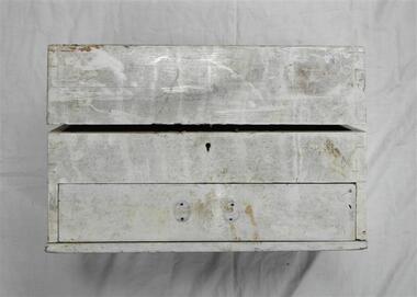
Medicine chest, 1887
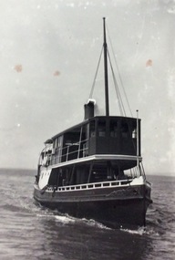
... Phillip Island and District Historical Society Inc. phillip-island-and-the-bass-coast From the passenger ferry Alvina which worked on Western Port from 1925 to 1938. ...From the passenger ferry Alvina which worked on Western Port from 1925 to 1938. Built as a yacht in England.Wooden medicine chest with small compartments for medicines and drawer beneath. -
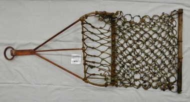 Phillip Island and District Historical Society Inc.
Oyster Dredge, 1920's
... Phillip Island and District Historical Society Inc. phillip-island-and-the-bass-coast Used in the oyster dredging industry in the early 20th century by the Richardson family of Rhyll on Westernport. oysters western port dredge oyster dredge dinny justice john jansson charlie richardson Wrought iron frame with tarred marline net and 8g fencing wire ring bag. ...Used in the oyster dredging industry in the early 20th century by the Richardson family of Rhyll on Westernport.Wrought iron frame with tarred marline net and 8g fencing wire ring bag.oysters western port dredge, oyster dredge, dinny justice, john jansson, charlie richardson -
 Phillip Island and District Historical Society Inc.
Grinding Mill, 1800 - 1900 (Estimated)
... Phillip Island. A Grinding Mill for the soft red stone used for decorating the body. It was picked up by Mr H. R. Balfour of Hopetown Road, Toorak, in November 1904 and was kindly given to a member of the Phillip Island & Western Port Historical Society. ...Phillip Island and District Historical Society Inc. phillip-island-and-the-bass-coast "A veritable powder puff of the stone ages and one of the most interesting relics of the Aborigines yet found on Phillip Island. A Grinding Mill for the soft red stone used for decorating the body. It was picked up by Mr H. R. Balfour of Hopetown Road, Toorak, in November 1904 and was kindly given to a member of the Phillip Island & Western Port ..."A veritable powder puff of the stone ages and one of the most interesting relics of the Aborigines yet found on Phillip Island. A Grinding Mill for the soft red stone used for decorating the body. It was picked up by Mr H. R. Balfour of Hopetown Road, Toorak, in November 1904 and was kindly given to a member of the Phillip Island & Western Port Historical Society. Although used for the last ime more than 100 years earlier, some of the ground stone adheres to the surface that has been smoothed by much use." Taken from the label associated with this object. This label is a typed version of the original label.Grinding mill, oval shaped, stone is very regular and smooth with a textured surface. One side is worn flat and smooth and has traces of red ochre on it.local aboriginal history, aboriginal artifact, stone tool, aboriginal grinding mill -
Phillip Island and District Historical Society Inc.
Framed Certificate, 27-02-1921
... Presented to Mr Arnie Brown as a token of grateful thankfulness and appreciation of his prompt action in rescuing us from drowning when the dinghy was upset at Cowes, Phillip Island, Western Port Bay, 27th February, 1921. ...Phillip Island and District Historical Society Inc. phillip-island-and-the-bass-coast As written on Certificate local history documents certificates certificate bravery award Presented to Mr Arnie Brown as a token of grateful thankfulness and appreciation of his prompt action in rescuing us from drowning when the dinghy was upset at Cowes, Phillip Island, Western Port Bay, 27th February, 1921. ...As written on CertificateFramed Bravery Award to Arnie Brown from grateful recipients he'd saved from drowning. Illuminated hand painted in water colours and gold. Signed by Robert Anderson and James Douglas.Presented to Mr Arnie Brown as a token of grateful thankfulness and appreciation of his prompt action in rescuing us from drowning when the dinghy was upset at Cowes, Phillip Island, Western Port Bay, 27th February, 1921. Mr. James Douglas. Mr. Robert Anderson. [signed] Robert Anderson J. Douglaslocal history, documents, certificates, certificate, bravery award -
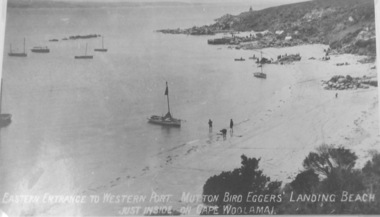 Phillip Island and District Historical Society Inc.
Photograph, Eastern Entrance to Western Port. Mutton Bird Eggers' Landing Beach
... Phillip Island and District Historical Society Inc. phillip-island-and-the-bass-coast Part of a collection of Rose & Valentine Postcards. Copied by John Jansson 1984 local history photography photographs postcards black & white postcard copy cape woolamai eastern entrance mutton bird egg collectors phillip island Eastern entrance to Western Port. ...Part of a collection of Rose & Valentine Postcards. Copied by John Jansson 1984Black & White Postcard. View of Cape Woolamai showing Eastern entrance and mutton birders & egg collectors just inside on Cape Woolamai.Eastern entrance to Western Port. Mutton bird eggers landing beach, just inside Cape Woolamailocal history, photography, photographs, postcards, black & white postcard copy, cape woolamai, eastern entrance, mutton bird egg collectors, phillip island -
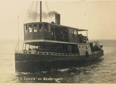
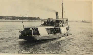 Phillip Island and District Historical Society Inc.
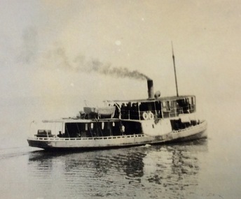
Photograph, Genista off from San Remo, ?
... phillip island shipping...ferries...black & white photograph...phillip island...western port...Phillip Island and District Historical Society Inc. phillip-island-and-the-bass-coast S.S. Genista - built 1886, Sydney. Western Port ...S.S. Genista - built 1886, Sydney. Western Port Ferry 1889 to early 1930's.S.S.Genista off from San Remo. View of stern - pier in background.local history, photographs, transport, shipping, maritime technology, boats, phillip island shipping, ferries, black & white photograph, phillip island, western port -
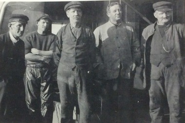 Phillip Island and District Historical Society Inc.
Photograph, Genista's crew 1919, 1919
... phillip island shipping...ferries...black & white photograph...phillip island...western port...Phillip Island and District Historical Society Inc. phillip-island-and-the-bass-coast Group photo of the crew of S.S.Genista 1919 - shown in Fishing gear. local history photographs shipping maritime technology phillip island shipping ferries black & white photograph phillip island western port ferry - genista captain kerr h. kirkland g. kendall mcneil j. jansson Crew of S.S.Genista, 1919. ...Group photo of the crew of S.S.Genista 1919 - shown in Fishing gear.Crew of S.S.Genista, 1919. Left to Right: Capt. Kerr, H.Kirkland, G.Kendall, McNeil, J.Jansson.local history, photographs, shipping, maritime technology, phillip island shipping, ferries, black & white photograph, phillip island, western port, ferry - genista, captain kerr, h. kirkland, g. kendall, mcneil, j. jansson -
 Phillip Island and District Historical Society Inc.
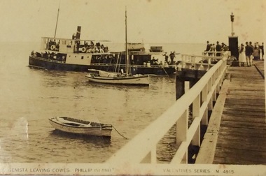
Photograph, Genista leaving Cowes jetty
... phillip island shipping...ferries...black & white photograph...phillip island...western port...Phillip Island and District Historical Society Inc. phillip-island-and-the-bass-coast Part of a collection of the "Rose & Valentine Series" Post Cards. M4915 local history photographs transport shipping maritime technology boats postcards phillip island shipping ferries black & white photograph phillip island western port ferry - genista Valentine series M4915 S.S. ...Part of a collection of the "Rose & Valentine Series" Post Cards. M4915S.S. Genista leaving Cowes Jetty, Phillip Island. G. Walton's fishing boat in foreground. Small rowing boat near foreground.- Valentine series Post Card M4915Valentine series M4915local history, photographs, transport, shipping, maritime technology, boats, postcards, phillip island shipping, ferries, black & white photograph, phillip island, western port, ferry - genista -
 Phillip Island and District Historical Society Inc.
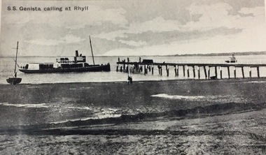
Photograph, Genista calling at Rhyll c1900, ?
... phillip island shipping...ferries...black & white photograph...phillip island...western port...Phillip Island and District Historical Society Inc. phillip-island-and-the-bass-coast S.S. Genista - built in 1886, Sydney. Western Port ...S.S. Genista - built in 1886, Sydney. Western Port Ferry from 1889 to early 1930'sS.S. Genista calling at Rhyll - c.1900 Low tide, sand and mud in foreground.S.S. Genista calling at Rhylllocal history, photographs, transport, shipping, maritime technology, boats, phillip island shipping, ferries, black & white photograph, phillip island, western port, ferry - genista -
 Phillip Island and District Historical Society Inc.
Photograph, Genista carrying wagon and jinker 1917 Also history of the Genista, 1917
... Phillip Island and District Historical Society Inc. phillip-island-and-the-bass-coast "Genista" - built 1886 Sydney. Western Port ..."Genista" - built 1886 Sydney. Western Port Ferry 1889 to early 1930's. Copied by Jack Jenner??"Genista" carrying a wagon and a jinker on top of cabin 1917 Also 4 handwritten sheets describing the history of the Genista and fares.local history, photography, photographs, transport, shipping, black & white photograph, ferries, phillip island, westernport bay, genista - history -
 Phillip Island and District Historical Society Inc.
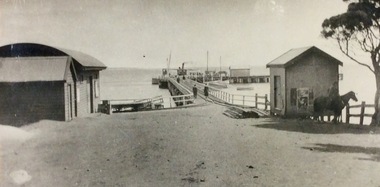
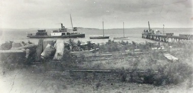
Photograph, Genista at Cowes jetty 1917, 1917
... Phillip Island and District Historical Society Inc. phillip-island-and-the-bass-coast "Genista" - built 1886 Sydney. Western Port ..."Genista" - built 1886 Sydney. Western Port Ferry 1889 to early 1930's. Copied by Jack Jenner??Cowes Jetty, 1917 with ferry "Genista" at end, goods shed and other sheds in foreground. Copy.local history, photography, photographs, transport, shipping, ferries, black & white photograph, phillip island, westernport bay -
 Phillip Island and District Historical Society Inc.
Photograph, Genista leaving Cowes jetty Christmas Day 1917, 1917
... Phillip Island and District Historical Society Inc. phillip-island-and-the-bass-coast "Genista" - built 1886, Sydney. Western Port ..."Genista" - built 1886, Sydney. Western Port Ferry 1889 to early 1930's. Copied by Jack Jenner??The pier, Cowes, 7pm Christmas Day 1917. "Genista" about to leave for San Remo, completing special holiday trip. Copy.local history, photography, photographs, transport, shipping, ferries, black & white photograph, phillip island, westernport bay -
 Phillip Island and District Historical Society Inc.
Photograph, Genista leaving Cowes 1917, 1917?
... Phillip Island and District Historical Society Inc. phillip-island-and-the-bass-coast "Genista" - built 1886, Sydney. Western Port ..."Genista" - built 1886, Sydney. Western Port Ferry 1889 to early 1930's. Copied by Jack Jenner??"Genista" leaving Cowes 1917?local history, photography, photographs, transport, shipping, ferries, black & white photograph, phillip island, westernport bay, ferry - genista -
 Phillip Island and District Historical Society Inc.
Photograph, Genista arriving at Rhyll c1915, 1915
... Phillip Island and District Historical Society Inc. phillip-island-and-the-bass-coast "Genista" - built 1886, Sydney. Western Port ..."Genista" - built 1886, Sydney. Western Port Ferry 1889 to early 1930's"Genista" ariving at Rhyll c.1915local history, photography, photographs, transport, shipping, ferries, black & white photograph, phillip island, westernport bay -
 Phillip Island and District Historical Society Inc.
Photograph, Genista approaching Rhyll c 1915, 1915?
... ...phillip island...western port...Phillip Island and District Historical Society Inc. phillip-island-and-the-bass-coast "Genista" - built 1886, Sydney. Western Port ..."Genista" - built 1886, Sydney. Western Port Ferry 1889 to early 1930's. "Veronica" - built by J. Norling, 1913 at Bass Landing."Genista" approaching Rhyll jetty c.1915. Smaller black boat is John Norling's crayfishing boat - Veronica".local history, photography, photographs, transport, shipping, maritime technology, fisheries, ferries, fishing boats, black & white photograph, phillip island, western port -
 Phillip Island and District Historical Society Inc.
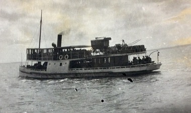
Photograph, Genista on Western Port
... ...phillip island...western port...Phillip Island and District Historical Society Inc. phillip-island-and-the-bass-coast S.S.Genista - built 1886, Sydney. Western Port ...S.S.Genista - built 1886, Sydney. Western Port Ferry 1889 to early 1930's.S.S. Genista sailing on Western Port Bay.local history, photographs, transport, shipping, maritime technology, fisheries, ferries, black & white photograph, phillip island, western port -
 Phillip Island and District Historical Society Inc.
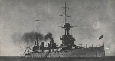
Photograph, Thompson Avenue, Cowes Phillip Island, 1920
... Phillip Island and District Historical Society Inc. phillip-island-and-the-bass-coast This is from Jessie Smith's collection presented by Stan McFee. The vessel is HMS Australia. Avenue shows young Cypress trees planted in 1912 approx. local history photographs mains street - streetscape - cowes phillip island black & white photograph jessie smith main street cowes 1920 Stan McFee HMS Australia 1920 Cowes Black & White Photograph of Thompson Avenue, looking north across Western Port Bay. ...This is from Jessie Smith's collection presented by Stan McFee. The vessel is HMS Australia. Avenue shows young Cypress trees planted in 1912 approx.Black & White Photograph of Thompson Avenue, looking north across Western Port Bay. Silhouetted ship in middle. Young Cypress in middle with lamp-post and pole at extreme right.HMS Australia 1920 Coweslocal history, photographs, mains street - streetscape - cowes, phillip island, black & white photograph, jessie smith, main street cowes 1920, stan mcfee -
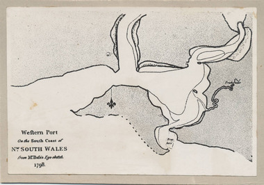 Phillip Island and District Historical Society Inc.
Photograph, Bryant West, 1798
... Phillip Island and District Historical Society Inc. phillip-island-and-the-bass-coast One of a collection of over 400 photographs in an album commenced in 1960 and presented to the Phillip Island & Westernport Historical Society by the Shire of Phillip Island local history photography photographs exploration maritime documents maps george bass phillip island bryant west john jenner As written on front of map - "Western Port on the South Coast of Nw. ...One of a collection of over 400 photographs in an album commenced in 1960 and presented to the Phillip Island & Westernport Historical Society by the Shire of Phillip IslandPhotograph of the First Map of Phillip Island ever drawn. An eye sketch by Bass.As written on front of map - "Western Port on the South Coast of Nw. South Wales from GE Bass's Eye-sketch 1798"local history, photography, photographs, exploration, maritime, documents, maps, george bass, phillip island, bryant west, john jenner -
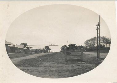
 Phillip Island and District Historical Society Inc.
Photograph, 3/10/1920
... Phillip Island and District Historical Society Inc. phillip-island-and-the-bass-coast One of a collection of over 400 photographs in an album commenced in 1960 and presented to the Historical Society by the Shire of Phillip Island local history photography photographs maritime technology boats shipping - western port - hmas australia black & white photograph hmas australia John Jenner Bryant West Close Photograph of HMAS Australia in Western Port taken from off the starboard bow. ...One of a collection of over 400 photographs in an album commenced in 1960 and presented to the Historical Society by the Shire of Phillip IslandClose Photograph of HMAS Australia in Western Port taken from off the starboard bow.local history, photography, photographs, maritime technology, boats, shipping, - western port - hmas australia, black & white photograph, hmas australia, john jenner, bryant west -
 Phillip Island and District Historical Society Inc.
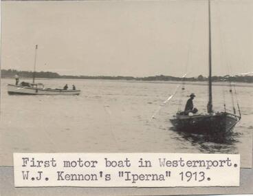
Photograph, 1913
... Phillip Island and District Historical Society Inc. phillip-island-and-the-bass-coast One of a collection of over 400 photographs in an album commenced in 1960 and presented to the Phillip Island & Westernport Historical Society by the Shire of Phillip Island local history photography photographs maritime technology boats motor boat "iperna" black & white photograph motor boats fishing boats w. j. kennon john jenner bryant west Photograph of the first Motor Boat in Western Port. ...One of a collection of over 400 photographs in an album commenced in 1960 and presented to the Phillip Island & Westernport Historical Society by the Shire of Phillip IslandPhotograph of the first Motor Boat in Western Port. W. J. Kennon's "Iperna" 1913local history, photography, photographs, maritime technology, boats, motor boat "iperna", black & white photograph, motor boats, fishing boats, w. j. kennon, john jenner, bryant west -
 Phillip Island and District Historical Society Inc.
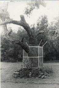
Photograph
... One of a collection of over 400 photographs in an Album commenced in 1960 and presented to the Phillip Island and Western port Historical Society by The Shire Of Phillip Island....Phillip Island and District Historical Society Inc. phillip-island-and-the-bass-coast One of a collection of over 400 photographs in an Album commenced in 1960 and presented to the Phillip Island and Western port Historical Society by The Shire Of Phillip Island. local history photography photographs "edwards" tree black & white photograph famous trees edward the koala broadwater guest house John Jenner Bryant West Photograph of the Koala Edward's Tree fenced in as a memorial near "Broadwater". ...One of a collection of over 400 photographs in an Album commenced in 1960 and presented to the Phillip Island and Western port Historical Society by The Shire Of Phillip Island.Photograph of the Koala Edward's Tree fenced in as a memorial near "Broadwater". Edward is on display in the Phillip Island & District Historical Society's museum in Cowes.local history, photography, photographs, "edwards" tree, black & white photograph, famous trees, edward the koala, broadwater guest house, john jenner, bryant west -
 Phillip Island and District Historical Society Inc.
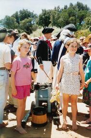
Photographs, Fuji Film, Re-enactment of the Landing of George Bass, 01/1998
... Phillip Island and District Historical Society Inc. phillip-island-and-the-bass-coast A Plaque was erected on the occassion of the re-enactment. The wording is as follows: "In Recognition of a brave adventure on January 5 1998. Five men: Bern Cuthbertson (skipper), Tom O'Byrne (first mate), Craig Dixon, Rick McMahon and Geoff Zwan, landed in Flinders after 4 weeks at sea having rowed and sailed from Darling Harbour Sydney in the 'Elizabeth', a nine metre whale boat. This voyage re-enacted the discovery and naming of Western Port ...A Plaque was erected on the occassion of the re-enactment. The wording is as follows: "In Recognition of a brave adventure on January 5 1998. Five men: Bern Cuthbertson (skipper), Tom O'Byrne (first mate), Craig Dixon, Rick McMahon and Geoff Zwan, landed in Flinders after 4 weeks at sea having rowed and sailed from Darling Harbour Sydney in the 'Elizabeth', a nine metre whale boat. This voyage re-enacted the discovery and naming of Western Port by Royal Navy Surgeon George Bass and his crew of five in 1798." They rowed an 8.7m long open whale boat some 1930 km from Port Jackson (Sydney).A collection of colour photographs taken at the re-enactment of the landing of George Bass. Showing "Sailors", a Canon, inside the boat, boats on the water and spectators on the foreshore.bass landing re-enactment 1998, george bass, san remo, p & e king -
 Phillip Island and District Historical Society Inc.
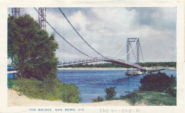
Postcard Folder, Murray Views, San Remo, c 1950 - 1960
... 268-01 The Bridge San Remo Vic 268-02 Back Beach San Remo Vic (actually says "Black Beach") 268-03 Panorama from Lookout, San Remo, Vic. 268-04 Looking towards San Remo from Phillip Island, Vic. 268-05 The Pier from Bridge, San Remo, Vic. 268-06 San Remo from Newhaven, Vic. 268-07 Western Port Hotel, San Remo, Vic. 268-08 Entrance to Main Street, San Remo, Vic. 268-09 Koala Bears 268-10 San Remo Hotel, San Remo, Vic. 268-11 the Pier and Bridge, San Remo, Vic. 268-12 Main Street, San Remo, Vic....Phillip Island and District Historical Society Inc. phillip-island-and-the-bass-coast Donated by Ruth McConvey san remo victoria australia suspension bridge san remo/phillip island ruth mcconvey 268-01 The Bridge San Remo Vic 268-02 Back Beach San Remo Vic (actually says "Black Beach") 268-03 Panorama from Lookout, San Remo, Vic. 268-04 Looking towards San Remo from Phillip Island, Vic. 268-05 The Pier from Bridge, San Remo, Vic. 268-06 San Remo from Newhaven, Vic. 268-07 Western Port Hotel, San Remo, Vic. 268-08 Entrance to Main Street, San Remo, Vic. 268-09 Koala Bears 268-10 San Remo Hotel, San Remo, Vic. 268-11 the Pier and Bridge, San Remo, Vic. 268-12 Main Street, San Remo, Vic. ...Donated by Ruth McConveyPostcard Folder with 6 coloured photographs and 6 black & white photographs of San Remo, Victoria.268-01 The Bridge San Remo Vic 268-02 Back Beach San Remo Vic (actually says "Black Beach") 268-03 Panorama from Lookout, San Remo, Vic. 268-04 Looking towards San Remo from Phillip Island, Vic. 268-05 The Pier from Bridge, San Remo, Vic. 268-06 San Remo from Newhaven, Vic. 268-07 Western Port Hotel, San Remo, Vic. 268-08 Entrance to Main Street, San Remo, Vic. 268-09 Koala Bears 268-10 San Remo Hotel, San Remo, Vic. 268-11 the Pier and Bridge, San Remo, Vic. 268-12 Main Street, San Remo, Vic.san remo victoria australia, suspension bridge san remo/phillip island, ruth mcconvey -
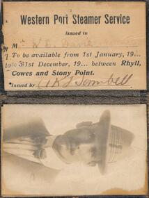 Phillip Island and District Historical Society Inc.
Document - Travel ticket
... Phillip Island and District Historical Society Inc. phillip-island-and-the-bass-coast Donated by Isabella Newbury Western Port Steamer Service Travel ticket Rhyll Cowes Stony Point W.D.Davies + family Western Port Steamer Service / Issued to Mr. ...Donated by Isabella NewburyWestern Port Steamers Service Season Ticket. Issued to W D Davie & family to be available from 1st January 19------ to 31 December 19 ------ between Rhyll, Cowes & Stony Point. Issued by A. K. Sambell. Includes PhotographWestern Port Steamer Service / Issued to Mr. W D. Davie. & family / To be available from 1st January, 19... / to 31st December, 19... between Rhyll, / Cowes and Stony Point. / Issued by A. K. Sambellwestern port steamer service, travel ticket, rhyll, cowes, stony point, w.d.davies + family -
Phillip Island and District Historical Society Inc.
Book, Western Port chronology 1798-1839 : exploration to settlement, 1984
... Phillip Island and District Historical Society Inc. phillip-island-and-the-bass-coast Extracts from log books and journals of explorers and travellers from the time George Bass entered and sketched the harbour in 1798, combined with rare charts and plates. This compilation brings life to European activity at Western Port ...Extracts from log books and journals of explorers and travellers from the time George Bass entered and sketched the harbour in 1798, combined with rare charts and plates. This compilation brings life to European activity at Western Port during the thirty-seven years that preceded Melbourne's founding. xiv, 110 p. : ill., facsims., maps ; 24 cm. ISBN 0959065202 -
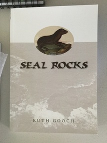 Phillip Island and District Historical Society Inc.
book, Ruth Gooch, Seal Rocks and Victoria's primitive beginnings, 2008
... Phillip Island and District Historical Society Inc. phillip-island-and-the-bass-coast seal rocks local aboriginal history sealing western port Stamped Phillip Island & District Historical Society ix, 166 p. : ill., maps, ports. ; 25 cm. ...ix, 166 p. : ill., maps, ports. ; 25 cm. Includes index. Bibliography: p. 151-159. Stamped Phillip Island & District Historical Societyseal rocks, local aboriginal history, sealing, western port