Showing 6 items matching "wet gully"
-
 Eltham District Historical Society Inc
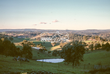
Slide - Photograph, Wet Gully, Diamond Creek, c.May 1988
... Wet Gully, Diamond Creek......wet gully...Wet Gully (local name) between Eltham and Diamond Creek, bound by Reynolds and Lorimer roads, Diamond Creek, May 1988...Eltham District Historical Society Inc 728 Main Rd Eltham melbourne Wet Gully (local name) between Eltham and Diamond Creek, bound by Reynolds and Lorimer roads, Diamond Creek, May 1988 Diamond Creek Lorimer Road Reynolds Road wet gully Process Date MAY 88M 35mm colour positive transparency (2 of 36) Mount - Kodak Kodachrome Wet Gully, Diamond Creek Slide Photograph ...Wet Gully (local name) between Eltham and Diamond Creek, bound by Reynolds and Lorimer roads, Diamond Creek, May 198835mm colour positive transparency (2 of 36) Mount - Kodak KodachromeProcess Date MAY 88Mdiamond creek, lorimer road, reynolds road, wet gully -
 Eltham District Historical Society Inc
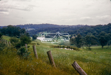
Photograph, Wet Gully (local name) between Eltham and Diamond Creek, bound by Reynolds and Lorimer roads, Diamond Creek, c.November 1964, 1964c
... Wet Gully (local name) between Eltham and Diamond Creek, bound by Reynolds and Lorimer roads, Diamond Creek, c.November 1964...Diamond Creek, Lorimer Road, Reynolds Road, Wet Gully...Eltham District Historical Society Inc 728 Main Rd Eltham melbourne Diamond Creek, Lorimer Road, Reynolds Road, Wet Gully Inscribed (c) and RY (W Gully) 35mm Colour positive transparency Mount - Ilford Ilfochrome Card Wet Gully (local name) between Eltham and Diamond Creek, bound by Reynolds and Lorimer roads, Diamond Creek, c.November 1964 Photograph ...35mm Colour positive transparency Mount - Ilford Ilfochrome CardInscribed (c) and RY (W Gully)diamond creek, lorimer road, reynolds road, wet gully -
 Eltham District Historical Society Inc
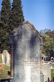
Negative - Photograph, Harry Gilham, Grave of Abraham and Ann Taylor, also Mary Taylor, Eltham Cemetery, Victoria, Sep 2009
... In January 1875 a lease issued to Abraham Taylor for the land one chain wide each side at the gully named ‘Wet Gully’ was excluded. In August 1881 Abraham Taylor paid up all fees and applied for a Crown grant. ...In January 1875 a lease issued to Abraham Taylor for the land one chain wide each side at the gully named ‘Wet Gully’ was excluded. In August 1881 Abraham Taylor paid up all fees and applied for a Crown grant. ...Abraham Taylor was born 20 October 1811 in Derrycarn, Drumcree Parish, County Armagh, Ireland, the son of Richard William Taylor and Annie Abraham. He married Ann McClelland on 19 February 1852 in Dumcree. They emigrated to Australia arriving in Geelong aboard the Ann Thompson on Christmas Day, 1852. His younger sisters Mary and Martha and brother William John all having separately preceded them in 1851 and 1852. Abraham and Ann settled in Little Eltham, Abraham was recorded as being 40 years of age and Ann, 36. They made their home and living as an orchardist and gardener where they had three sons, William John (1853 Little Eltham), Richard (1855 Eltham) and Robert David (1857 Eltham), tow of whom became Councillors of the Shire of Eltham; William (1890-1911) and Robert David (1911-1920). In June 1871, Abraham Taylor, Eltham gardener, applied for a 120-acre allotment half a mile northeast of the Research Gully Hotel on June 30, 1871. A license was issued to him January 30, 1872, for 114 acres, being Allotment 8, Section 18, the balance of 6 acres being retained for reserve. He built on the land a two roomed dwelling of slabs and palings. He and his family lived there or at their 6 ½ acre Eltham property, which was used for orchard and garden as a residence. In January 1875 a lease issued to Abraham Taylor for the land one chain wide each side at the gully named ‘Wet Gully’ was excluded. In August 1881 Abraham Taylor paid up all fees and applied for a Crown grant. He vainly requested that the grant be issued to his son, Robert David Taylor, Eltham however the grant was in fact issued to Abraham Taylor, Eltham, gardener. Abraham died at home on June 1, 1890. He was greatly respected by all who knew him. His sister Mary predeceased him 1873and is also buried at Eltham cemetery. Wife Ann died at home 1 September, 1893 and was buried with him. In Loving Remembrance of Abraham Taylor Who died June 1st 1890 Aged 80 years Also Ann Taylor Wife of the above Who died September 1st 1893 Aged 75 years Also Mary Taylor Who died September 22nd 1873 Aged 45 yearsRoll of 35mm colour negative film, 6 stripsKodak GC 400-9eltham cemetery, gravestones, abraham taylor, ann taylor, mary taylor -
 The Beechworth Burke Museum
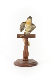
Animal specimen - Satin Flycatcher, Trustees of the Australian Museum, 1860-1880
... These birds prefer to reside in tall forests and are fond of wetter habitats like forested gullies but not rainforests. ...These birds prefer to reside in tall forests and are fond of wetter habitats like forested gullies but not rainforests. ...The Satin Flycatcher is a small and energetic bird commonly found along the east coast of Australia from far northern Queensland to Tasmania. They are also located in south-eastern South Australia and New Guinea. These birds prefer to reside in tall forests and are fond of wetter habitats like forested gullies but not rainforests. These birds are dimorphic, meaning male and females have distinct forms. The male Satin Flycatcher is blue-black in colouring while the female are brown-grey with a distinct orange band on the chin, neck and breast. This specimen is part of a collection of almost 200 animal specimens that were originally acquired as skins from various institutions across Australia, including the Australian Museum in Sydney and the National Museum of Victoria (known as Museums Victoria since 1983), as well as individuals such as amateur anthropologist Reynell Eveleigh Johns between 1860-1880. These skins were then mounted by members of the Burke Museum Committee and put-on display in the formal space of the Museum’s original exhibition hall where they continue to be on display. This display of taxidermy mounts initially served to instruct visitors to the Burke Museum of the natural world around them, today it serves as an insight into the collecting habits of the 19th century.This specimen is part of a significant and rare taxidermy mount collection in the Burke Museum. This collection is scientifically and culturally important for reminding us of how science continues to shape our understanding of the modern world. They demonstrate a capacity to hold evidence of how Australia’s fauna history existed in the past and are potentially important for future environmental research. This collection continues to be on display in the Museum and has become a key part to interpreting the collecting habits of the 19th century.This female Satin Flycatcher is stylised on a wooden platform with a paper tag attached to its leg. This specimen has small glass eyes, wings positioned to its sides and a long straight tail. The colouring on this bird is a brown-grey and cream colour. It has patch of orange feathers on the neck and chin which identify the gender of this specimen. The male has glossy blue-black colouring and lack the orange plumage.33A. / Shining Flycatcher - See Catalogue, Page 13. / 50 /taxidermy mount, taxidermy, animalia, burke museum, beechworth, australian museum, skin, reynell eveleigh johns, bird, australian birds, satin flycatcher, small bird, flycatcher -
 Eltham District Historical Society Inc
Photograph - Digital Photograph, Alan King, Kinglake National Park, 27 March 2008
... Around Jehosaphat Gully are wet and dry forest, fern gullies and banksia. ...Around Jehosaphat Gully are wet and dry forest, fern gullies and banksia. ...Fern gullies around Jehosaphat Gully Covered under National Estate. Published: Nillumbik Now and Then / Marguerite Marshall 2008; photographs Alan King with Marguerite Marshall.; p125 The magnificent Kinglake National Park, fringing Nillumbik’s north, is the largest national park close to Melbourne. Thanks to the vision and hard work of a band of local people, the park was created from what was rapidly becoming degraded land. Seeing a threat to Kinglake’s indigenous flora and fauna, several prominent local people campaigned for a national park, which was established in 1928.1 Since then, the park has grown through donations and acquisitions of land, from around 13,800 acres of land (5585ha) to 22,360 hectares. The Sugarloaf and Everard Blocks – of almost 8000 hectares – stand in Nillumbik and the park extends into Mitchell and Murrundindi Shires and the City of Whittlesea. Mt Everard commemorates William Hugh Everard, State member for Evelyn when the park was established. Before 1928, European settlers had degraded the Kinglake area, which was named after the celebrated English author and lawyer, Alexander William Kinglake. Remains of gold shafts and diggings in the park are reminders of Kinglake’s first settlers, who hoped to strike it rich at the gold diggings. But like other gold fields in this shire, they proved not very lucrative and soon timber cutting replaced mining in importance. However, before long, the accessible timber supply ran out, so in the 1920s agriculture took over – particularly potatoes and berry fruits – which involved large-scale clearing.2 The park’s instigator was retired Melbourne University Professor of Music, William Laver.3 As chair of the Kinglake Progress Association he began negotiations to have crown lands on the southern scarp of the Great Dividing Range reserved as a national park. Even before the park was proclaimed, from 1927, KPA members cut tracks to the major scenic points. Professor Laver was one of several people who gave land for the park, donating around 50 acres (20ha), including the Jehosaphat Gully.4 Laver chaired the park’s first Committee of Management, which raised money to employ a ranger and provide facilities, including tracks and roads for fire protection vehicles, toilets and shelters. The committee charged fees for firewood collection, some grazing of livestock, and visitor entrance, and obtained small State Government and Eltham Shire grants. In 1957 the State Government provided revenue for national parks. Then, in 1975, the State Government took over the management and the Committee of Management became an advisory committee, which disbanded in 1978. Originally, the park covered crown land in the Shires of Eltham and Whittlesea; then Wombelano Falls in Yea and other areas were added. In 1970 the park extended into the Shires of Eltham, Healesville, Whittlesea and Yea.5 Bush fires have been an ongoing problem. In 1939 hundreds of eucalypts and acacias had to be sown around the Jehosaphat Gully to rejuvenate the forest. To manage bushfires, the Committee of Management, then the State Government, worked closely with the Forestry Commission, shire councils and local fire brigades. Early national parks focussed on recreation. But by the 1980s, conservation, education and scientific research became more important, playing a vital role in preserving representative samples of the natural environment. Each year many thousands of people use the park’s extensive network of walking tracks amongst the protected plant and animal life as well as camping, cycling and horse riding. The park, along the slopes of the Great Dividing Range, has lookouts revealing magnificent views of the Melbourne skyline, Port Phillip Bay, the Yarra Valley and the You Yangs. Vegetation in the Masons Falls area includes messmate forest, Austral grass-trees, ferns and Hazel Pomaderris. In spring, orchids, lilies, everlasting daisies, correas, grevillea and heath appear. Around Jehosaphat Gully are wet and dry forest, fern gullies and banksia. Animal life includes wallabies, kangaroos, koalas, echidnas, possums, gliders and bandicoots. Male lyrebirds can be heard mimicking in the Jehosaphat Gully, particularly in the Everard Block in winter.This collection of almost 130 photos about places and people within the Shire of Nillumbik, an urban and rural municipality in Melbourne's north, contributes to an understanding of the history of the Shire. Published in 2008 immediately prior to the Black Saturday bushfires of February 7, 2009, it documents sites that were impacted, and in some cases destroyed by the fires. It includes photographs taken especially for the publication, creating a unique time capsule representing the Shire in the early 21st century. It remains the most recent comprehenesive publication devoted to the Shire's history connecting local residents to the past. nillumbik now and then (marshall-king) collection, kinglake national park, jehosaphat gully -
 Bendigo Historical Society Inc.
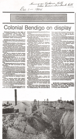
Newspaper - LONG GULLY HISTORY GROUP COLLECTION: COMMUNITY FOCUS - COLONIAL BENDIGO ON DISPLAY
... Gully History Group - Community Focus - Colonial Bendigo on display... Bendigo Art Gallery... George Rowe... S T Gill... Alex Fox... Nicholas Caire... Wet...Wet Plate Photography, Thomas Ham, Edwin Stocqueler and Ludwig Becker. There is also a photo by Nicholas Caire, taken 1875. showing the excavation of quartz reef and mine buildings near Iron bark Hill. Newspaper LONG GULLY ...Copy of a newspaper article titled Colonial Bendigo on display. Date written at the top of the page Dec 1 - 1984. Article mentions an exhibition organised by the Bendigo Art Gallery of the early photographers on the gold field. Wet plate photography was used. Other mediums were also used such as engraving, artists drawings, lithography, water colours and diorama. Artists mentioned are George Rowe, S T Gill, Alex Fox, Nicholas Caire, Wet Plate Photography, Thomas Ham, Edwin Stocqueler and Ludwig Becker. There is also a photo by Nicholas Caire, taken 1875. showing the excavation of quartz reef and mine buildings near Iron bark Hill.bendigo, history, long gully history group, the long gully history group - community focus - colonial bendigo on display, bendigo art gallery, george rowe, s t gill, alex fox, nicholas caire, wet plate photography, thomas ham, edwin stocqueler, the advertiser, ludwig becker, burke and wills expedition, mine buildings near ironbark hill, victoria hill