Showing 172 items matching "wetland"
-
 Friends of Ballarat Botanical Gardens History Group
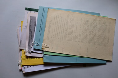
Work on paper - Listing of Wetland Plants, Ballarat Botanical Gardens Wetland Plants, Unknown
... Ballarat Botanical Gardens Wetland Plants...While there are drawings of wetlands' plants and the classification of each plant, it is not clear as to how many of these plants are to be found in the Ballarat Botanical Gardens, at this time....Ballarat Botanical Gardens Wetland Plants Work on paper Listing of Wetland Plants ...While there are drawings of wetlands' plants and the classification of each plant, it is not clear as to how many of these plants are to be found in the Ballarat Botanical Gardens, at this time.As the Wetlands, in the northern section of the Ballarat Botanical Gardens are an important and unique section of the Gardens today, it is important to know something of the flora in that area.3 double sheets with black and white drawings of plants on the left hand side of each half page with the classification for each plant.Joan Garner is written in blue biro on the back of the first sheet.john garner, doctor, john garner collection, ballarat botanic gardens, north garden reserve, wetlands, wetlands' plants, drawings of wetlands plants, classification of wetland plants -
 Croydon Conservation Society Inc.
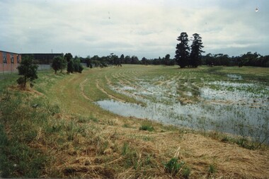
Photograph, Croydon Wetlands Flood January/February 2000
... Nine 6 x 4" photos of Croydon Wetlands in flood ...Handwritten inscription on back of images: Photo 2 - Croydon Wetlands Jan-Feb 2000 Photo 3 - Croydon Wetlands in flood Jan-Feb 2000 Photo 4 - Corydon Wetlands Jan-Feb 2000 Photo 5 - Croydon Wetlands Jan-Feb 2000 Photo 6 - Croydon Wetlands Jan-Feb 2000 Photo 7 - Croydon Wetlands Jan-Feb 2000 Photo 8 - Rubbish floating in Croydon Wetlands Jan - Feb 2000 Photo 9 - Croydon Wetlands Jan - Feb 2000...Croydon melbourne Handwritten inscription on back of images: Photo 2 - Croydon Wetlands Jan-Feb 2000 Photo 3 - Croydon Wetlands in flood Jan-Feb 2000 Photo 4 - Corydon Wetlands Jan-Feb 2000 Photo 5 - Croydon Wetlands Jan-Feb 2000 Photo 6 - Croydon Wetlands Jan-Feb 2000 Photo 7 - Croydon Wetlands Jan-Feb 2000 Photo 8 - Rubbish floating in Croydon Wetlands Jan - Feb 2000 Photo 9 - Croydon Wetlands Jan - Feb 2000 Nine 6 x 4" photos of Croydon Wetlands in flood Croydon Wetlands Flood January/February 2000 Photograph ...Nine 6 x 4" photos of Croydon Wetlands in flood Handwritten inscription on back of images: Photo 2 - Croydon Wetlands Jan-Feb 2000 Photo 3 - Croydon Wetlands in flood Jan-Feb 2000 Photo 4 - Corydon Wetlands Jan-Feb 2000 Photo 5 - Croydon Wetlands Jan-Feb 2000 Photo 6 - Croydon Wetlands Jan-Feb 2000 Photo 7 - Croydon Wetlands Jan-Feb 2000 Photo 8 - Rubbish floating in Croydon Wetlands Jan - Feb 2000 Photo 9 - Croydon Wetlands Jan - Feb 2000 -
 Croydon Conservation Society Inc.
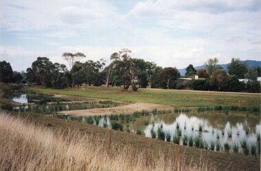
Photograph, Croydon Wetlands - Norton Road end, late 1999
... Three 6x4" colour photos Croydon Wetlands, late 1999, Norton Rd end of the park plus three digital (PNG) photos only....On reverse, handwritten notes: Image 1 Wetlands, late 1999, Norton Rd end of the park. ...Image 2 Wetlands, late 1999, Norton Rd end of the park. ...Three 6x4" colour photos Croydon Wetlands, late 1999, Norton Rd end of the park plus three digital (PNG) photos only.On reverse, handwritten notes: Image 1 Wetlands, late 1999, Norton Rd end of the park. Image 2 Wetlands, late 1999, Norton Rd end of the park. Image 3 Wetlands, late 1999, Dandenong Creek Site, Norton Rd end park, Croydon. -
 Whitehorse Historical Society Inc.
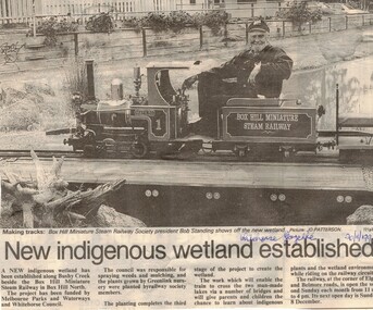
Article, New indigenous wetland established, 20/11/1996 12:00:00 AM
... New indigenous wetland established...Whitehorse Historical Society Inc. 2-10 Deep Creek Road Mitcham melbourne miniature railways bushy creek reserve box hill miniature steam railway standing robert Whitehorse Gazette 20 November 1996 on Box Hill Miniature steam railway, Illustrated article from Whitehorse Gazette 20 November 1996 on Box Hill Miniature steam railway, Box Hill North, New indigenous wetland established Article Article ...Whitehorse Gazette 20 November 1996 on Box Hill Miniature steam railway,Illustrated article from Whitehorse Gazette 20 November 1996 on Box Hill Miniature steam railway, Box Hill North,Whitehorse Gazette 20 November 1996 on Box Hill Miniature steam railway,miniature railways, bushy creek reserve, box hill miniature steam railway, standing, robert -
 Greensborough Historical Society
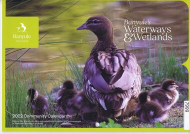
Calendar, Banyule City Council, Banyule Community Calendar 2022: Banyule's Waterways & Wetlands, 2022
... The 2022 calendar contains action photographs of local waterways and wetlands. Some council services are detailed in the back pages....Illustrations of local waterways and wetlands. ...The annual report is a record of the activities and services in the Banyule City Council area. banyule city council banyule community calendar rivers wetlands 30 pages. Colour illustrations. Illustrations of local waterways and wetlands. ...This community calendar is distributed to residents of the City of Banyule each year. Each year it focusses on an aspect of the local community. The 2022 calendar contains action photographs of local waterways and wetlands. Some council services are detailed in the back pages.The annual report is a record of the activities and services in the Banyule City Council area.30 pages. Colour illustrations. Illustrations of local waterways and wetlands. banyule city council, banyule community calendar, rivers, wetlands -
 Federation University Historical Collection
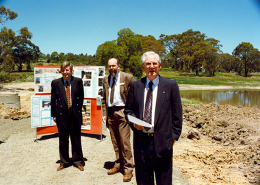
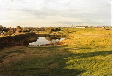
Photograph - Photograph - Colour, Canadian Wetlands at the Ballarat Technology Centre, c2000
... During the construction of the Ballarat Technology Park a wetland area was protected. Associated with Canadian Creek it is known as the Canadian Wetland/...Two photographs showing the Canadian Wetlands at the Ballarat Technology Park. .1) Left to Right, Rob McLellan (Victorian Minister), Martin Westbrooke (Science/Engineering faculty); David James (University of Ballarat Vice Chancellor) .2) Left to Right, Rob McLellan (Victorian Minister), David James (University of Ballarat Vice Chancellor)...During the construction of the Ballarat Technology Park a wetland area was protected. Associated with Canadian Creek it is known as the Canadian Wetland/ david james mclellan westbrooke martin westbrooke ron mclellan canadian wetlands ballarat technology centre Two photographs showing the Canadian Wetlands at the Ballarat Technology Park. .1) Left to Right, Rob McLellan (Victorian Minister), Martin Westbrooke (Science/Engineering faculty); David James (University of Ballarat Vice Chancellor) .2) Left to Right, Rob McLellan (Victorian Minister), David James (University of Ballarat Vice Chancellor) Canadian Wetlands at the Ballarat Technology Centre Photograph Photograph - Colour ...During the construction of the Ballarat Technology Park a wetland area was protected. Associated with Canadian Creek it is known as the Canadian Wetland/Two photographs showing the Canadian Wetlands at the Ballarat Technology Park. .1) Left to Right, Rob McLellan (Victorian Minister), Martin Westbrooke (Science/Engineering faculty); David James (University of Ballarat Vice Chancellor) .2) Left to Right, Rob McLellan (Victorian Minister), David James (University of Ballarat Vice Chancellor)david james, mclellan, westbrooke, martin westbrooke, ron mclellan, canadian wetlands, ballarat technology centre -
Federation University Historical Collection
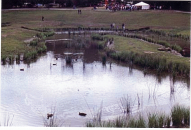
Document - Report, University of Ballarat Canadian Wetlands Project Report, 2000, 04/2000
... - Waterbirds move in and the germination of native wetland plant species begins 2000 - Stage 2 plans developed, including additional walkways, bird hides and interpretation. ...Three page report on the University of Ballarat Canadian Wetlands Project. Direct funding for the project was provided by the University of Ballarat; The Department of Employment, Workplace Relations and Small Business and the Corangamite Catchment Authority.... - Waterbirds move in and the germination of native wetland plant species begins 2000 - Stage 2 plans developed, including additional walkways, bird hides and interpretation. ballarat technology park canadian wetlands ian howe mount helen Mount Helen Campus Three page report on the University of Ballarat Canadian Wetlands Project. ...1992 - Property purchased fronting Geelong Road, Mount Helen 1994 - Additional adjoining property purchased 1995 - Wetlands included in the Corporate Plan for the area 1997 - Launch of Wetlands Development by Minister Maclennan 1998 - Preliminary planning and plant identification underway - Contract signed for funding 1999 - Stage 1; Planning finalised, earthworks undertaken and weed infestation assaulted - "Work for the Dole" project undertaken - Deluge of rain on Boxing Day provides the centrepiece f the project, the just-completed dam, with a body of water to overflowing level. - Waterbirds move in and the germination of native wetland plant species begins 2000 - Stage 2 plans developed, including additional walkways, bird hides and interpretation. Three page report on the University of Ballarat Canadian Wetlands Project. Direct funding for the project was provided by the University of Ballarat; The Department of Employment, Workplace Relations and Small Business and the Corangamite Catchment Authority.ballarat technology park, canadian wetlands, ian howe, mount helen, mount helen campus -
 Darebin Parklands Association
Rockbeare Park and Darebin Creek, August 1974, 1974
... In 1972 Ivanhoe Progress Association planned to fill in the wetlands because they felt it bred mosquitos, and they obtained a grant for this work to take place. ...B&W photograph. Shows wetlands and Darebin Creek. Albion Reid land on fore bank. ...Shows wetlands and Darebin Creek. Albion Reid land on fore bank. ...In 1972 Ivanhoe Progress Association planned to fill in the wetlands because they felt it bred mosquitos, and they obtained a grant for this work to take place. Darebin Parklands Association stormed the meeting to get this decision reversed, and the wetlands were never filled in.B&W photograph. Shows wetlands and Darebin Creek. Albion Reid land on fore bank. View from the north with panorama of Kew in the distance This item and all other Darebin Parklands Association archival material is now held by State Library Victoria (Accession No: YMS 13746). Please contact State Library Victoria if access is required. -
 Surrey Hills Historical Society Collection
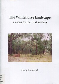
Book, The Whitehorse landscape as seen by the first settlers, 2011
... This book describes the type of vegetation that covered the landscapes of the area, where streams flowed, when wetlands occurred and which species of mammals, birds, reptiles, fish & insects inhabited the area. ...This book describes the type of vegetation that covered the landscapes of the area, where streams flowed, when wetlands occured and which species of mammals, birds, reptitles, fish & isects inhabited the area. ...Surrey Hills Historical Society Collection 190A Canterbury Road Canterbury melbourne This book describes the type of vegetation that covered the landscapes of the area, where streams flowed, when wetlands occurred and which species of mammals, birds, reptiles, fish & insects inhabited the area. ...This book describes the type of vegetation that covered the landscapes of the area, where streams flowed, when wetlands occurred and which species of mammals, birds, reptiles, fish & insects inhabited the area. Author: Gary Presland.This book describes the type of vegetation that covered the landscapes of the area, where streams flowed, when wetlands occured and which species of mammals, birds, reptitles, fish & isects inhabited the area. Author: Gary Presland.whitehorse region, natural history, vegetation, fauna, geology, (mr) gary presland -
Port Melbourne Historical & Preservation Society
Photograph - Port Melbourne foreshore, Elizabeth Cromb, 1990s
... Photographed by Betty CROMB, who lived at corner of The Boulevard and Barak Road, after wetlands had been created by the cleanup of the BP site. ...View toward inland beacon and temporary wetlands soon to become Beacon Cove (The supplementray file is a letter from the donor)...Port Melbourne Historical & Preservation Society Port Melbourne Town Hall 333 Bay Street Port Melbourne melbourne Photographed by Betty CROMB, who lived at corner of The Boulevard and Barak Road, after wetlands had been created by the cleanup of the BP site. ...Photographed by Betty CROMB, who lived at corner of The Boulevard and Barak Road, after wetlands had been created by the cleanup of the BP site. Before the building of Beacon Cove.One of two colour photos Port Melbourne foreshore, taken and sent by Elizabeth CROMB: Beacon Cove site pre-development. City skyline in background. View toward inland beacon and temporary wetlands soon to become Beacon Cove (The supplementray file is a letter from the donor)natural environment, beacons, town planning, built environment, piers and wharves - station pier, piers and wharves - princes pier, transport - ferries, elizabeth cromb, beacon cove -
 Darebin Parklands Association
Wetlands near BBQ area. 1982, Darebin Parklands Association, 1982
... Annotated on back. [Wetlands near BBQ area 1982]...Please contact State Library Victoria if access is required. Wetlands near BBQ area. 1982 Darebin Parklands Association ...Colour photograph This item and all other Darebin Parklands Association archival material is now held by State Library Victoria (Accession No: YMS 13746). Please contact State Library Victoria if access is required.Annotated on back. [Wetlands near BBQ area 1982] -
 Warrnambool and District Historical Society Inc.
Administrative record (Collection) - Warrnambool City Council Administrative Records, Warrnambool City Council Officers, 1990s
... This is a collection of records of the Warrnambool City Council from the 1990s mainly dealing with the sub committees concerning the environment, business and street scape (City Plans, Street Life, Coastal Wetlands, Landcare, Foreshore, Shop Trading etc). ...Two A3 archival envelopes containing information on Foreshore etc., five booklets containing reports on City Plans, Council Strategies etc and 15 Reports (Shop Trading, Coastal Wetlands, Foreshore, Landcare etc)...Warrnambool and District Historical Society Inc. 2 Gilles Street (south of Merri St) Warrnambool great-ocean-road This is a collection of records of the Warrnambool City Council from the 1990s mainly dealing with the sub committees concerning the environment, business and street scape (City Plans, Street Life, Coastal Wetlands, Landcare, Foreshore, Shop Trading etc). ...Warrnambool City Council Records collected by a member of a Council Advisory Committee.Collection of Warrnambool City Council records of the 1990sIn folders and archival envelopes in an A3 archival boxTwo A3 archival envelopes containing information on Foreshore etc., five booklets containing reports on City Plans, Council Strategies etc and 15 Reports (Shop Trading, Coastal Wetlands, Foreshore, Landcare etc)warrnambool city council, warrnambool city council strategies and planswarrnambool city council, warrnambool city council strategies and plans -
 Darebin Parklands Association
Darebin Parklands Wetlands August 1985, Darebin Parklands Association et al, 1985
... Annotated on back [Wetlands near BBQ area. Brad Hales Aug '85]...Darebin Parklands Wetlands August 1985 Darebin Parklands Association Brad Hales ...Colour photograph This item and all other Darebin Parklands Association archival material is now held by State Library Victoria (Accession No: YMS 13746). Please contact State Library Victoria if access is required.Annotated on back [Wetlands near BBQ area. Brad Hales Aug '85] -
 Whitehorse Historical Society Inc.
Photograph, Opening of Wurundjeri Wetlands
... Five coloured photographs of the opening of the Wurundjeri Wetlands in Blackburn South in 1992. (Three photos of wetlands and 2 of crowd under umbrellas) See also ND808...The walk is named after the Wurundjeri tribe who once lived in the area parks and reserves recreation facilities wurundjeri walk Five coloured photographs of the opening of the Wurundjeri Wetlands in Blackburn South in 1992. (Three photos of wetlands and 2 of crowd under umbrellas) See also ND808 Opening of Wurundjeri Wetlands Photograph Photograph ...Wurundjeri walk, which runs alongside Fulton Road, Blackburn South, was officially opened in 1992 by Mayor, Cr. Savaas Athan, and Wurundjeri Tribal Elder, Mrs Winnie Bridges. The walk is named after the Wurundjeri tribe who once lived in the areaFive coloured photographs of the opening of the Wurundjeri Wetlands in Blackburn South in 1992. (Three photos of wetlands and 2 of crowd under umbrellas) See also ND808parks and reserves, recreation facilities, wurundjeri walk -
 Ballarat Heritage Services
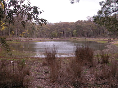
Photograph - Photograph - Colour, Clare Gervasoni, Hunt's Dam near Hepburn Springs, 27.08.2003
... Colour photorgraphs of a wetlands area known as Hunt's Dam....Ballarat Heritage Services PO Box 2209 Bakery Hill Post Office goldfields hunt's dam hepburn Colour photorgraphs of a wetlands area known as Hunt's Dam. Hunt's Dam near Hepburn Springs Photograph Photograph - Colour Clare Gervasoni ...Colour photorgraphs of a wetlands area known as Hunt's Dam.hunt's dam, hepburn -
Croydon Conservation Society Inc.
Archive, Croydon Wetlands Park - Archive Collection - Parent Record
... Archival Collection of Croydon Wetlands photographs, documents, planning etc...Croydon melbourne Archival Collection of Croydon Wetlands photographs, documents, planning etc Croydon Wetlands Park - Archive Collection - Parent Record Archive ...Archival Collection of Croydon Wetlands photographs, documents, planning etc -
 Whitehorse Historical Society Inc.
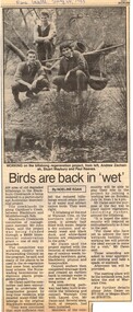
Article, Birds are back in 'wet', 20/07/1988 12:00:00 AM
... $4,000 funding through bi-centennial grant to restore wetlands at end of Waratah Street, Blackburn....Whitehorse Historical Society Inc. 2-10 Deep Creek Road Mitcham melbourne wetlands gardiners creek dates john city of nunawading waratah crescent blackburn laurel grove zachariah andrew maybury stuart reeves paul $4,000 funding through bi-centennial grant to restore wetlands at end of Waratah Street, Blackburn $4,000 funding through bi-centennial grant to restore wetlands at end of Waratah Street, Blackburn. ...$4,000 funding through bi-centennial grant to restore wetlands at end of Waratah Street, Blackburn$4,000 funding through bi-centennial grant to restore wetlands at end of Waratah Street, Blackburn.$4,000 funding through bi-centennial grant to restore wetlands at end of Waratah Street, Blackburnwetlands, gardiners creek, dates, john, city of nunawading, waratah crescent, blackburn, laurel grove, zachariah, andrew, maybury, stuart, reeves, paul -
 Federation University Historical Collection
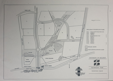
Plan - map, Ballarat Technology Park Wetlands Reserve and water retention basins, c1999
... It shows the Canadian Wetlands Researve and the water retentino.Detention Basins....It shows the Canadian Wetlands Researve and the water retentino.Detention Basins. ...Yellow A4 page with a subdivision layout of the Ballarat Technology Park. It shows the Canadian Wetlands Researve and the water retentino.Detention Basins.canadian wetlands, ballarat technology park, mount helen campus -
 Buninyong & District Historical Society
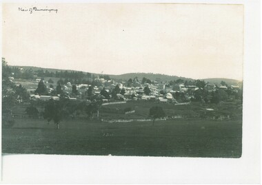
Photograph - Photo of Original Photograph, View of Buninyong looking down from south east around 1900, 1993
... Copy of B/W Photograph, View of Buninyong looking down from south east around 1900 across fields and wetland....Buninyong & District Historical Society Old Court House, Buninyong Town Hall 313 Learmonth Street Buninyong goldfields hidtoric record Buninyong View Copy of B/W Photograph, View of Buninyong looking down from south east around 1900 across fields and wetland. View of Buninyong looking down from south east around 1900 Photograph Photo of Original Photograph ...hidtoric recordCopy of B/W Photograph, View of Buninyong looking down from south east around 1900 across fields and wetland.buninyong, view -
Kew Historical Society Inc
Archive (Sub-series) - Subject File, Chandler Park (Kew), 1958
... Archive file containing an extract from a Boroondara Bulletin (2016) outlining community feedback on the concept for a wetland at Chandler Park in Kew....Typically files will contain primary and secondary sources. chandler park -- kew (vic.) parks and gardens -- kew (vic.) wetlands -- kew (vic.) Archive file containing an extract from a Boroondara Bulletin (2016) outlining community feedback on the concept for a wetland at Chandler Park in Kew. ...Various partiesReference, Research, InformationSecondary Values (KHS Imposed Order)Subject file containing an extract from a Boroondara Bulletin (2016) outlining community feedback on the concept for a wetland at Chandler Park in Kew.chandler park -- kew (vic.), parks and gardens -- kew (vic.), wetlands -- kew (vic.)chandler park -- kew (vic.), parks and gardens -- kew (vic.), wetlands -- kew (vic.) -
 Whitehorse Historical Society Inc.
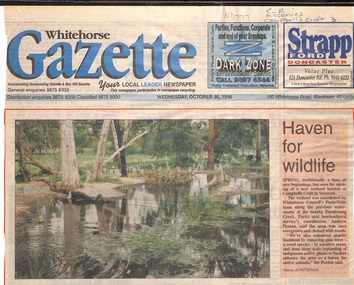
Newspaper - Article, Haven for wildlife, 30/10/1996
... 'Haven for wildlife' article on new wetland habitat at Campbells Croft, including colour photo from Whitehorse Gazette, 30 October 1996....Whitehorse Historical Society Inc. 2-10 Deep Creek Road Mitcham melbourne Including colour photo from Whitehorse Gazette, 30 October 1996. campbells croft parks and reserves 'Haven for wildlife' article on new wetland habitat at Campbells Croft. 'Haven for wildlife' article on new wetland habitat at Campbells Croft, including colour photo from Whitehorse Gazette, 30 October 1996. ...'Haven for wildlife' article on new wetland habitat at Campbells Croft.'Haven for wildlife' article on new wetland habitat at Campbells Croft, including colour photo from Whitehorse Gazette, 30 October 1996.'Haven for wildlife' article on new wetland habitat at Campbells Croft.campbells croft, parks and reserves -
 Ringwood and District Historical Society
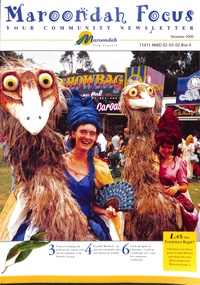
Magazine, Maroondah In Focus Council Magazine December 2000
... Maroondah In Focus newsletter includes features Scoresby Freeway push, Croydon Wetlands, Carols by Candlelight, Clock Tower revamp, INternational Business Showcase. ...Ringwood and District Historical Society 125A Warrandyte Road Ringwood North melbourne Maroondah In Focus newsletter includes features Scoresby Freeway push, Croydon Wetlands, Carols by Candlelight, Clock Tower revamp, INternational Business Showcase. ...Maroondah In Focus newsletter includes features Scoresby Freeway push, Croydon Wetlands, Carols by Candlelight, Clock Tower revamp, INternational Business Showcase. -
 Whitehorse Historical Society Inc.
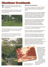
Pamphlet, Blackburn Creeklands, 1/08/1990 12:00:00 AM
... Sympathetic treatment of creek banks and preservation and regeneration of bushland will encourage wildlife, development of wetlands has encouraged water birds, provision of play equipment...Whitehorse Historical Society Inc. 2-10 Deep Creek Road Mitcham melbourne parks and reserves blacks walk kalang park furness park city of nunawading melbourne and metropolitan board of works middleborough road blackburn pakenham street blackburn road gardiners creek laburnum primary school no. 4863 Sympathetic treatment of creek banks and preservation and regeneration of bushland will encourage wildlife Sympathetic treatment of creek banks and preservation and regeneration of bushland will encourage wildlife, development of wetlands has encouraged water birds, provision of play equipment Blackburn Creeklands Pamphlet Pamphlet ...Sympathetic treatment of creek banks and preservation and regeneration of bushland will encourage wildlifeSympathetic treatment of creek banks and preservation and regeneration of bushland will encourage wildlife, development of wetlands has encouraged water birds, provision of play equipmentSympathetic treatment of creek banks and preservation and regeneration of bushland will encourage wildlifeparks and reserves, blacks walk, kalang park, furness park, city of nunawading, melbourne and metropolitan board of works, middleborough road, blackburn, pakenham street, blackburn road, gardiners creek, laburnum primary school no. 4863 -
Port Melbourne Historical & Preservation Society
Audio - PMHPS Meeting, Wasteland and Wetlands, Rob Giblett
... Rob Giblett presents "Wasteland and Wetlands" regarding Fishermens Bend and Westgate Park Duration 01:2:05 (includes meeting preliminaries) PMHPS meeting 222.02.2016...Port Melbourne Historical & Preservation Society Port Melbourne Town Hall 333 Bay Street Port Melbourne melbourne Fishermans Bend Parks and Gardens Rob Giblett Westgate Park Rob Giblett presents "Wasteland and Wetlands" regarding Fishermens Bend and Westgate Park Duration 01:2:05 (includes meeting preliminaries) PMHPS meeting 222.02.2016 Audio PMHPS Meeting, Wasteland and Wetlands, Rob Giblett ...Rob Giblett presents "Wasteland and Wetlands" regarding Fishermens Bend and Westgate Park Duration 01:2:05 (includes meeting preliminaries) PMHPS meeting 222.02.2016fishermans bend, parks and gardens, rob giblett, westgate park -
Port Melbourne Historical & Preservation Society
Audio - PMHPS AGM, Melbourne Wetlands and Water, Prof Don Garden, John Kirby, 22 Aug 2016
... Prof Don Garden talks about "Melbourne Wetlands and Water" - a taste of environmental history PMHPS AGM Duration 1:09:55 including meeting preliminaries...Port Melbourne Historical & Preservation Society Port Melbourne Town Hall 333 Bay Street Port Melbourne melbourne Environment Professor Don Garden Prof Don Garden talks about "Melbourne Wetlands and Water" - a taste of environmental history PMHPS AGM Duration 1:09:55 including meeting preliminaries Audio PMHPS AGM, Melbourne Wetlands and Water, Prof Don Garden John Kirby ...Prof Don Garden talks about "Melbourne Wetlands and Water" - a taste of environmental history PMHPS AGM Duration 1:09:55 including meeting preliminariesenvironment, professor don garden -
 Whitehorse Historical Society Inc.
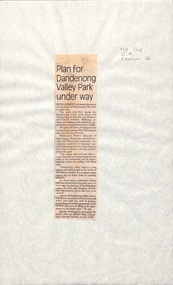
Newspaper - Article, Plan for Dandenong Valley park under way, 1/06/1992
... Development of park along Dandenong Creek from Knox and Nunawading to Rowville and Mulgrave featuring wetlands, billabongs, cycling and walking tracks, bushland, picnic facilities and wildlife....Whitehorse Historical Society Inc. 2-10 Deep Creek Road Mitcham melbourne dandenong creek melbourne water floyd jeff dandenong valley metropolitan park chesterfield chris parks and reserves Development of park along Dandenong Creek from Knox and Nunawading to Rowville and Mulgrave featuring wetlands, billabongs, cycling and walking tracks, bushland, picnic facilities and wildlife. ...Development of park along Dandenong Creek from Knox and Nunawading to Rowville and Mulgrave featuring wetlands, billabongs, cycling and walking tracks, bushland, picnic facilities and wildlife.dandenong creek, melbourne water, floyd, jeff, dandenong valley metropolitan park, chesterfield, chris, parks and reserves -
 The Beechworth Burke Museum
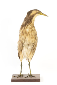
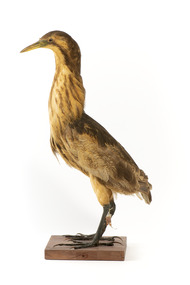
Animal specimen - Australaisn Bittern, Trustees of the Australian Museum, 1860-1880
... They can be found in wetlands, swamps and among reeds. These birds are mostly brown and yellow in colour and with short legs and a stocky body. ...This colouring makes the bird difficult to see in the dense, reedy vegetation it resides amongst in shallow freshwater wetlands. When threatened, the Australaisn Bittern will raise its bill skyward in a pose which helps it camouflage. ...They can be found in wetlands, swamps and among reeds. These birds are mostly brown and yellow in colour and with short legs and a stocky body. ...The Australaisn Bittern is a partly nocturnal bird who resides in costal and sub-coastal locations in south-west mainland Australia, south east Australia and Tasmania. They can be found in wetlands, swamps and among reeds. These birds are mostly brown and yellow in colour and with short legs and a stocky body. The "woomph" sound made by the Bittern late at night is thought to have been the origin of the traditional Aboriginal myth of the Bunyip. The Bunyip, like the Australasian Bittern, was believed to reside in reedy swamps. This specimen is part of a collection of almost 200 animal specimens that were originally acquired as skins from various institutions across Australia, including the Australian Museum and the National Museum of Victoria, as well as individuals such amateur anthropologist Reynell Eveleigh Johns between 1860-1880. These skins were then mounted by members of the Burke Museum Committee and put-on display in the formal space of the Museum’s original exhibition hall where they continue to be on display. This display of taxidermy mounts initially served to instruct visitors to the Burke Museum of the natural world around them, today it serves as an insight into the collecting habits of the 19th century. This specimen is part of a significant and rare taxidermy mount collection in the Burke Museum. This collection is scientifically and culturally important for reminding us of how science continues to shape our understanding of the modern world. They demonstrate a capacity to hold evidence of how Australia’s fauna history existed in the past and are potentially important for future environmental research. This collection continues to be on display in the Museum and has become a key part to interpreting the collecting habits of the 19th century.The Australaisn Bittern is a stocky bird with mainly yellow and brown colouring. This colouring makes the bird difficult to see in the dense, reedy vegetation it resides amongst in shallow freshwater wetlands. When threatened, the Australaisn Bittern will raise its bill skyward in a pose which helps it camouflage. This specimen has streaked yellow-brown feathers, a yellow bill and legs which are a yellow-green colour. It stands on a wooden platform.taxidermy mount, taxidermy, animalia, burke museum, beechworth, australian museum, skin, reynell eveleigh johns, bird, bunyip, myths, australaisn bittern, bittern -
 The Beechworth Burke Museum
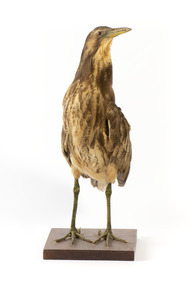
Animal specimen - Australasian Bittern, Trustees of the Australian Museum, 1860-1880
... They can be found in wetlands, swamps and among reeds. These birds are mostly brown and yellow in colour and with short legs and a stocky body. ...This colouring makes the bird difficult to see in the dense, reedy vegetation where it resides amongst the shallow freshwater wetlands. When threatened, the Australaisn Bittern will raise it's bill skyward in a pose which helps it to camouflage. ...They can be found in wetlands, swamps and among reeds. These birds are mostly brown and yellow in colour and with short legs and a stocky body. ...The Australaisn Bittern is a partly nocturnal bird who resides in costal and sub-coastal locations in south-west mainland Australia, south east Australia and Tasmania. They can be found in wetlands, swamps and among reeds. These birds are mostly brown and yellow in colour and with short legs and a stocky body. The "woomph" sound made by the Bittern late at night is thought to have been the origin of the traditional Aboriginal myth of the Bunyip. The Bunyip, like the Australasian Bittern, was believed to reside in reedy swamps. This specimen is part of a collection of almost 200 animal specimens that were originally acquired as skins from various institutions across Australia, including the Australian Museum and the National Museum of Victoria, as well as individuals such amateur anthropologist Reynell Eveleigh Johns between 1860-1880. These skins were then mounted by members of the Burke Museum Committee and put-on display in the formal space of the Museum’s original exhibition hall where they continue to be on display. This display of taxidermy mounts initially served to instruct visitors to the Burke Museum of the natural world around them, today it serves as an insight into the collecting habits of the 19th century. This specimen is part of a significant and rare taxidermy mount collection in the Burke Museum. This collection is scientifically and culturally important for reminding us of how science continues to shape our understanding of the modern world. They demonstrate a capacity to hold evidence of how Australia’s fauna history existed in the past and are potentially important for future environmental research. This collection continues to be on display in the Museum and has become a key part to interpreting the collecting habits of the 19th century.The Australaisn Bittern is a stocky bird with mainly yellow and brown colouring. This colouring makes the bird difficult to see in the dense, reedy vegetation where it resides amongst the shallow freshwater wetlands. When threatened, the Australaisn Bittern will raise it's bill skyward in a pose which helps it to camouflage. This specimen has streaked yellow-brown feathers, a yellow bill and legs which are a yellow-green colour. It stands on a wooden platform.Paper tag: ...Bittern... [Catalogu]e, page 3...taxidermy mount, taxidermy, animalia, burke museum, beechworth, australian museum, skin, reynell eveleigh johns, bird, bunyip, myths, australaisn bittern, bittern -
City of Kingston
Photograph - Colour, 29 January 1993
... The suburb borders the Edithvale-Seaford Wetlands which is the remnant site of the Carrum Carrum swamp, once the home of the Bunurong people....Landmarks include St Joseph's Church and Primary School, Chelsea Primary School, Bonbeach Station, Bonbeach Fotball Club sports playing fields and Bonbeach Life Saving Club. The Edithvale Wetlands is featured prominently to the right-hand side of the image. ...The suburb borders the Edithvale-Seaford Wetlands which is the remnant site of the Carrum Carrum swamp, once the home of the Bunurong people. ...Bonbeach is a small beachside suburb located between Chelsea and Carrum. The station was opened in 1926 and was the last to be established in the group from Aspendale to Carrum. Urban growth began after World War II. State primary and high schools were opened in 1958 on land in Breeze Street that was once occupied by The Australian Glass Manufacturers. Immediately east of the school sites is the Patterson River Golf Club. The Bonbeach sports reserve has five ovals and is home to the Bonbeach football and baseball clubs. The suburb borders the Edithvale-Seaford Wetlands which is the remnant site of the Carrum Carrum swamp, once the home of the Bunurong people.Bonbeach was originally a seaside destination for holidaymakers and the housing comprised of holiday homes and gradually more permanent residents. It was not until 1926 that Bonbeach had its own railway station. From 1906 until the late 1940s sand was quarried on the east side of the railway line and used in the manufacture of glass. The Australian Glass Manufacturers sold this land in residential blocks and Bonbeach's permanent population spread from the coastal strip across to the other side of the railway line. Laminated colour aerial photograph of the suburb of Bonbeach and also the southern section of neighbouring Chelsea within the City of Kingston. The extent of this 1993 aerial image includes: Top left - Maury Road at the south end of the Chelsea shopping Centre; Top right - Scotch Parade Chelsea Bottom left - Monica Avenue in Bonbeach; Bottom right - Patterson River Golf Club. Landmarks include St Joseph's Church and Primary School, Chelsea Primary School, Bonbeach Station, Bonbeach Fotball Club sports playing fields and Bonbeach Life Saving Club. The Edithvale Wetlands is featured prominently to the right-hand side of the image. Black typed writing on white adhesive label: No. 6662 Black typed writing on white adhesive label: 26E/6662, 29/1/93, 4.25 pm Black typed writing on white adhesive label: 29-1-93 Black typed writing on white adhesive label: P000109 Circular yellow adhesive sticker bonbeach, chelsea -
 The Beechworth Burke Museum
Animal specimen - Australasian Bittern, Trustees of the Australian Museum, 1860-1880
... They can be found in wetlands, swamps and among reeds. These birds are mostly brown and yellow in colour and with short legs and a stocky body. ...This colouring makes the bird difficult to see in the dense, reedy vegetation it resides amongst in shallow freshwater wetlands. When threatened, the Australaisn Bittern will raise its bill skyward in a pose which helps it camouflage. ...They can be found in wetlands, swamps and among reeds. These birds are mostly brown and yellow in colour and with short legs and a stocky body. ...The Australaisn Bittern is a partly nocturnal bird who resides in costal and sub-coastal locations in south-west mainland Australia, south east Australia and Tasmania. They can be found in wetlands, swamps and among reeds. These birds are mostly brown and yellow in colour and with short legs and a stocky body. The "woomph" sound made by the Bittern late at night is thought to have been the origin of the traditional Aboriginal myth of the Bunyip. The Bunyip, like the Australasian Bittern, was believed to reside in reedy swamps. This specimen is part of a collection of almost 200 animal specimens that were originally acquired as skins from various institutions across Australia, including the Australian Museum in Sydney and the National Museum of Victoria (known as Museums Victoria since 1983), as well as individuals such as amateur anthropologist Reynell Eveleigh Johns between 1860-1880. These skins were then mounted by members of the Burke Museum Committee and put-on display in the formal space of the Museum’s original exhibition hall where they continue to be on display. This display of taxidermy mounts initially served to instruct visitors to the Burke Museum of the natural world around them, today it serves as an insight into the collecting habits of the 19th century.This specimen is part of a significant and rare taxidermy mount collection in the Burke Museum. This collection is scientifically and culturally important for reminding us of how science continues to shape our understanding of the modern world. They demonstrate a capacity to hold evidence of how Australia’s fauna history existed in the past and are potentially important for future environmental research. This collection continues to be on display in the Museum and has become a key part to interpreting the collecting habits of the 19th century. This Australaisn Bittern is a stocky bird stylised in a standing position with brown colouring. This colouring makes the bird difficult to see in the dense, reedy vegetation it resides amongst in shallow freshwater wetlands. When threatened, the Australaisn Bittern will raise its bill skyward in a pose which helps it camouflage. This specimen has streaked yellow-brown feathers, a yellow bill and legs which are a yellow-green colour. It stands on a wooden platform.taxidermy mount, taxidermy, animalia, burke museum, beechworth, australian museum, skin, reynell eveleigh johns, bird, bunyip, myths, australaisn bittern, bittern