Showing 95 items matching "wheat - agriculture"
-
 Federation University Historical Collection
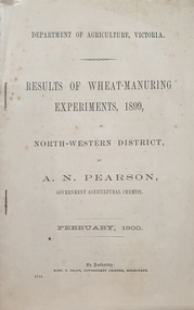
Booklet, A.N. Pearson (Department of Agriculture), Results of Wheat-Manuring Experiments, 1899, 02/1900
... wheat...agriculture...Barker Library (top floor) Mount Helen goldfields a.n. pearson manure department of agriculture wheat agriculture horticulture Six page booklet Results of Wheat-Manuring Experiments, 1899 Booklet Booklet A.N. ...Six page bookleta.n. pearson, manure, department of agriculture, wheat, agriculture, horticulture -
 Tatura Irrigation & Wartime Camps Museum
Book, Flour Mills and Millers of Goulburn Valley, 1980
... wheat - agriculture...Golden Jubilee of Zeerust School and District 1928-199978, Scouting -Shepparton 1922-1982. wheat - agriculture books history local Ford & Son, Dookie Roller Flour Mill, on cover and sketch of mill Small book on flour mills and millers of the Goulburn Valley 1858-1980 Flour Mills and Millers of Goulburn Valley Book ...Personal recollections of Ford family flour mill and other mills of the district, including Reillys' of Tatura. By the same author. - Methodist Church in Goulburn Valley 188873-1977. Golden Jubilee of Zeerust School and District 1928-199978, Scouting -Shepparton 1922-1982.Small book on flour mills and millers of the Goulburn Valley 1858-1980Ford & Son, Dookie Roller Flour Mill, on cover and sketch of millwheat - agriculture, books, history, local -
 Ballarat Heritage Services
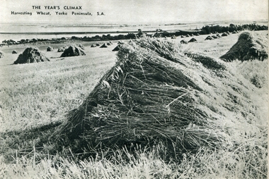
Photograph - Image - Black and White, Wheat Harvesting, Yorke Peninsula, c1950, c1950
... wheat...agriculture...Ballarat Heritage Services PO Box 2209 Bakery Hill Post Office goldfields hay yorke peninsula farming wheat agriculture A black and white image of hay stooks of wheat at Yorke Peninsula, South Australia. ...A black and white image of hay stooks of wheat at Yorke Peninsula, South Australia.hay, yorke peninsula, farming, wheat, agriculture -
 Federation University Historical Collection
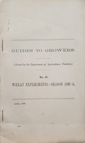
Booklet, Robt S. Brain, Guides to Growers No 37, Wheat Experiments - Season 1897-8, April 1898
... agriculture...wheat...Barker Library (top floor) Mount Helen goldfields Relates to the agriculture industry in Victoria agriculture wheat department of agriculture victoria growers guides port fairy d mcalpine Horticulture Cream paper, tables, 11pages Guides to Growers No 37, Wheat Experiments - Season 1897-8 Booklet Booklet Robt S. ...Relates to the agriculture industry in VictoriaCream paper, tables, 11pagesagriculture, wheat, department of agriculture victoria, growers guides, port fairy, d mcalpine, horticulture -
 Surrey Hills Historical Society Collection
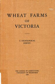
Book, Wheat farms of Victoria: a sociological survey, 1946
... wheat...social surveys...agriculture...This book goes into considerable detail on all facets of wheat farm life, providing the basis for a real understanding of the problems of the man who grows wheat. wheat social surveys agriculture (mr) alan holt farming Alan J. ...The owner, Alan Judge Holt lived locally and was Secretary of the Lands Department. Donated by Max Holt who was one of his sons. This book goes into considerable detail on all facets of wheat farm life, providing the basis for a real understanding of the problems of the man who grows wheat.Cloth-covered hardback book of 179p. Alan J. Holtwheat, social surveys, agriculture, (mr) alan holt, farming -
University of Melbourne, Burnley Campus Archives
Newspaper, Truth, By His Ears Ye Shall Know Him, 1928
... superintendent of agriculture...wheat...University of Melbourne, Burnley Campus Archives 500 Yarra Boulevard Richmond melbourne h a mullett superintendent of agriculture wheat Article in "Truth" dated 15.09.1928 about the Superintendent of Agriculture in Victoria, H. ...h a mullett, superintendent of agriculture, wheat -
 Ringwood and District Historical Society
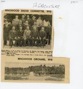
Document, Packet: Agriculture (Ringwood): Cuttings, Handwritten ""Sowing Wheat" Notes (Greg Dawson), 1909-1986
... Packet: Agriculture (Ringwood): Cuttings, Handwritten ""Sowing Wheat" Notes (Greg Dawson), 1909-1986...Agriculture; Poultry; Wheats; Dams; Mud Bricks; Ringwood Show Committee 1910 +Additional Keywords: Dawson, Greg...Greg Dawson of Merrigum aged 94, 1967, re sowing wheat, dams, mud bricks, and school. Agriculture; Poultry; Wheats; Dams; Mud Bricks; Ringwood Show Committee 1910 +Additional Keywords: Dawson, Greg Packet: Agriculture (Ringwood): Cuttings, Handwritten ""Sowing Wheat" Notes (Greg Dawson), 1909-1986 Document ...Agriculture; Poultry; Wheats; Dams; Mud Bricks; Ringwood Show Committee 1910 +Additional Keywords: Dawson, GregPacket includes: . Newspaper cutting showing Ringwood Show Committee, 1910, and Ringwood Orchard, 1910. . Letter from the Ringwood Fruit Association Limited dated 3 September, 1921 re supply of bluestone. . Hand written note on report of Ringwood Show 1909. . Extract from "The Victorian Poultry Journal" 1931 about the formation of a branch at Ringwood. . Extract from notes written by Mr. Greg Dawson of Merrigum aged 94, 1967, re sowing wheat, dams, mud bricks, and school. -
 Eltham District Historical Society Inc
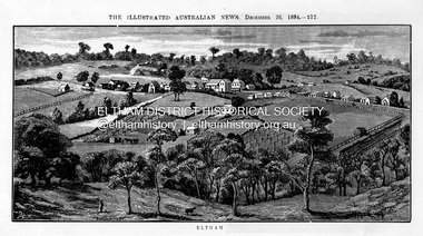
Photograph, Samuel Calvert, Eltham, The Illustrated Australian News, December 26, p212, 1884
... The land in the district is mostly used for grazing purposes, although as a rule the small farms grow a good deal of wheat, oats and other agricultural produce. A large quantity of fruit, especially raspberries and strawberries, is also produced, the rich alluvial flats along the creek upon which the township is situated being very well adapted for that purpose. ...The land in the district is mostly used for grazing purposes, although as a rule the small farms grow a good deal of wheat, oats and other agricultural produce. A large quantity of fruit, especially raspberries and strawberries, is also produced, the rich alluvial flats along the creek upon which the township is situated being very well adapted for that purpose. ...A description in the newspaper near the illustration (page 210) reads as follows: "Eltham is a pretty little township on the Yarra Flats road, about 14 miles east north east of Melbourne, from which place there is communication by way of Heidelberg. It has a population of nearly 400 inhabitants, but in addition it is the centre of a large district extending over about 203 square miles, having a population of 2344. The land in the district is mostly used for grazing purposes, although as a rule the small farms grow a good deal of wheat, oats and other agricultural produce. A large quantity of fruit, especially raspberries and strawberries, is also produced, the rich alluvial flats along the creek upon which the township is situated being very well adapted for that purpose. Gold has also been found in the vicinity of the township, but not in remunerative quantities". This photo forms part of a collection of photographs gathered by the Shire of Eltham for their centenary project book,"Pioneers and Painters: 100 years of the Shire of Eltham" by Alan Marshall (1971). The collection of over 500 images is held in partnership between Eltham District Historical Society and Yarra Plenty Regional Library (Eltham Library) and is now formally known as 'The Shire of Eltham Pioneers Photograph Collection.' It is significant in being the first community sourced collection representing the places and people of the Shire's first one hundred years.Digital imageshire of eltham pioneers photograph collection, eltham, illustrated australian news -
 Warrnambool and District Historical Society Inc.
Medal, Villiers and Heytesbury Agricultural Association (Daniel Hourigan 1877), C 1877
... W J Taylor London Reverse : Villiers & Heytesbury Agricultural Association in low relief around the edge. 1st prize awarded to Daniel Houriganfor yearling colt , "Prince of the Isles Annual Show 10th October 1877. .1 Circular silver disc with image of horse, bull, sheep, wheat sheaf and plough on the reverse with script around edge of obverse with awardees details engraved in the centre. ...This medal was awarded at the Villiers and Heytesbury Agricultural Association Annual Show to Daniel Hourigan in 1877 for his yearling colt by 'Prince of the Isles'. The formation of the Villiers and Heytesbury Agricultural Association arose out of a meeting at Woodford in 1853 and the first Show was held in Warrnambool in 1855 on a green bound by Fairy, Henna and Koroit Streets. It was held there until 1875 when it moved to the present Warrnambool Showgrounds in Koroit Street. At the 37th Annual Show in 1890 Warrnambool held its first Grand National Show, a title granted by the Chamber of Agriculture in Victoria. The Villiers and Heytesbury Agricultural Association became known as the Warrnambool Agricultural Show in 1911. Daniel Hourigan was a farmer, road contractor, poundkeeper and auditor who lived in the Tower Hill area in the 19th century. This medal is of considerable interest as it is a memento of the Villiers and Heytesbury Agricultural Association Annual Show in the 19th century. Annual Agricultural Shows have been an important feature of agricultural life in Victoria since the early days of European settlement and a feature of agricultural life in the Warrnambool district since the 1850s. The medal is also of great interest because it was awarded to Daniel Hourigan, a prominent settler in the Warrnambool district in the 19th century. .1 Circular silver disc with image of horse, bull, sheep, wheat sheaf and plough on the reverse with script around edge of obverse with awardees details engraved in the centre. Edge of the medal is plain. .2 Square maroon leather case with small metal clasp and hinge. Lined on the interior with blue velvet and cream silk.Obverse :" Warrnambool" engraved above image of cattle. W J Taylor London Reverse : Villiers & Heytesbury Agricultural Association in low relief around the edge. 1st prize awarded to Daniel Houriganfor yearling colt , "Prince of the Isles Annual Show 10th October 1877.warrnambool, villiers and heytesbury, daniel hourigan, prince of the isles, 1877, villiers & heytesbury agricultural show -
 Warrnambool and District Historical Society Inc.
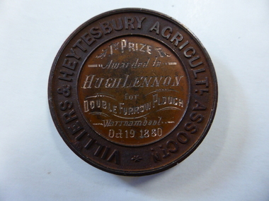
Medal - Medal VHAS, Villiers and Heytesbury Agricultural Association, Circa 1880
... Circular copper medallion cast with Villiers & Heytesbury Agricultural Assoctn around edge with winner and event details engraved in centre. The reverse is cast with horse, cow and sheep standing above wheat sheaf and farm implements. ...Circular copper medallion cast with Villiers & Heytesbury Agricultural Assoctn around edge with winner and event details engraved in centre. The reverse is cast with horse, cow and sheep standing above wheat sheaf and farm implements. ...Historical information: this medallion has historical details on three fronts. Firstly the Villiers & Heytesbury Agricultural Association. This association began with the first meeting held on May 17th 1853 at Woodford. The minutes of that meeting read “That in the opinion of this meeting, the formation of an agricultural association would be of great benefit to persons in this district engaged in farming and pastoral pursuits. It initially embraced the following: ploughing, agricultural produce, machines and implements, and livestock of all descriptions. The first show was held at Warrnambool on April 10th 1855 on a green bounded by Fairy, Henna, and Koroit Streets. It was held there until 1875 when it moved to the present Showgrounds site in Koroit Street. At the 37th Annual show in 1890 Warrnambool held its first Grand National Show, being granted by the Chamber of Agriculture in turn, in Victoria. It became known as the Warrnambool Agricultural Society in 1911. Secondly the winner, Mr Hugh Lennon. He was one of the most successful innovators and manufacturers of agricultural implements in early Australia. Although born in Ireland, he served an apprenticeship in Scotland in mechanical engineering. The Lennon plough became known Australia wide. For many years he operated his business at the northern of Elizabeth Street in Melbourne. He was active in local affairs. He died in 1886 at the age of 52. Thirdly, Stokes and Martin. Thomas Stokes came to Australia in the 1850’s and established a successful business at Mincing Lane Melbourne, manufacturing buttons, medals and tokens. Martin joined the partnership in 1873, which lasted until a disastrous fire in 1893. The business was renamed Stokes & Sons Pty Ltd and it became a public company in 1962. It is currently situated at Ringwood in the business of spare parts for electrical equipment The Villiers and Heytesbury Agricultural Association was a significant event and organisation within the Western District over a large number of years. It was one of the earliest organisations in the district and is testament to its importance to the agricultural, social, and cultural life of the district. It is significant that this particular medallion was awarded to an innovator in the ploughing industry and that it was made by a company which is still in business 130 years later. Circular copper medallion cast with Villiers & Heytesbury Agricultural Assoctn around edge with winner and event details engraved in centre. The reverse is cast with horse, cow and sheep standing above wheat sheaf and farm implements. The edge of the medallion is plain.Villiers & Heytesbury Agricultl Assoctn around rim. 1st Prize awarded to Hugh Lennon for double furrow plough, Warrnambool Oct 19 1880. Stokes & Martin Melbourne in small lettering on the reverse.warrnambool, villiers & heytesbury, hugh lennon, stokes & martin, lennon plow, lennon plough -
 Warrnambool and District Historical Society Inc.
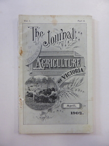
Journal, The Journal of the Department of Agriculture of Victoria April 1902, 1902
... agriculture in Victoria, including the dairying industry in the Western District. This journal is of some interest because of the photographs and information on dairying in the Western District in the early 20th century, including dairy inspection, milking controls in Koroit, prize-winning cows at Koroit and dairy bacteriology. Dairying in the Western District Koroit Dairying Warrnambool History This is a soft cover booklet of 102 pages - pages 350 to 452 of Part 4 of a journal published monthly. The back cover is missing. The front cover is black and white and has an inset of a photograph showing wheat ...This booklet has been produced in April 1902 for the Government of Victoria under the direction of the Minister for Agriculture, Hon John Morrissey M.L.A. It contains articles on agriculture in Victoria, including the dairying industry in the Western District. This journal is of some interest because of the photographs and information on dairying in the Western District in the early 20th century, including dairy inspection, milking controls in Koroit, prize-winning cows at Koroit and dairy bacteriology. This is a soft cover booklet of 102 pages - pages 350 to 452 of Part 4 of a journal published monthly. The back cover is missing. The front cover is black and white and has an inset of a photograph showing wheat harvesting. The booklet is bound with cotton thread and shows rust where the thread is tied, perhaps from metal staples now removed. The cover has a slight tear and there is some staining throughout the pages. The booklet contains maps, diagrams, sketches and black and white photographs. dairying in the western district, koroit dairying, warrnambool history -
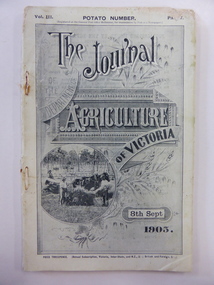 Warrnambool and District Historical Society Inc.
Journal, The Journal of the Department of Agriculture of Victoria Sept 1905, 1905
... wheat harvesting scene. The back cover is missing. The first two pages have advertisements for insurance and banking firms. The journal contains black and white photographs and statistics tables. The pages show considerable silverfish damage. The journal is bound with cotton thread and rust marks show where metal staples may have been removed. The Journal of the Department of Agriculture ...This journal has been produced in 1905 for the Government of Victoria under the direction of the Minister for Agriculture, the Hon. George Swinburne, M.L.A. It has articles on agriculture in Victoria, including an article on how to increase and improve our dairy products and an article on the Grasmere Butter Factory. This journal produced in 1905 is of considerable interest because it has an article on the inspection of the Grasmere Butter Factory and the resultant erection of a new building on the site. Dairying is a major industry in the Warrnambool area and this journal contains important historical information and photographs.This is a soft cover journal of 68 pages (pages 482 to 550 in Part 7 of a monthly publication). The front cover has a black and white photograph of a wheat harvesting scene. The back cover is missing. The first two pages have advertisements for insurance and banking firms. The journal contains black and white photographs and statistics tables. The pages show considerable silverfish damage. The journal is bound with cotton thread and rust marks show where metal staples may have been removed. grasmere butter factory, dairying in the western district, warrnambool history -
 Orbost & District Historical Society
Council Seal
... The inner section of the shield contains 4 figures, a sheaf of wheat, a factory, a co and a ship - all representing the activities of agriculture, fishing,industry and dairying undertaken in the shire. ...The inner section of the shield contains 4 figures, a sheaf of wheat, a factory, a co and a ship - all representing the activities of agriculture, fishing,industry and dairying undertaken in the shire. ...This item was used as a seal (stamp) on official Shire Council documents. The coat of arms of the Shire of Orbost was designed in the form of a cross in which five stars are depicted on a shield. A small crown above the cross indicates the loyalty of the president,councillors and ratepayers to the reigning monarch. The inner section of the shield contains 4 figures, a sheaf of wheat, a factory, a co and a ship - all representing the activities of agriculture, fishing,industry and dairying undertaken in the shire. Originally part of the Bairnsdale district, Orbost split away as part of the Tambo Shire in 1882, and became a shire in its own right as the Shire of Croajingolong on 30th May,1892. The name was changed to the Shire of Orbost on 17th February, 1893. The Orbost Shire Council was abolished on 2nd December, 1994 as part of a state-wide program of local government reform to become part of the newly constituted East Gippsland Shire council.Local governments play an important role in the lives of citizens in Australia. Local government authorities exist to provide services and amenities to local communities, and are also responsible for regulating and providing services for land and property in their district. This item is representative of a time when Orbost had its own Shire Council.The former Orbost Shire Council Seal (stamp) depicting the coat of arms. The circular seal is brass and has a wooden handle with a bulb shaped top.President, Councillors and Ratepayers of the Shire of Orbost-1892orbost orbost-shire-council government history seal -
 Orbost & District Historical Society
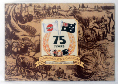
calendar, Pivot Limited, 1994
... agricultural items and scenes. "Commemorative Calendar" is in a banner above "Pivot Promotions Productivity". above the banner is a sheaf of wheat around "75 YEARS" with two flags - one the Australian flag and the other a PIVOT flag....agricultural items and scenes. "Commemorative Calendar" is in a banner above "Pivot Promotions Productivity". above the banner is a sheaf of wheat around "75 YEARS" with two flags - one the Australian flag and the other a PIVOT flag. calendar Pivot Limited ...PIVOT is a company involved in agricultural fertilisers.This is a useful pictorial reference tool.A commemorative calendar with colourful photographs, one for each month. On the front cover are brown drawings of agricultural items and scenes. "Commemorative Calendar" is in a banner above "Pivot Promotions Productivity". above the banner is a sheaf of wheat around "75 YEARS" with two flags - one the Australian flag and the other a PIVOT flag.calendar-pivot -
 Orbost & District Historical Society
plaque
... The inner circle of the shield contains four figures, a sheaf of wheat, a factory, a cow, and a ship, which represents the activities of agriculture, fishing, industry and dairying undertaken in the district. ...The inner circle of the shield contains four figures, a sheaf of wheat, a factory, a cow, and a ship, which represents the activities of agriculture, fishing, industry and dairying undertaken in the district. ...The Coat of Arms of the Shire of Orbost has been designed in the form of a cross in which five stars are set on a shield. This was typical of those used by many shires and cities throughout Victoria and the Commonwealth. A small crown above the cross indicates the loyalty of the President, Councillors and Ratepayers to the reigning King or Queen. The inner circle of the shield contains four figures, a sheaf of wheat, a factory, a cow, and a ship, which represents the activities of agriculture, fishing, industry and dairying undertaken in the district. Originally part of the Bairnsdale district, Orbost split away as part of the Shire of Tambo in 1882, and became a Shire in its own right as the Shire of Croajingolong on the 30th may 1892. The name changed to the Shire of Orbost on 17 February 1893. Orbost was divided into four ridings on 31st May 1895, they were the North, South, East and Central riding, which was represented by three elected councillors. The Shire coat of arms was on the wall on the right of the front entrance to the building and was removed from the current building when Orbost Shire Council was amalgamated into East Gippsland Shire in 1994.The current building was opened on Friday 28th February 1969 by the Premier of Victoria, The Hon. Sir Henry E. Bolte, K.C.M.G., M.P. Local governments play an important role in the lives of citizens in Australia. Local government authorities exist to provide services and amenities to local communities, and are also responsible for regulating and providing services for land and property in their district. This item is representative of a time when Orbost had its own Shire Council. A large round metal plaque with the words SHIRE OF ORBOST1892 in gold letters around a crown and shield divided into four sections to represent four industries : Shipping ; farming - maize ; dairy and mining.SHIRE OF ORBOST 1892government orbost-shire-council coat-of-arms plaque -
 Federation University Historical Collection
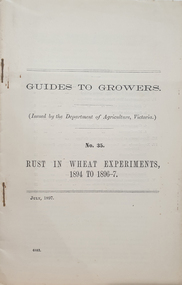
Booklet, Guides to Growers No 35, Rust in Wheat Experiments 1894 to 1896-7, July 1897
... department of agriculture, victoria...wheat...Barker Library (top floor) Mount Helen goldfields Relates to the history of the agriculture industry in Victoria agriculture department of agriculture, victoria wheat growers guides wheat rust d martin Cream paper, foldout tables, 24 pages Guides to Growers No 35, Rust in Wheat Experiments 1894 to 1896-7 Booklet Booklet ...Relates to the history of the agriculture industry in VictoriaCream paper, foldout tables, 24 pagesagriculture, department of agriculture, victoria, wheat, growers guides, wheat rust, d martin -
 Wycheproof & District Historical Society Inc.
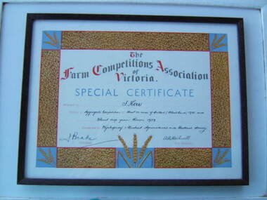
Show Certificate, Tom Kerr - Show winner, 1939 (exact)
... Framed Special Certificate issued by the Farm Competitions Associations of Victoria and awarded in 1939 by the Wycheproof & District Agricultural & Pastoral Society - Secretary A.B. Hackwell. Coloured images of wheat grains and stalks surround the printed and written words....This item relates well to key themes in the history of the region,in particular progress in agriculture and pastoral production. 1939 wycheproof show wheat crop winner "Donated by Margaret Smith nee Kerr 29. 2. 2008." ...Four families of Kerrs lived at Thalia, out of Wycheproof and when Tom's daughter Margaret donated the framed certificate she commented,"it has found a good home at the Wycheproof Historical Society."A valued Wycheproof SHOW prize for best practice agriculture in its day,year 1939. This item relates well to key themes in the history of the region,in particular progress in agriculture and pastoral production. Framed Special Certificate issued by the Farm Competitions Associations of Victoria and awarded in 1939 by the Wycheproof & District Agricultural & Pastoral Society - Secretary A.B. Hackwell. Coloured images of wheat grains and stalks surround the printed and written words."Donated by Margaret Smith nee Kerr 29. 2. 2008."1939, , wycheproof, show, wheat crop, winner -
 Eltham District Historical Society Inc
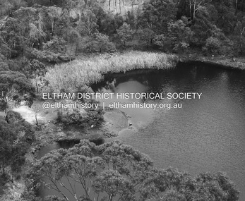
Photograph - Digital Photograph, Alan King, Blue Lake, Plenty Gorge Park, 2008
... agriculture, depleted the Wurundjeri’s traditional food sources, which helped to drive them away. Many Wurundjeri artefacts remain (now government protected), and so far 57 sites have been identified in the park, including scarred trees, burial areas and stone artefacts. Pioneer life could be very hard because of isolation, flooding, bushfires and bushrangers. Following the Black Thursday bushfires of 1851, basalt was quarried to build more fire-resistant homes. Gold discoveries in the early 1850s swelled the population, particularly around Smugglers Gully; but food production made more of an impact. In the late 1850s wheat...agriculture, depleted the Wurundjeri’s traditional food sources, which helped to drive them away. Many Wurundjeri artefacts remain (now government protected), and so far 57 sites have been identified in the park, including scarred trees, burial areas and stone artefacts. Pioneer life could be very hard because of isolation, flooding, bushfires and bushrangers. Following the Black Thursday bushfires of 1851, basalt was quarried to build more fire-resistant homes. Gold discoveries in the early 1850s swelled the population, particularly around Smugglers Gully; but food production made more of an impact. In the late 1850s wheat ...A quarry was transformed into the Blue Lake. Published: Nillumbik Now and Then / Marguerite Marshall 2008; photographs Alan King with Marguerite Marshall.; p179 The dramatic steep-sided Plenty Gorge lies along the divide of two geological areas, and separates the Nillumbik Shire and the City of Whittlesea. On the Nillumbik side are undulating hills and sedimentary rock, and in Whittlesea, lies a basalt plain formed by volcanic action up to two million years ago. This provides the Plenty Gorge Park with diverse vegetation and habitats, making it one of Greater Melbourne’s most important refuges for threatened and significant species. The park, established in 1986, consists of around 1350 hectares, and extends 11 kilometres along the Plenty River, from Greensborough to Mernda. It provides a wildlife corridor for around 500 native plant and 280 animal species. The area’s plentiful food and water attracted the Wurundjeri Aboriginal people and then European settlers. By 1837 squatters had claimed large runs of land for their sheep and cattle. The Plenty Valley was among the first in the Port Phillip District to be settled - mainly in the less heavily timbered west - and was proclaimed a settled district in 1841.But by the late 1880s, the settlers’ extensive land clearing for animal grazing, then agriculture, depleted the Wurundjeri’s traditional food sources, which helped to drive them away. Many Wurundjeri artefacts remain (now government protected), and so far 57 sites have been identified in the park, including scarred trees, burial areas and stone artefacts. Pioneer life could be very hard because of isolation, flooding, bushfires and bushrangers. Following the Black Thursday bushfires of 1851, basalt was quarried to build more fire-resistant homes. Gold discoveries in the early 1850s swelled the population, particularly around Smugglers Gully; but food production made more of an impact. In the late 1850s wheat production supplanted grazing. In the 1860s the government made small holdings available to poorer settlers. These had the greatest effect on the district, particularly in Doreen and Yarrambat, where orchards were established from the 1880s to 1914. Links with a prominent early family are the remains of Stuchbery Farm, by the river’s edge bounded by Smugglers Gully to the north and La Trobe Road, Yarrambat, to the east. The Stuchberys moved to the valley in 1890, and the family still lives in the area. In 1890, Alfred and Ada first lived in a tent where four children were born, then Alfred built the house and outbuildings around 1896. They planted an orchard, then a market garden, and developed a dairy. The family belonged to the local Methodist and tennis communities. Their grandson Walter, opened the Flying Scotsman Model Railway Museum in Yarrambat, which his widow, Vi, continues to run. Wal was also the Yarrambat CFA Captain for 22 years until 1987. Walter sold 24 hectares in 1976 for development - now Vista Court - and in 1990, the remaining 22.6 hectares for the park. Remaining are an early stone dairy and remnants of a stone barn, a pig sty and a well. Until it was destroyed by fire in 2003, a slab hut stood on the Happy Hollow Farm site, at the southern end of the park. The hut is thought to have been built in the Depression around 1893. This was a rare and late example of a slab hut with a domestic orchard close to Melbourne. Emmet Watmough and his family first occupied the hut, followed by a succession of families, until the Bell family bought it around 1948. There they led a subsistence lifestyle for 50 years, despite encroaching Melbourne suburbia. The Yellow Gum Recreation Area includes the Blue Lake, coloured turquoise at certain times of the year. Following the 1957 bushfires, this area was quarried by Reid Quarries Pty Ltd for Melbourne’s first skyscrapers, then by Boral Australia. However in the early 1970s water began seeping into the quarry forming the Blue Lake and the quarry was closed. The State Government bought the site in 1997 and opened it as a park in 1999.This collection of almost 130 photos about places and people within the Shire of Nillumbik, an urban and rural municipality in Melbourne's north, contributes to an understanding of the history of the Shire. Published in 2008 immediately prior to the Black Saturday bushfires of February 7, 2009, it documents sites that were impacted, and in some cases destroyed by the fires. It includes photographs taken especially for the publication, creating a unique time capsule representing the Shire in the early 21st century. It remains the most recent comprehenesive publication devoted to the Shire's history connecting local residents to the past. nillumbik now and then (marshall-king) collection, blue lake, plenty gorge park -
 Eltham District Historical Society Inc
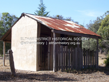
Photograph - Digital Photograph, Marguerite Marshall, Stuchbery Farm dairy, 14 March 2008
... agriculture, depleted the Wurundjeri’s traditional food sources, which helped to drive them away. Many Wurundjeri artefacts remain (now government protected), and so far 57 sites have been identified in the park, including scarred trees, burial areas and stone artefacts. Pioneer life could be very hard because of isolation, flooding, bushfires and bushrangers. Following the Black Thursday bushfires of 1851, basalt was quarried to build more fire-resistant homes. Gold discoveries in the early 1850s swelled the population, particularly around Smugglers Gully; but food production made more of an impact. In the late 1850s wheat...agriculture, depleted the Wurundjeri’s traditional food sources, which helped to drive them away. Many Wurundjeri artefacts remain (now government protected), and so far 57 sites have been identified in the park, including scarred trees, burial areas and stone artefacts. Pioneer life could be very hard because of isolation, flooding, bushfires and bushrangers. Following the Black Thursday bushfires of 1851, basalt was quarried to build more fire-resistant homes. Gold discoveries in the early 1850s swelled the population, particularly around Smugglers Gully; but food production made more of an impact. In the late 1850s wheat ...Stuchbery Farm was situated on the Plenty River bounded by Smugglers Gully to the north and La trobe Road, Yarrambat, to the east. Alan and Ada Stutchbery moved to the valley in 1890, first living in a tent where four children were born. Alfred built a home and outbuildings around 1896. They planted an orchard, then a market garden and developed a dairy. Published: Nillumbik Now and Then / Marguerite Marshall 2008; photographs Alan King with Marguerite Marshall.; p179 The dramatic steep-sided Plenty Gorge lies along the divide of two geological areas, and separates the Nillumbik Shire and the City of Whittlesea. On the Nillumbik side are undulating hills and sedimentary rock, and in Whittlesea, lies a basalt plain formed by volcanic action up to two million years ago. This provides the Plenty Gorge Park with diverse vegetation and habitats, making it one of Greater Melbourne’s most important refuges for threatened and significant species. The park, established in 1986, consists of around 1350 hectares, and extends 11 kilometres along the Plenty River, from Greensborough to Mernda. It provides a wildlife corridor for around 500 native plant and 280 animal species. The area’s plentiful food and water attracted the Wurundjeri Aboriginal people and then European settlers. By 1837 squatters had claimed large runs of land for their sheep and cattle. The Plenty Valley was among the first in the Port Phillip District to be settled - mainly in the less heavily timbered west - and was proclaimed a settled district in 1841. But by the late 1880s, the settlers’ extensive land clearing for animal grazing, then agriculture, depleted the Wurundjeri’s traditional food sources, which helped to drive them away. Many Wurundjeri artefacts remain (now government protected), and so far 57 sites have been identified in the park, including scarred trees, burial areas and stone artefacts. Pioneer life could be very hard because of isolation, flooding, bushfires and bushrangers. Following the Black Thursday bushfires of 1851, basalt was quarried to build more fire-resistant homes. Gold discoveries in the early 1850s swelled the population, particularly around Smugglers Gully; but food production made more of an impact. In the late 1850s wheat production supplanted grazing. In the 1860s the government made small holdings available to poorer settlers. These had the greatest effect on the district, particularly in Doreen and Yarrambat, where orchards were established from the 1880s to 1914. Links with a prominent early family are the remains of Stuchbery Farm, by the river’s edge bounded by Smugglers Gully to the north and La Trobe Road, Yarrambat, to the east. The Stuchberys moved to the valley in 1890, and the family still lives in the area. In 1890, Alfred and Ada first lived in a tent where four children were born, then Alfred built the house and outbuildings around 1896. They planted an orchard, then a market garden, and developed a dairy. The family belonged to the local Methodist and tennis communities. Their grandson Walter, opened the Flying Scotsman Model Railway Museum in Yarrambat, which his widow, Vi, continues to run. Wal was also the Yarrambat CFA Captain for 22 years until 1987. Walter sold 24 hectares in 1976 for development - now Vista Court - and in 1990, the remaining 22.6 hectares for the park. Remaining are an early stone dairy and remnants of a stone barn, a pig sty and a well. Until it was destroyed by fire in 2003, a slab hut stood on the Happy Hollow Farm site, at the southern end of the park. The hut is thought to have been built in the Depression around 1893. This was a rare and late example of a slab hut with a domestic orchard close to Melbourne. Emmet Watmough and his family first occupied the hut, followed by a succession of families, until the Bell family bought it around 1948. There they led a subsistence lifestyle for 50 years, despite encroaching Melbourne suburbia. The Yellow Gum Recreation Area includes the Blue Lake, coloured turquoise at certain times of the year. Following the 1957 bushfires, this area was quarried by Reid Quarries Pty Ltd for Melbourne’s first skyscrapers, then by Boral Australia. However in the early 1970s water began seeping into the quarry forming the Blue Lake and the quarry was closed. The State Government bought the site in 1997 and opened it as a park in 1999.This collection of almost 130 photos about places and people within the Shire of Nillumbik, an urban and rural municipality in Melbourne's north, contributes to an understanding of the history of the Shire. Published in 2008 immediately prior to the Black Saturday bushfires of February 7, 2009, it documents sites that were impacted, and in some cases destroyed by the fires. It includes photographs taken especially for the publication, creating a unique time capsule representing the Shire in the early 21st century. It remains the most recent comprehenesive publication devoted to the Shire's history connecting local residents to the past. nillumbik now and then (marshall-king) collection, ada stuchbery, alan stuchbery, dairy, stuchbery farm, farm buildings, yarrambat, plenty gorge park -
 Bendigo Historical Society Inc.
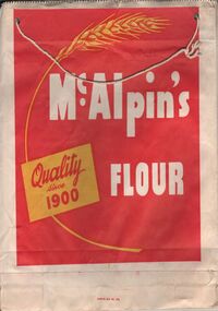
Ephemera - SHOWBAGS COLLECTION: MCALPIN'S FLOUR BAG SHOWBAG
... agricultural shows and other promotional activities. A paper bag. The design is in red, yellow and white. the words McAlpin's flour, quality since 1900. The picture of a wheat ...A paper bag. The design is in red, yellow and white. the words McAlpin's flour, quality since 1900. The picture of a wheat sheaf is on the right hand side. The same design on both sides of the bag.business, retail, advertising, business advertising usually found at agricultural shows and other promotional activities. -
 Bendigo Historical Society Inc.
Slide - Mouat Crawford Collection: Farming Life in the Wimmera
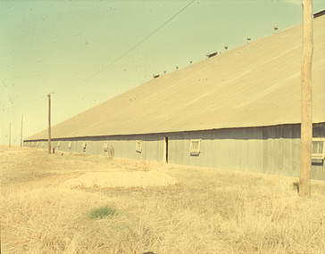
... AGRICULTURE...Farm...Crop Storage...wimmera...wheat...History House 11 Mackenzie Street Bendigo goldfields AGRICULTURE Farm Crop Storage wimmera wheat silo stick shed murtoa mouat crawford collection PERUTZ Wheat terminal at Murtoa, known as the stick shed Markings: Murtoa(SIC) Bulk Wheat Terminal. ...Wheat terminal at Murtoa, known as the stick shed Markings: Murtoa(SIC) Bulk Wheat Terminal. The Stick Shed. Used as a teaching aid.PERUTZagriculture, farm, crop storage, wimmera, wheat silo, stick shed, murtoa, mouat crawford collection -
 Bendigo Historical Society Inc.
Slide - Mouat Crawford Collection: Farming Life in the Wimmera, c1960s
... AGRICULTURE...Farm...Crop...wheat...History House 11 Mackenzie Street Bendigo goldfields AGRICULTURE Farm Crop wheat wimmera sheaves mouat crawford collection ILFORD Cutting the crop ready to make sheaths. ...Cutting the crop ready to make sheaths. Used as a teaching aid.ILFORDagriculture, farm, crop, wheat, wimmera, sheaves, mouat crawford collection -
 Bendigo Historical Society Inc.
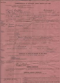
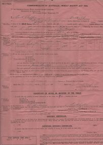
Document - ERROL BOVAIRD COLLECTION: WHEAT BOUNTY CLAIM
... AGRICULTURE...Farm...Wheat...History House 11 Mackenzie Street Bendigo goldfields AGRICULTURE Farm Wheat crop The John Bovaird Collection : Commonwealth of Australia Wheat Bounty Act 1934 State of Victoria Claim for Payment. ...The John Bovaird Collection : Commonwealth of Australia Wheat Bounty Act 1934 State of Victoria Claim for Payment. By Errol Balfour Bovaird of May Reef PO via Avonmore. Regarding 150 bushels delivered for sale to John T Stewart of Lockington. Wheat produced on 50 acres : Allotment 25 Parish of Pannoo Bamawm. Dated 13/4/1935. Pink paper.agriculture, farm, wheat crop -
 Bendigo Historical Society Inc.
Slide - Mouat Crawford Collection: Farming Life in the Wimmera, c1960s
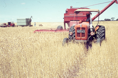
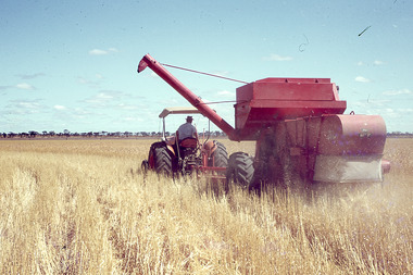
... AGRICULTURE...Farm...Wheat...History House 11 Mackenzie Street Bendigo goldfields AGRICULTURE Farm Wheat crop tractor header harvester wimmera mouat crawford collelction Agfacolor Tractor pulling a Massey Ferguson header, field bin, truck and station wagon in background, also a lady. ...Tractor pulling a Massey Ferguson header, field bin, truck and station wagon in background, also a lady. Markings:White tape on bottom of slide reads; Wheat header working. Used as a teaching aid.Agfacoloragriculture, farm, wheat crop, tractor, header, harvester, wimmera, mouat crawford collelction -
 Bendigo Historical Society Inc.
Slide - Mouat Crawford Collection: Farming Life in the Wimmera, c1960s
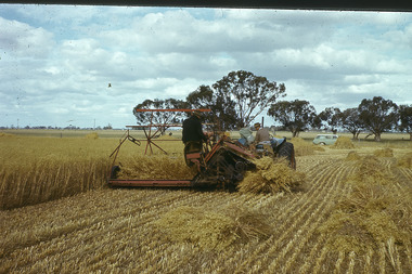
... AGRICULTURE...Farm...Wheat...History House 11 Mackenzie Street Bendigo goldfields AGRICULTURE Farm Wheat crop harvesting header tractor mouat crawfored collection Agfacolor Harvesting wheat crop is written on white tape on bottom of slide. ...Harvesting wheat crop is written on white tape on bottom of slide. Used as a teaching aid.Agfacoloragriculture, farm, wheat crop, harvesting header, tractor, mouat crawfored collection -
 Bendigo Historical Society Inc.
Slide - Mouat Crawford Collection: Farming Life in the Wimmera, c1960s
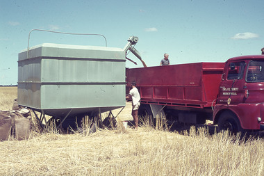
... AGRICULTURE...Farm...Crop...warracknabeal...wimmera...truck wheat...History House 11 Mackenzie Street Bendigo goldfields AGRICULTURE Farm Crop warracknabeal wimmera truck wheat hewitt mouat crawford collection Agfacolor Filling the truck with wheat from the field bin. ...Filling the truck with wheat from the field bin. Name on door of truck is D W L V Hewitt, Warracknabeal. A man in the back of the truck and one standing on the ground at the controls of the field bin. Markings: Wheat - farm bulk field bin to truck. Used as a teaching aid.Agfacoloragriculture, farm, crop, warracknabeal, wimmera, truck wheat, hewitt, mouat crawford collection -
 Bendigo Historical Society Inc.
Slide - Mouat Crawford Collection: Farming Life in the Wimmera, c1960s
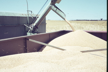
... AGRICULTURE...Farm...Crop...wimmera...wheat...History House 11 Mackenzie Street Bendigo goldfields AGRICULTURE Farm Crop wimmera wheat truck mouat crawford collection Agfacolor Shows wheat from the field bin being transferred into the back of the truck for cartage. ...Shows wheat from the field bin being transferred into the back of the truck for cartage. Markings: Wheat from field bin into truck. Used as a teaching aid.Agfacoloragriculture, farm, crop, wimmera, wheat truck, mouat crawford collection -
Bendigo Historical Society Inc.
Slide - MOUAT CRAWFORD COLLECTION - FARMING IN THE WIMMERA, c1960s
... History House 11 Mackenzie Street Bendigo goldfields AGRICULTURE Farm Crop ILFORD MOUAT CRAWFORD COLLECTION - Farming in the Wimmera. Baled Hay sitting in from of the remainder of un cropped crop. Markings: Wheat ...MOUAT CRAWFORD COLLECTION - Farming in the Wimmera. Baled Hay sitting in from of the remainder of un cropped crop. Markings: Wheat Crop with Baled hay.ILFORDagriculture, farm, crop -
 Bendigo Historical Society Inc.
Slide - Mouat Crawford Collection: Farming Life in the Wimmera, c1960s
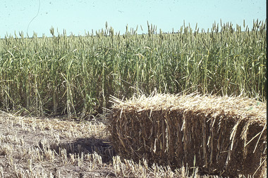
... AGRICULTURE...Farm...Crop...wimmera...baled wheat...History House 11 Mackenzie Street Bendigo goldfields AGRICULTURE Farm Crop wimmera baled wheat mouat crawford collection Agfacolor Baled Hay sitting in from of the remainder of un cropped crop. ...Baled Hay sitting in from of the remainder of un cropped crop. Markings: Wheat Crop with Baled hay. Used as a teaching aid.Agfacoloragriculture, farm, crop, wimmera, baled wheat, mouat crawford collection -
 Bendigo Historical Society Inc.
Document - ERROL BOVAIRD COLLECTION: WHEAT BOUNTY CLAIM
... AGRICULTURE...Farm...Wheat...History House 11 Mackenzie Street Bendigo goldfields AGRICULTURE Farm Wheat crop The John Bovaird Collection. ...The John Bovaird Collection. Commonwealth of Australia Wheat Bounty Act 1934 State of Victoria Claim for Payment. By Errol Balfour Bovaird of May Reef PO via Avonmore. Regarding 96 bushels delivered for sale to R. Anderson of Lockington. Wheat produced on 50 acres : Allotment 25 Parish of Pannoo Bamawm. Dated 13/4/1935. Pink paper.agriculture, farm, wheat crop