Showing 6 items matching "wind drift"
-
 Frankston RSL Sub Branch
Calculator, Course & Speed, E.R Watts & Son London Pty Ltd
... ...wind drift...Frankston RSL Sub Branch 183 Cranbourne Road Frankston mornington-peninsula raaf navigation calculator ww2 raf aircraft course speed wind drift Inscribed "COURSE & SPEED CALCULATOR MKII", "E.R.WATTS & Son No 757/35", "A.M. ...Course and Speed calculator used as a navigational aid by Air Force pilots to calculate aircraft relative groundspeed whilst allowing for wind speed and direction. A similar example (MKIIA version) can be seen at the following Imperial War Museum web page: Inscribed "COURSE & SPEED CALCULATOR MKII", "E.R.WATTS & Son No 757/35", "A.M. REF No 6B/119".raaf, navigation, calculator, ww2, raf, aircraft, course, speed, wind drift -
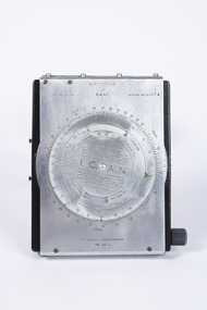 Nhill Aviation Heritage Centre
Navigation Computer
... This type of instrument typically used by pilots and navigators for quick calculations of Air Speed and Wind Drift....Nhill Aviation Heritage Centre 1 Aerodrome Road Nhill grampians This type of instrument typically used by pilots and navigators for quick calculations of Air Speed and Wind Drift. Indent No. G6B/145 RAAF Serial No. ...This type of instrument typically used by pilots and navigators for quick calculations of Air Speed and Wind Drift.hand operated navigation computer. Rotating scale on the front panel and a scroll type scale on the inner panel with a winder knob on the right side. Front panel is hinged at the top and bottom has two curved thigh pads.Indent No. G6B/145 RAAF Serial No. WG/2967* I.C.A.N. in center of front dial COMPUTER NAVIGATIONAL Ml. III D. -
Frankston RSL Sub Branch
Drift Recorder, W & G, A M Drift Recorder MKII, 1930 - 1939
... drift of aircraft when operating in crosswind conditions. This device has an eyepiece and a prismatic periscope for viewing a distant feature being tracked. This device has calibrated rotary scales for height, speed (in KNOTS and MPH), and an adjustment to preset the 'crab angle' of the aircaft for cross wind compensation. ...drift of aircraft when operating in crosswind conditions. This device has an eyepiece and a prismatic periscope for viewing a distant feature being tracked. This device has calibrated rotary scales for height, speed (in KNOTS and MPH), and an adjustment to preset the 'crab angle' of the aircaft for cross wind compensation. ...Purpose built mechanical calculation machine for determining the drift of aircraft when operating in crosswind conditions. This device has an eyepiece and a prismatic periscope for viewing a distant feature being tracked. This device has calibrated rotary scales for height, speed (in KNOTS and MPH), and an adjustment to preset the 'crab angle' of the aircaft for cross wind compensation. The device can be opened for cleaning or maintenance purposes. Refer to the following extracts for information about bomb drift: "Crosswinds brought into the bombing problem a new factor, "drift" In order to fly a given ground track in a crosswind, an aircraft had to "crab" into the wind; the angle formed between the aircraft's true heading and its ground track was called the "drift angle" In a crosswind, the bomb would impact directly behind the aircraft and along its longitudinal axis at the moment of release. But this meant that the bomb would strike the ground at some point downwind of the aircraft's ground track. Thus, in order to score a hit, the bomber had to fly a ground track that ran upwind of the target." "Air resistance acting on a bomb after release caused it to lag behind the drop point and hit somewhere behind the bomber. The distance from a point beneath the aircraft at the instant of bomb impact to the point of bomb impact was called "trail." Trail increased as the bomber's airspeed increased or as its altitude increased. Furthermore, since different bombs encountered different resistance in the air, trail was also a factor of bomb shape."A. M. Drift Recorder MKII REF. No 6B/190 No 2668/41 X/ 3606 3E4H28 -
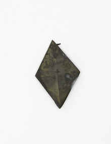 Queenscliffe Maritime Museum
Clothing - Belt decoration
... When the wind suddenly dropped the ship drifted onto an uncharted reef and became stuck fast. ...When the wind suddenly dropped the ship drifted onto an uncharted reef and became stuck fast. ...She was nearing the end of her voyage, close inshore off Cape Otway at Curdies Inlet (now called Schomberg Reef), east of Peterborough and 150 miles westward of Melbourne. When the wind suddenly dropped the ship drifted onto an uncharted reef and became stuck fast. There was no loss of life ans all the passengers, crew and mails were taken off by a passing coastal steamer, the Queen, out of Port Fairy the following morning. The passengers' luggage and some of the cargo was rescued, but the weather worsened and work was abandoned and cargo littered the beach. The wreck was sold for salvage to local merchants: two were drowned in attempts to reach her. It became a popular wreck site for diving and over 100 relics have been handed in. The bell of the ship is in the Warrnambool Museum, southern Victoria. Relics at Flagstaff Hill Maritime Museum include a cannon, a communion set, a brass candlestick, and a diamond ring.A diamond shaped brass belt decorationschomberg, salvage, peterborough -
Moorabbin Air Museum
Book - Aerial navigation, Practical Air Navigation
... wind...Velocities...Dead reckoning...Course & distance calculator...Drift...Moorabbin Air Museum Moorabbin Airport 12 First Street Moorabbin melbourne Aerial navigation Bearings & courses Effect of wind Velocities Dead reckoning Course & distance calculator Drift Direction finding wireless Cross bearings Attempt to provide overview of aerial navigation in simple terms, circa 1940 Practical Air Navigation Book Aerial navigation ...Attempt to provide overview of aerial navigation in simple terms, circa 1940non-fictionAttempt to provide overview of aerial navigation in simple terms, circa 1940bearings & courses, effect of wind, velocities, dead reckoning, course & distance calculator, drift, direction finding wireless, cross bearings -
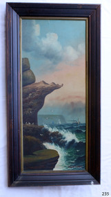 Flagstaff Hill Maritime Museum and Village
Painting - Oil painting, W. Langley-Taylor, Eagle Rock, Warrnambool, Vic, Late 19th to early 20th century
... In the painting, the breaking waves and northerly drift of smoke from the steamship suggest a strong southerly wind. THE INSCRIPTIONS “Mrs M Irby” and “980/Regency”:- The significance of the inscription “Mrs M Irby”, which appears on the reverse of both paintings, has not been determined. ...In the painting, the breaking waves and northerly drift of smoke from the steamship suggest a strong southerly wind. THE INSCRIPTIONS “Mrs M Irby” and “980/Regency”:- The significance of the inscription “Mrs M Irby”, which appears on the reverse of both paintings, has not been determined. ...This painting is one of a pair of large works by W. Langley-Taylor in our collection. Further information about the artist has not yet been identified. The pair depicts coastal sites on either side of Port Phillip Bay, south of Melbourne. This work represents Eagle Rock, Warrnambool, on the bay’s western side. Eagle Rock lies about 400 metres west of Thunder Point, near Shelly Beach. The painting shows the cliff formations looking east towards the Warrnambool Breakwater. The site is well known locally, appears in many photographs, and is also a recognised dive location in calm conditions. This stretch of Warrnambool coastline is exposed to the Southern Ocean. In the painting, the breaking waves and northerly drift of smoke from the steamship suggest a strong southerly wind. THE INSCRIPTIONS “Mrs M Irby” and “980/Regency”:- The significance of the inscription “Mrs M Irby”, which appears on the reverse of both paintings, has not been determined. It may refer to the ship or shipping company Irby. Irby was a four-masted iron ship built in Liverpool in 1881. It later traded between London and Australia, including visits to Melbourne and Hobart, before being destroyed by a mine in 1919 while en route to England. Alternatively, “Mrs M Irby” and the pencil inscription “980/Regency” may refer to a delivery address, perhaps an apartment or hotel. This painting is geographically significant for its depiction of Victoria’s coastal scenery. It is also significant as one of a pair of seascapes depicting sites on either side of Port Phillip Bay. Historically, the painting is significant as an example of the late nineteenth- and early twentieth-century methods and materials used in frame construction.Painting oil on board in a dark wooden frame, portrait orientation. Seascape of rock formation and cliffs, two yachts, a two-masted steamboat with red funnel and smoke, flying birds, high waves breaking onto rocks, blue sky with clouds, some tinted pink. The title is painted on the lower left corner, and the artist, W. Langley-Taylor, has signed his name on the lower right. The inscription on the back is handwritten script in red crayon or thick red pencil. The board is held in place inside the timber frame with small, dark metal tacks around all sides. Metal eyes join the wire to the frame. Small, round, dark metal nail heads are dispersed around the frame, and there is a change of colour on both the board and the wood of the frame. Painted on front “W.LANGLEY-TAYLOR.” and “EAGLE ROCK, WARRNAMBOOL, VIC.” Handwritten on back “Mrs. M. Irby” and “980 [underlined] Regency”flagstaff hill, warrnambool, shipwrecked coast, flagstaff hill maritime museum, maritime museum, shipwreck coast, flagstaff hill maritime village, great ocean road, eagle rock warrnambool, w. langley-taylor, oil painting, wall decoration, seascape of victoria's coast, mrs m irby, art, seascape, pair of paintings