Showing 261 items matching "wood's point road"
-
 Marysville & District Historical Society
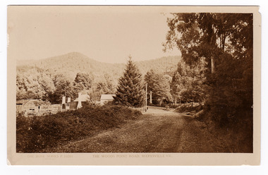
Postcard (item) - Black and white postcard, Rose Stereograph Company, The Wood's Point Road, Marysville, Vic, 1913-1967
... The Wood's Point Road, Marysville, Vic....wood's point road...A black and white photograph of the Wood's Point Road in Marysville, Victoria. Rose Series postcards P. 10201....A black and white photograph of the Wood's Point Road in Marysville , Victoria. This is now known as the Marysville-Wood's Point Road. ...A postcard in a series produced by the Rose Stereograph Company in Victoria, Australia as a souvenir of Marysville.A black and white photograph of the Wood's Point Road in Marysville , Victoria. This is now known as the Marysville-Wood's Point Road. The Marysville-Woods Point Road was originally part of the Yarra Track, constructed in the early 1860s to provide access between Healesville and the Woods Point Goldfields. Despite the steep terrain and engineering difficulties, the Yarra Track soon became a busy route used by pack horses, horse-drawn drays, and wagons. Today this sealed mountain road is a popular scenic drive between Marysville and Warburton.POST CARD REAL PHOTO THE "ROSE" SERIES DE LUXE PRODUCED IN AUSTRALIA Published by "The Rose Stereographer"/ Sydney and Melbourne.wood's point road, marysville-wood's point road, marysville, victoria, p. 10201, rose series postcard, postcard, souvenir, yarra track, mining, wood's point, warburton -
 Marysville & District Historical Society
Document (item) - Research document, Judith Vimpani, 22 Woods Point Road, 09-2022
... ...wood's point road...A research document outlining the history of the various guest houses that were built on the site at 22 Wood's Point Road in Marysville....A research document outlining the history of the various guest houses that were built on the site at 22 Wood's Point Road in Marysville....22 Wood's Point Road, Marysville, North Central, Victoria, Australia...Marysville & District Historical Society 39 Darwin Street Marysville yarra-valley-and-the-dandenong-ranges A research document outlining the history of the various guest houses that were built on the site at 22 Wood's Point Road in Marysville. A research document outlining the history of the various guest houses that were built on the site at 22 Wood's Point Road in Marysville. marysville victoria australia kerami guesthouse sister elizabeth glover wood's point road kerami house pack road murchison street marysville & district tourist & progress association sister helena brayshay marion bethia curdie sister margaret vincent thomas sister elsie rose beatrice bolam mbe lesley archibald elinor macgowan mary lodge silver birch motel kufstein inn the birches kerami gardens resort A research document outlining the history of the various guest houses that were built on the site at 22 Wood's Point Road in Marysville. 22 Woods Point Road Document Research document Judith Vimpani ...A research document outlining the history of the various guest houses that were built on the site at 22 Wood's Point Road in Marysville.A research document outlining the history of the various guest houses that were built on the site at 22 Wood's Point Road in Marysville.marysville, victoria, australia, kerami guesthouse, sister elizabeth glover, wood's point road, kerami house, pack road, murchison street, marysville & district tourist & progress association, sister helena brayshay, marion bethia curdie, sister margaret vincent thomas, sister elsie rose beatrice bolam mbe, lesley archibald elinor macgowan, mary lodge, silver birch motel, kufstein inn, the birches, kerami gardens resort -
 Marysville & District Historical Society
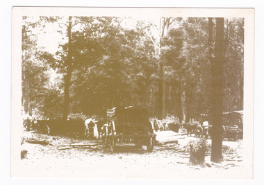
Postcard (item) - Black and white postcard, Marysville & District Historical Society Inc, Bullock Teams at the Dump, Woods Point Road, 1993
... ...marysville-wood's point road...A black and white photograph of bullock teams at the Log Dump at on the Wood's Point Road....A black and white photograph of bullock teams at the Log Dump at on the Wood's Point Road....YESTERYEAR POSTCARDS AFFIX/ STAMP/ HERE BULLOCK TEAMS AT THE DUMP,/ WOODS POINT ROAD. C Marysville Historical Society, 1993...The Marysville-Woods Point Road was originally part of the Yarra Track, constructed in the early 1860s to provide access between Healesville and the Woods Point Goldfields. ...A black and white photograph of bullock teams at the Log Dump at on the Wood's Point Road.A black and white photograph of bullock teams at the Dump at on the Wood's Point Road. The Marysville-Woods Point Road was originally part of the Yarra Track, constructed in the early 1860s to provide access between Healesville and the Woods Point Goldfields. Despite the steep terrain and engineering difficulties, the Yarra Track soon became a busy route used by pack horses, horse-drawn drays, and wagons. Today this sealed mountain road is a popular scenic drive between Marysville and Warburton. This postcard was produced by the Marysville Historical Society as a souvenir of Marysville.YESTERYEAR POSTCARDS AFFIX/ STAMP/ HERE BULLOCK TEAMS AT THE DUMP,/ WOODS POINT ROAD. C Marysville Historical Society, 1993marysville, bullock teams, woods point road, victoria, marysville historical society, postcard, souvenir, yesteryear postcards, marysville-wood's point road, yarra track, healesville, mining, timber mills, warburton -
Marysville & District Historical Society
Document (item) - Research document, Judith Vimpani, Mary Lodge, 2023
... ...wood's point road...Mary Lodge was positioned further along the Wood's Point Road from the original Kerami Guesthouse....Mary Lodge was positioned further along the Wood's Point Road from the original Kerami Guesthouse....Wood's Point Road, Marysville, North Central, Victoria, Australia...Mary Lodge was positioned further along the Wood's Point Road from the original Kerami Guesthouse. ...A document outlining the history of Mary Lodge in Marysville. Mary Lodge replaced the original Kerami Guesthouse which was built in 1907 for Sister Elizabeth Glover. For 25 years Kerami Guesthouse was operated by nursing sisters. Mary Lodge was positioned further along the Wood's Point Road from the original Kerami Guesthouse.A document outlining the history of Mary Lodge in Marysville. Mary Lodge replaced the original Kerami Guesthouse which was built in 1907 for Sister Elizabeth Glover. For 25 years Kerami Guesthouse was operated by nursing sisters. Mary Lodge was positioned further along the Wood's Point Road from the original Kerami Guesthouse.marysville, victoria, australia, kerami guesthouse, sister elizabeth glover, wood's point road, kerami house, pack road, murchison street, marysville & district tourist & progress association, sister helena brayshay, marion bethia curdie, sister margaret vincent thomas, sister elsie rose beatrice bolam mbe, lesley archibald elinor macgowan, mary lodge, document, mary guesthouse chain, marylands, mary lyn, mary meadows, eric dowdle, j.e. dowdle, jim walker, madge walker, g.h. brett -
Marysville & District Historical Society
Document (Item) - Newspaper article, The Argus, New Tourist Road. Marysville to Wood's Point Magnificent Forest Scenery, 02-1924
... marysville-wood's point road...A newspaper article regarding the opening of the Marysville-Wood's Point Road in February 1924....A newspaper article regarding the opening of the Marysville-Wood's Point Road in February 1924....The Marysville-Woods Point Road was originally part of the Yarra Track, constructed in the early 1860s to provide access between Healesville and the Woods Point Goldfields. ...A newspaper article regarding the opening of the Marysville-Wood's Point Road in February 1924.A newspaper article regarding the opening of the Marysville-Wood's Point Road in February 1924. The Marysville-Woods Point Road was originally part of the Yarra Track, constructed in the early 1860s to provide access between Healesville and the Woods Point Goldfields. Despite the steep terrain and engineering difficulties, the Yarra Track soon became a busy route used by pack horses, horse-drawn drays, and wagons. Today this sealed mountain road is a popular scenic drive between Marysville and Warburton.marysville-wood's point road, yarra track, healesville, wood's point goldfields, warburton, the argus -
 Marysville & District Historical Society
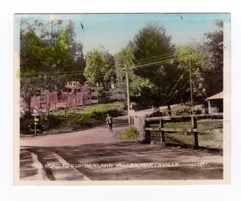
Photograph (item) - Colour tinted photograph, Valentine Publishing Co. Pty. Ltd, The Road to Cumberland Valley, Marysville. No. 1, 1923-1963
... ...wood's point road...An early colour tinted photograph of the intersection of the Buxton Marysville Road and the Marysville-Wood's Point Road....An early colour tinted photograph of the intersection of the Buxton Marysville Road and the Marysville-Wood's Point Road. In the right of the photograph The Crossways Hotel can just be seen. ...Marysville & District Historical Society 39 Darwin Street Marysville yarra-valley-and-the-dandenong-ranges An early colour tinted photograph of the intersection of the Buxton Marysville Road and the Marysville-Wood's Point Road. An early photograph of the Buxton Marysville Road and the Marysville-Wood's Point Road intersection. ...An early colour tinted photograph of the intersection of the Buxton Marysville Road and the Marysville-Wood's Point Road.An early photograph of the Buxton Marysville Road and the Marysville-Wood's Point Road intersection. The Marysville-Buxton Road joins the Maroondah Highway which leads to Alexandra. The Marysville-Woods Point Road was originally part of the Yarra Track, constructed in the early 1860s to provide access between Healesville and the Woods Point Goldfields. Despite the steep terrain and engineering difficulties, the Yarra Track soon became a busy route used by pack horses, horse-drawn drays, and wagons. Today this sealed mountain road is a popular scenic drive between Marysville and Warburton. On the right of the photograph can be seen 'The Crossways Hotel' which is circa 1920 and one of the oldest buildings still standing in Marysville. 'The Crossways Hotel' survived the 2009 Black Saturday bushfires, through the efforts of the owner using buckets of water from the nearby Steavenson River. In the background can be seen the Poontawan Guest House which later became the Marysville Chalet Guest House which was on the site of the original Steavenson's Hotel. That guest house no longer exists and the Christ Church stands on the land where the guest house once stood. This photograph was published by the Valentine Publishing Co Pty. Ltd as a souvenir of Marysville.marysville, victoria, marysville chalet guest house, crossways hotel, christ church marysville, poontawan guest house, steavenson's hotel, valentine publishing co, souvenir, yarra track, wood's point road, mining, buxton-marysville road, marysville-wood's point road, maroondah highway, alexandra -
 Marysville & District Historical Society
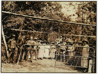
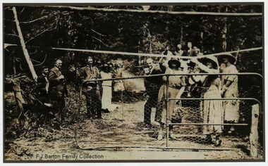
Photograph (Item) - Black and white photograph, 05-02-1924
... marysville-wood's point road...An early black and white photograph of the ceremonial re-opening of the Marysville-Wood's Point Road in 1924....An early black and white photograph of the ceremonial re-opening of the Marysville-Wood's Point Road in 1924....The Marysville-Woods Point Road was originally part of the Yarra Track, constructed in the early 1860s to provide access between Healesville and the Woods Point Goldfields. ...An early black and white photograph of the ceremonial re-opening of the Marysville-Wood's Point Road in 1924.An early black and white photograph of the ceremonial re-opening of the Marysville-Wood's Point Road in 1924. The Marysville-Woods Point Road was originally part of the Yarra Track, constructed in the early 1860s to provide access between Healesville and the Woods Point Goldfields. Despite the steep terrain and engineering difficulties, the Yarra Track soon became a busy route used by pack horses, horse-drawn drays, and wagons. Today this sealed mountain road is a popular scenic drive between Marysville and Warburton.F.J. Barton Family Collectionmarysville-wood's point road, marysville, wood's point goldfields, healesville, yarra track, warburton -
 Marysville & District Historical Society
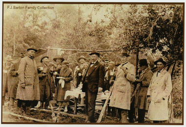
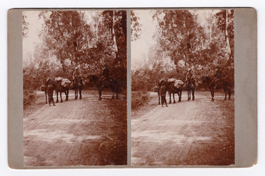
Photograph (Item) - Black and white bi-focal image, Unknown
... ...wood's point road...An early black and white bi-focal image of men and packhorses on the Marysville-Wood's Point Road in Marysville in Victoria....An early black and white bi-focal image of men and packhorses on the Marysville-Wood's Point Road in Marysville in Victoria. The images have been adhered to a piece of cardboard and the subject and location are written on the reverse of the cardboard....This is now known as the Marysville-Wood's Point Road. The Marysville-Woods Point Road was originally part of the Yarra Track, constructed in the early 1860s to provide access between Healesville and the Woods Point Goldfields. ...An early black and white bi-focal image of men and packhorses on the Marysville-Wood's Point Road in Marysville in Victoria.An early black and white bi-focal image of men and packhorses on the Marysville-Wood's Point Road in Marysville in Victoria. This is now known as the Marysville-Wood's Point Road. The Marysville-Woods Point Road was originally part of the Yarra Track, constructed in the early 1860s to provide access between Healesville and the Woods Point Goldfields. Despite the steep terrain and engineering difficulties, the Yarra Track soon became a busy route used by pack horses, horse-drawn drays, and wagons. Today this sealed mountain road is a popular scenic drive between Marysville and Warburton.Packhorses on Wood'spoint Road/ Marysville/ Victoriapackhorses, wood's point road, marysville-wood's point road, marysville, victoria, yarra track, healesville, wood's point goldfields, warburton -
 Marysville & District Historical Society
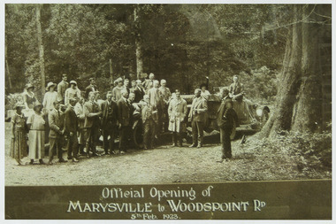
Photograph (Item) - Black and white photograph, Official Opening of MARYSVILLE to WOODSPOINT RD 5th Feb, 1923, 05-02-1924
... marysville-wood's point road...An early black and white photograph which was taken after the ceremonial re-opening of the Marysville-Wood's Point Road in 1924. The date of 1923 on the photograph is incorrect....An early black and white photograph which was taken after the ceremonial re-opening of the Marysville-Wood's Point Road in 1924....The Marysville-Woods Point Road was originally part of the Yarra Track, constructed in the early 1860s to provide access between Healesville and the Woods Point Goldfields. ...An early black and white photograph which was taken after the ceremonial re-opening of the Marysville-Wood's Point Road in 1924. The date of 1923 on the photograph is incorrect.An early black and white photograph which was taken after the ceremonial re-opening of the Marysville-Wood's Point Road in 1924. The date of 1923 on the photograph is incorrect. The Marysville-Woods Point Road was originally part of the Yarra Track, constructed in the early 1860s to provide access between Healesville and the Woods Point Goldfields. Despite the steep terrain and engineering difficulties, the Yarra Track soon became a busy route used by pack horses, horse-drawn drays, and wagons. Today this sealed mountain road is a popular scenic drive between Marysville and Warburton.Official Opening of/ MARYSVILLE to WOODSPOINT RD/ 5th Feb, 1923marysville-wood's point road, marysville, wood's point goldfields, healesville, yarra track, warburton, the argus -
 Marysville & District Historical Society
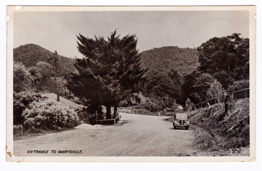
Postcard (item) - Black and white postcard, Valentine Publishing Co. Pty. Ltd, Entrance to Marysville V.11, 1923-1963
... ...marysville-wood's point road...An early black and white photograph of the Marysville-Wood's Point Road at the corner with Murchison Street in Marysville in Victoria....An early black and white photograph of the Marysville-Wood's Point Road at the corner with Murchison Street in Marysville in Victoria. ...An early black and white photograph of the Marysville-Wood's Point Road at the corner with Murchison Street in Marysville in Victoria. ...An early black and white photograph of the Marysville-Wood's Point Road at the corner with Murchison Street in Marysville in Victoria.An early black and white photograph of the Marysville-Wood's Point Road at the corner with Murchison Street in Marysville in Victoria. This postcard was published by the Valentine Publishing Co. Pty. Ltd. as a souvenir of Marysville.VALENTINE'S/ POST CARD/ A GENUINE PHOTOGRAPHmarysville, victoria, postcard, valentine publishing co, souvenir, murchison street, marysville-wood's point road -
 Marysville & District Historical Society
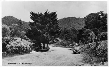
Postcard (item) - Black and white postcard, Valentine Publishing Co. Pty. Ltd, Entrance to Marysville V.11, 1923-1963
... ...marysville-wood's point road...A digital copy of an early black and white photograph of the Marysville-Wood's Point Road at the corner with Murchison Street in Marysville in Victoria....A digital copy of an early black and white photograph of the Marysville-Wood's Point Road at the corner with Murchison Street in Marysville in Victoria. ...A digital copy of an early black and white photograph of the Marysville-Wood's Point Road at the corner with Murchison Street in Marysville in Victoria. ...A digital copy of an early black and white photograph of the Marysville-Wood's Point Road at the corner with Murchison Street in Marysville in Victoria.A digital copy of an early black and white photograph of the Marysville-Wood's Point Road at the corner with Murchison Street in Marysville in Victoria. This postcard was published by the Valentine Publishing Co. Pty. Ltd. as a souvenir of Marysville.marysville, victoria, postcard, valentine publishing co, souvenir, murchison street, marysville-wood's point road -
 Marysville & District Historical Society
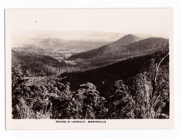
Photograph (item) - Black and white photograph, Rose Stereograph Company, Nichol's Lookout, Marysville, 1913-1967
... ...marysville-wood's point road...An early black and white photograph of the view from Nichol's Lookout which is on the Marysville-Wood's Point Road near Marysville, Victoria....An early black and white photograph of the view from Nichol's Lookout which is on the Marysville-Wood's Point Road near Marysville in Victoria. The title of the photograph is along the lower edge of the photograph....Marysville & District Historical Society 39 Darwin Street Marysville yarra-valley-and-the-dandenong-ranges An early black and white photograph of the view from Nichol's Lookout which is on the Marysville-Wood's Point Road near Marysville, Victoria. An early black and white photograph of the view from Nichol's Lookout which is on the Marysville-Wood's Point Road near Marysville, Victoria. ...An early black and white photograph of the view from Nichol's Lookout which is on the Marysville-Wood's Point Road near Marysville, Victoria.An early black and white photograph of the view from Nichol's Lookout which is on the Marysville-Wood's Point Road near Marysville, Victoria. The photograph was also used to produce the Rose Series postcard P. 2324.marysville, victoria, photograph, nichol's lookout, marysville-wood's point road, p. 2324, rose series postcard, souvenir, rose stereograph company, wood's point, mining, yarra track -
 Marysville & District Historical Society
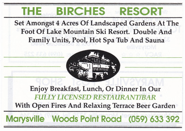
Ephemera (item) - Advertisement, THE BIRCHES RESORT, Unknown
... ...wood's point road...Wood's Point Road, Marysville, North Central, Victoria, Australia...An advertisement for THE BIRCHES RESORT in Marysville. marysville victoria australia kerami guesthouse sister elizabeth glover wood's point road kerami house pack road murchison street marysville & district tourist & progress association sister helena brayshay marion bethia curdie sister margaret vincent thomas sister elsie rose beatrice bolam mbe lesley archibald elinor macgowan mary lodge silver birch motel kufstein inn the birches kerami gardens resort the birches resort advertisement An advertisement for THE BIRCHES RESORT in Marysville. ...An advertisement for THE BIRCHES RESORT in Marysville.An advertisement for THE BIRCHES RESORT in Marysville.marysville, victoria, australia, kerami guesthouse, sister elizabeth glover, wood's point road, kerami house, pack road, murchison street, marysville & district tourist & progress association, sister helena brayshay, marion bethia curdie, sister margaret vincent thomas, sister elsie rose beatrice bolam mbe, lesley archibald elinor macgowan, mary lodge, silver birch motel, kufstein inn, the birches, kerami gardens resort, the birches resort, advertisement -
 Marysville & District Historical Society
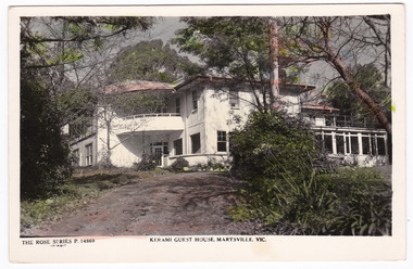
Postcard (item) - Colour postcard, Rose Stereograph Company, KERAMI GUEST HOUSE, MARYSVILLE, VIC, 1913-1967
... ...wood's point road...Wood's Point Road, Marysville, North Central, Victoria, Australia...This postcard was produced by the Rose Stereograph Company as a souvenir of Marysville. marysville victoria australia kerami guesthouse sister elizabeth glover wood's point road kerami house pack road murchison street marysville & district tourist & progress association sister helena brayshay marion bethia curdie sister margaret vincent thomas sister elsie rose beatrice bolam mbe lesley archibald elinor macgowan postcard souvenir rose series rose stereograph company p. 14869 THE ROSE SERIES P. 14869/ COPYRIGHT POST CARD The "Rose" Series/ De Luxe A Real Photograph/ Produced in Australia Published by the Rose Stereograph Co.,/ Armadale, Victoria. ...A colour postcard from Kerami Guest House in Marysville. This postcard was produced by the Rose Stereograph Company as a souvenir of Marysville.A colour postcard from Kerami Guest House in Marysville. This postcard was produced by the Rose Stereograph Company as a souvenir of Marysville.THE ROSE SERIES P. 14869/ COPYRIGHT POST CARD The "Rose" Series/ De Luxe A Real Photograph/ Produced in Australia Published by the Rose Stereograph Co.,/ Armadale, Victoria. Bill + I STAYED HERE ABOUT 3 OR 4 DAYS/ MARY, PARPS LOOKED AFTER/ STEPHEN + MARK WHEN THEY WERE/ SMALLmarysville, victoria, australia, kerami guesthouse, sister elizabeth glover, wood's point road, kerami house, pack road, murchison street, marysville & district tourist & progress association, sister helena brayshay, marion bethia curdie, sister margaret vincent thomas, sister elsie rose beatrice bolam mbe, lesley archibald elinor macgowan, postcard, souvenir, rose series, rose stereograph company, p. 14869 -
 Marysville & District Historical Society
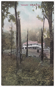
Postcard (item) - Colour postcard, "Kerami," Marysville, Unknown
... ...wood's point road...Wood's Point Road, Marysville, North Central, Victoria, Australia...The original Kerami Guesthouse was built in 1907. marysville victoria australia kerami guesthouse sister elizabeth glover wood's point road kerami house pack road murchison street marysville & district tourist & progress association sister helena brayshay marion bethia curdie sister margaret vincent thomas sister elsie rose beatrice bolam mbe lesley archibald elinor macgowan postcard souvenir POST CARD Printed in Australia This space may be used for Correspondence/ within the Commonwealth without/ extra postage THIS SPACE FOR NAME AND/ ADDRESS Stamp/ Here A colour postcard from Kerami Guesthouse in Marysville. ...A colour postcard from Kerami Guesthouse in Marysville. The original Kerami Guesthouse was built in 1907.A colour postcard from Kerami Guesthouse in Marysville. The original Kerami Guesthouse was built in 1907.POST CARD Printed in Australia This space may be used for Correspondence/ within the Commonwealth without/ extra postage THIS SPACE FOR NAME AND/ ADDRESS Stamp/ Heremarysville, victoria, australia, kerami guesthouse, sister elizabeth glover, wood's point road, kerami house, pack road, murchison street, marysville & district tourist & progress association, sister helena brayshay, marion bethia curdie, sister margaret vincent thomas, sister elsie rose beatrice bolam mbe, lesley archibald elinor macgowan, postcard, souvenir -
 Marysville & District Historical Society
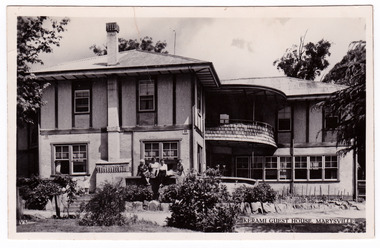
Postcard (item) - Black and white postcard, Valentine Publishing Co. Pty. Ltd, KERAMI GUEST HOUSE, MARYSVILLE, 1923-1963
... ...wood's point road...Wood's Point Road, Marysville, North Central, Victoria, Australia...Ltd. as a souvenir of Marysville. marysville victoria australia kerami guesthouse sister elizabeth glover wood's point road kerami house pack road murchison street marysville & district tourist & progress association sister helena brayshay marion bethia curdie sister margaret vincent thomas sister elsie rose beatrice bolam mbe lesley archibald elinor macgowan postcard souvenir valentine publishing co. pty. ltd. ...A black and white postcard from Kerami Guest House in Marysville. This postcard was produced by Valentine Publishing Co. Pty. Ltd. as a souvenir of Marysville.A black and white postcard from Kerami Guest House in Marysville. This postcard was produced by Valentine Publishing Co. Pty. Ltd. as a souvenir of Marysville.VALENTINE'S/ POST CARD A GENUINE PHOTOGRAPH 1954marysville, victoria, australia, kerami guesthouse, sister elizabeth glover, wood's point road, kerami house, pack road, murchison street, marysville & district tourist & progress association, sister helena brayshay, marion bethia curdie, sister margaret vincent thomas, sister elsie rose beatrice bolam mbe, lesley archibald elinor macgowan, postcard, souvenir, valentine publishing co. pty. ltd. -
 Marysville & District Historical Society
Photograph (item) - Black and white photograph, The Valentine Publishing Co. Pty. Ltd, 1923-1963
... ...wood's point road...Wood's Point Road, Marysville, North Central, Victoria, Australia...The original Kerami Guesthouse was built in 1907. marysville victoria australia kerami guesthouse sister elizabeth glover wood's point road kerami house pack road murchison street marysville & district tourist & progress association sister helena brayshay marion bethia curdie sister margaret vincent thomas sister elsie rose beatrice bolam mbe lesley archibald elinor macgowan photograph "Kerami", Marysville The COPYRIGHT of this/ PHOTOGRAPH is held by/ THE VALENTINE PUBLISHING CO. ...A black and white photograph of Kerami Guesthouse in Marysville. The original Kerami Guesthouse was built in 1907.A black and white photograph of Kerami Guesthouse in Marysville. The original Kerami Guesthouse was built in 1907."Kerami", Marysville The COPYRIGHT of this/ PHOTOGRAPH is held by/ THE VALENTINE PUBLISHING CO. PTY. LTD./ 214 QUEEN STREET, MELBOURNEmarysville, victoria, australia, kerami guesthouse, sister elizabeth glover, wood's point road, kerami house, pack road, murchison street, marysville & district tourist & progress association, sister helena brayshay, marion bethia curdie, sister margaret vincent thomas, sister elsie rose beatrice bolam mbe, lesley archibald elinor macgowan, photograph -
 Marysville & District Historical Society
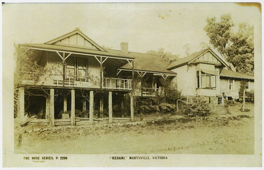
Photograph (item) - Black and white photograph, "KERAMI," MARYSVILLE, VICTORIA, Unknown
... ...wood's point road...Wood's Point Road, Marysville, North Central, Victoria, Australia...The original postcard was produced by the Rose Stereograph Company as a souvenir of Marysville. marysville victoria australia kerami guesthouse sister elizabeth glover wood's point road kerami house pack road murchison street marysville & district tourist & progress association sister helena brayshay marion bethia curdie sister margaret vincent thomas sister elsie rose beatrice bolam mbe lesley archibald elinor macgowan photograph rose series rose stereograph company p. 2298 postcard souvenir A black and white photograph of a postcard from Kerami guest house in Marysville. ...A black and white photograph of a postcard from Kerami guest house in Marysville. The original postcard was produced by the Rose Stereograph Company as a souvenir of Marysville.A black and white photograph of a postcard from Kerami guest house in Marysville. The original postcard was produced by the Rose Stereograph Company as a souvenir of Marysville.marysville, victoria, australia, kerami guesthouse, sister elizabeth glover, wood's point road, kerami house, pack road, murchison street, marysville & district tourist & progress association, sister helena brayshay, marion bethia curdie, sister margaret vincent thomas, sister elsie rose beatrice bolam mbe, lesley archibald elinor macgowan, photograph, rose series, rose stereograph company, p. 2298, postcard, souvenir -
 Marysville & District Historical Society
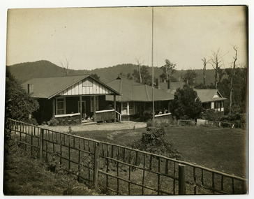
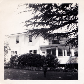
Photograph (item) - Black and white photograph, 1958
... ...wood's point road...Wood's Point Road, Marysville, North Central, Victoria, Australia...A black and white photograph of Mary Lodge Guest House in Marysville. marysville victoria australia kerami guesthouse sister elizabeth glover wood's point road kerami house pack road murchison street marysville & district tourist & progress association sister helena brayshay marion bethia curdie sister margaret vincent thomas sister elsie rose beatrice bolam mbe lesley archibald elinor macgowan mary lodge silver birch motel kufstein inn the birches kerami gardens resort the birches resort photograph A black and white photograph of Mary Lodge Guest House in Marysville. ...A black and white photograph of Mary Lodge Guest House in Marysville. The photograph was taken in 1958.A black and white photograph of Mary Lodge Guest House in Marysville.marysville, victoria, australia, kerami guesthouse, sister elizabeth glover, wood's point road, kerami house, pack road, murchison street, marysville & district tourist & progress association, sister helena brayshay, marion bethia curdie, sister margaret vincent thomas, sister elsie rose beatrice bolam mbe, lesley archibald elinor macgowan, mary lodge, silver birch motel, kufstein inn, the birches, kerami gardens resort, the birches resort, photograph -
Marysville & District Historical Society
Document (item) - Research document, Judith Vimpani, Original Kerami Guesthouse, 2021
... ...wood's point road...Wood's Point Road, Marysville, North Central, Victoria, Australia...A document outlining the history of the original Kerami Guesthouse in Marysville. marysville victoria australia kerami guesthouse sister elizabeth glover wood's point road kerami house pack road murchison street marysville & district tourist & progress association sister helena brayshay marion bethia curdie sister margaret vincent thomas sister elsie rose beatrice bolam mbe lesley archibald elinor macgowan A document outlining the history of the original Kerami Guesthouse in Marysville. ...A document outlining the history of the original Kerami Guesthouse in Marysville. The original Kerami Guesthouse was built in 1907.A document outlining the history of the original Kerami Guesthouse in Marysville.marysville, victoria, australia, kerami guesthouse, sister elizabeth glover, wood's point road, kerami house, pack road, murchison street, marysville & district tourist & progress association, sister helena brayshay, marion bethia curdie, sister margaret vincent thomas, sister elsie rose beatrice bolam mbe, lesley archibald elinor macgowan -
Marysville & District Historical Society
Document (item) - Research document, Judith Vimpani, (Hannah) Elizabeth Glover, 2016
... ...wood's point road...Wood's Point Road, Marysville, North Central, Victoria, Australia...Elizabeth Glover owned the original Kerami Guesthouse in Marysville. marysville victoria australia kerami guesthouse sister elizabeth glover wood's point road kerami house pack road murchison street marysville & district tourist & progress association sister helena brayshay marion bethia curdie sister margaret vincent thomas sister elsie rose beatrice bolam mbe lesley archibald elinor macgowan A document outlining the life of Hannah Elizabeth Glover. ...A document outlining the life of Hannah Elizabeth Glover. Elizabeth Glover owned the original Kerami Guesthouse in Marysville.A document outlining the life of Hannah Elizabeth Glover. Elizabeth Glover owned the original Kerami Guesthouse in Marysville.marysville, victoria, australia, kerami guesthouse, sister elizabeth glover, wood's point road, kerami house, pack road, murchison street, marysville & district tourist & progress association, sister helena brayshay, marion bethia curdie, sister margaret vincent thomas, sister elsie rose beatrice bolam mbe, lesley archibald elinor macgowan -
Marysville & District Historical Society
Document (item) - Biographical document, Glover, Hannah Elizabeth (c. 1855 - 1946), Unknown
... ...wood's point road...Wood's Point Road, Marysville, North Central, Victoria, Australia...Elizabeth Glover owned the original Kerami Guesthouse in Marysville. marysville victoria australia kerami guesthouse sister elizabeth glover wood's point road kerami house pack road murchison street marysville & district tourist & progress association sister helena brayshay marion bethia curdie sister margaret vincent thomas sister elsie rose beatrice bolam mbe lesley archibald elinor macgowan A biography of Hannah Elizabeth Glover. ...A biography of Hannah Elizabeth Glover. Elizabeth Glover owned the original Kerami Guesthouse in Marysville.A biography of Hannah Elizabeth Glover. Elizabeth Glover owned the original Kerami Guesthouse in Marysville.marysville, victoria, australia, kerami guesthouse, sister elizabeth glover, wood's point road, kerami house, pack road, murchison street, marysville & district tourist & progress association, sister helena brayshay, marion bethia curdie, sister margaret vincent thomas, sister elsie rose beatrice bolam mbe, lesley archibald elinor macgowan -
Marysville & District Historical Society
Document (item) - Obituary, "A Nightingale Sang...", 21-08-1946
... ...wood's point road...Wood's Point Road, Marysville, North Central, Victoria, Australia...Elizabeth Glover owned the original Kerami Guesthouse in Marysville. marysville victoria australia kerami guesthouse sister elizabeth glover wood's point road kerami house pack road murchison street sister margaret thomas marysville & district tourist & progress association sister helena brayshay marion bethia curdie sister elsie rose beatrice bolam mbe lesley archibald elinor macgowan The obituary of Hannah Elizabeth Glover taken from The Advocate on August 21st 1946. ...The obituary of Hannah Elizabeth Glover taken from The Advocate on August 21st 1946. Elizabeth Glover owned the original Kerami Guesthouse in Marysville.The obituary of Hannah Elizabeth Glover taken from The Advocate on August 21st 1946. Elizabeth Glover owned the original Kerami Guesthouse in Marysville.marysville, victoria, australia, kerami guesthouse, sister elizabeth glover, wood's point road, kerami house, pack road, murchison street, sister margaret thomas, marysville & district tourist & progress association, sister helena brayshay, marion bethia curdie, sister elsie rose beatrice bolam mbe, lesley archibald elinor macgowan -
Marysville & District Historical Society
Document (item) - Research document, Judith Vimpani, Marion Bethia Curdie 1867-1929, 2016
... ...wood's point road...Wood's Point Road, Marysville, North Central, Victoria, Australia...Alongside Hannah Elizabeth Glover, Marion owned the original Kerami Guesthouse in Marysville. marysville victoria australia kerami guesthouse sister elizabeth glover wood's point road kerami house pack road murchison street marysville & district tourist & progress association sister helena brayshay marion bethia curdie sister margaret vincent thomas sister elsie rose beatrice bolam mbe lesley archibald elinor macgowan A document outlining the life of Marion Bethia Curdie. ...A document outlining the life of Marion Bethia Curdie. Alongside Hannah Elizabeth Glover, Marion owned the original Kerami Guesthouse in Marysville.A document outlining the life of Marion Bethia Curdie. Alongside Hannah Elizabeth Glover, Marion owned the original Kerami Guesthouse in Marysville.marysville, victoria, australia, kerami guesthouse, sister elizabeth glover, wood's point road, kerami house, pack road, murchison street, marysville & district tourist & progress association, sister helena brayshay, marion bethia curdie, sister margaret vincent thomas, sister elsie rose beatrice bolam mbe, lesley archibald elinor macgowan -
Marysville & District Historical Society
Document (item) - Research document, Judith Vimpani, Margaret Vincent Thomas c1871-1967, 2017
... ...wood's point road...Wood's Point Road, Marysville, North Central, Victoria, Australia...Margaret worked with Elizabeth Glover at the original Kerami Guesthouse in Marysville from 1908 to 1914. marysville victoria australia kerami guesthouse sister elizabeth glover wood's point road kerami house pack road murchison street marysville & district tourist & progress association sister helena brayshay marion bethia curdie sister margaret vincent thomas sister elsie rose beatrice bolam mbe lesley archibald elinor macgowan A document outlining the life of Margaret Vincent Thomas. ...A document outlining the life of Margaret Vincent Thomas. Margaret worked with Elizabeth Glover at the original Kerami Guesthouse in Marysville from 1908 to 1914.A document outlining the life of Margaret Vincent Thomas. Margaret worked with Elizabeth Glover at the original Kerami Guesthouse in Marysville from 1908 to 1914.marysville, victoria, australia, kerami guesthouse, sister elizabeth glover, wood's point road, kerami house, pack road, murchison street, marysville & district tourist & progress association, sister helena brayshay, marion bethia curdie, sister margaret vincent thomas, sister elsie rose beatrice bolam mbe, lesley archibald elinor macgowan -
Marysville & District Historical Society
Document (item) - Research document, Judith Vimpani, Helena (Lena) Brayshay 1863-1919, 2017
... ...wood's point road...Wood's Point Road, Marysville, North Central, Victoria, Australia...Helena managed Kerami, with the assistance of Elsie Bolam, for a short period of time until her early death in 1919. marysville victoria australia kerami guesthouse sister elizabeth glover wood's point road kerami house pack road murchison street marysville & district tourist & progress association sister helena brayshay marion bethia curdie sister margaret vincent thomas sister elsie rose beatrice bolam mbe lesley archibald elinor macgowan A document outlining the life of Helena (Lena) Brayshay. ...A document outlining the life of Helena (Lena) Brayshay. Helena Brayshay purchased the original Kerami Guesthouse from Elizabeth Glover in 1914. Helena managed Kerami, with the assistance of Elsie Bolam, for a short period of time until her early death in 1919.A document outlining the life of Helena (Lena) Brayshay. Helena Brayshay purchased the original Kerami Guesthouse from Elizabeth Glover in 1914. Helena managed Kerami, with the assistance of Elsie Bolam, for a short period of time until her early death in 1919.marysville, victoria, australia, kerami guesthouse, sister elizabeth glover, wood's point road, kerami house, pack road, murchison street, marysville & district tourist & progress association, sister helena brayshay, marion bethia curdie, sister margaret vincent thomas, sister elsie rose beatrice bolam mbe, lesley archibald elinor macgowan -
Marysville & District Historical Society
Document (item) - Research document, Judith Vimpani, Elsie Rose Beatrice Bolam MBE 1879-1965, 2018
... ...wood's point road...Wood's Point Road, Marysville, North Central, Victoria, Australia...Elsie Bolam owned the original Kerami Guesthouse from 1919 until the end of the 1920s. marysville victoria australia kerami guesthouse sister elizabeth glover wood's point road kerami house pack road murchison street marysville & district tourist & progress association sister helena brayshay marion bethia curdie sister margaret vincent thomas sister elsie rose beatrice bolam mbe lesley archibald elinor macgowan A document outlining the life of Elsie Rose Beatrice Bolam MBE. ...A document outlining the life of Elsie Rose Beatrice Bolam MBE. Sister Elise Bolam was in Marysville for over 40 years, almost all of that time with her companion Sister Lesley MacGowan. Elsie Bolam owned the original Kerami Guesthouse from 1919 until the end of the 1920s.A document outlining the life of Elsie Rose Beatrice Bolam MBE. Sister Elise Bolam was in Marysville for over 40 years, almost all of that time with her companion Sister Lesley MacGowan. Elsie Bolam owned the original Kerami Guesthouse from 1919 until the end of the 1920s.marysville, victoria, australia, kerami guesthouse, sister elizabeth glover, wood's point road, kerami house, pack road, murchison street, marysville & district tourist & progress association, sister helena brayshay, marion bethia curdie, sister margaret vincent thomas, sister elsie rose beatrice bolam mbe, lesley archibald elinor macgowan -
Marysville & District Historical Society
Document (item) - Research document, Judith Vimpani, Lesley Archibald Elinor MacGowan 1882-1966, 2016
... ...wood's point road...Wood's Point Road, Marysville, North Central, Victoria, Australia...Elsie owned the original Kerami Guesthouse from 1919 until the end of the 1920s. marysville victoria australia kerami guesthouse sister elizabeth glover wood's point road kerami house pack road murchison street marysville & district tourist & progress association sister helena brayshay marion bethia curdie sister margaret vincent thomas sister elsie rose beatrice bolam mbe lesley archibald elinor macgowan A document outlining the life of Lesley Archibald Elinor MacGowan. ...A document outlining the life of Lesley Archibald Elinor MacGowan. Lesley MacGowan was the lifelong companion of Elsie Bolam. Elsie owned the original Kerami Guesthouse from 1919 until the end of the 1920s.A document outlining the life of Lesley Archibald Elinor MacGowan. Lesley MacGowan was the lifelong companion of Elsie Bolam. Elsie owned the original Kerami Guesthouse from 1919 until the end of the 1920s.marysville, victoria, australia, kerami guesthouse, sister elizabeth glover, wood's point road, kerami house, pack road, murchison street, marysville & district tourist & progress association, sister helena brayshay, marion bethia curdie, sister margaret vincent thomas, sister elsie rose beatrice bolam mbe, lesley archibald elinor macgowan