
Showing 9 items matching "woolshed mine"
-
 The Beechworth Burke Museum
Photograph - Photograph - Reproduction
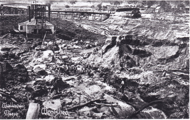
... woolshed mine...The Woolshed mines continued with miners using sluicing methods until John Wallace's arrival in the area in the 1890s. ...Obverse: Wallace's Mine / Woolshed Reverse: 7789 / Wallance's Mine / Woolshed...The photograph is useful in historical research because of its visual representation of dredging methods. The Woolshed mine pictured was initially prosperous in the 1850s, but was revived in the 1890s by Wallace's mining company. woolshed mine john wallace mining goldmining beechworth beechworth burke museum gold sluicing gold mining Obverse: Wallace's Mine / Woolshed Reverse: 7789 / Wallance's Mine / Woolshed Black and white rectangular photograph reproduction of card. ...Wallace's mine (as noted on the photograph) was owned by John Wallace - a businessman from Scotland who come to Australia in 1852. He owned several hotels and mining companies, including the Chiltern Valley Mines Co. Wallace introduced dredging to the Woolshed diggings near Beechworth as a technique for mining. He employed hundreds of miners through his mining company alone. The Woolshed mine was opened in 1853, but all but abandoned by 1855. The Woolshed mines continued with miners using sluicing methods until John Wallace's arrival in the area in the 1890s. Wallace's company used a dredge and Jennings pump to find gold deposits, moving on from the sluicing methods. The availability of water in the Woolshed area made it possible to use these techniques of mining. This reproduction photograph has historic significance because it portrays the mining works run by John Wallace's company in the Woolshed area. Wallace's use of dredging to find gold is evident through the decay of the land. The photograph is useful in historical research because of its visual representation of dredging methods. The Woolshed mine pictured was initially prosperous in the 1850s, but was revived in the 1890s by Wallace's mining company. Black and white rectangular photograph reproduction of card. White label sticker on reverse with inscriptionObverse: Wallace's Mine / Woolshed Reverse: 7789 / Wallance's Mine / Woolshedwoolshed mine, john wallace, mining, goldmining, beechworth, beechworth burke museum, gold sluicing, gold mining -
 Federation University Historical Collection
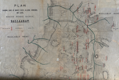
Plan, White Horse Range Ballarat, 1885, 06/1885
... Woolshed Lead, Jacksons Lead, Winters Lead, SCtochman's Lead, Canadian Lead. Reefs include: Promised Land, Daniash, Sir Garnet Wolsley, Norwegian, Rothschile, Band and Albion, Finns, Llanberis, Roberts Lode, Tynworths and Black Hill, Oregan, Yorkshire, Try Again, Yorkshire, Post Office, Clarke's, Western Slates, Black Slate, Danks Slates, Eastern Slates, Queen's Lode, Fire Brigade. Mines...Woolshed Lead, Jacksons Lead, Winters Lead, SCtochman's Lead, Canadian Lead. Reefs include: Promised Land, Daniash, Sir Garnet Wolsley, Norwegian, Rothschile, Band and Albion, Finns, Llanberis, Roberts Lode, Tynworths and Black Hill, Oregan, Yorkshire, Try Again, Yorkshire, Post Office, Clarke's, Western Slates, Black Slate, Danks Slates, Eastern Slates, Queen's Lode, Fire Brigade. Mines ...Two plans .1) Plan of the Ballarat Goldfields showing leads, rivers, streets and topography. Quartz reefs include: Yorkshire, Try Again, Promised Land, Western Slates, Norwegian, Robert's Lode, Finn's, Band and albion, Rothschild, Old Post Office, Queen Lode. Leads include: Navy jacks, Gays, Canadian, Prince Regent, Sailors Gully, White Horse, Little White Horse, Milkmans, Nightingale, Golden Point, Gravel Pits. Scale is 8 Chains to 1 inch .2) Plan showing lines of quartz reefs, alluvial workings and leads, White Horse Range, Ballarat. Leads include White Horse LEad, Little White Horse Lead, One Eye Gully, Terrible Lead, Sailor's Gully, Canadian Lead, Prince Regent Gully, Canadian Lead, Cavs Lead, Navy jacks Lead, Eureka Lead, Old Gravel Pits Lead, Gravel Pits Lead, Nightingale Lead, Malakoff Lead, Milkmans Lead, Redan Lead, Woolshed Lead, Jacksons Lead, Winters Lead, SCtochman's Lead, Canadian Lead. Reefs include: Promised Land, Daniash, Sir Garnet Wolsley, Norwegian, Rothschile, Band and Albion, Finns, Llanberis, Roberts Lode, Tynworths and Black Hill, Oregan, Yorkshire, Try Again, Yorkshire, Post Office, Clarke's, Western Slates, Black Slate, Danks Slates, Eastern Slates, Queen's Lode, Fire Brigade. Mines include Red Streak, New Chum, Tinworths, Woah Hawp, Normanby, Speedwell, Llanberris Extended, Llanberis, Last Chance, Major, Countess, Pioneer and a number of batteries along Main Road Hills include: Mount Clear, Pennyweight Hill, Sovereign Hillballarat, plan, white horse range, white horse, goldfields, mines, reefs, indicators, leigh river, cgt, tinworth, mining -
 The Beechworth Burke Museum
Photograph, c1885
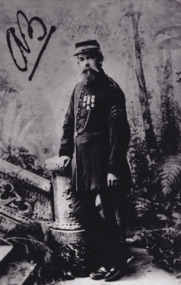
... He mined for short time at Back Creek Bendigo, then went to the Ovens where he sought gold in Spring Creek, Buckland and 3 Mile. After moving to Albury for 18 months he married Anna, moved to Woolshed and was there for two years mining gold. ...He mined for short time at Back Creek Bendigo, then went to the Ovens where he sought gold in Spring Creek, Buckland and 3 Mile. After moving to Albury for 18 months he married Anna, moved to Woolshed and was there for two years mining gold. ...This carte de visite was taken of Hiram Crawford in fire brigade uniform taken by Stewart & CO., Melbourne. Hiram Crawford was Captain of the Beechworth Volunteer Fire Brigade for twenty-five years. Hiram arrived in Australia at the age of 21 in August 1853. He mined for short time at Back Creek Bendigo, then went to the Ovens where he sought gold in Spring Creek, Buckland and 3 Mile. After moving to Albury for 18 months he married Anna, moved to Woolshed and was there for two years mining gold. After discovering his fortune he formed Crawford and Co. Coaching Lines in Beechworth in late 1856. It was this company which became the longest surviving coaching business in the State of Victoria. Hiram and Anna had two daughters. Anna died in March 1862 and in May Hiram left from Melbourne to return to the United States on a visit. Hiram married Martha Foster during this visit and returned to Australia in March 1863. With his coach line established, and leaving it under management, he moved around the north east of Victoria establishing and building shops and the Star Hotel and Theatre in Chiltern in 1866. In 1869 he moved to Melbourne for a few years in which time he built the Eastern Arcade in Bourke Street. In 1876 the family returned to Beechworth for a few years eventually moving to Everton where Hiram grew hops, tobacco, fruit trees and established the largest lemon orchard at that time in Australia. Hiram spent a considerable amount of his time helping to develop the North East of the State not only in his private endeavours but as a public figure. Among his many achievements a few are listed - Councillor, Mayor of Chiltern and Beechworth, President of the Shire on two occasions, Director of many mining companies, Inaugural Chairman and Director of the Beechworth Gas Company roles he held for over 20 years, Foundation member of Beechworth Pottery, Committee member of the Beechworth Hospital, Captain/Superintendent of the Vol. Fire Brigade for over 20 years, Foundation, Life member of and on the State Fire Brigade Board for many years, President of the North Eastern Railway League in Chiltern On a personal level Hiram was involved in lodges including St. Johns #14, Beechworth. and had several grazing properties in the Ovens area. He had the Forest Park Hotel at Carboor, the Creamery at Carboor, and grazing land on which the Milawa Creamery was built during his ownership. He was a committee member for 3 committees duirng the 1888 International Exhibition in Melbourne. Hiram had many voyages around the world studying irrigation, hop growing, tobacco growing and drying. During his retirement in Melbourne Hiram purchased many properties in the Elsternwick area and acted as an Estate Agent. After the death of his second wife Martha, Hiram married for the third time in 1912 to Sophia Maude Heatley. Crawford and Co continued until 1921. [Taken from HighCountryHeritage.com.au]Black and white reproduction of a studio portrait of Hiram Crawford in fire brigade uniform, printed on gloss photographic paper and bordered with a white frame.Badge on uniform sleeve reads: CAPTAIN / BVFB Obverse: AB/ Stewart & CO./ Melbourne Reverse: Hiram Collection/ BMM2435burke museum, emergency services, beechworth, carte de visite, black and white, fire brigade, hiram crawford, stewart & co., melbourne. -
 Tarnagulla History Archive
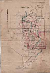
Linen-Backed Map of Poseidon Goldfield, c1915, with Mining Leases and Shaft locations
... Mines Department or other Government surveyor with the intention of assisting to attract mining capital to the goldfield. The red sketched-in deep lead positions are inaccurate. The pencil notation upper left reads "Lowther's Lease 6415". Lowther was a Tarnagulla mining promoter of the time. The Tarnagulla Racecourse location is marked as is the Woolshed...Mines Department or other Government surveyor with the intention of assisting to attract mining capital to the goldfield. The red sketched-in deep lead positions are inaccurate. The pencil notation upper left reads "Lowther's Lease 6415". Lowther was a Tarnagulla mining promoter of the time. The Tarnagulla Racecourse location is marked as is the Woolshed ...This is a very nice foolscap-size map, probably prepared by a Mines Department or other Government surveyor with the intention of assisting to attract mining capital to the goldfield. The red sketched-in deep lead positions are inaccurate. The pencil notation upper left reads "Lowther's Lease 6415". Lowther was a Tarnagulla mining promoter of the time. The Tarnagulla Racecourse location is marked as is the Woolshed Reef State School. -
 Wooragee Landcare Group
Photograph, circa April 2003
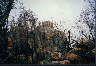
... It's most notable landmarks include Mt Pilot and Woolshed Falls. It also has many mines from the Gold Rush in the late 1800s. ...It's most notable landmarks include Mt Pilot and Woolshed Falls. It also has many mines from the Gold Rush in the late 1800s. ...This photograph was taken in the Mount Pilot Chiltern National Park. This park is located near Chiltern in Victoria. It's most notable landmarks include Mt Pilot and Woolshed Falls. It also has many mines from the Gold Rush in the late 1800s. It is home to much flora and fauna, including the tiger quoll. The tiger quoll, also known as the spotted-tail quoll, is a marsupial that gives in the Mount Pilot Chiltern National Park. It is also main land Australia's largest carnivorous marsupial. It can weigh up too four kilograms and looks similar to either a possum or a spotted cat. It has red and brown fur with distinct spots. The tiger quoll is found along the Great Dividing Range, which includes Victoria, New South Wales and also near the border of Queensland. It lives in forests, rainforests and coastal heathlands and woodlands. In 2004 a team of volunteers from the Wooragee Landcare group as well as some of the Department of Sustainability and Environment staff set out to find the tiger quoll following the 2003 bushfires. Since the bushfires, concern had arisen for it because it hadn't been seen since the bushfires. They attempted to find traces of the quoll through finding and identifying their droppings as well as DNA testing. This photograph was taken during this search. This photograph represents the work that goes into protecting a important species like the tiger quoll. The tiger quoll is a significant species because it is main land Australia's largest carnivorous marsupial. As a result of this, there has been much work done to preserve and protect it. This photograph was taken when the Wooragee Landcare group went to ensure the survival of this species, highlighting how the tiger quoll is being protected. This photograph also demonstrates the impacts of the 2003 bushfires in the Mount Pilot Chiltern National Park. This is seen through the burnt trees featured in the picture. Landscape coloured photograph printed on gloss paperReverse: WAN NA 0ANA0N0 NNN 0 1636 / [PRINTED] (No.7) / 921quoll, mount pilot chiltern national park, national park, 2003 bushfires, search, endangered, beechworth, wooragee landcare group, wooragee landcare, wooragee, possum, australia, victoria, department of sustainability and environment, photograph, 2004, spotted-tailed quoll, great dividing range, spots, fur, forests, rainforests, woodlands, coastal heathlands, spotted quoll, spotted quoll habitat -
 Wooragee Landcare Group
Photograph, circa April 2003
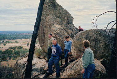
... It's most notable landmarks include Mt Pilot and Woolshed Falls. It also has many mines from the Gold Rush in the late 1800s. ...It's most notable landmarks include Mt Pilot and Woolshed Falls. It also has many mines from the Gold Rush in the late 1800s. ...This photograph was taken in the Mount Pilot Chiltern National Park. It was taken during a search for the tiger quoll conducted by a team of volunteers from the Wooragee Landcare Group. The tiger quoll is also known as the spotted-tail quoll and is found in the national park. The 2003 bushfires caused worry for the safety of the tiger quoll, hence the need for a search for it. Mount Pilot Chiltern National Park is located near Chiltern in Victoria. It's most notable landmarks include Mt Pilot and Woolshed Falls. It also has many mines from the Gold Rush in the late 1800s. It is home to much flora and fauna, including the tiger quoll. The park is also home to the box-ironbark forest that once was present in most of north-eastern Victoria. The park is a large tourist destination as in there are many bushwalks and other attractions for visitors. In 2003, bushfires raged through Mount Pilot National Park and destroyed much of the environment. Some of this damage can be seen in the burnt trees in the picture. This photograph represents the work that goes into protecting a important species like the tiger quoll and there has been much work done to preserve it. This photograph was taken when the Wooragee Landcare group went to ensure the survival of this species, highlighting how the tiger quoll is being protected. This photograph also demonstrates the significance of Mount Pilot Chiltern National Park. The park has many special flora and fauna that can only be found in this area. For example, the box-ironbark forest and the tiger quoll. The forest used to stretch over much of north-eastern Victoria and is therefore reminiscent of what that area of Victoria was once like. This park is historical for this reason but it is also historical through it being once goldfields from the Gold Rush in the 1800s.Landscape coloured photograph printed on gloss paperReverse: WAN NA 0ANA2N0 NNN- 1 1636 / [PRINTED] (No.8) / 922mount pilot, mount pilot chiltern national park, chiltern, victoria, landmark, woolshed falls, gold rush, tiger quoll, flora, fauna, spotted tail quoll, marsupial, andy murray, andy murray quolls, carnivorous marsupial, forests, rainforests, coastal heathlands, woodlands, photograph, species, wooragee, wooragee landcare group, wooragee landcare, bushfires, identification, search, dna, droppings, box ironbark forest, ironbark, box iron bark -
 The Beechworth Burke Museum
Photograph - Photograph - Reproduction, c1920
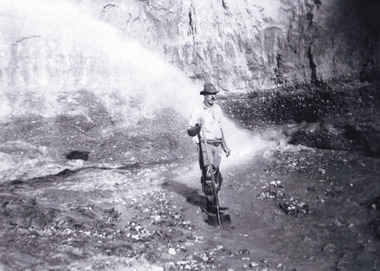
... Three Mile Mine was a major site of mining activity sating back to the 1850s, although was often not as prosperous as other sites such as those situated on the Woolshed Valley. ...Three Mile Mine was a major site of mining activity sating back to the 1850s, although was often not as prosperous as other sites such as those situated on the Woolshed Valley. ...This photograph depicts mining operations (in particular, hydrolic sluicing) at Three Mile Mine, Barramutha, during the later periods of mining, 1920s-1950s. Three Mile Mine was a major site of mining activity sating back to the 1850s, although was often not as prosperous as other sites such as those situated on the Woolshed Valley. Many miners would leave Three Mile Mine for better prospects on other claims. The main, most successful 'rush' at Three Mile Mine occurred during and immediately following September 1855. This photograph, however, depicts a much later period.The search for gold is ingrained into the history of Victoria and therefore, images like this one which portray a miner at a sluicing site can reveal important information for society and technology for the date when the photograph was taken. This image, and its related images, it important for its historical significant of labour and mining extraction used for gold during the latter gold rushes in the 1900s. The Beechworth Burke Museum has additional images relating to gold mining in the region which can be analysed and studied alongside images like this one.A black and white rectangular photograph printed on matte photographic paperreverse: 7597.4 / copied from original on loan from Webb (Qld) / Donated Nov 2009 / Baarmutha Three Mile Mine 1920-1950 / Owned by Plain Bros then Parkinsons / John Weir or Jack Cox / Sluicing /mining, barramutha, three mile mine, sluicing, mine, beechworth -
 The Beechworth Burke Museum
Photograph, c1920
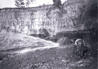
... Mine, Beechworth . The Beechworth Mining District was one of six mining districts established by the Governor-in-Council on 4 January 1858 under the provisions of An Act for Amending the Laws Relating to the Goldfields (21 Vic no.32). The District was further divided into seven divisions: Spring Creek, Snake Valley, Three Mile Creek, Buckland, Woolshed...Mine, Beechworth . The Beechworth Mining District was one of six mining districts established by the Governor-in-Council on 4 January 1858 under the provisions of An Act for Amending the Laws Relating to the Goldfields (21 Vic no.32). The District was further divided into seven divisions: Spring Creek, Snake Valley, Three Mile Creek, Buckland, Woolshed ...This photo shows the large mining cavity with a hydraulic sluicing machine in operation at Baarmutha Three Mile Mine, Beechworth . The Beechworth Mining District was one of six mining districts established by the Governor-in-Council on 4 January 1858 under the provisions of An Act for Amending the Laws Relating to the Goldfields (21 Vic no.32). The District was further divided into seven divisions: Spring Creek, Snake Valley, Three Mile Creek, Buckland, Woolshed, Yackandandah and Omeo. The boundaries of each of these divisions and of the whole district are described in the Governor-in-Council's proclamation printed in the Government Gazette, 5 January 1858, pages 3-5. Hydraulic mining is a form of mining that uses high-pressure jets of water to dislodge rock material or move sediment. In the placer mining of gold or tin, the resulting water-sediment slurry is directed through sluice boxes to remove the gold. It is also used in mining kaolin and coal.This photograph shows the impact the gold rush era had on Australia and the earth.A black and white rectangular photograph printed on photographic paperCopied from original on loan film (WEBB QLD) / Donated 2009 NOV/ Baarmutha Three Mile Mine c1920-1950/ Managed by John Weir Peter Jereen Jack Cox / Owned by Plain Bros then Parkinsons Sluicing.mining, gold fields, beechworth, gold rush, burke museum, photograph, mining cavity, hydraulic mining, hydraulic sluicing, baarmutha -
 The Beechworth Burke Museum
Photograph
... mine workers. Some appear to be inspecting or interacting with the equipment. Three Mile was a part of the Beechworth Mining District which was established in 1858. The District contained seven divisions: Spring Creek, Snake Valley, Three Mile Creek, Buckland, Woolshed, Yackandandah and Omeo. ...mine workers. Some appear to be inspecting or interacting with the equipment. Three Mile was a part of the Beechworth Mining District which was established in 1858. The District contained seven divisions: Spring Creek, Snake Valley, Three Mile Creek, Buckland, Woolshed, Yackandandah and Omeo. ...Taken in the 1950s, depicted is a crowd of men, women and children in a mine cutting at the Three Mile Mine, Baarmutha. The majority of the crowd do not appear to be mine workers. Some appear to be inspecting or interacting with the equipment. Three Mile was a part of the Beechworth Mining District which was established in 1858. The District contained seven divisions: Spring Creek, Snake Valley, Three Mile Creek, Buckland, Woolshed, Yackandandah and Omeo. Over time the role of Mining Districts was reduced until the Beechworth Mining District, and other Mining Districts in the area, was put under the administration of the Mines Department in 1975. Water races were commonly used in gold mining as the miners require large volumes of water to separate the gold from the dirt. Beechworth was the site of many firsts in Victorian colonial goldfield water management. Laws and regulations for water management and the control of water rights were established at Beechworth. The first Victorian water permits were also issued there, and the first sales of water for mining. This photograph is historically significant as an example of the importance of the gold rush in Beechworth. The photograph also depicts water infrastructure which has a significant history regarding usage and policy development within the Beechworth Mining District. Black and white square photograph printed on matte photographic paper.Reverse: SW-50-1 / 1997 3140 / unreadable pencil markingsbeechworth mining district, three mile creek division, three mile creek, three mile mine, water race, water races, mining, pipe, baarmutha, gold mining, sluicing
