Showing 7493 items matching yarra valley
-
 Ringwood and District Historical Society
Envelope, Packet: Yarra Valley Church of England School - Founding 1965, Papers, Opening, Land Sales etc
... Packet: Yarra Valley Church of England School - Founding...Yarra Valley Church of England School; Founding 1965... Road Ringwood North melbourne Envelope Packet: Yarra Valley ...Yarra Valley Church of England School; Founding 1965; Building Appeal 1964, 1968; Service for unveiling and dedication of plaque; Service for opening of school; Notes on land sales -
 Ringwood and District Historical Society
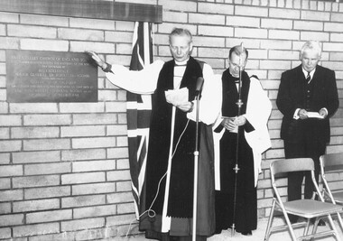
Photograph, Archbishop Frank Woods (left) and Sir Rohan Delacombe (right) pictured at Ringwood's Yarra Valley Church of England School dedication - October, 1965. The inscription on the plaque reads, "Yarra Valley Church of England School. This plaque commemorating the founding of the school was unveiled by His Excellency Major General Sir Rohan Delacombe, Governor of Victoria on October 2nd 1965 and was dedicated on that date by the Most Reverend Frank Woods, M.A., D.D., Archbishop of Melbourne"
... (right) pictured at Ringwood's Yarra Valley Church of England...The inscription on the plaque reads, "Yarra Valley Church... Yarra Valley Church of England School dedication - October, 1965 ...The inscription on the plaque reads, "Yarra Valley Church of England School. This plaque commemorating the founding of the school was unveiled by His Excellency Major General Sir Rohan Delacombe ... Governor of Victoria on October 2nd 1965 and was dedicated on that date by the Most Reverend Frank Woods, M.A., D.D., Archbishop of Melbourne". -
 Eltham District Historical Society Inc
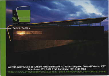
Postcard - Photograph, Evelyn County Estate, Yarra Valley, c.2009
... Evelyn County Estate, Yarra Valley...Yarra Valley... melbourne Photograph Postcard Evelyn County Estate, Yarra Valley ...The Evelyn Country Estate, Cellar Door and Black Paddock restaurant and Tony Smibert Gallery opened on 26 April 2001 and officially opened on 18 May 2001 by Roger and Robyn Male - KGC Winter 2001evelyn county estate, kangaroo ground, postcard, yarra valley, restaurant -
 Eltham District Historical Society Inc
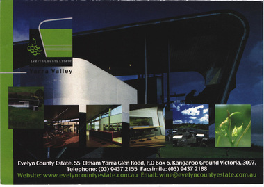
Postcard - Photograph, Evelyn County Estate, Yarra Valley, c.2009
... Evelyn County Estate, Yarra Valley...Yarra Valley... melbourne Photograph Postcard Evelyn County Estate, Yarra Valley ...The Evelyn Country Estate, Cellar Door and Black Paddock restaurant and Tony Smibert Gallery opened on 26 April 2001 and officially opened on 18 May 2001 by Roger and Robyn Male - KGC Winter 2001evelyn county estate, kangaroo ground, postcard, yarra valley, restaurant -
 Monbulk RSL Sub Branch
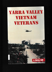
Book, Mt Evelyn RSL Sub-Branch, Yarra Valley Vietnam Veterans, 2018
... Yarra Valley Vietnam Veterans...Veterans - Victoria - Yarra valley - Biography...Monbulk RSL Sub Branch 48 Main Road Monbulk yarra-valley ...Fifty years after they served Australia in the Vietnam War, sixteen veterans of that conflict from the Yarra Valley sat down with the Mt Evelyn RSL's historian and revealed, some for the first time, their wartime experiences.Their stories tell of our nation's involvement in Vietnam and spans the period 1964 to 1972. They served with the Navy, with the Regular Army, with the CMF and as National Servicemen. Their backgrounds varied as much as their experiences 'in country' during that time.It is a story of sacrifice and endurance, bravery and loss, good times and bad times. It reveals the environment they were forced to exist in and the role they played, from the mundane to the terrifying.Surviving all of this they then returned home to a nation where many people ignored or even condemned them. For most, those decades after the war were an ongoing battle to deal with the physical and mental scars.Ill, p.464.non-fictionFifty years after they served Australia in the Vietnam War, sixteen veterans of that conflict from the Yarra Valley sat down with the Mt Evelyn RSL's historian and revealed, some for the first time, their wartime experiences.Their stories tell of our nation's involvement in Vietnam and spans the period 1964 to 1972. They served with the Navy, with the Regular Army, with the CMF and as National Servicemen. Their backgrounds varied as much as their experiences 'in country' during that time.It is a story of sacrifice and endurance, bravery and loss, good times and bad times. It reveals the environment they were forced to exist in and the role they played, from the mundane to the terrifying.Surviving all of this they then returned home to a nation where many people ignored or even condemned them. For most, those decades after the war were an ongoing battle to deal with the physical and mental scars.vietnam war 1961-1975 – personal recollections – australia, veterans - victoria - yarra valley - biography -
 Eltham District Historical Society Inc
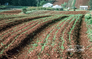
Photograph, Fred Mitchell, Market garden, Yarra Valley, 1980
... Market garden, Yarra Valley, 1980...Yarra Valley... melbourne Photograph Market garden, Yarra Valley, 1980 Digital copy ...Digital copy of colour photographfred mitchell collection, yarra valley, 1980, market gardens -
 Eltham District Historical Society Inc
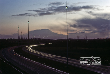
Photograph, Fred Mitchell, Yarra Valley, Bulleen, 1983
... Yarra Valley, Bulleen, 1983...Yarra Valley... melbourne Photograph Yarra Valley, Bulleen, 1983 Digital copy ...Digital copy of colour photographfred mitchell collection, 1983, yarra valley, bulleen -
 Eltham District Historical Society Inc
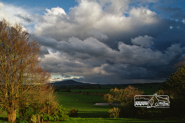
Photograph, Fred Mitchell, Approaching storm, Yarra Valley, Tarrawingee, 1990
... Approaching storm, Yarra Valley, Tarrawingee, 1990...Yarra Valley... melbourne Photograph Approaching storm, Yarra Valley, Tarrawingee ...Home of Frederick William Mitchell, chemical engineer and his wife, Marjorie Nell Mitchell, teacher.Digital copy of colour photographfred mitchell collection, yarra valley, tarrawingee, 1990 -
 Darebin Art Collection
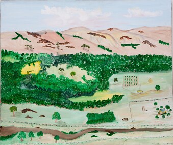
Painting - Aunty Gwen Garoni, Aunty Gwen Garoni, Regrowth in the Yarra Valley, 2011
... Regrowth in the Yarra Valley...yarra valley... Regrowth in the Yarra Valley landscape yarra valley Aunty Gwen ...landscape, yarra valley -
 Kew Historical Society Inc
Photograph - Flooding of the Yarra Valley at Kew East, 1974
... Flooding of the Yarra Valley at Kew East...Flooding of the Yarra Valley, including that section... Flooding of the Yarra Valley at Kew East Photograph Original black ...Flooding of the Yarra Valley, including that section of the Yarra bordering Kew and Kew East in the north and west of the municipality, was a regular occurrence. Extreme flood events of the Yarra River are recorded to have occurred in 1891, 1901, 1916, 1923 and 1934. The Municipality of Kew's response to these floods was to enact planning decisions restricting residential development in flood prone areas following the floods of 1916, 1921 and 1934. While floods continued after the development of the Upper Yarra Reservoir (construction 1948-57), the regularity and extent of these inundations diminished. During the nineteenth century, the land abutting the south side of the Yarra in Kew was devoted to dairy farming. In the twentieth century, before and after the construction of the Eastern Freeway, much of this low-lying area was used as golf courses and public parks.Late example of the capacity of the Yarra Valley at Kew to flood, even though drainage works and the Upper Yarra Reservoir had reduced their regularity.Original black and white print photograph of the low-lying land at East Kew under floodwater on 16 May 1974. The vantage point of the photographer is Lister Street. In the photo, the fences of the Kilby Farm can be seen. Flooding was caused by overflowing water in Glass' Creek and the River Yarra. Annotation verso: "Hay's Paddock op No.30 Lister Street / 16 May 1974 11.50am / R.L. 46.04"hays paddock, floods, yarra river, glass' creek, lister street -
 Kew Historical Society Inc
Photograph - Flooding of the Yarra Valley at Kew East, 1974
... Flooding of the Yarra Valley at Kew East...Flooding of the Yarra Valley, including that section... Flooding of the Yarra Valley at Kew East Photograph Original black ...Flooding of the Yarra Valley, including that section of the Yarra bordering Kew and Kew East in the north and west of the municipality, was a regular occurrence. Extreme flood events of the Yarra River are recorded to have occurred in 1891, 1901, 1916, 1923 and 1934. The Municipality of Kew's response to these floods was to enact planning decisions restricting residential development in flood prone areas following the floods of 1916, 1921 and 1934. While floods continued after the development of the Upper Yarra Reservoir (construction 1948-57), the regularity and extent of these inundations diminished. During the nineteenth century, the land abutting the south side of the Yarra in Kew was devoted to dairy farming. In the twentieth century, before and after the construction of the Eastern Freeway, much of this low-lying area was used as golf courses and public parks.Late example of the capacity of the Yarra Valley at Kew to flood, even though drainage works and the Upper Yarra Reservoir had reduced their regularity.Original black and white print photograph of the low-lying land at East Kew under floodwater on 16 May 1974. The vantage point of the photographer is Lister Street. Flooding was caused by overflowing water in Glass' Creek and the River Yarra. Annotation verso: "Lister Street looking north / Flood level / 16 May 1974 11.30am / R.L. 46.04"hays paddock, floods, yarra river, glass' creek, lister street -
 Kew Historical Society Inc
Photograph - Flooding of the Yarra Valley at Kew East, 1974
... Flooding of the Yarra Valley at Kew East...Flooding of the Yarra Valley, including that section... Flooding of the Yarra Valley at Kew East Photograph Original black ...Flooding of the Yarra Valley, including that section of the Yarra bordering Kew and Kew East in the north and west of the municipality, was a regular occurrence. Extreme flood events of the Yarra River are recorded to have occurred in 1891, 1901, 1916, 1923 and 1934. The Municipality of Kew's response to these floods was to enact planning decisions restricting residential development in flood prone areas following the floods of 1916, 1921 and 1934. While floods continued after the development of the Upper Yarra Reservoir (construction 1948-57), the regularity and extent of these inundations diminished. During the nineteenth century, the land abutting the south side of the Yarra in Kew was devoted to dairy farming. In the twentieth century, before and after the construction of the Eastern Freeway, much of this low-lying area was used as golf courses and public parks.Late example of the capacity of the Yarra Valley at Kew to flood, even though drainage works and the Upper Yarra Reservoir had reduced their regularity.Original black and white print photograph of Hay's Paddock under floodwater on 16 May 1974. The vantage point of the photographer is Keystone Crescent looking east. Flooding was caused by overflowing water in Glass' Creek and the River Yarra. Annotation verso: "Keystone Cr looking east / 16 May 1974 11.50am"hays paddock, floods, yarra river, glass' creek -
 Kew Historical Society Inc
Photograph - Flooding of the Yarra Valley at Kew East, 1974
... Flooding of the Yarra Valley at Kew East...Flooding of the Yarra Valley, including that section... Flooding of the Yarra Valley at Kew East Photograph Original black ...Flooding of the Yarra Valley, including that section of the Yarra bordering Kew and Kew East in the north and west of the municipality, was a regular occurrence. Extreme flood events of the Yarra River are recorded to have occurred in 1891, 1901, 1916, 1923 and 1934. The Municipality of Kew's response to these floods was to enact planning decisions restricting residential development in flood prone areas following the floods of 1916, 1921 and 1934. While floods continued after the development of the Upper Yarra Reservoir (construction 1948-57), the regularity and extent of these inundations diminished. During the nineteenth century, the land abutting the south side of the Yarra in Kew was devoted to dairy farming. In the twentieth century, before and after the construction of the Eastern Freeway, much of this low-lying area was used as golf courses and public parks.Late example of the capacity of the Yarra Valley at Kew to flood, even though drainage works and the Upper Yarra Reservoir had reduced their regularity.Original black and white print photograph of the low-lying land at East Kew under floodwater on 16 May 1974. The vantage point of the photographer is Lister Street. Flooding was caused by overflowing water in Glass' Creek and the River Yarra. Annotation verso: "Lister St looking same as No.3 / 16 May 1974 11.30"floods, yarra river, glass' creek, lister street -
 Kew Historical Society Inc
Photograph - Flooding of the Yarra Valley at Kew East, 1974
... Flooding of the Yarra Valley at Kew East...Flooding of the Yarra Valley, including that section... Flooding of the Yarra Valley at Kew East Photograph Original black ...Flooding of the Yarra Valley, including that section of the Yarra bordering Kew and Kew East in the north and west of the municipality, was a regular occurrence. Extreme flood events of the Yarra River are recorded to have occurred in 1891, 1901, 1916, 1923 and 1934. The Municipality of Kew's response to these floods was to enact planning decisions restricting residential development in flood prone areas following the floods of 1916, 1921 and 1934. While floods continued after the development of the Upper Yarra Reservoir (construction 1948-57), the regularity and extent of these inundations diminished. During the nineteenth century, the land abutting the south side of the Yarra in Kew was devoted to dairy farming. In the twentieth century, before and after the construction of the Eastern Freeway, much of this low-lying area was used as golf courses and public parks.Late example of the capacity of the Yarra Valley at Kew to flood, even though drainage works and the Upper Yarra Reservoir had reduced their regularity.Original black and white print photograph of the low-lying land at East Kew under floodwater on 16 May 1974. The vantage point of the photographer is at Willsmere Road. The road itself is underwater.Annotation verso: "Willsmere Rd / Same as No.7 / 16 May 1974 11.15am"floods, yarra river, willsmere road -
 Kew Historical Society Inc
Photograph - Flooding of the Yarra Valley at Kew East, 1974
... Flooding of the Yarra Valley at Kew East...Flooding of the Yarra Valley, including that section... Flooding of the Yarra Valley at Kew East Photograph Original black ...Flooding of the Yarra Valley, including that section of the Yarra bordering Kew and Kew East in the north and west of the municipality, was a regular occurrence. Extreme flood events of the Yarra River are recorded to have occurred in 1891, 1901, 1916, 1923 and 1934. The Municipality of Kew's response to these floods was to enact planning decisions restricting residential development in flood prone areas following the floods of 1916, 1921 and 1934. While floods continued after the development of the Upper Yarra Reservoir (construction 1948-57), the regularity and extent of these inundations diminished. During the nineteenth century, the land abutting the south side of the Yarra in Kew was devoted to dairy farming. In the twentieth century, before and after the construction of the Eastern Freeway, much of this low-lying area was used as golf courses and public parks.Late example of the capacity of the Yarra Valley at Kew to flood, even though drainage works and the Upper Yarra Reservoir had reduced their regularity.Original black and white print photograph of the low-lying land at East Kew under floodwater on 16 May 1974. The photograph is of Hyde Park looking north-east.Annotation verso: "Hyde Park looking nth-east / Flood Level / 16 May 1974 11.15am / R.L. 46.61"floods, yarra river, hyde park -
 Kew Historical Society Inc
Photograph - Flooding of the Yarra Valley at Kew, 1974
... Flooding of the Yarra Valley at Kew...Flooding of the Yarra Valley, including that section... Flooding of the Yarra Valley at Kew Photograph Original black ...Flooding of the Yarra Valley, including that section of the Yarra bordering Kew and Kew East in the north and west of the municipality, was a regular occurrence. Extreme flood events of the Yarra River are recorded to have occurred in 1891, 1901, 1916, 1923 and 1934. The Municipality of Kew's response to these floods was to enact planning decisions restricting residential development in flood prone areas following the floods of 1916, 1921 and 1934. While floods continued after the development of the Upper Yarra Reservoir (construction 1948-57), the regularity and extent of these inundations diminished. During the nineteenth century, the land abutting the south side of the Yarra in Kew was devoted to dairy farming. In the twentieth century, before and after the construction of the Eastern Freeway, much of this low-lying area was used as golf courses and public parks.Late example of the capacity of the Yarra Valley at Kew to flood, even though drainage works and the Upper Yarra Reservoir had reduced their regularity.Original black and white print photograph of the low-lying land at East Kew under floodwater on 16 May 1974. The photograph is taken from 43 Kellett Grove.Annotation verso: "Kellett Gve No.43 / Flood Level / 16 May 1974 11.40am"floods, yarra river, kellett grove -
 Eltham District Historical Society Inc
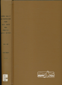
Book, Yarra Valley Metropolitan Park - Base Data and Analysis - Draft Report - Vol. III -Appendix 1997, 1977
... Yarra Valley Metropolitan Park - Base Data and Analysis..., development plan for proposed Yarra Valley Metropolitan Park... melbourne Book Yarra Valley Metropolitan Park - Base Data ...Data collection and analysis, concept and policy planning, development plan for proposed Yarra Valley Metropolitan Park30 cm -
Whitehorse Historical Society Inc.
Mixed media - Audio Cassette, Talk - Water in the Eastern Suburbs, 12/04/2003
... Yarra Valley Water... Yarra Valley Water on the 'History of the Provision of Water... Yarra Valley Water on the 'History of the Provision of Water... from Yarra Valley Water on the 'History of the Provision ...Cassette of a talk to the Society by David Elliott from Yarra Valley Water on the 'History of the Provision of Water in the Eastern Suburbs' on 12 April 2003.Cassette of a talk to the Society by David Elliott from Yarra Valley Water on the 'History of the Provision of Water in the Eastern Suburbs' on 12 April 2003.elliott, david, yarra valley water, water, nunawading & district historical society -
 Greensborough Historical Society
Bottle and Apron, Primary Edge Promotions, Medhurst Bottle and Apron, 2016_
... medhurst wines yarra valley...Medhurst Wines operates in Gruyere, Yarra Valley...Labelled Medhurst Chardonnay 2016 Yarra Valley; with, black... Medhurst Chardonnay 2016 Yarra Valley; with, black poly cotton ...Medhurst Wines operates in Gruyere, Yarra Valley. The winery is on land once owned by David Medhurst, formerly of Greensborough. These items were a gift to David's descendant, Faye Fort (nee Partington).Clear glass wine bottle 750 ml, screw cap, in black cardboard presentation box in red and white gift bagLabelled Medhurst Chardonnay 2016 Yarra Valley; with, black poly cotton apron, with pocket, embroidered Medhurst in white.medhurst family, medhurst wines yarra valley -
 Kew Historical Society Inc
Photograph - Yarra in Flood, 1934
... yarra valley...Flooding of the Yarra Valley, including that section...Black and white print positive. 1934 floods of the Yarra... floods of the Yarra Valley. Location Fairfield looking towards ...Flooding of the Yarra Valley, including that section of the Yarra bordering Kew and Kew East in the north and west of the municipality, was a regular occurrence. Extreme flood events of the Yarra River are recorded to have occurred in 1891, 1901, 1916, 1923 and 1934. The Municipality of Kew's response to these floods was to enact planning decisions restricting residential development in flood prone areas following the floods of 1916, 1921 and 1934. While floods continued after the development of the Upper Yarra Reservoir (construction 1948-57), the regularity and extent of these inundations diminished.Black and white print positive. 1934 floods of the Yarra Valley. Location Fairfield looking towards wooded hillside. Houses floating in river.Reverse: "From Fairfield Park (11936?) back towards hill (Wurundjeri Spur?)"floods -- 1934, yarra valley, yarra river, fairfield park -
 Eltham District Historical Society Inc
Work on paper (item) - Newspaper, Joseph Dubois, Yarra Valley Historical: a brief look at early life in the Valley during the mid 1800's to the 1900's
... Yarra Valley Historical: a brief look at early life in the... Valley. "Welcome to the fist edition of the Yarra Valley... melbourne Newspaper Work on paper Yarra Valley Historical: a brief ...Volume 1, Issue 1. Early History of the Upper and Yarra Valley. "Welcome to the fist edition of the Yarra Valley historical, the aim of this newspaper is to remind us of the men and women who came here to mine, farm or harvest the plentiful and tall timbers, that built towns and cities..." Estimated date of publication 2010. The newspaper is full of potted histories of places with historical photographs, maps and timelines. Acknowledgment and citations for source material given. Advertisements for business's at the time of publicaion. Lilydale, De Castella family, p2. Mount Evelyn p6. Wandin [Anker family] p7. Seville [William Henry Smith; Mr and Mrs Thomas Payne; Duck family; Chandler family] p8. Woori Yallock p10. Yellingbo p11. Hoddles Creek p12. Launching Place p13. Yarra Junction p14. Reminiscences of Don 'Ripper' Reid p18. Wesburn p20. Warburton Village Settlement p22. Warburton p23. Big Pats Creek p26. McMahons Creek / Reefton [Brimbonga School] p27. Gladysdale / Gilderoy [Saxton family] p28. Powelltown p30.lilydale, mt evelyn, wandin, seville, woori yallock, yellingbo, hoddles creek, launching place, yarra junction, don reid, reminiscences, wesburn, warburton, big pats creek, mcmahons creek, reefton, gladysdale, gilderoy, powelltown, newspaper -
 Lilydale RSL Sub Branch
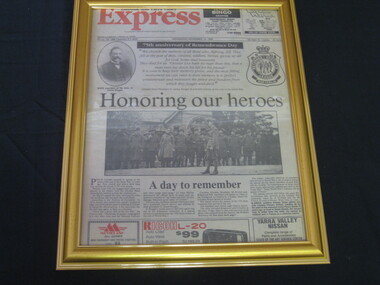
Newspaper - Framed front page of Lilydale and Yarra Valley Express, Honouring our heroes
... Framed front page of Lilydale and Yarra Valley Express... and Yarra Valley Express Newspaper Honouring our heroes Front page ...Front page of local paper on 75th Anniversary of Remembrance day - Wednesday November 10 1993. -
 Ringwood RSL Sub-Branch
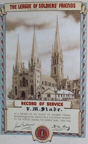
Work on paper - The league of soldiers friends , Yarra Valley Historical newspaper, newspaper articles
... The league of soldiers friends , Yarra Valley Historical... melbourne The league of soldiers friends , Yarra Valley Historical ...newspaper and certificae -
 Marysville & District Historical Society
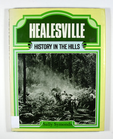
Book, Healesville-History in the Hills, 1982
... upper yarra valley...North Road, Lilydale, Yarra Valley, Victoria, Australia... Marysville yarra-valley-and-the-dandenong-ranges Book Book ...A history of HealesvilleHardcover. Front cover of dust jacket has a photograph of a bullock team hauling a load of timber. Back cover of dust jacket has a photograph of the Maroondah Dam.Stamp of the Marysville & District Historical Society Inc / P.O. Box 22 / Marysville 3779 R. Whitford For/ MANDY/ whose love of the bush/ brought us to Healesvillehealesville, upper yarra valley, victoria, australia, sally symonds, history -
 Kew Historical Society Inc
Clothing - Richmond-Brunswick Powerline Campaign tee-shirt, 1984-88
... , yarra valley, jill o'brien...The campaign to save the Yarra Valley from powerlines... to save the Yarra Valley from a proposal to build a massive power... The campaign to save the Yarra Valley from powerlines was a significant ...The campaign to save the Yarra Valley from powerlines was a significant environmental campaign in multiple suburbs in the 1980s.White tee-shirt with an image of a man being electrocuted which was produced and sold to raise funds for the campaign to save the Yarra Valley from a proposal to build a massive power line between Richmond and Brunswick. The black and white cartoon printed on the front of the tee-shirt is a cartoon by Jeff. The tee-shirt was donated to the Kew Historical Society by Jill O'Brien, ex councillor and Mayor of the former City of Kew, who was one of the leaders of the campaign.RICHMOND-BRUNSWICK POWER LINErichmond-brunswick powerline, community campaigns - 1980s, yarra valley, jill o'brien -
 Melbourne Tram Museum
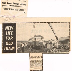
Newspaper, Lilydale and Yarra Valley Express, "New life for old tram", 11/08/1981 12:00:00 AM
... Newspaper cutting from the Lilydale and Yarra Valley...Lilydale and Yarra Valley Express... corner. Newspaper cutting from the Lilydale and Yarra Valley ...Newspaper cutting from the Lilydale and Yarra Valley Express 11-8-1981 - "New life for old tram" about the acquisition of off loading of W2 227 at the Phil McDonald's brickworks in Melba Ave Lilydale. See also Reg item 1644 for an item about its derailment in Footscray on 3/8/1981, but the tramcar cards show that the tram was withdrawn and sold during July 1981. Cutting has the Aust. Press Cuttings Agency source sheet pasted to the top left hand corner along with the paper name and date stamp.In pencil "Ballarat Trams" in top left hand corner.trams, tramways, tram disposal, scrapped trams, sale of trams, w2 class, tram 227 -
 Greensborough Historical Society
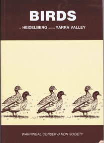
Book, Birds of Heidelberg and the Yarra Valley, 1981_
... Birds of Heidelberg and the Yarra Valley... and the Yarra Valley 115 p. paperback, buff-coloured paper, brown text ...Bird lists and locations in the Heidelberg area115 p. paperback, buff-coloured paper, brown text and illustrations.native fauna, heidelberg, birds -
 Greensborough Historical Society
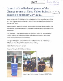
Document - Article, Rosie Bray, Launch of the redevelopment of the change rooms at Yarra Valley Swim School, 26/02/2021
... Launch of the redevelopment of the change rooms at Yarra... of the redevelopment of the change rooms at Yarra Valley Swim School 1 p.. two ...Opening of the renovated change rooms at the Yarra Swim School, February 26th 20211 p.. two colour photographs, with separate prints of photographsyarra swim school, swimming pools greensborough -
 Greensborough Historical Society
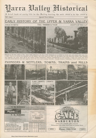
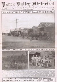
Newspaper, Mont de Lancey Historical Home and Museum, Yarra Valley Historical: Vol.1. Issue 4, 1866o
... Yarra Valley Historical: Vol.1. Issue 4.... Plenty Lower Plenty melbourne Newspaper Yarra Valley Historical ...A history of settlement of the Wandin Yalloak district from 1866, includes pioneer families and events. A publication of the Mont de Lancey Historical Home and Museum in Wandin.Newspaper, 32 pages, illus."Early History of Wandin Yalloak & District" on cover.wandin, mont de lancey historical home and museum -
 Marysville & District Historical Society
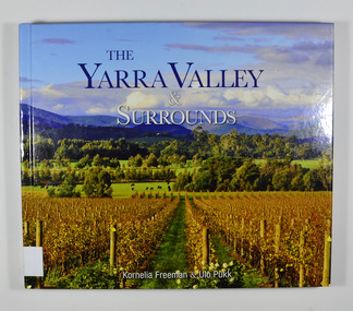
Book, The Yarra Valley & Surrounds, 2012
... The Yarra Valley & Surrounds... Marysville yarra-valley-and-the-dandenong-ranges Book Book The Yarra ...Hardcover. Front cover has a photograph of a winery surrounded by hills.Stamp of Marysville & District / Historical Society Inc / P.O. Box 22 / Marysville 3779victoria, australia, history, travel, pictorial works