Showing 7 items matching "yarra river -- billabongs"
-
 Kew Historical Society Inc
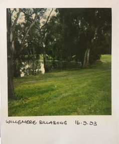
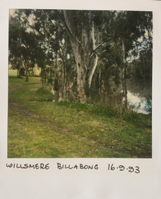
Photograph - Willsmere [Kew] Billabong, 1993
... billabong...willsmere park...yarra river...Yarra that there is any remnant native vegetation. Willsmere Park is of significance as an area of open land that remains from the flood plain that once dominated northern Kew. (Source: Kew Conservation Study, 1988) kew billabong willsmere park yarra river ...Willsmere Park is bounded by the the Yarra River, Green Acres Golf Club, Willow Grove and the Eastern Freeway. The land on which the park is now situated was bought by Thomas Wills at the Crown Land Sales of 1846 (Section 56). From the 1840s to the 1940s it was intensively farmed. The park is dominated by very large playing fields, while planting to the southern boundary was undertaken when the Eastern Freeway was built. It is only along the banks of the Yarra that there is any remnant native vegetation. Willsmere Park is of significance as an area of open land that remains from the flood plain that once dominated northern Kew. (Source: Kew Conservation Study, 1988)Original colour small format polaroid photograph of the 'Kew Billabong' in the Willsmere Park, taken on 16 September 1993."Willsmere Billabong 16.9.93"kew billabong, willsmere park, yarra river -- billabongs -
 Kew Historical Society Inc
Archive (Sub-series) - Subject File, Billabong - Willsmere Park, 1958
... billabong - willsmere park - kew east...billabongs - yarra river...Typically files will contain primary and secondary sources. billabong - willsmere park - kew east billabongs - yarra river Newspaper articles/clippings relating to the desire to save the Billabong at Willsmere Park in Kew. ...Various partiesReference, Research, InformationKHS OrderNewspaper articles/clippings relating to the desire to save the Billabong at Willsmere Park in Kew. The file includes articles with a more general focus relating to bike paths and Willsmere Park generally.billabong - willsmere park - kew east, billabongs - yarra riverbillabong - willsmere park - kew east, billabongs - yarra river -
 Kew Historical Society Inc
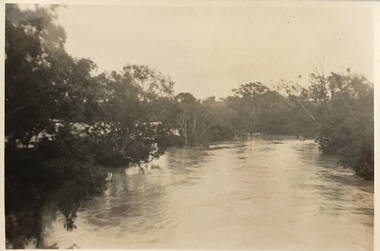
Photograph, Floods in North Kew, 1934
... Numerous photographs record flooding throughout the Twentieth Century. floods (kew) 1934 yarra river Floods in North Kew, 1934. Flood near the lagoon (Billabong?) Floods in North Kew Photograph Photograph ...Living with natural processes was frequently a challenge to early European settlers and later residents of what was in the 1850s administered by the Borondara Road Board. This was compounded by the area being bounded on three sides by rivers (Yarra River, Koonung Creek and Gardiner's Creek). In 1849, the historian James Bonwick recorded that "our district [Kew] suffered considerably. Mr Wade speaks of 80 acres, out of 100 acres of his cultivated paddock, covered by water." Newspapers continued to describe major flooding in Kew in 1863, 1869, 1878, 1880, 1889, 1891, 1916 and 1934. While the construction of the Upper Yarra dam in 1957 reduced the levels of flowing downstream, local and riverine floods continue.The Kew Historical Society's pictures and map collections testify to the impact of flooding in the district. They have historical importance in documenting the extent of flooding in the district and its affects on homes, services and recreation. Numerous photographs record flooding throughout the Twentieth Century.Floods in North Kew, 1934. Flood near the lagoon (Billabong?)floods (kew) 1934, yarra river -
 Kew Historical Society Inc
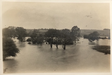
Photograph, Floods in North Kew, 1934
... Locally significant photographs of the impact of flooding in Kew in 1934 floods (kew) 1934 yarra river Floods in North Kew, 1934. Flood near Lagoon (Billabong?) Willsmere Road, North Kew. ...The great flood of 1934 in Melbourne was one of the most devastating floods since records began. The floods affected all of Melbourne, including Kew.Locally significant photographs of the impact of flooding in Kew in 1934Floods in North Kew, 1934. Flood near Lagoon (Billabong?) Willsmere Road, North Kew.floods (kew) 1934, yarra river -
 Kew Historical Society Inc
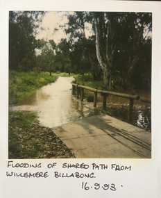
Photograph - Flooding in the Willsmere Park, 1993
... yarra river -- floods -- kew (vic.)...kew billabong...(Source: Kew Conservation Study, 1988) willsmere park yarra river -- floods -- kew (vic.) kew billabong "Flooding of shared path from Willsmere Billabong 16.9.93" Original colour small format polaroid photograph of flooding in the Willsmere Park, taken on 16 September 1993. ...Willsmere Park is bounded by the the Yarra River, Green Acres Golf Club, Willow Grove and the Eastern Freeway. The land on which the park is now situated was bought by Thomas Wills at the Crown Land Sales of 1846 (Section 56). From the 1840s to the 1940s it was intensively farmed. The park is dominated by very large playing fields, while planting to the southern boundary was undertaken when the Eastern Freeway was built. It is only along the banks of the Yarra that there is any remnant native vegetation. Willsmere Park is of significance as an area of open land that remains from the flood plain that once dominated northern Kew. (Source: Kew Conservation Study, 1988)Original colour small format polaroid photograph of flooding in the Willsmere Park, taken on 16 September 1993."Flooding of shared path from Willsmere Billabong 16.9.93"willsmere park, yarra river -- floods -- kew (vic.), kew billabong -
 Kew Historical Society Inc
Photograph - Willsmere [Kew] Billabong, 1993
... (Source: Kew Conservation Study, 1988) yarra river -- floods -- kew (vic.) willsmere park "Willsmere Billabong 16.9.93" Original colour small format polaroid photograph of Willsmere [Kew] Billabong on September 1993. ...Willsmere Park is bounded by the the Yarra River, Green Acres Golf Club, Willow Grove and the Eastern Freeway. The land on which the park is now situated was bought by Thomas Wills at the Crown Land Sales of 1846 (Section 56). From the 1840s to the 1940s it was intensively farmed. The park is dominated by very large playing fields, while planting to the southern boundary was undertaken when the Eastern Freeway was built. It is only along the banks of the Yarra that there is any remnant native vegetation. Willsmere Park is of significance as an area of open land that remains from the flood plain that once dominated northern Kew. (Source: Kew Conservation Study, 1988)Original colour small format polaroid photograph of Willsmere [Kew] Billabong on September 1993."Willsmere Billabong 16.9.93"yarra river -- floods -- kew (vic.), willsmere park -
 Bendigo Historical Society Inc.
Postcard - Elliot Postcard Collection: Australia, 1895 - 1914
... River Yarra 1405.328 A Settler's Hut 1405.329 Australian Bush 1405.330 Back Beach. Phillip Island - The Nobbies 1405.331 Train Crossing Bridge, Belgrave 1405.332 Town Hall, Melbourne 1405.333 Loretto Abbey, Mary's Mount, Ballarat 1405.334 Town of Tolmie 1405.335 Sandringham Baths 1405.336 A Billabong 1405.337 Lake Tyers, Gippsland, Victoria 1405.338 Entrance to Botannical Gardens, Ballarat, Vic 1405.339 The Last of the Portland 1405.340 River Scene...River Yarra 1405.328 A Settler's Hut 1405.329 Australian Bush 1405.330 Back Beach. Phillip Island - The Nobbies 1405.331 Train Crossing Bridge, Belgrave 1405.332 Town Hall, Melbourne 1405.333 Loretto Abbey, Mary's Mount, Ballarat 1405.334 Town of Tolmie 1405.335 Sandringham Baths 1405.336 A Billabong 1405.337 Lake Tyers, Gippsland, Victoria 1405.338 Entrance to Botannical Gardens, Ballarat, Vic 1405.339 The Last of the Portland 1405.340 River Scene Postcard Elliot Postcard Collection: Australia ...Thought to have originated in Austria in 1869, postcards first gained popularity in Australia in the 1890s.They were used to send short messages to friends and family. This collection was generated by Mary Emma Elliot of Talgarno. Talgarno is a rural locality in Victoria, Australia, situated on the southern shoreline of Lake Hume, about 23 km east of Albury-Wodonga. The collection contains postcards from across the world. Mary Emma Sibley was born in Ironbark, Bendigo in 1859. She married James Elliot in 1893 and they settled at “Kelso”, Talgarno. They had two children – Mona and Sibley. Mary Emma Elliot died in Melbourne in 1944, aged 84 years. Australian postcards collected by Mrs. James Elliot between 1898 and 1915. 1405.321 Collins Street, Melbourne 1405.322 The Badger River, Healesville 1405.323 City Hall, Ballarat, Australia 1405.324 River Scene, Warburton 1405.325 Kyabram Water Supply Tower 1405.326 Australian Pastoral Life 1405.327 River Yarra 1405.328 A Settler's Hut 1405.329 Australian Bush 1405.330 Back Beach. Phillip Island - The Nobbies 1405.331 Train Crossing Bridge, Belgrave 1405.332 Town Hall, Melbourne 1405.333 Loretto Abbey, Mary's Mount, Ballarat 1405.334 Town of Tolmie 1405.335 Sandringham Baths 1405.336 A Billabong 1405.337 Lake Tyers, Gippsland, Victoria 1405.338 Entrance to Botannical Gardens, Ballarat, Vic 1405.339 The Last of the Portland 1405.340 River Scenepostcards, collecting, collections, talgarno