Showing 521 items matching "yarra river valley"
-
 Kew Historical Society Inc
Book, Francis Jordan, Guide to historical resources of the Yarra Valley, focusing on conservation and historic landscape, 1992
... conservation of natural resources -- victoria -- yarra river valley...Reference books have entered the collection through donation, presentation, collection and purchase. conservation of natural resources -- victoria -- yarra river valley landscape -- victoria -- yarra river valley -- history ecology -- victoria -- yarra river valley historic sites -- victoria -- yarra river valley yarra river valley (vic.) -- history. ...[Ormond, Vic. : F.I. Jordan], 1991 31 leaves : 1 map ; 30 cm. non-fictionconservation of natural resources -- victoria -- yarra river valley, landscape -- victoria -- yarra river valley -- history, ecology -- victoria -- yarra river valley, historic sites -- victoria -- yarra river valley, yarra river valley (vic.) -- history. -
Koorie Heritage Trust
Booklet, Beardsell, David et al, The Yarra : a natural treasure, 1999
... Ecology -- Victoria -- Yarra River Valley. | Habitat (Ecology) -- Victoria -- Yarra River Valley...Koorie Heritage Trust Levels 1 & 3, Yarra Building Federation Square, Melbourne melbourne Ecology -- Victoria -- Yarra River Valley. | Habitat (Ecology) -- Victoria -- Yarra River Valley. | Zoology -- Victoria -- Yarra River Valley. ...Discusses the variations of the Yarra River over the years, its plant and animal life.x, 66 p. : ill., maps ; 21 cm.Discusses the variations of the Yarra River over the years, its plant and animal life.ecology -- victoria -- yarra river valley. | habitat (ecology) -- victoria -- yarra river valley. | zoology -- victoria -- yarra river valley. -
 Eltham District Historical Society Inc
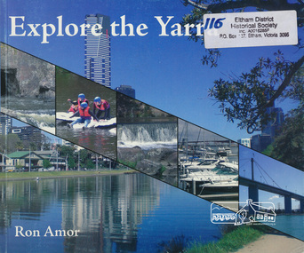
Book, Ron Amor, Explore the Yarra / Ron Amor, 2009
... yarra river...yarra river valley...Eltham District Historical Society Inc 728 Main Rd Eltham melbourne yarra river yarra river valley ISBN 9780980308525 Paperback; 101 p. : ill. ; 21 x 25 cm. ...Paperback; 101 p. : ill. ; 21 x 25 cm.ISBN 9780980308525yarra river, yarra river valley -
 Eltham District Historical Society Inc
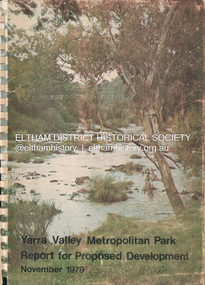
Book, Melbourne Metropolitan Board of Works, Yarra Valley Metropolitan Park : report for proposed development : a recreation, conservation and landscape planning study for the Melbourne and Metropolitan Board of Works, Metropolitan Parks Division / by Scott and Furphy Engineers Pty Ltd, Landscape Division, November 1979
... Yarra River...Yarra River Valley...Their final report is published bearing in mind that the development of the Yarra Valley Metropolitan Park must occur over a long span of time. Melbourne Metropolitan Board of Works Yarra River Yarra River Valley Yarra Valley Metropolitan Park A4 x 2cm Spiral bound ix, 252 pages : illustrations, maps ; 30 cm. ...In August 1976, MMBW commissioned Consultants to provide comprehensive planning services for the preparation of a Plan for the development of the Yarra Valley Metropolitan Park, the proposed Park is a linear corridor surrounded by the Heidelberg and Eltham communities to the north; the Camberwell, Doncaster and Templestowe and Warrandyte communities are located to the south. Parklands comprise about 1700 hectares or about 4200 acres of land extending from Burke Road Bridge to Pound Bend, Warrandyte. The consultants (Scott and Furphy Engineers Pty Ltd, Landscape Division) were directed to investigate all recreation, conservation and landscape aspects which would have direct visual, environmental or regional recreation bearing on the proposed parkland. Their final report is published bearing in mind that the development of the Yarra Valley Metropolitan Park must occur over a long span of time. melbourne metropolitan board of works, yarra river, yarra river valley, yarra valley metropolitan park -
 Eltham District Historical Society Inc
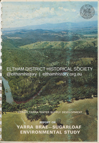
Book, Melbourne Metropolitan Board of Works, Lower Yarra Water Supply DeVelopment: Report on Yarra Brae-Sugarloaf Environmental Study, April 1974
... ...Yarra River Valley...Eltham District Historical Society Inc 728 Main Rd Eltham melbourne Environmental Study Melbourne Metropolitan Board of Works Report Sugarloaf Reservoir water catchment area water supply Yarra Brae Dam Yarra River Valley A4 x 3cm Spiral bound 1 v. (various paging) : ill. ...environmental study, melbourne metropolitan board of works, report, sugarloaf reservoir, water catchment area, water supply, yarra brae dam, yarra river valley -
 Eltham District Historical Society Inc
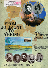
Book, Raymond Henderson, From Jolimont to Yering and along our Yarra valleys with Neuchatel's bachelor vignerons / Raymond Henderson, 2006c
... yarra river valley...Eltham District Historical Society Inc 728 Main Rd Eltham melbourne yarra river valley wine making vineyards ISBN 0958135851 Hardback with dust jacket; 426 p. : ill. ...Hardback with dust jacket; 426 p. : ill. (some col.), geneal. tables, maps, ports. ; 31 cm.ISBN 0958135851yarra river valley, wine making, vineyards -
 Kew Historical Society Inc
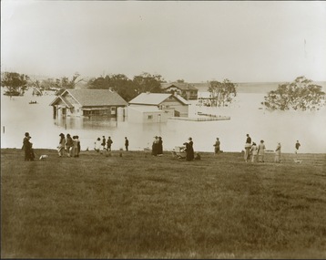
Photograph - Yarra in Flood from Willsmere, North Kew, 1923
... yarra river valley...Flooding of the Yarra Valley, including that section of the Yarra bordering Kew and Kew East in the north and west of the municipality, was a regular occurrence. Extreme flood events of the Yarra River...While floods continued after the development of the Upper Yarra Reservoir (construction 1948-57), the regularity and extent of these inundations diminished. yarra river valley Kew East (vic.) floods willsmere Inscribed reverse: "Gift of Kerrie Woollard (KCC) (P)C.1923 Original, large sepia photograph showing men, women and children who have gathered on a grassy verge, probably farm land, to look out across the flooded Yarra Valley at Willsmere, North Kew. ...Flooding of the Yarra Valley, including that section of the Yarra bordering Kew and Kew East in the north and west of the municipality, was a regular occurrence. Extreme flood events of the Yarra River are recorded to have occurred in 1891, 1901, 1916, 1923 and 1934. The Municipality of Kew's response to these floods was to enact planning decisions restricting residential development in flood prone areas following the floods of 1916, 1921, and 1934. While floods continued after the development of the Upper Yarra Reservoir (construction 1948-57), the regularity and extent of these inundations diminished. Original, large sepia photograph showing men, women and children who have gathered on a grassy verge, probably farm land, to look out across the flooded Yarra Valley at Willsmere, North Kew. In the medium distance are three houses that are largely submerged by the flood waters as well as a number of Eucalypts. Inscribed reverse: "Gift of Kerrie Woollard (KCC) (P)C.1923yarra river valley, kew east (vic.), floods, willsmere -
 Kew Historical Society Inc
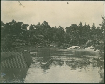
Photograph - Yarra Valley Floods: Kew East, 1916
... yarra river...yarra valley...Flooding of the Yarra Valley, including that section of the Yarra bordering Kew and Kew East in the north and west of the municipality, was a regular occurrence. Extreme flood events of the Yarra River...Yarra in Kew was devoted to dairy farming. In the twentieth century, before and after the construction of the Eastern Freeway, much of this low-lying area was used as golf courses and public parks. One of a collection of photographs of flooding in the Kew section of the Yarra Valley which are in important research resource for the location and extent of flooding in the first half of the twentieth century. yarra river yarra valley floods -- kew kilby road -- kew (vic.) kew golf club Verso: "Floods along Kilby Road / near Birdwood St? ...Flooding of the Yarra Valley, including that section of the Yarra bordering Kew and Kew East in the north and west of the municipality, was a regular occurrence. Extreme flood events of the Yarra River are recorded to have occurred in 1891, 1901, 1916, 1923 and 1934. The Municipality of Kew's response to these floods was to enact planning decisions restricting residential development in flood prone areas following the floods of 1916, 1921 and 1934. While floods continued after the development of the Upper Yarra Reservoir (construction 1948-57), the regularity and extent of these inundations diminished. During the nineteenth century, the land abutting the south side of the Yarra in Kew was devoted to dairy farming. In the twentieth century, before and after the construction of the Eastern Freeway, much of this low-lying area was used as golf courses and public parks.One of a collection of photographs of flooding in the Kew section of the Yarra Valley which are in important research resource for the location and extent of flooding in the first half of the twentieth century. Flooding of the Yarra Valley at East Kew in 1916. The view is taken from the intersection of Kilby Road with what is believed to be Birdwood Street, looking across the flood waters to Ivanhoe. The extensive flooded area shown in the photograph would have included the Kew Golf Club. Verso: "Floods along Kilby Road / near Birdwood St? & Kilby Road / 1917? / 87yarra river, yarra valley, floods -- kew, kilby road -- kew (vic.), kew golf club -
 Kew Historical Society Inc
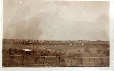
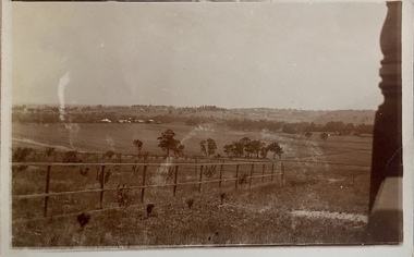
Photograph - Yarra Valley at Kew, 1918
... yarra river...yarra valley...In the twentieth century, before and after the construction of the Eastern Freeway, much of this low-lying area was used as golf courses and public parks. yarra river yarra valley Verso: "Willsmere / East Kew? ...During the nineteenth century, the land abutting the south side of the Yarra in Kew was devoted to dairy farming. In the twentieth century, before and after the construction of the Eastern Freeway, much of this low-lying area was used as golf courses and public parks.View of the farmland in the Yarra Valley at what is believed to be East Kew in 1918. Verso: "Willsmere / East Kew? / 1918"yarra river, yarra valley -
 Kew Historical Society Inc
Photograph - Yarra Valley Floods: Kew East, 1916
... yarra river...yarra valley...Flooding of the Yarra Valley, including that section of the Yarra bordering Kew and Kew East in the north and west of the municipality, was a regular occurrence. Extreme flood events of the Yarra River...Yarra in Kew was devoted to dairy farming. In the twentieth century, before and after the construction of the Eastern Freeway, much of this low-lying area was used as golf courses and public parks. One of a collection of photographs of flooding in the Kew section of the Yarra Valley which are in important research resource for the location and extent of flooding in the first half of the twentieth century. yarra river yarra valley floods -- kew kilby road -- kew (vic.) kew golf club Verso: "Floods / Yarra River / East Kew / Kilby Road / 1917? ...Flooding of the Yarra Valley, including that section of the Yarra bordering Kew and Kew East in the north and west of the municipality, was a regular occurrence. Extreme flood events of the Yarra River are recorded to have occurred in 1891, 1901, 1916, 1923 and 1934. The Municipality of Kew's response to these floods was to enact planning decisions restricting residential development in flood prone areas following the floods of 1916, 1921 and 1934. While floods continued after the development of the Upper Yarra Reservoir (construction 1948-57), the regularity and extent of these inundations diminished. During the nineteenth century, the land abutting the south side of the Yarra in Kew was devoted to dairy farming. In the twentieth century, before and after the construction of the Eastern Freeway, much of this low-lying area was used as golf courses and public parks.One of a collection of photographs of flooding in the Kew section of the Yarra Valley which are in important research resource for the location and extent of flooding in the first half of the twentieth century. Flooding of the Yarra Valley at East Kew in 1916. The view is taken from a street (maybe Birdwood Avenue) intersecting with Kilby Road looking northeast across the flood waters to Ivanhoe and Heidelberg. The extensive flooded area shown in the photograph would have included remnant dairy farms and the Kew Golf Club. Verso: "Floods / Yarra River / East Kew / Kilby Road / 1917? / 87"yarra river, yarra valley, floods -- kew, kilby road -- kew (vic.), kew golf club -
 Kew Historical Society Inc
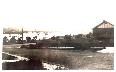
Photograph - Yarra Valley at Kew, 1912
... yarra river...yarra valley...In the twentieth century, before and after the construction of the Eastern Freeway, much of this low-lying area was used as golf courses and public parks. yarra river yarra valley farming -- kew (vic.) Verso: "Willsmere / East Kew / 1912" Real-photo postcard of the farmland in the Yarra Valley in what is believed to be North Kew in 1912. ...During the nineteenth century, the land abutting the south side of the Yarra in Kew was devoted to dairy farming. In the twentieth century, before and after the construction of the Eastern Freeway, much of this low-lying area was used as golf courses and public parks.Real-photo postcard of the farmland in the Yarra Valley in what is believed to be North Kew in 1912. Verso: "Willsmere / East Kew / 1912"yarra river, yarra valley, farming -- kew (vic.) -
 Kew Historical Society Inc
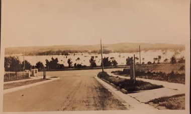
Photograph - Flood at Fairfield Park, 1934
... ...yarra valley...river...Flooding of the Yarra Valley, including that section of the Yarra bordering Kew and Kew East in the north and west of the municipality, was a regular occurrence. Extreme flood events of the Yarra River...While floods continued after the development of the Upper Yarra Reservoir (construction 1948-57), the regularity and extent of these inundations diminished. Fairfield park yarra valley river yarra floods -- 1934 Reverse: "Flood of Yarra at Fairfield Park 1934" Black and white print positive. ...Flooding of the Yarra Valley, including that section of the Yarra bordering Kew and Kew East in the north and west of the municipality, was a regular occurrence. Extreme flood events of the Yarra River are recorded to have occurred in 1891, 1901, 1916, 1923 and 1934. The Municipality of Kew's response to these floods was to enact planning decisions restricting residential development in flood prone areas following the floods of 1916, 1921 and 1934. While floods continued after the development of the Upper Yarra Reservoir (construction 1948-57), the regularity and extent of these inundations diminished.Black and white print positive. Yarra River at Fairfield in 1934. Major flood resulting in submerged buildings in middle ground and onlookers on far bankReverse: "Flood of Yarra at Fairfield Park 1934"fairfield park, yarra valley, river yarra, floods -- 1934 -
 Kew Historical Society Inc
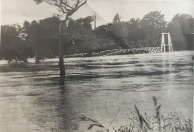
Photograph - Kane's Bridge destroyed by the 1934 Flood, 1934
... River Yarra...Yarra valley...The present form of the bridge resembles the earlier bridge which crossed from the Yarra Bend Asylum to Kew, further upstream. (VHD) kane's bridge River Yarra Yarra valley 1934 floods Annotation verso: "Kane's Bridge in 1934 flood / Dec. 1934. ...In 1928 a footbridge was erected to link Kew with the public golf course across the Yarra. The total cost of construction came to 250 pounds and the bridge became known as Kane's Bridge. During the 1934 floods the bridge was washed downstream, and was subsequently rebuilt. The present form of the bridge resembles the earlier bridge which crossed from the Yarra Bend Asylum to Kew, further upstream. (VHD)Black and white positive print (identical to 2021.70 but with a different annotation) showing the destruction of Kane's Bridge in the floods of 1934. The Kodak paper would indicate a 1950s reprinting.Annotation verso: "Kane's Bridge in 1934 flood / Dec. 1934.kane's bridge, river yarra, yarra valley, 1934 floods -
 Emerald Museum & Nobelius Heritage Park
Postcard - Postcard of Australian bush scene with A. B. Paterson lines, 1890s
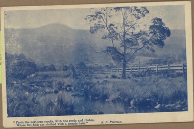
... yarra-valley-and-the-dandenong-ranges This postcard is part of an album of postcards which date from late 19th century to mid 20th century. It depicts a romanticized bush scene with two lines of A. B. Paterson poem, 'Black Swans', underneath. A. B. Paterson 1864-1941 was a famous Australian bush poet most notable for writing 'Waltzing Matilda' and 'The Man from Snowy River ...This postcard is part of an album of postcards which date from late 19th century to mid 20th century. It depicts a romanticized bush scene with two lines of A. B. Paterson poem, 'Black Swans', underneath. A. B. Paterson 1864-1941 was a famous Australian bush poet most notable for writing 'Waltzing Matilda' and 'The Man from Snowy River'. 'Black Swans' was first published in 1893. As this postcard is glued to the album, other information is unavailable, but this postcard is likely to have been printed in the late 19th or early 20th centuries.This postcard is in an album of postcards dating from the late 19th century to mid 20th century. It reflects the popularity of collecting postcards in Australia which reached a height in the early 1900s until around 1920. Postcard of Australian bush scene with two lines of A. B. Paterson poem, Black Swans, underneath picture. On front, printed underneath photograph: ' "From the northern creeks with the reeds and rushes, / Where the hills are clothed with a purple haze." / A. B. Paterson'postcard, photography, 1900s, buildings, beechworth, "green postcard album" -
 Emerald Museum & Nobelius Heritage Park
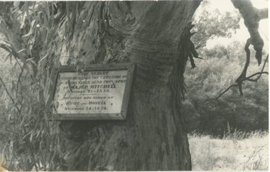
Photograph - Photograph of plaque commemorating Major Mitchell
... Emerald Museum & Nobelius Heritage Park 5 Crichton Rd Emerald yarra-valley-and-the-dandenong-ranges This plaque was unveiled on 23 April 1915 to commemorate early colonial explorers, Major Mitchell and before him, Hume and Hovell. These explorers crossed the Ovens River ...This plaque was unveiled on 23 April 1915 to commemorate early colonial explorers, Major Mitchell and before him, Hume and Hovell. These explorers crossed the Ovens River in 1824 and 1836. The plaque has now been replaced by a tablet. This photograph and other postcards and photographs came from the estate of David Moyle (1938-2015) who was a police officer in Emerald during late 1960s-early 1970s, and subsequently at Belgrave in the early 1980s. David Moyle was closely associated with the now defunct Sherbrooke Historical Association. This photograph is significant because it recalls the early history of Victorian colonial exploration and settlement and is emblematic of the importance placed by the local community on Major Mitchell's and Hume and Hovell's explorations. Also, this photograph is part of a collection belonging to a community member who had a close association with a local historical society.Photograph of plaque on tree commemorating Major Mitchell's crossing of the Ovens River (1836) in the footsteps of Hume and Hovell (1824). david moyle, police, emerald, belgrave, major mitchell, hume and hovell, ovens river, plaque -
 Emerald Museum & Nobelius Heritage Park
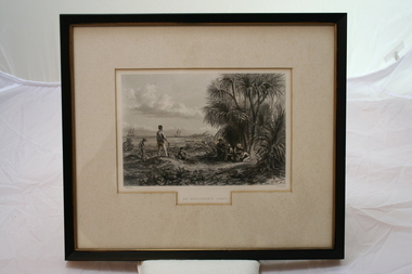
Relief prints, Thomas Baines et al, An Explorer's Camp, Circa 1875
... yarra-valley-and-the-dandenong-ranges From 'Australia' by Edwin Carton Booth. Thomas Baines joined Augustus Gregory as official artist and storekeeper, in the expedition across northern Australia between 1855-1857 sponsored by the Royal Geographical Society to evaluate the northern area of Australia for suitability as a colonial settlement. The Baines River ...From 'Australia' by Edwin Carton Booth. Thomas Baines joined Augustus Gregory as official artist and storekeeper, in the expedition across northern Australia between 1855-1857 sponsored by the Royal Geographical Society to evaluate the northern area of Australia for suitability as a colonial settlement. The Baines River was named after him.The item is socially and artistically significant as it is a very early image of Northern Australia.Framed black and white etching depicting a cap site located near the ocean.Artist T. Baines - J.J. Crew. From 'Australia' by Edwin Carton Booth. Thomas Baines joined Augustus Gregory as official artist and storekeeper, in the expedition across northern Australia between 1855-1857 sponsored by the Royal Geographical Society to evaluate the northern area of Australia for suitability as a colonial settlement. The Baines River was named after him.print, baines -
 Emerald Museum & Nobelius Heritage Park
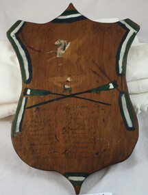
Award - Wooden shield commemorating rowing regatta wins
... Emerald Museum & Nobelius Heritage Park 5 Crichton Rd Emerald yarra-valley-and-the-dandenong-ranges This shield belonged to Dr Ian 'Spud' MacLeod Murphy (1905 - 1981) and was presumably awarded to him when he was the cox of the winning Geelong College team in the Head of the River competitions (rowing regattas) in 1921 and 1922. ...This shield belonged to Dr Ian 'Spud' MacLeod Murphy (1905 - 1981) and was presumably awarded to him when he was the cox of the winning Geelong College team in the Head of the River competitions (rowing regattas) in 1921 and 1922. He attended Geelong College 1919-1922 and later, Melbourne University (1929-1937). Dr Murphy retired to Emerald in 1947 intending to breed turkeys but instead responded to the community need for a GP. For the next 34 years, he was Emerald's GP working seven days a week without assistance and travelling all over the hills. He was awarded the British Empire Medal in 1977 for devotion to the health of the community. He died in 1981 at the age of 76 years and a Memorial Fund was set up in his name to provide support for local students studying Medicine.Dr Murphy was Emerald's first and much-loved GP. His work for the community over 34 years was of immense benefit to Emerald and surrounding districts. Wooden shield with green and white stripes painted around edges and green and white crossed oars in the centre. A partly torn off sticker of Pegasus (Greek mythological winged horse and motif of Geelong College) is above the crossed oars. On front below crossed oars is handwritten two lists of team members of winning teams of 1921 and 1922. On back handwritten 'Murphy'dr ian macleod murphy, spud murphy, doctor, emerald, geelong college -
 Marysville & District Historical Society
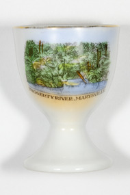
Souvenir - Egg cup, Taggerty River Marysville
... Marysville & District Historical Society 39 Darwin Street Marysville yarra-valley-and-the-dandenong-ranges Royal Scenic China Egg cup white with gold trim and an image and text of Taggerty River Marysville in front. ...Royal Scenic China Egg cup white with gold trim and an image and text of Taggerty River Marysville in front. Made in Bohemia. -
Marysville & District Historical Society
THE TRIANGLE NEWS-VOL 39 NO 26-JULY 13 2012
... Marysville & District Historical Society 39 Darwin Street Marysville yarra-valley-and-the-dandenong-ranges marysville victoria australia loan subsidies still on offer for marysville & triangle marysville & triangle investment subsidary for affected bushfire areas regional arts fund steel pan bands receiving funding for international festivals what's on when in july the committee of management of the gallipoli park precinct marysville community market creative triangle murrindindi shire council shire tennis club growth support alexandra junior soccer club advertisements vale stephen franzi-ford church notices parkinsons victoria ambassadors of hope marysville golf report goulburn river high country rail trail rising power and gas bills marysville pharmacy marysville medical clinic mayor's chair adventurous cooks marysville community golf & bowls club trivia and pasta intrepid triangle bushwalkers sample wines alexandra library midnight express dance taggerty hall alexandra cinema real estate council's rating review strategy yea council chambers lake mountain alpine resort ann thoma 1995 reflections on history marysville & district historical society national emergency medal nominations marysviile steel band festival 2013 THE TRIANGLE NEWS-VOL 39 NO 26-JULY 13 2012 ...marysville, victoria, australia, loan subsidies still on offer for marysville & triangle, marysville & triangle investment subsidary for affected bushfire areas, regional arts fund, steel pan bands receiving funding for international festivals, what's on when in july, the committee of management of the gallipoli park precinct, marysville community market, creative triangle, murrindindi shire council, shire tennis club growth support, alexandra junior soccer club, advertisements, vale stephen franzi-ford, church notices, parkinsons victoria ambassadors of hope, marysville golf report, goulburn river high country rail trail, rising power and gas bills, marysville pharmacy, marysville medical clinic, mayor's chair, adventurous cooks, marysville community golf & bowls club, trivia and pasta, intrepid triangle bushwalkers, sample wines, alexandra library, midnight express dance, taggerty hall, alexandra cinema, real estate, council's rating review strategy, yea council chambers, lake mountain alpine resort, ann thoma 1995 reflections on history, marysville & district historical society, national emergency medal nominations, marysviile steel band festival 2013 -
Marysville & District Historical Society
THE TRIANGLE NEWS-VOL 35 NO 6-FEBRUARY 23 2007
... Marysville & District Historical Society 39 Darwin Street Marysville yarra-valley-and-the-dandenong-ranges marysville victoria australia a special sunday in buxton buxton pub diary dates deadline advertising rates narbethong community & tourism group community consultation disclaimer fire calls murrindindi shire council ceo visiting schedule farewell val jefferys bohemian nights concert cafe concert series church notices mops marysville scottish country & english morris dancing group world day of prayer women of hope marysville medical clinic community health services outreach services mitchell community health barefoot bowls yea wetlands freshwater fish taggerty on little river wirreanda festival marysville & district cricket club triva night kooringa indoor bowling complex marysville golf report alexandra cinema hairdressers advertisements hw greenham & sons water restrictions 6th marysville reunion crossways cabaret cambarville sawmill commuity reunion youth disco advertisements anglican priest leaving marysville police news parks victoria advises fox control restaurant advertisements mayor's chair combined taggerty clearing sale health & wellbeing for sale public notices THE TRIANGLE NEWS-VOL 35 NO 6-FEBRUARY 23 2007 ...marysville, victoria, australia, a special sunday in buxton, buxton pub, diary dates, deadline, advertising rates, narbethong community & tourism group, community consultation, disclaimer, fire calls, murrindindi shire council, ceo visiting schedule, farewell val jefferys, bohemian nights concert, cafe concert series, church notices, mops, marysville scottish country & english morris dancing group, world day of prayer, women of hope, marysville medical clinic, community health services, outreach services, mitchell community health, barefoot bowls, yea wetlands, freshwater fish, taggerty on little river, wirreanda festival, marysville & district cricket club, triva night, kooringa indoor bowling complex, marysville golf report, alexandra cinema, hairdressers advertisements, hw greenham & sons, water restrictions, 6th marysville reunion, crossways cabaret, cambarville sawmill commuity reunion, youth disco, advertisements, anglican priest leaving, marysville police news, parks victoria advises, fox control, restaurant advertisements, mayor's chair, combined taggerty clearing sale, health & wellbeing, for sale, public notices -
Marysville & District Historical Society
THE TRIANGLE NEWS-VOL 37 NO 33-SEPTEMBER 10 2010
... Marysville & District Historical Society 39 Darwin Street Marysville yarra-valley-and-the-dandenong-ranges marysville victoria australia flooding taggerty and steavenson river buxton THE TRIANGLE NEWS-VOL 37 NO 33-SEPTEMBER 10 2010 ...marysville, victoria, australia, flooding, taggerty and steavenson river, buxton -
Marysville & District Historical Society
THE TRIANGLE NEWS-VOL 37 NO 36-OCTOBER 1 2010
... Marysville & District Historical Society 39 Darwin Street Marysville yarra-valley-and-the-dandenong-ranges marysville victoria australia national water week goulburn-murray water shepparton water treatment river to tap tour alexandra goulburn broken catchment donation to yea community murrindindi shire council THE TRIANGLE NEWS-VOL 37 NO 36-OCTOBER 1 2010 ...marysville, victoria, australia, national water week, goulburn-murray water, shepparton water treatment, river to tap tour alexandra, goulburn broken catchment, donation to yea community, murrindindi shire council -
Marysville & District Historical Society
THE TRIANGLE NEWS-VOL 39 NO 2-JANUARY 27 2012
... Marysville & District Historical Society 39 Darwin Street Marysville yarra-valley-and-the-dandenong-ranges marysville victoria australia goulburn river high country rail trail alexandra traders & tourism assocn yea business & tourism assocn poh from poh's kitchen lunch poh ling yeow marysville world's longest lunch foodworks murrindindi masters golf event heather jenkins wins golf trophy marysville medical clinic advertisements the 3 tenors show marysville community centre marysville & triangle christmas shopping bonanza alexandra council chamber THE TRIANGLE NEWS-VOL 39 NO 2-JANUARY 27 2012 ...marysville, victoria, australia, goulburn river high country rail trail, alexandra traders & tourism assocn, yea business & tourism assocn, poh from poh's kitchen lunch, poh ling yeow, marysville world's longest lunch, foodworks murrindindi masters golf event, heather jenkins wins golf trophy, marysville medical clinic, advertisements, the 3 tenors show, marysville community centre, marysville & triangle christmas shopping bonanza, alexandra council chamber -
 Upper Yarra Museum
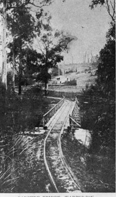
Negative Photographic Reproduction, Parbury Bridge Warburton, 14.2.1983
... Upper Yarra Museum Old Railway Station 2415C Warburton Highway Yarra Junction yarra-valley-and-dandenong-ranges parbury bridge warburton tramway yarra river Parbury Bridge Warburton Negative Black white. ...Parbury Bridge Warburton Negative Black white. Scanned at 600 dpi.parbury bridge warburton tramway yarra river -
 Upper Yarra Museum
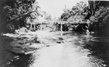
Negative Photographic Reproduction, Bridge over the Yarra
... Upper Yarra Museum Old Railway Station 2415C Warburton Highway Yarra Junction yarra-valley-and-dandenong-ranges bridge over yarra river 03050 Bridge over the Yarra. ...03050 Bridge over the Yarra. Upper Yarra Shire 1888-1988 Centenary collection. Black & white Negative, scanned at 600 dpibridge over yarra river -
 Upper Yarra Museum
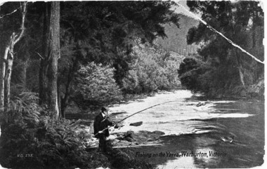
Negative Photographic Reproduction, PC Fishing on the Yarra River, Warburton
... Upper Yarra Museum Old Railway Station 2415C Warburton Highway Yarra Junction yarra-valley-and-dandenong-ranges pc fishing yarra river warburton Post Card Fishing on the Yarra River, Warburton Negative Black white Scanned at 600 dpi PC Fishing on the Yarra River, Warburton Negative Photographic Reproduction Sandy Ross ...Post Card Fishing on the Yarra River, Warburton Negative Black white Scanned at 600 dpipc fishing yarra river warburton -
 Eltham District Historical Society Inc
Film - Video (VHS), Nillumbik Shire Council, The Nillumbik Story, 1996
... Yarra River at Eltham at Eltham Lower Park. Highlights Eltham Lower Park community revegetation program and the newly constructed (1996) viewing platform built of new and recycled timbers at the confluence of the Diamond Creek and Yarra River. Also featured are outdoor recreation on the river and at Eltham Lower Park including the Diamond Valley...Yarra River at Eltham at Eltham Lower Park. Highlights Eltham Lower Park community revegetation program and the newly constructed (1996) viewing platform built of new and recycled timbers at the confluence of the Diamond Creek and Yarra River. Also featured are outdoor recreation on the river and at Eltham Lower Park including the Diamond Valley ...PART 1 – NILLUMBIK (00:00-07:17) Opening features various scenes around Nillumbik Shire. For 40,000 years Nillumbik was the home of the Wurundjeri people. Robert Hoddle gave the district its name. Jock Ryan, then president of Nillumbik Historical Society discusses the names Nillumbik and Diamond Creek. In the late 1830s white occupation began with gold found in Warrandyte in 1851 and 12 years later at Diamond Creek -the Diamond Reef which led to the Caledonian gold rush. Jock Ryan discusses the Diamond Creek mine, which was thriving until it burnt out in 1915. Large numbers of workmen moved into area in late 1870s to construct the Maroondah Aqueduct. With growing population of Melbourne, the nearby Yan Yean system had severely disrupted the flow of the Plenty River, forcing the closure of three flour mills there. The aqueduct came to the rescue carrying water 66km from Healesville to Preston. When the Diamond Creek gold mine burnt down the local economy suffered but fruit growing industry had already been established and Diamond Creek became a thriving fruit growing centre. Interview with Jack Powell, a long-time fruiterer at St Andrews market, his family had lived in the area for a hundred years, 3 to 4 generations, “a lot of hard work”. By the time the railway arrived fruit growing was no longer competitive. The railway brought the city closer and day trippers. The Green Wedge separates the shire from the more densely developed neighbours such as Whittlesea, Doncaster, Templestowe, Bulleen and Greensborough. Population at the time (1996) was 19,000 but links to the past remain strong. Mudbrick houses along the Heritage Trail The saving of Shillinglaw Cottage from demolition in 1963 and relocation brick by brick. PART 2 – ENVIRONMENT (07:18-14:44) Peter Brock (with Bev Brock in background) at St Andrews market discusses his childhood growing up in the district and the environment and the values it instilled upon him and his own family. The Brocks have been in the district since the 1860s. Nillumbik Shire responsible for managing three catchment areas; Diamond Creek, Arthurs Creek and Watsons Creek. Follows the course of the Diamond Creek commencing in Kinglake through the district to its confluence with the Yarra River at Eltham at Eltham Lower Park. Highlights Eltham Lower Park community revegetation program and the newly constructed (1996) viewing platform built of new and recycled timbers at the confluence of the Diamond Creek and Yarra River. Also featured are outdoor recreation on the river and at Eltham Lower Park including the Diamond Valley miniature railway. Sugarloaf reservoir and recreational activities and fishing. Aerial view of Memorial Park and Shire of Eltham War Memorial tower at Garden Hill, Kangaroo Ground. Significant tourism opportunities for the shire with 3 million potential day-trippers in metropolitan Melbourne. Council and community working together to find a way to promote the shires natural and artistic assets. At Arthurs Creek, the Brock family and neighbours working together to take care of their waterway. Peter Brock’s uncle, Sandy Brock talks about environmental management and the Arthurs Creek Landcare group and actions to eradicate blackberry problem. Having previously planted Cypress rows they are replacing them with indigenous species to improve the water supply, keeping cattle out of the creek bed to improve the quality downstream flowing into the Yarra. Eltham East Primary School Band playing “All things bright and beautiful” merges into scenes of the bushland sanctuary set aside by the school in 1980 with unidentified teacher discusses the sanctuary and their education program and school children’s comments. Plight of a family of Wedgetail eagles nesting in the path of a developer’s bulldozer at North Warrandyte and actions to save their nesting areas. PART 3 – ARTS (14:45-22:00) Arts and Jazz festival at Montsalvat featuring interviews with Sigmund Jorgensen discussing Montsalvat and its principles. Also Matcham Skipper. Clifton Pugh’s funeral at Montsalvat and his legacy at Dunmoochin near Cottlesbridge with artists in residence, at the time, Chicago artist Charles Reddington who discusses the benefits of the experience. An unidentified female artist also talks about the program and why people are drawn to the area. Unidentified man on street talking about the amount of talent in the area, artists, poets, musicians, authors. Artist Ming Mackay (1918-2009) interviewed talking about the people she mixes with on “the Hill”. Works of local artists are displayed Eltham Library Community Gallery and Wiregrass gallery with a new coffee shop at the Wiregrass making it an even more popular destination. Music at St Andrews Hotel (may be a little bit country) and the Saturday market where likely to hear anything. Sellers and patrons at the market asked about what attracts them to the market and where they came from. Scenes of poets/authors giving readings. CREDITS Music by John Greenfield from the CD Sweet Rain “The Snow Tree”, Uncle Music UNC 2001 Cameras - David Mirabella and Peter Farragher Editor – Olwyn Jones Written and Produced by Jason Cameron A Jason Cameron Proction for Nillumbik ShireProvides a record of the relatively newly created Shire of Nillumbik at the time and the features and attactions of the shire in its people arts, culture and environmentVHS Cassette (five copies) DVD (one copy) Converted to MP4 file format 0:22:00, 1.60GBvideo recording, arthurs creek, arthurs creek landcare group, artists, artists in residence, arts, arts festival, authors, blackberry, brock family, bulldozer, bulleen, bushland sanctuary, caledonian gold rush, charles reddington, clifton pugh, cottlesbridge, cypress rows, developer, diamond creek, diamond creek mine, diamond reef, diamond valley miniature railway, doncaster, dunmoochin, education program, eeps, eltham, eltham east primary school, eltham east primary school band, eltham library community gallery, eltham lower park, environment, fishing, flour mill, fruit growing, fruiterer, garden hill, gold mining, green wedge, greensborough, heritage trail, hurstbridge railway line, jazz festival, jock ryan, kangaroo ground, kangaroo ground tower, kinglake, maroondah aqueduct, matcham skipper, memorial park, ming mackay (1918-2009), montsalvat, mudbrick houses, music, musicians, nesting area, nillumbik historical society, nillumbik shire, north warrandyte, old timer, orchards, peter brock, plenty river, poets, population, recreation, recreational activities, revegetation, robert hoddle, sandy brock, shillinglaw cottage, shire of eltham war memorial, sigmund jorgensen, st andrews hotel, st andrews market, sugarloaf reservoir, templestowe, the hill, tourism, viewing platform, warrandyte, water catchment area, watsons creek, wedgetail eagle, whittlesea, wiregrass gallery, wurundjeri, yarra river, jack powell -
 Eltham District Historical Society Inc
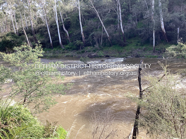
Photograph, Fay Bridge, Ancient Eel trap on the Yarra River at Laughing Waters, Eltham - pre-dating European settlement, 6 September 2023
... Laughing Waters is the name for a stretch of the Yarra Valley Parklands consisting of river flats and hilly riparian bushland. ...Eltham District Historical Society Inc 728 Main Rd Eltham melbourne Laughing Waters is the name for a stretch of the Yarra Valley Parklands consisting of river flats and hilly riparian bushland. ...Laughing Waters is the name for a stretch of the Yarra Valley Parklands consisting of river flats and hilly riparian bushland. With Birrarung (Yarra River) flowing through, Laughing Waters has been an important gathering place for thousands of years. For the Wurundjeri, ‘Garambi Baan’ (the name for Laughing Waters in Woi wurrung) is an important site for growing and harvesting food. Significantly, Wurundjeri iuk (eel) traps remain at Garambi Baan to this day. The Wurundjeri Woi Wurrung People take their name from the Woi wurrung language word ‘wurun’ meaning the Manna Gum (Eucalyptus viminalis) which is common along ‘Birrarung’ (Yarra River), and ‘djeri’, the grub which is found in or near the tree. Wurundjeri are the ‘Manna Gum People’ and their Ancestors have lived on this land for millennia. The site on the Yarra River near the former Morrison property Killeavey was given a language name in 2015 at the instigation of Wurundjeri Elder, Dave Wandin. Garambi Baan means “laughing waters” in the traditional language, Woi wurrung. The site at Warrandyte was rediscovered by Campbell Beardsell OAM in 2007 and is one of only a few known remaining iuk (eel) traps on Country once found the length of the Birrarung (Yarra) and the Maribyrnong. Original Indigenous aquacultural infrastructure was dismantled, taken away from sites and used to build houses, fords and roads by Europeans. The difficult and restricted access to this site is thought to be one of the reasons for its survival. The iuk trap is located within lands managed by Parks Victoria. The Narrap team in partnership with Parks Victoria and Acacia Land Management have been improving the native vegetation with a program of woody weed removal, exclusion fencing and revegetation. Importantly, the team have restored the trap’s infrastructure and have demonstrated its effectiveness.” References: Wurundjeri Woi Wurrung Cultural Heritage Aboriginal Corporation - Laughing Waters. (2023, September 3). Retrieved from https://inplace.org.au/laughing-waters/ GARAMBI BAAN LAUGHING WATERS RESIDENCY CENTRE 2020 2024 Strategic Plan, Nillumbik Shire Council (2023, September 3). Retrieved from https://www.nillumbik.vic.gov.au/files/assets/public/minutes-and-agendas/2020/09-sep/15-sep-cm/ocm.177-20-attachment-1-laughing-waters-arts-program_1.pdffay bridge collection, eel trap, laughing waters, yarra river, wurundjeri woi wurrung, garambi baan, 2023-09-06 -
Eltham District Historical Society Inc
Document - Folder, Newman, Charles
... Yarra River at Templestowe after serving in India in the East India Company. Later be married and moved to Tasmania, farming at Black Brush near Pontville. In 1835 he came to the Port Phillip District and explored the Yarra River, returning with his family. David Crockett and Hazel Poulter researched, respectively, Charles Newman and the Templestowe area, identifying the Newman house, Pontville, on the Yarra banks. David Crockett also researched James and Anne Anderson. Contents Newspaper article: "David fills in the gaps", Diamond Valley...Yarra River at Templestowe after serving in India in the East India Company. Later be married and moved to Tasmania, farming at Black Brush near Pontville. In 1835 he came to the Port Phillip District and explored the Yarra River, returning with his family. David Crockett and Hazel Poulter researched, respectively, Charles Newman and the Templestowe area, identifying the Newman house, Pontville, on the Yarra banks. David Crockett also researched James and Anne Anderson. Contents Newspaper article: "David fills in the gaps", Diamond Valley ...British army officer Major Charles Newman was an early settler on the Yarra River at Templestowe after serving in India in the East India Company. Later be married and moved to Tasmania, farming at Black Brush near Pontville. In 1835 he came to the Port Phillip District and explored the Yarra River, returning with his family. David Crockett and Hazel Poulter researched, respectively, Charles Newman and the Templestowe area, identifying the Newman house, Pontville, on the Yarra banks. David Crockett also researched James and Anne Anderson. Contents Newspaper article: "David fills in the gaps", Diamond Valley News, 16 December 1986.29 October 1985, p62. Story of Charles Newman and of David Crockett and Hazel Poulter's researches. Letter, A (Tony) B Owen to Eltham Historical Society, 12 March 2018, enclosing information about Major Charles Newman. Email, Eltham District Historical Society to Tony Owen, acknowledging receipt of information about Major Charles Newman. Photocopy of pages from "Glimpses of Life in Victoria", pp38-43. Flier, "Heritage Events in Nillumbik, 2005". Photocopy of pages from unidentified volume, chapter headed "The Bush", and part chapter IV "Bushrangers". Warrandyte Historical Society publication "The Wurundjeri Clan of the Kulin". Whitehorse Manningham Heritage Network search results for "Andersons Station on the Yarra Yarra", "A brief history of Warrandyte", "The branch is broken", "Melbourne's historic home", "Land with infamous past", "Charles Newman's original grave at Monckton", and "Site of Major Newman's land". Photocopy of pages from "Templestowe - a folk history", Hazel Poulter, 1985,: "The squatter, Major Charles Newman".Newspaper clippings, A4 photocopies, etccharles newman, british east india company, templestowe vic, warrandyte vic, david crockett, hazel poulter, james anderson, anne anderdon, a b owen, wurundjeri clan of the kulin, andersons station on the yarra river -
 Eltham District Historical Society Inc
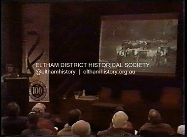
Film - Video (DVD), Melbourne and Metropolitan Board of Works, Yarra River Conference Proceedings; a Board of Works centenary event, 13-16 April 1991
... to Utility Early navigators of the Yarra River; developing the port of Melbourne; the gold rush and its effect on the new colony; punts and bridges; water supply; pollution of the Yarra; the discovery of gold and early settlement of the Yarra valley; floods of 1839 and 1863. 1863-1891 Formation of the Harbour Trust; Coode Canal; pollution of the Yarra by industry; aborigines, gold miners, timber getters in the Upper Yarra areas; bridges; the flood of 1891. ...to Utility Early navigators of the Yarra River; developing the port of Melbourne; the gold rush and its effect on the new colony; punts and bridges; water supply; pollution of the Yarra; the discovery of gold and early settlement of the Yarra valley; floods of 1839 and 1863. 1863-1891 Formation of the Harbour Trust; Coode Canal; pollution of the Yarra by industry; aborigines, gold miners, timber getters in the Upper Yarra areas; bridges; the flood of 1891. ...Yarra River Conference History Segment [Noted on VHS tape jackets "Due to unavoidable circumstances, the quality of these tapes in some setions is less than desired."] The Yarra River Conference, organised by the Board of Works as part of the Centenary Celebrations, was held in the Board's Head Office Theatrette from 13-16 April, 1991. A segment of the Conference focussed on the role that the Yarra River has played in relation to the historical development of Melbourne. Conceived and presented by a group of prominent historians as a chronological 'trip down the river in time', and profusely illustrated with slides, this segment traced the various impacts that urban and rural growth, development of marine commerce, recreational uses, and environmental problems have had on the Yarra during a century and a half of European occupation. As no formal written paper of this combined presentation is available, these two video-tapes provide a record for anyone who has an interest in tis fascinating aspect of the Yarra's history. The speakers who combined to present this segment are identified on the cover of Tape 2. Tape 1 (2 hours) 1838-1863 Deputy ?? to Utility Early navigators of the Yarra River; developing the port of Melbourne; the gold rush and its effect on the new colony; punts and bridges; water supply; pollution of the Yarra; the discovery of gold and early settlement of the Yarra valley; floods of 1839 and 1863. 1863-1891 Formation of the Harbour Trust; Coode Canal; pollution of the Yarra by industry; aborigines, gold miners, timber getters in the Upper Yarra areas; bridges; the flood of 1891. Tape 2 ( 1 1/2 hours) 1892-1934: People Begin to See Beauty and Romance to the River Henley-on-Yarra; realignment of the Yarra; MMBW is responsible for a sewerage system; new docks to cope with increased overseas trade; development of recreational parks; new reservoirs; timber production and timber tramways; bushfire; flood of 1934. 1935-1970: The River is Neglected Still, Except When it Proves Useful Bushfirs of 1939; the end of many sawmills; birth of tourism; increased interest in conservation and preservation of land for open space; further augmentation of water supply system; birth of containerisation changes the port; environmental concerns gain momentum. Speakers Dr Tony Dingle *, Department of Economic History, Monash University Dr Carolyn Rasmussen *, History Consultant Prof. Graeme Davison, History Department, Monash University Mr. Tom Griffiths, Lecturer in Public History, Monash Uiversity Mr. Patrick Miller, History Consultant Mr. Colin Jones, Author and Historian * Co-authors of the Board's history, 'Vital Connections'.video recording, yarra river, conference proceedings