Showing 5 items matching gaelic church
-
 Federation University Historical Collection
Map, Ballaarat Gold Field, 1861, 21/10/1861
... gaelic church... ground swamp creek cemetery sludge reserve bakery hill gaelic ...A party of surveyors camped by Yuille's Swamp (later Lake Wendouree) and surveyed the countryside for a map to be produced by the Geological Survey of Victoria. In November 2004 the Central Highlands Regional Library presented a special edition of 200 copies of the 1861 map reproduced from a copy in their collection. Original geological map of Ballarat showing property, waterways, mines, churches, schools, water races, and garden reserves. It was compiled and drawn from the surveys of Mining Surveyors Davidson, Fitzpatrick and Cowan.Compiled & Drawn from the Survey of Mining Surveyors Davidson, Fitzpatrick and Cowan & the Plans in the Surveyor General's Office by J. Brahe, 21st October 1861. R. Brough Smyth, Secretary for Mines. The Honourable J.B. Humffray, M.L.A. Commr of Mines.ballarat, map, davidson, robert brough-smyth, fitzpatrick, cowan, yuille's swamp, public garden reserve, manure depot, black hill, ballarat east, old post office hill, pennyweight hill, claytons hill, golden point, mining, railway, cricket ground, swamp creek, cemetery, sludge reserve, bakery hill, gaelic church, juvenile reformatory, orphanage, specimen hill, eureka lead, cattle yard hill, dalton's flat, chinese village, poverty hill, railway reserve, little bendigo diggings, pound reserve, allied armies, flour mill, agricultural reserve, marsh, survey reserve, survey corps, white flat, yarrowee, yarrowee creek, brache, j. brache, survey, ballaarat gold field 1861 -
 Federation University Historical Collection
Map, Ballaarat Gold Field, 1861
... Gaelic Church... Creek Invermay Black Hill Flat Gaelic Church Police Reserve ...A party of surveyors camped by Yuille's Swamp (later Lake Wendouree) and surveyed the countryside for a map to be produced by the Geological Survey of Victoria. In November 2004 the Central Highlands Regional Library presented a special edition of 200 copies of the 1861 map reproduced from a copy in their collection. Original 1861 map of Ballarat showing streets and leads. Blue dots indicate gold leads, and red lines indicate auriferous quartz reef and outcrops of quartz veins."Compiled & Drawn from the Survey of Mining Surveyors Davidson, Fitzpatrick and Cowan & the Plans in the Surveyor General's Office by J. Brahe, 21st October 1861. R. Brough Smyth, Secretary for Mines. The Honourable J.B. Humffray, M.L.A. Commr of Mines.”ballarat, map, ballarat east, lake wendouree, survey, mines, robert davidson, ballarat gold field 1861, yuille's swamp, wendouree swamp, little bendigo diggings, gold leads, old post office hill, specimen hill, bakery hill, black hill, dead horse creek, brown hill, pennyweight hill, clayton hill, soldiers hill, golden point, gum tree flat, white flat, poverty hill, chinese village, robert brough smyth, ballarat map 1861, ballaarat vineyard, dead horse gully, deadhorse creek, invermay, black hill flat, gaelic church, police reserve, magpie range, dalton's flat, caadian lead, rifle butts, powder magazine, bathing house, government camp, gold office, chinese, llanberrris, victoria theatre, charlie napier hotel, united states hotel, grape's hoel, clayton's hill, cattleyard hill, free trade hotel, esmond lead, bakery hill, black hill lead, juvenile reformatory, ballarat orphanage, lady barkly lead, triffet's slaughter yard, little bendigo, melbourne road -
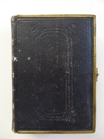 Warrnambool and District Historical Society Inc.
Book, Bible (in Welsh), 1868
... Gaelic Church, Woodford... district and a Gaelic church was operating in Woodford and services ...This Welsh Bible belonged to Ellen Hughes who was Welsh-speaking and the daughter of a farmer from Caernarfonshire, Wales. In 1874 she married William Jones of Warrnambool and became a stepmother to Robert Jones who was to become the owner of the property The Union, near Woolsthorpe. Robert’s daughters, Gwen and Edna Jones, gave this Bible to the Warrnambool and District Historical Society. They were both members of the Society. This book is of great importance as a beautiful memento of the 19th century when the Welsh Calvinistic tradition was strong in the Warrnambool district and a Gaelic church was operating in Woodford and services in Gaelic services were held regularly in Warrnambool. This is a hard cover book with a brown leather cover with gold metal edging and a gold clasp. The cover has embossed patterns on the front back and spine. The pages have gilt edges. The text is in the Welsh language and is presented in two columns per page. There is one blue stamp of the Warrnambool and District Historical Society on the first page. The inscription is handwritten in black ink. ‘Presented to Miss Ellen Hughes by her wellwishers Hugh and Kate Pritchard, Llanfairfechan, July 14th 1871’ ellen hughes, gaelic church, woodford, history of warrnambool, the union -
 Whittlesea Historical Society Inc.
Newspaper - Newspaper Clipping, Copy, Whittlesea Leader, Saved inn nick of time, 10 Aug 2004
... gaelic church service... Church bluestone building cr. walter thomas gaelic church service ...Dr. Richard Ely gives a brief history of the Thomas family history in Mernda and of the bluestone house, "The Poplars", he and his wife Jean purchased in the 1980's.Historical building in the City of WhittleseaNewsprint with 2 black and white photographs.mernda, richard ely, jean ely, the poplars mernda, moses thomas, walter thomas, britannia inn mernda, mayfield presbyterian church, bluestone building, cr. walter thomas, gaelic church service -
 Uniting Church Archives - Synod of Victoria
Photograph, c.1893
Sepia toned photograph, mounted on buff card, of a gaelic service being held outdoors at Cnoc A' Chaisteil, Alness, Ross-shire. "With compliments & every good wish Mrs G.G. Mackenzie Xmas 93"