-
 Lakes Entrance Regional Historical Society (operating as Lakes Entrance History Centre & Museum)
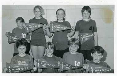
Photograph, 1992
Black and white photograph of eight named children from Johnsonville Primary School Basketball team Runners-Up Tambo Rural Schools competition each child holding a pennant flag. Lakes Entrance Victoriaschools, sports -
 Churchill Island Heritage Farm
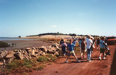
Photograph - Photograph of people walking on dirt road
Churchill Island Heritage Farm has a large photograph collection dating from the nineteenth century.Colour photograph of large dispersed group of people walking along a red dirt road beside the Churchill Island shoreline, with a boy in blue posing for the cameracatalogue number on reverse in pencilchurchill island, photograph -
 Stawell Historical Society Inc
Archive, Woollen Mills Transfer of Share Certificates
North Western Woollen Millsstawell -
 University of Melbourne, Burnley Campus Archives
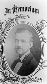
Photograph - Black and white print, J.P. McLennan, Principal, 1917-1977
Donated by Miss Isobel McLennan, McLennan's daughter, in 1977.Black and white photograph. J.P. McLennan, Principal. 2 copies. Copy of a portrait photograph.j.p. mclennan, principal, isobel mclennan -
 Stawell Historical Society Inc
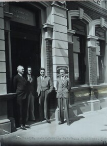
Photograph, State Savings Bank Stawell Branch with four men in suites standing in doorway 1936
Two storey State Savings Bank Stawell Branch with four men in suites standing in doorway. Street Lamp in foreground. 1936L to R: ?? Elliott, W.K.C. Jenkin, A.E. Vagg, D Melrosestawell -
 Stawell Historical Society Inc
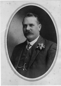
Photograph, Mr Richard H Hart c1884 -- Studio Portrait & his Grave Photograph
Portrait - Richard H. Hart c1884 and photograph of Grave.stawell -
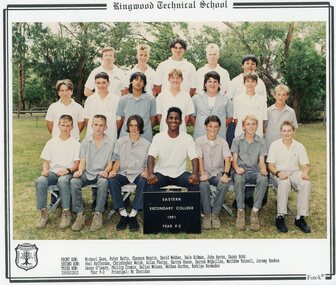 Ringwood and District Historical Society
Photograph - Group, Eastern Secondary College 1991 Year 9.2, c 1991
Colour Photographrts, ringwood tech, esc -
 Stawell Historical Society Inc
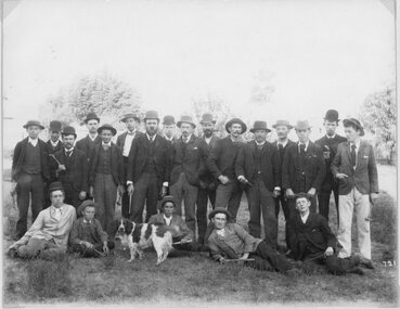
Photograph, School of Mines Stawell - Student Group on an excursion
School of Mines Stawell - Student Group. Note Geology picks probably on excursion.stawell education -
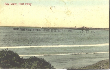 Port Fairy Historical Society Museum and Archives
Photograph - Postcard, Bay view
Hand coloured Photograph/postcard of East beach showing ruins of the pier and in the background the lighthouse keeper's residenceBay Viewbeach, sea, seascape, postcard, east beach, light house keepers house, pier -
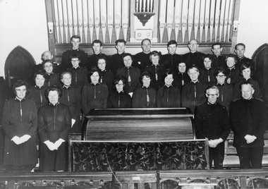 Stawell Historical Society Inc
Photograph, Salvation Army songsters in St. Matthews Church
Group of Salvation Army personnel standing in front of pipe organ in St. Matthew's Church in 1968. Captain & Mrs. Noel Clegg Back Don Reeve, Dennis Tyler,2 Guests, Alf Perry,2 Guests, John White In front of backrow Amy Collins, Cynthia Perry, Eileen Esky, Phyllis Folkes, ?, ?, V White, Gwen Reeve In front of them, guest, Margory Brown, Eileen Clarke, Jenny Biggs, Una Watson, Anita Brown, guest, ?, Janet Tyler Front Ruby SymesMr Capt Noel Clegg, S/Lindsay BrownBlack & white photo of a group of male & female singers in front of a pipe organ. Songsters in St. Matthew's Stawell, pre-Petersham trip 1968.stawell religion -
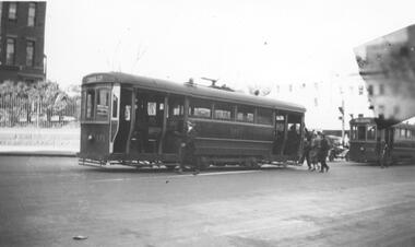 Melbourne Tram Museum
Photograph - Black & White Photograph/s, c1925
Black and white photograph of 2 trams in Swanston St c1925. Building in background may be the Queen Victoria hospital which places the trams just north of Lonsdale St. Photo has imperfection in top left corner of the image. First tram 171 is an S1 class single-truck California combination tram built by MMTB at Coburg Depot. It entered service in June 1922 and was withdrawn from service and sold in 1953. The tram's destination is shown as "Coburg Cemetery". Several passengers are seen boarding the tram. See page 64 of Destination City 5th Edition for another photo of this tram at South Melbourne Depot. The second tram, 178, is a T class single-truck combination tram with a long saloon, built by Duncan & Fraser, Adelaide for the MBCTT. It entered service in June 1917 as tram number 14C before transfer to the MMTB as T class tram. It was withdrawn from service and sold in 1961. This tram was one of only 6 Melbourne trams fitted with long wheelbase Radiax trucks. See page 65 of Destination City 5th Edition for another photo of this tram at Point Ormond terminus.trams, tramways, s class, t class, swanston st, mbctt, tram 171, tram 178, mmtb -
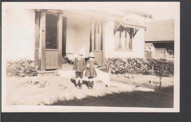 Bendigo Historical Society Inc.
Photograph - PHOTO: TWO CHILDREN
Light Sepia? Photo of two children (boy and a girl) standing in the garden outside a house. The boy is wearing a hat, blazer, shorts, socks and shoes and the girl is wearing a hat dress, socks and shoes. There is a low hedge behind them. The house has a window shade. 460 written on the back in pencil. Baker & Woods Print stamped on the back.photograph, person, male / female, photograph - two children -
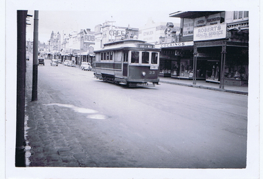 Ballarat Tramway Museum
Photograph - Digital image, Wal Jack, 30/10/1949 12:00:00 AM
Yields information about the appearance of Bridge St and No. 33 in 1949.Digital image from the Wal Jack Ballarat Album of a photograph of No. 33 westbound in Bridge St, with destination of Sturt St West and hand make Auxiliary board "S'pats" Wal's album notes the tram was travelling to St. Patrick College Sports. Photo Wal Jack 30-10-49. In the background are Ezywalkin shoes, Cocking Men's and Boys Wear, Roberts Health Service, advertisement for Robur tea and a cafe. A number of motor vehicles behind the tram. See image i2 for rear of photograph. See image i3 for hi res scan of print. See image i4 for hi res scan of negativeOn rear of photograph in ink "SEC, Ballarat No.33 in Bridge St to St Pats sports Sunday 30-10-49" and in top right hand corner, Wal Jack stamp with "T115" written in.trams, tramways, bridge st, st patricks, tram 33 -
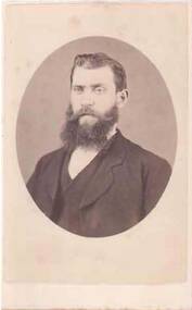 Bendigo Historical Society Inc.
Photograph - PORTRAIT OF A MAN
Small, almost round head and shoulder portrait of a man. He is wearing a jacket, waistcoat and shirt. He has a bushy beard.photograph, portrait, male, portrait of a man -
![View of the River Murray, near Echuca, showing the Railway Wharf with steamers unloading / [by] Nicholas Caire, circa 1876](/media/collectors/550653872162f11fb04854aa/items/57774776d0cdd10a5c111b2d/item-media/57774888d0cdd10a5c11c099/item-fit-380x285.jpg) Kew Historical Society Inc
Kew Historical Society IncPhotograph, Anglo-Australasian Photographic Company, View of the River Murray, near Echuca, showing the Railway Wharf with steamers unloading, c. 1876
Nicholas Caire was born on Guernsey in the Channel Islands in 1837. He arrived in Adelaide with his parents in about 1860. In 1867, following photographic journeys in Gippsland, he opened a studio in Adelaide. From 1870 to 1876 he lived and worked in Talbot in Central Victoria. In 1876 he purchased T. F. Chuck's studios in the Royal Arcade Melbourne. In 1885, following the introduction of dry plate photography, he began a series of landscape series, which were commercially successful. As a photographer, he travelled extensively through Victoria, photographing places few of his contemporaries had previously seen. He died in 1918. Reference: Jack Cato, 'Caire, Nicholas John (1837–1918)', Australian Dictionary of Biography.An original, rare photograph from the series 'Views of Victoria: General Series' by the photographer, Nicholas Caire (1837-1918). The series of 60 photographs that comprise the series was issued c. 1876 and reinforced a neo-Romantic view of the Australian landscape to which a growing nationalist movement would respond. Nicholas Caire was active as a photographer in Australia from 1858 until his death in 1918. His vision of the Australian bush and pioneer life had a counterpart in the works of Henry Lawson and other nationalist poets, authors and painters.albumen silver photograph on boardprinted in ink on support l.c.: VIEW ON THE RIVER MURRAY, NEAR ECHUCA, SHOWING THE RAILWAY WHARF WITH STEAMERS UNLOADING. / COPYRIGHT REGISTERED. printed in ink on support reverse c.: VIEWS OF VICTORIA. / (GENERAL SERIES.) / No. 7. / VIEW ON THE RIVER MURRAY, NEAR ECHUCA, SHOWING THE RAILWAY WHARF WITH STEAMERS UNLOADING. / The rapidly increasing traffic on the River Murray, with wool, timber, and other colonial produce, has called / into requisition no less than 400 steamers and over 1000 barges. To meet this growing emergency the Victorian / Government has expended several thousand pounds in the erection of a Railway Wharf which during the wool- / season presents a very busy scene, the crowded steamers laden with precious clip taxing to the utmost the / powers of the Railway Department in the process of unloading. The River here is about a quarter of a mile wide, / and is from 60 to 70 feet deep. printed in ink on support reverse l.c.l.: J.W. FORBES, Agent, printed in ink on support reverse l.c.: ANGLO-AUSTRALASIAN PHOTOGRAPHIC COMPANY, MELBOURNE. printed in ink on support reverse l.c.r.: 10 Temple Court, Collins Street West.nicholas caire (1837-1918), landscape photography, river murray, echuca -
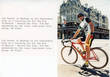 Bendigo Historical Society Inc.
Photograph - BENDIGO ADVERTISER COLLECTION: BIKES, 1990s
Photograph: Man on racing bike in front of Shamrock Hotel Bendigo and attached notes: 'Tim decker of Bendigo on his Cannondale bike on a trainig run for the big VicHealth - Herald Sun Tour. Tim was sponsored by the local road plant hire group, AH Plant.'recreations, sports, cycling, bendigo advertiser -
 Eltham District Historical Society Inc
Photograph - Aerial Photograph, Landata, Eltham; Crown Allotment 15, Section 5, Parish of Nillumbik (Stokes Orchard Estate), Feb. 1979
Centred on present day Diosma Rd, Stokes Pl, Nyora Rd and Eucalyptus Rd Historic Aerial Imagery Source: Landata.vic.gov.au Aerial Photo Details: Project No :1716 Project : WESTERN PORT FORESHORES Run : 15 Frame : 91 Date : 02/1979 Film Type : B/W Camera : RC8 Flying Height : 5500 Scale : 10000 Film Number : 3286 GDA2020 : 37°42'47"S, 145°09'57"E MGA2020 : 338339, 5824447 (55) Melways : 22 C4 (ed. 42) A History of the Development of Crown Allotment 15, Section 5, Parish of Nillumbik – Stokes Orchard Crown Allotment 15, Section 5, Parish of Nillumbik (CA15) is a square allotment of 158 acres or approximately a quarter of a square mile. It lies just beyond the eastern end of Pitt Street, south of Nyora Road to the northern end of Eucalyptus Road and extends east from Eucalyptus Road to Reynolds Road. The topography of CA15 is generally steep, sloping up to a hill near the centre of the land, the ridgeline passing through the properties along the southern side of Diosma Road. Eucalyptus Road is a straight north-south road with its northern end at the north west corner of CA15. Until the end of the 1970s this road was an un-named Government Road and was largely not open to traffic. With residential development in the 1970s the road was constructed, and the council allocated the name obviously in recognition of the predominant species of the local bushland. CA15 was purchased from the Crown by George D’Arley Boursiquot, a prominent Melbourne printer, on 28th October 1852. On November 23, 1922, former Member for Gippsland and Melbourne Real Estate Agent, Hubert Patrick Keogh purchased the allotment then sold it March 13, 1925, to local farmer, Robert David Taylor, a former Shire of Eltham Councillor (1911-1920) and Shire President (1919). Taylor had extensive land holdings stretching west towards Bible Street and Main Road. The Taylor home was situated at the top of the hill in Bible Street at present day 82 Bible Street. At the time of Taylor’s purchase in 1925, CA15 was subdivided into 48 lots that could be described as small rural properties or large residential lots. A typical lot size was one hectare or 2.5 acres. The subdivision created two roads, Nyora Road, and Diosma Road, each following an irregular alignment between Eucalyptus and Reynolds Roads. However, the lots were not sold off separately nor were the roads constructed. The land effectively remained as one parcel for many further years. Robert David Taylor died November 30, 1934, and probate was granted to his son of the same name, Robert David Taylor of Bible Street, Salesman and William McLelland Vance Taylor of 73 Emmeline Street, Northcote, Clerk, with the transfer of the land into their names on July 8, 1935. Frank Stokes worked as a qualified accountant at Kennons leather factory in Burnley, while living at 1 Thomas Street, Mitcham. He suffered from migraines and wanted to return to working the land (he had previously worked on farms and orchards since coming to Australia from England in 1926, both in WA and Vic.). He first travelled to the district by train in July 1942 to find land with the intention to establish an orchard. By chance he met Arthur Bird of Bird Orchard (bounded by Pitt Street, Eucalyptus Road, and Wattle Grove) and they got talking over their common interest. Arthur put Frank up for the night and pointed out the land, 158 acres- part of the Taylor Estate- £900, Crown Allotment 15, Section 5, Parish of Nillumbik (CA15) somewhat diagonally opposite Bird Orchard. Stokes applied through the Riverina Agency to purchase the land who in turn applied for permission from Canberra to sell as there was a new government regulation introduced during the Second World War banning land sales except for immediate production. Stokes obtained a loan on his Mitcham house of £600 @ 5% and paid £450 deposit with quarterly payments of £15 spread over 5 years. Stokes was assisted and advised by Arthur Bird who farmed the neighbouring orchard. In early 1943 Stokes took possession and would catch the train out to Eltham on Fridays after work and began building a hut on the corner of Nyora Road and the Government Road (Eucalyptus Road) for shelter and to lock up tools. He established an orchard on the central western part of the land through the centre of which ran a natural waterway (part of the present-day linear park) and was able to pay a neighbour (Hawkins) to help with clearing and fencing 25 acres, and with a horse and single furrowed plough, planted approximately 2,500 fruit trees - cherries, peaches, plums, almonds, pears, apricots and lemons as well as a few apples and oranges; a massive task. Aerial photographs from the 1940s through to the 1990s clearly show the orchard with most of the larger CA15 site remaining as natural bushland. A huge problem was hares and rabbits eating all the new buds off the tiny trees. As well as laying poison he painted the trees with a mixture of cow manure and lime, often working by moonlight. Procurement of wire and wire netting was difficult because of the war but after much effort he obtained a permit from the Agricultural Department for supplies in March 1944. In February 1945 Stokes applied for a permit to build a “packing shed” as no house building was allowed. It was to be 33 feet x 21 feet and cost £312. It was constructed mostly from second-hand materials, which were hard to obtain, especially iron for roofing. Stokes finished work at Kennons on October 31, 1945, and in March 1946 he sold the family home at Mitcham for £1,230 plus £170 for furniture. On May 15, 1946, title to the CA15 property was issued to Frank Howard Alfred Stokes, Orchardist and Gladys Ethel Stokes, Married Woman, both of Pitt Street, Eltham. The family of five then moved into the very unfinished “packing shed” at Eltham, which was a struggle to weatherproof. Eventually rooms were divided off and lined with hessian bags and whitewashed. Their income was firewood (cut and sold), selling rockery stones and cut Sweet Bursaria. (It was discovered during the 1940s that Sweet Bursaria contained the sunscreen compound Aesculin. The RAAF utilised this compound from Sweet Bursaria during WW2 for pilots and gunners.) The orchard’s first fruit sale was a half-case of Le Vanq peaches in December 1947 for the price of 8 shillings. In 1956 plans for house were drawn and Glen Iris bricks purchased (1956 Olympic Rings variant). The building of the house commenced in 1957 - 12 feet of original packing shed was removed – and was completed in 1959. Water was connected from newly built pressure storage on the property at the end of 1959 and the electricity connection for the first time at 3pm on April 29, 1960. The house remains to present day (somewhat modified) at 1 Nyora Road, home to Nyora Studio Gallery. On occasions, spare remnants of the 1956 bricks have been known to be unearthed in gardens on the estate as they were utilised by Frank Stokes to fill in rabbit holes. On May 26, 1950, a parcel of land was compulsorily acquired by the Melbourne and Metropolitan Board of Works on the hilltop to establish an easement for a high-level service reservoir to augment Eltham’s water supply. The project also included pipe tracks for the necessary water mains. The reservoir has now been superseded by higher level water tanks east of Reynolds Road and its former site is now a public reserve. On November 27, 1964, the State Electricity Commission served notice to compulsorily acquire a further parcel through the eastern part of the land for a major electricity transmission line that augmented supply from the La Trobe Valley to Melbourne. The easement was registered February 11, 1966. The easement was widened July 18, 1969 for a second transmission line to be constructed. In 1971 Melbourne Metropolitan Planning Scheme amendments adopted Nyora Road as the boundary between a residential zone to the north and a rural zone to the south. This determined the future development of the land. In the mid-1970s the Shire of Eltham divided the orchard into numerous rate-able parcel lots, the 48 lots having been established in 1925 and the subsequent rates assessment proved unsustainable for Stokes. He commenced selling lots outside the boundary of the orchard, north of Diosma and South of Nyora. However shortly later the land between Nyora and Diosma Roads and west of the electricity easement was sold and subdivided into residential lots, a housing development by Macquarie Builders and marketed as the Stokes Orchard Estate. New streets were created, and most were named after trees, although one, Stokes Place, commemorates the former owners. The development was undertaken in two stages; Stage 1 (1975) encompassing Scarlet Ash Court, Ironbark Close and Peppermint Grove bounded by Nyora and Eucalyptus roads and Stage 2 (1978) encompassing Stokes Place, Orchard Way, The Crest and The Lookout bound by Nyora and Diosma roads. The developer, Macquarie Builders went bankrupt shortly after the release of Stage 2 leaving many purchasers to fend for themselves and arrange for their own independent builders. There were also difficulties with sewerage for the land immediately south of Diosma Road and so the conventional residential lots were abandoned in favour of larger lots. The development of Orchard Way, The Crest and The Lookout did not proceed as planned and the proposed lots were incorporated into five-acre parcels instead. These included a low-density group housing development by the Graves family and the award winning Choong House (1983) with Gordon Ford developed garden immediately next door situated on the ridge of the hill nestled amongst the original bush, Eucalypt trees and Sweet Bursaria. In 1994, Nillumbik Shire Council applied Significant Environment and Significant Landscape overlays upon the properties on the south side of Diosma Road to ensure protection of this natural bush garden environment. With the arrival of the sewer along Diosma Road in the 1990s, most of these five-acre parcels have since been subdivided multiple times. The Choong house presently sits on a 2.7-acre property, which in 2022 Nillumbik Council nominated for Cultural Significance Heritage protection and is considered potentially significant at State level. The Stokes family were also associated with the Eltham Christian Church. In the 1970s this church had met in temporary premises in Eltham. Lots of the original 1925 subdivision remained south of Nyora Road and a number of these lots were utilized for the Eltham Christian School, which was established by the Eltham Christian Church in 1981. The school operated on this site until 2000. The premises are now used by The Vine Baptist Church. By the mid-1980s the whole of CA15 had been developed for residential and school purposes, except for the sections north of Diosma Road and between the transmission lines and Reynolds Road. Sewerage issues had been resolved for the section north of Diosma Road and in 1987 it was in the process of being subdivided into residential lots. The development coincided with the discovery of colonies of the rare and endangered Eltham Copper Butterfly on the site. This resulted in a community and political campaign to save the butterfly habitat. With the co-operation of the land developer the subdivision was altered to create two bushland reserves in the critical butterfly habitat areas. In the late 1980s the State Government was investigating options for establishing a metropolitan ring road link between Diamond Creek and Ringwood. The chosen route was adjacent to Reynolds Road and so this created a freeze on development of CA15 between Reynolds Road and the electricity easement. The ring road proposal was eventually abandoned, and this part of the land was subdivided into low density residential lots. Diosma Road has been discontinued at the electricity easement and the eastern part incorporated into View Mount Court with access from Reynolds Road. The whole of CA15 has now been developed for residential or associated purposes, ranging from conventional density to quite low density south of Nyora Road. Some remnants of the orchard remain, a few cherry trees on the Graves property and a lone apple tree in Stokes Place. The butterfly reserves comprise significant areas of remnant bushland. Linear reserves through the estate link with central Eltham via the Woodridge linear reserve and with Research along the electricity easement. CA15 as it exists today has a complicated history of rural use, Government acquisition, urban development, and community action. References: • “Stokes Orchard, an incomplete history”; Russell Yeoman with Doug Orford • Correspondence, Beryl Bradbury (nee Stokes) • Aerial Photographs, 1931-1991, Landata (landata.vic.gov.au) • Certificate of Title, Vol. 4930 Fol. 985900 • Plan Number LP 10859 aerial photo, diosma road, eltham copper butterfly, eucalyptus road, ironbark close, nyora road, peppermint grove, peter & elizabeth pidgeon collection, power transmission lines, reynolds road, scarlet ash court, stokes orchard estate, stokes place, woodridge estate, frank stokes -
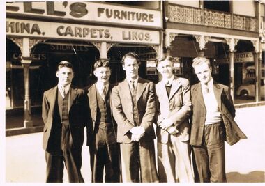 Bendigo Historical Society Inc.
Photograph - JORDAN COLLECTION: PHOTO OF 5 MALES IN FRONT OF STILLWELL'S FURNITURE STORE
Black and white photo of 5 males standing in front of Stillwell's furniture store, located at 293 Hargreaves Street Bendigo (circa) 1930. Stillwell's also had a shop at 281 Hargreaves street selling iron mongery. This information was listed in Bendigo directory dated 1930.bendigo, streetscape, stillwell's furniture store -
 Melbourne Tram Museum
Photograph - Digital Image, Kevin O'Reilly, Royal Park looking east over the Royal Park Hospital, mid 1920's
Image from CD (Compact Diskette for use in computers) - see Reg Item 135. Image titled "Royal Park 2" on CD, of looking east over the Royal Park Hospital in the north west corner of the Royal Park itself. Has the West Coburg tram line in the photograph in the top quarter. The Royal Park railway station and cutting can be seen in the top right hand corner of the photograph. Possibly late 1920's given the construction of the Royal Park tram line was completed through the park in 1925.trams, tramways, royal park, west coburg -
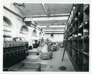 National Wool Museum
Photograph
Depicts the yarn store from one of the Godfrey Hirst mills in 1966. In 1966 McKendrick Consolidated Industries Ltd purchased Godfrey Hirst Ltd to operate a carpet manufacturing concern and this photo was taken at the time of the takeover.Proof IAN HAWTHORNE / PHOTOGRAPHER / Commercial, Portrait, Wedding, Colour Processor / Upstairs, 140 Moorabool St., Geelong Ph. 98096godfrey hirst and co. pty ltd -
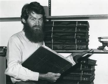 Federation University Historical Collection
Photograph
A msn stand olooking through a large volume. gippsland campus collection, opening of the gippsland campus, churchill, gipplsand institute of advanced education -
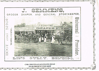 Bendigo Historical Society Inc.
Photograph - LONG GULLY HISTORY GROUP COLLECTION: J SEMMENS GENERAL STORE
Photocopy of a photo of J Semmens General Store, Long Gully, Bendigo. Under the photo is printed on white paper Cnr Creeth & Eaglehawk Road near present Fish Shop. The photo shows the store with the name J Semmens Draper, Grocer, Imperial Cash Store, Hay & Corn Store, Lead & Oils, Boot & Shoe Warehouse. In front of the store is a cart with the name on it with an employee standing at the horse's shoulder, three other employees in front of the store and a horse and buggy with someone sitting in the buggy. Various items are hanging from the edge of the veranda. There is a printed border around three sides of the page.bendigo, history, long gully history group, the long gully history group - j semmens general store -
 Heidelberg Golf Club
Administrative record - Reports, Heidelberg Golf Club, Directors' Reports (Board Papers): Book 33: April 2000, 2000
Typed reports to Directors of Heidelberg Golf Club from the various sub committees: April 2000. Internal title now "Board Papers"Volume 33 of a set of reports to Directors. Black ring binder, multiple pages, unnumbered. committee reports, directors' reports, board papers -
Creswick Campus Historical Collection - University of Melbourne
Photograph - First group of Forestry School Students on the steps of Tremearne House, 1910, 1st Students of School of Forestry
PhotographL to R./ W.Horn. R.Lindsay. H.Felstead. "Forest Assistant" N.Boston. J.Sampson. A.Ken. A.Warren -
Bendigo Historical Society Inc.
Photograph - VICTORIA HILL - VICTORIA HILL FROM RAE'S OPEN CUT
Photocopied photo of Victoria Hill from Rae's Open Cut. In the background are the Poppet legs of the Central Nell Gwynne Mine. On the left background is the Victoria Quartz Mullock. In the foreground are rocks and trees. Photo courtesy of Robert Wallace Studios, 6 Ruth St, Golden Square.photo, victoria hill, victoria hill from rae's open cut, central nell gwynne, victoria quartz, robert wallace studios -
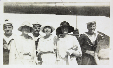 Mission to Seafarers Victoria
Photograph - Photograph, Black and white, 1923
In January 1923, 5 years after the end of WWI, the two French cruisers Jules Michelet and Victor Hugo went on a tour in South East Asia, Australia and New Zealand consolidating the friendship between the countries. The cruisers arrived in January 1923 and Melbournians were invited to visit the ships. Amongst them the ladies from the Guild and especially Dora Walker. In the "Jottings from Our Log"number 69 dated from January 1923 we can read: Our French Visitors The French cruisers, “Jules Michelet” and “Victor Hugo”, each with a complement of 26 officers and 747 men, paid a visit to this port towards the end of the year. Many of the sailors made good use of our institute, and were supplied with French magazines and papers, and were delighted to find that quite a number of ladies could speak French fluently. Over one hundred men were present at the Institute on one of our special nights during Christmas week, when each French visitor was supplied with refreshments and a cigar. Through the great kindness of some of our ladies, each man aboard the two cruisers was supplied with a packet of cigarettes. These were greatly appreciated by the men, and a warm letter of thanks was received from each of the captains."Reflects the close links and mutual friendships developed between French and Australian community developed between LHLG members from 1906 onward especially during WW1 and support of the French Red Cross.Black and white photograph jules michelet, victor hugo, french cruiser, ww1, france, dora walker, french sailors, dora simpson, lhlg, navy -
Lakes Entrance Regional Historical Society (operating as Lakes Entrance History Centre & Museum)
Photograph, Lakes Post Newspaper, 1/02/1995 12:00:00 AM
Black and white photograph of Jarrod Pye and Nicole Leeder tennis champions of the season Lakes Entrance Victoriasports -
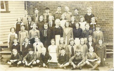 Ringwood and District Historical Society
Photograph, Ringwood State School - Grade 6, 1945
Black and white photographNil -
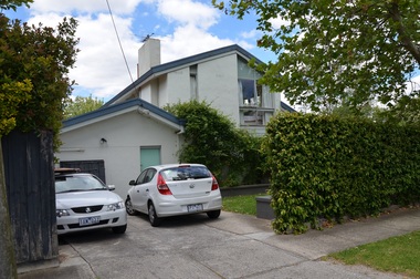 Surrey Hills Historical Society Collection
Photograph - 2 York Street, Mont Albert, On The Street Where You Live Project
Photos documenting this address as part of a photographic series undertaken by volunteer photographers during 2013 and 2014 for The Street Where You Live Project. This was organised through the Surrey Hills Neighbourhood Centre and covered the postcode 3127 in the cities of Boroondara and Whitehorse.These photos provide a snapshot of real estate in the suburbs of Mont Albert and Surrey Hills during a period of rapid change with many properties on large blocks demolished to create higher density residential development or renewal of single dwellings. At particular risk were properties not covered by heritage overlays, especially interwar housing and post 1950's housing. -
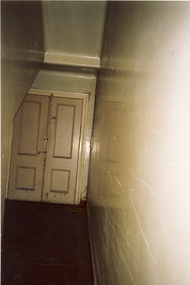 Kew Historical Society Inc
Photograph, Former Willsmere (Kew) Mental Hospital, c.1990
The former Kew Lunatic Asylum, was commenced in 1856 and opened in 1872. At various stages of the institution's history it was named the Kew Lunatic Asylum (1872-1956), Kew Mental Hospital (1956-1960s), Willsmere Mental Hospital (c.1960s-1982), and the Willsmere Unit (1982-1989). Most of the records relating to this former institution are held by the relevant Government Department or by the Public Record Office Victoria. Due to the location of this institution in Kew, the Kew Historical Society also holds an extensive photographic archive as well as significant collections of personal papers collected by staff who worked there.This photograph is one of a series donated to the Society by the photographer, taken following the closure of the Willsmere Unit, and before its redevelopment as a private residential complex. The series is historically significant in that it depicts interior and exterior views of the former institution that were subsequently altered or demolished during redevelopment. A number of the 'views' are socially significant as they allow us to examine the ways in which public institutional architecture in the 19th and 20th centuries responded to the needs of those with perceived mental health issues. Colour snapshot of a part or section of the former Willsmere (Kew) Mental Hospital, taken by Rick Lowell following its decommissioning and before its sale and redevelopment.kew lunatic asylum, kew mental hospital, willsmere mental hospital, willsmere unit, health & human services, mental health, institutional architecture