-
 Creswick Campus Historical Collection - University of Melbourne
Administrative record - Board of Forestry Education - examinations, results and reports, Board of Forestry Education et al
School Change documents including agreement between FCV and Uni Melb. UnsortedDocuments -
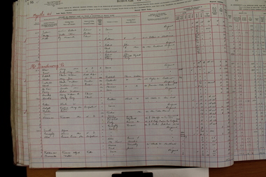 Ringwood and District Historical Society
Administrative record - Rate Books, Borough of Ringwood Valuation & Rate Book for 1926-27 (Assessments 1921-2105), March 2012
Originally stored at Ringwood Council offices, then taken to PROV.Only source of ratepayers in the Borough of RingwoodDigital images -
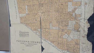 Peterborough History Group
Map - Map of the Parish of Nirranda, Parish of Nirranda
Map of the Parish including roads, names of landowners, location of schools etc in 1939A3 size map of the Parish of Nirranda in 1939nirranda, maps, parish map -
Glenelg Shire Council Cultural Collection
Administrative record - Report - Portland Harbour Trust Commissioners, c. 1971
Two copies of report produced by Portland Harbour Trust Commissioners detailing construction and facilities of the present harbour, 1950 -1971 -
University of Melbourne, Burnley Campus Archives
Plan (Item) - Plans & elevations, [Bookshop] Plans & elevations Burnley Horticultural College
dairy, student bookshop, burnley horticultural college -
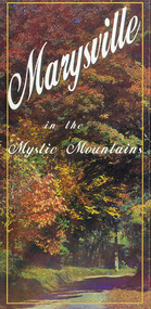 Marysville & District Historical Society
Map (Item) - Information brochure, Project Art & Photo, Marysville in the Mystic Mountains, Unknown
An information brochure on Marysville, the surrounding district and the natural attractions in the region published by Mystic Mountains Tourism.An information brochure on Marysville, the surrounding district and the natural attractions in the region published by Mystic Mountains Tourism.marysville, victoria, australia, information brochure, mystic mountains, mystic mountains tourism, cathedral range, lady talbot drive, cameron cascades, phantom falls, keppel falls, beech forest cascades, the beeches rainforest walk, the big tree, cumberland memorial scenic reserve, cambarville, cumberland falls, cora lynn falls, the big culvert, steavenson falls, lake mountain, marysville visitor information centre -
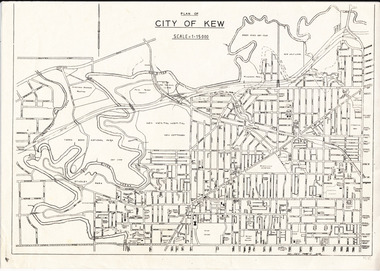 Kew Historical Society Inc
Plan, City of Kew, 1979
Plan of the City of Kew produced for public distributionPlan of City of Kew - Scale 1 : 15000Revised June 1979plans - city of kew (vic.), maps - kew (vic.), local government area - kew - victoria, cartography -
 Bendigo Military Museum
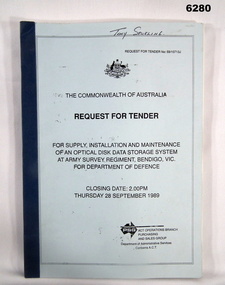
Administrative record - RFT - Supply and Maintenance of an Optical Disk Data and Retrieval Storage System, PSG Operations Branch, Purchasing and Sales Group, Department of Administrative Services, Canberra ACT, September 1989
This Request for Tender (RFT) 59/10713J is for the archival storage of digital mapping data produced by the Automap 1 and Automap2 computerised mapping systems. The RFT Closed on 28 September 1989.A4 Booklet, Light Blue Cover, Dark Blue plastic Bindingroyal australian survey corps, rasvy, fortuna, army survey regiment, army svy regt, asr -
Bendigo Historical Society Inc.
Map - GREAT EXTENDED HUSTLER'S MINE - LONGITUDINAL SECTION OF THE GREAT EXTENDED HUSTLER'S MINE
Longitudinal Section of the Great Extended Hustler's Mine on the Hustler's Line of Reefs. Bulletin No 33, Plate No XIII. Map shows the Hustler's Tribute, 2 Old Shafts, Great Extended Hustler's Shaft, Latham & Watson's Shaft and Ironbark Gully. Datum Line 750 feet above Sea Level. Poppet Legs on the surface and Sill of Shaft 788.99 feet above Sea Level. Levels and their depths are shown and some geographical features. Some amounts of gold mined mentioned. Geological Survey of Victoria emblem and signed by H A Whitelaw, Underground Survey Office Bendigo, September 1913. Note - Plates 4, 8, 13,20, 26 & 31 form a Longitudinal Section from Fortuna Hustlers to Hustler's Consols Mine. This item has not been scanned or photographed.mining, parish map, great extended hustler's mine, longitudinal section of the great extended hustler's mine, geological survey of victoria, underground survey office bendigo, h a whitelaw, hustler's tribute, old shaft, great extended hustler's shaft, latham & watson's shaft, ironbark gully -
Glenelg Shire Council Cultural Collection
Administrative record - Ledger - Prescription Book, October 1952 - August 1954, 1952-1954
Local ChemistFront: n/a -
Glenelg Shire Council Cultural Collection
Plan - Ship Plan / Mould, n.d
Wooden pattern for mould for boat fitting. Solid cylinder, with smaller diameter cylinder attached to one end. Painted yellow/orange. -
Moorabbin Air Museum
Administrative record (item) - Maintenance Form Canberra A84-222
-
Glenelg Shire Council Cultural Collection
Plan - Plan - S.S Admella Model Plans, SS 'Admella', n.d
Photocopy of model plan for lines and general arrangement of SS 'Admella'. scale 1:48. Photocopy paper is parchment style. Plan used by 'Float-a-boat' model makers for the construction of the Admella model acquired by Grant District council. -
Glenelg Shire Council Cultural Collection
Administrative record - Police Report - theft of hurricane lamp, 1914, 03/10/1914
Barry was a police officer stationed at Portland 1969 - 71. Stables were to be demolished. he was instructed to clean them out, and take the contents to the tip. He retained these documents and donated them to the Cultural Collection.Hand written supplementary Police Report of Criminal Offence - larceny, one hurricane lamp, Yeitz pattern, glass lined, in good condition, Hamilton police stationBack: 'Warrnambool 6/10/14 RH Portand' hand written , black penpolice report, theft, hamilton police station -
Moorabbin Air Museum
Map (Item) - route map of Australia, ANA australian national airways
-
Glenelg Shire Council Cultural Collection
Administrative record - Notebook - Ancient Order of Foresters, c. 1932
Notebook, green, hard cover, red spine, indented alphabetical sections. Contains hand written lists of members (not Portland but greater district)Front: inside front cover 14/6 top left, pencil white label, black print, maker's detailsancient order of foresters, friendly society, administrative record -
Glenelg Shire Council Cultural Collection
Plan - Ship Plan / Mould, n.d
Wooden pattern for mould for boat fitting. Cylinder with two short wooden dowels protruding from top. Cylinder painted pale yellow, dowels unpainted. -
 Ringwood and District Historical Society
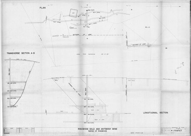
Plan - Department of Mines, Victoria, Ringwood Gold and Antimony Mine - 1921
Technical drawings of Antimony Mine - Plan view, Transverse Section view, and Longitudinal Section view. Includes Main Shaft, No.1 Level 184', No.2 Level 244', No.3 Level 304', No.4 Level 372'. Multiple copies, including copy with overlay of Civic Centre.Scale 40 feet to 1 inch. Surveyed 20-12-21. Traced 1-7-66. W-2568/B/1. -
 University of Melbourne, Burnley Campus Archives
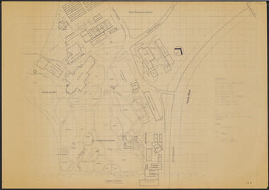
Plan, Victorian College of Agriculture and Horticulture - Burnley Site Plan, 1986
Given to Archives by Jim Galea (Staff 1985-87).Prints and paper copies of plan of Burnley Campus by Fresco Color Group No 60 337-A dated February 1986. Scale 1:500. (1) 3 prints of the plan, 1 small, 2 larger (1 with legend and grid). (2) Tracing paper copy, no legend, no grid. (3) Paper copy, legend and grid, of Ornamental Garden Area. (4) "Drawing Orchard Site Plan," grid and legend printed, the rest hand drawn. (5) Film and paper copies without grid and legend. N.B. 11.0716, Further development of Plan. vcah, burnley -
 Bendigo Military Museum
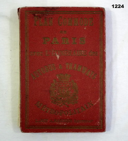
Plan - MAP, TOURIST, L Joly, A Maunier, WWI
The map belonged to Jack Grinton No 1043 38th Batt AIF. At Wars end extensive leave was granted, Jack journeyed to Paris, Nice, Monte Carlo taking many photos. Part of the Grinton collection which included hundreds of negatives and developed photos that he took during the War. Refer Cat No 1280 for service details. Refer 1317P, 1320P.Map of Paris. Red cardboard or paper hardcover, new edition guide of metropolitan Paris (ministries, tramways, monuments), Index in front, folded paper map attached to back cover. "Plan commode de Paris avec l'itineraire des autobus & tramways metropolitan"documents-maps, french -
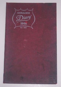 Ballarat Tramway Museum
Administrative record - Log book, Diary, Collins Bros, 1967
Yields information about the tramcar maintenance activities of the SEC at the depot in frequency of changing brake blocks, light bulbs, trolley rope and wheels for each tramcar.Collins Diary No. 324, 1968, red Rexene covers, sewn sections with ruled sheets providing a diary for 1968, 7 days and notes for each double page. Has "useful information" sheets at from the diary. Used by the SEC Ballarat depot to record brake block changes and light globe replacements on each tramcar. Also gives details on trolley rope and trolley wheel replacements.tram, trams, sec, ballarat, depot, brake blocks, trolley wheels -
Bendigo Historical Society Inc.
Map - REDESDALE : COUNTY OF BENDIGO, 24-12-24
Map. Redesdale, County of Bendigo, County of Dalhousie, Kimbolton, Langwornor, Spring Plains, Glenhope, Emberton, Metcalfe, Hawkestone, County of Talbot, Campaspe River, Back Creek, River Coliban, Lyell. By authority H.J. Green, Government Printer, Melbourne. Photo-Lithographed at the Department of Lands and Survey, Melbourne by W.J. Butson, 24-12-24, Price 1/-. (number 120 in map cupboard 1)H.J. Green, Government Printer, Melbourne.map, bendigo, redesdale -
 Kew Historical Society Inc
Plan, Survey Plan, Park Hill Road, Kew, 1880-1890
The streets identified on the survey plan - Cotham Road, Park Hill Road East, Park Hill Road West in Kew were each gazetted by the Victorian Government in 1865. The hand-coloured survey plan was completed by Holland Loxton, Town Clerk and Surveyor of the Borough of Kew from 1866. The unnamed survey plan includes names of land owners in addition to measurements (2 chains to 1 inch) and streets. Named owners include Webster, Payne and Francom which will enable us to narrow down the creation date of the survey.Handdrawn survey plan by a former surveyor and town clerk of KewHand drawn and coloured survey plan created by Holland Loxton, Surveyor and Town Clerk of Kew, showing land owned by Payne in Park Hill Road, Kew. The plan includes street names, land measurements and land owners.surveys - kew, maps - kew, holland loxton, park hill road - kew, holland loxton -- surveyor, survey plans -- parkhill road -- kew (vic.) -
 Vision Australia
Administrative record - Text, Royal Victorian Institute for the Blind annual report 1952-1953, 1953
Events that occurred during the year : through the kindness of 3KZ and Institute will participate in the proceeds of the Carols by Candlelight festival and the 3KZ Christmas Day Appeal, 5000 pounds received from the Estate of the late Mrs A.B. Potter, Country Concert Party managed by Alf Broadway and led by Dick Sutcliffe raised over 9000 pounds, Harry E Finlayson has returned has Headmaster, the Girl Guides company and Scout Troop are ably led by Alma Cockerill and John Dammon respectively, and Cubs by Emily Bombardieri, a past student has received his degree and will take up a position as a teacher in a sighted school, complete reconstruction of the pipe organ was achieved (with a brief history of past events), the Board was able to make a contribution to recent Interstate Carnival conducted by the Australian Council of Blind Cricketers, and the relatively new sport of Football, with an visit of the Victorian team to their New South Wales counterparts, Harry Lloyd is conducting carpentry classes, Mr F Nixon continues to operate the Kiosk, new pupils continue to join the piano turning courses run by Harry Andrew, the retirement of S.W. Hedger after 32 years of service and appointment of K.R. Bunn as Chief Executive Officer.1 volume of text and illustrationsannual reports, royal victorian institute for the blind -
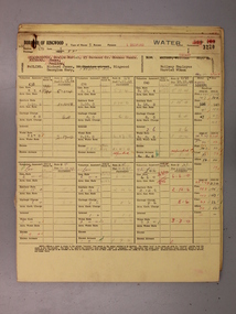 Ringwood and District Historical Society
Administrative record - Rate Books, Borough of Ringwood Valuation & Rate Cards for 1944-49 (Assessments 3220-24), March 2012
Originally stored at Ringwood Council offices, then taken to PROV.Only source of ratepayers in the Borough of RingwoodDigital imagesBedford Road, Ringwood. For Richard & Georgina Pauline, Annie Cubbit, Bruce Gibson and Ringwood Borough Council. -
Bendigo Historical Society Inc.
Map - PASTORAL HOLDINGS, See above
Map: Copy of 'Map showing the Pastoral Holdings of the Port Phillip District 1835-51, Now Victoria'. Comiled by A.S.Kenyon M.I.E. Aus. Historical society of Victoria 1932map, victoria, pastoral holdings, pastoral holdings, port phillip district -
Glenelg Shire Council Cultural Collection
Administrative record - Application Form - Ancient Order of Foresters Initiation as a Mortuary Benefit Member, n.d
The Ancient Order of Foresters, which originated in England in the mid 1700s, established its first branch (Court) in Victoria in 1849. Foresters was set up as a non-profit organisation, the founding principles of the Society being to provide financial and social benefits as well as support to members and their families in times of unemployment, sickness, death, disability and old age. The Society is now known as the Foresters Friendly Society and in July 1999 was incorporated as a public company limited by shares and guarantee.Schedule K, form of application by a candidate for Initiation as a Mortuary Benefit Member. -
Glenelg Shire Council Cultural Collection
Administrative record - Ticket, n.d
Victorian Railways cloakroom ticket, green and buff, heavy card, black print. No. 0135 Terang.victorian railways, ticket, terang -
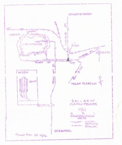 Ballarat Tramway Museum
Map, Ballarat and Bendigo tram systems, 1962 and 1965
Set of two spirit duplicated maps of the Ballarat and Bendigo tram systems, showing the track layout for both cities. .1 - Ballarat - dated 1962, noted as being traced from Electric Traction 12/62. .2 - Bendigo - dated 1965, noted as being tracked from ET 6/65. Most likely used for tour notes or other similar productions.trams, tramways, map, ballarat, bendigo -
Clunes Museum
Map
Map recovered from Estate sale at 31 Service Street, Clunes (former Fraser family residence and originally Shrigley residence)This item was donated by Catherine Jenkins/James Curzon from the Estate sale of Mr. Albert FraserMap of Clunes township printed on buff paperPrinted on front: In black ink, "Shire of Talbot and Clunes, Shire Eng. (name Illegible Boyd?) -/10/74map, clunes township, mr albert fraser, 31 service street