-
 Kew Historical Society Inc
Map, MMBW, MMBW Plan No.67 Kew, 1900-1910
The Melbourne and Metropolitan Board of Works (MMBW) was established by an act of the Victorian Parliament in 1890 to prepare for and to implement a sewerage and water reticulation system across what was then inner Melbourne, its surrounding and middle distance suburbs, including Kew. The MMBW was disbanded in 1991.The map collection of the Kew Historical Society has at its core the historic maps assembled and originally stored in the City Engineer's Department of the City of Kew. These include maps in a number of scales. The vast majority of maps were produced by the MMBW in the first two decades of the twentieth century, and are solid working maps, backed by linen for durability. These maps are historically significant to Kew, the City of Boroondara and to the history of the development of state utilities in Victoria. A number of the Kew maps have additional details added by former municipal officers, including the levels reached by various floods. As these were working documents, information was added to them long after the period of their initial production and distribution.Early map of part of the Borough of Kew, created in the first decade of the twentieth century, at a scale 160 ft to 1 inch. The map covers what was then the north central part of Kew, bordered on its north by the Outer Circle Railway Spruzen and Beresford Avenues, in the west by Princess Street, in the south by High Street, and in the east by (about) Belford Road. The map shows the extent of urban development by that time, prominent institutions and the outlines of built structures in the municipality. Contour lines were added in ink to the map at a later stage.MELBOURNE AND METROPOLITAN BOARD OF WORKS / PLAN NO. 67 / KEW melbourne & metropolitan board of works, mmbw maps, mmbw plans, borough of kew, cartography -
 Port Melbourne Historical & Preservation Society
Map, Port Melbourne Sheet 1, 1962
Framed line drawing map of Port Melbourne (sheet 1) 1962, covering the area from Coode Canal to Plummer St and Todd rd to Boundary Stlocal government - city of port melbourne -
Stawell Historical Society Inc
Map, Shire of Stawell
Shire of Stawellstawell -
Port Melbourne Historical & Preservation Society
Plan - Wharf area behind Berth Numbers 25, 26 & 27 South, Engineering Division, Port of Melbourne Authority, 1970
Plan - General layout of wharf area behind berth No.s 25,26 & 27 South, 1970smelbourne harbor trust - port of melbourne authority -
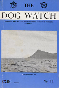 Mission to Seafarers Victoria
Journal (item) - Periodicals-Annual, Shiplovers' Society of Victoria, The Annual Dog Watch
This journal provides the reader with glimpses of the adventures and hardships of a seaman's life. Many of the stories are of sailing ships.Contributes to our knowledge of the importance of shipping and places on record those stories of the sea which would otherwise be lost.Contents Foreword - Captain Sir John P. Williams, C.M.G., O.B.E.- 5 Editorial - C. A. Halls - 8 The Cape Horners - S. A. E. Strom - 13 Cape Horners (Verse) - C. E. Bonwick - 21 "All the World Lovers . . ." - Dr. Stanislaw Bernatt - 24 "Beatrice" Memories - Captain H. P. Nicholson - 25 Maritime Bottle Post - E. Harper - 30 The Saltpetre Cross - Captain Leif Asklund - 32 The "Caledon" - R. N. Thiele - 34 The Last Voyage of the "Olivebank" - Captain Evert Blomqvist - 39 The Figurehead on Macquarie Island - E. A. Mitchener - 44 The Ups and Downs of Dougherty Island - Captain W. B. Eastoe - 51 "Pom" Apprentice - Captain Frank Kirk - 57 A Fortunate Encounter - D. R. Rickard and A. Stallard - 61 Times Remembered; - Captain Bruce Bell - 65 Service in the 10th Cruiser Squadron, 1916 - From the papers of the late Captain W. J. Cowling - 71 Cape Horn - Captain G. Molyneux - 79 Immigrant to the Antipodes - H. Vaughan Evans - 82 The "Lauriston" -- Start of Bad Weather - R. W. Rudd - 85 Songs of the Finnish Sailormen - Captain Eino Koivistoinen - 89 Farewell Windjammer - Chris. A. Smith - 92 The Voyage of the "Storm King" - N. S. Smith - 100 Editors' Comment - - 105 An Australian Shell Back - Captain G. Heyen - 107 First Voyage in the S.S. "Port Campbell" - I. L. Barton - 111 A Few More Ships - - 120 Book Reviews - 121sailing ships, steamships, shipping, seafaring life, shiplovers' society of victoria, dog watch, cape horn -
 Kew Historical Society Inc
Map, Department of Lands & Survey, Map of Melbourne & Suburbs, 1899
The Melbourne & Metropolitan Board of Works was established in 1891 to oversee the introduction of a sewerage and water reticulation system in Melbourne and its suburbs. This complementary map was produced by the Department of Crown Lands & Survey [Victoria] in the same decade showing the distribution of water in Melbourne for use by fire brigades. While by 1910, there were 123,227 connections to Melbourne's water supply system, it is unclear in this 1899 map whether water was supplied to all built structures in the defined areas or only to fire hydrants and stand pipes, as we know that the first connection of a building to the sewerage system in Kew only occurred in 1904.Map accompanying report on fire protection of Melbourne showing those areas supplied with water in colour.water reticulation -- melbourne (vic.), department of lands & survey -- historic maps, fire brigades -- melbourne (vic.), cartography -
Moorabbin Air Museum
Administrative record (item) - Assembly Flame Tubes Nos.1,2,4,5,6,7 & 9 BK 2249/3
-
Charlton RSL Sub Branch
Administrative record - WW1 Discharge papers, WW1 Discharge papers for Leslie Hiram Jones July 30, 1919
Papers for discharge WW1 (laminated)No. 2282. 5th Battalion. 30.7.1919. 1413 days overseas service. Issued Melbourne. -
Stawell Historical Society Inc
Map, Jallukar, County of Borung, 1971
Jallukar, County of Borungstawell -
Mission to Seafarers Victoria
Administrative record - Annual Report, Mission to Seafarers Victoria, Annual Report 2021, 2022
annual report, 2021 -
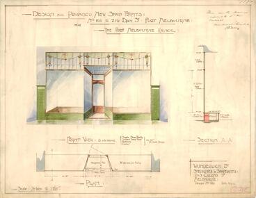 Port Melbourne Historical & Preservation Society
Plan - Proposed renovation to shop fronts, Bay Street, Port Melbourne, Wunderlich Ltd, 14 Feb 1916
Plan of design for proposed renovation of shop fronts for nos. 191-219 Bay Street (market buildings) for Port Melbourne Council. Plus master copy for photocopies.Drawing endorsed by R.N. Solly representative of Wunderlich Ltd in top right hand corner: No. 695 in bottom right hand cornerbuilt environment - commercial, market reserve, wunderlich ltd, bay street -
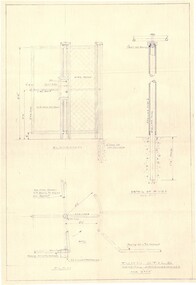 Falls Creek Historical Society
Plan - Diagram of Turnstile for New Chairlift
Bob (Herman) Hymans (a former member of the Royal Netherlands Navy was born in Bloemendaal, Holland on 30th September 1922. During World War II he fought against the Japanese in the Dutch East Indies (now Indonesia) and was imprisoned in Changi and on the Burma Railway. After gaining qualifications as a Ski Instructor, Bob arrived in Falls Creek in May 1950. Working as an Instructor and Supervisor at Bogong Lodge, Bob decided his future was in accommodation. He was successful in negotiating an indenture for land from the State Electricity Commission (SEC). It took Bob two years to build his Grande Coeur Chalet but, tragically, it was burned down in August 1961. Bob also built the first Chairlift in Australia. This was a single chairlift and the structure was built from wooden electricity poles. He was constantly full of new ideas and proposals for the village. Bob Hymans died on 7th May 2007. This Collection of documents and letters tells the story of Bob’s endeavours to develop Falls Creek into the ski village it is today. This map is significant because it documents plans made by Bob Hymans for Falls CreekThis diagram is part of Bob Hymans documents. It is a detailed plan, including elevation, detail of pivot and the general arrangement views of a turnstile. This is part of overall plans for the construction of a new chairlift at Falls Creek. At bottom of diagrams: PLAN TURNSTILE/ GENERAL ARRANGEMENT Scale 1 1/2" = 1'- 0"map of falls creek, falls creek leases, falls creek 1980s -
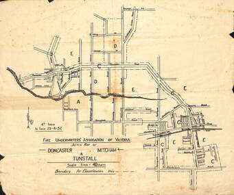 Whitehorse Historical Society Inc.
Map - Fire Underwriter's Association Sketch Map, Fire Underwriter's Association of Victoria, Doncaster, Mitcham and Tunstall, 29/4/1932
Shetch map of Doncaster, Mitcham and Tunstall. Scale 1inch = 40 chainsA sketch map of Doncaster, Mitcham and Tunstall by the Fire Underwriters' Association of Victoria.non-fictionShetch map of Doncaster, Mitcham and Tunstall. Scale 1inch = 40 chainsmap, doncaster, mitcham, tunstall -
Moorabbin Air Museum
Plan (item) - Bristol Aeroplane 170 schematic drawings, Circuit Ident Chart - Basic
Bristol Aeroplane Company Ltd -
Moorabbin Air Museum
Administrative record (item) - RAAF Wirraway Aircraft Servicing And Maintenance Form E/E.77 Travel Copy - A20-702, Royal Australian Air Force, Travel Copy: Aeroplane Maintenance Form E/E. 77, 24/07/56
Contains daily inspection and test flight records. -
 Bendigo Historical Society Inc.
Administrative record - Lands Office Bendigo - Residence area applications
Green and red hardbound book. It contains handwritten details of applications of residence area licenses under part II of the land's act 1869. It covers the period from 02-11-1881 to 25/11/1881.Application Register part 2, land act 1869 on the spine. On the first page in pencil: Soloman Paul, Hill Street Sandhurst.land office, residence area licenses -
 Bendigo Military Museum
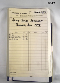
Administrative record - Army Survey Regiment Officers Mess Ball 1995, Army Survey Regiment, Bendigo, 1995
The Army Survey Regiment held Annual Balls at Fortuna Villa. This folder contains the documentation for the Logistics and activities associated with the planning and running of the Officers and Sergeants Mess Ball held in 1995. The folder also contains an after action review of the ball.Cloth bound manila Correspondence Folder containing minutes and correspondence for the Officers and Sergeants Mess Summer Ball of 1995royal australian survey corps, rasvy, fortuna, army survey regiment, army svy regt, asr -
 Melbourne Tram Museum
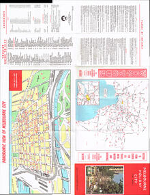
Map, Victour, "Melbourne Holiday City", c1975
Map - 12 fold special size - full colour titled "Melbourne Holiday City", published by Melbourne Tourism, c1975 prior to the construction of East Burwood tram line, providing a list of amusements, tourist locations, places of interest, map provided by Victour, The Victorian Government Tourist Bureau, a panoramic view of Melbourne and a large map of Melbourne and suburbs showing rail, bus and tram lines and key to suburbs. Cover photo with 882 (Route 11, Spencer St) in Collins St looking west with the Westgate bridge in the far background.trams, tramways, map, public transport, city of melbourne, buses, railways, tramways, victour, tram 882 -
 University of Melbourne, Burnley Campus Archives
Plan, Alexander Metherell, Library - Boulevard/Engineering Block, 1983
(1) Site Plan by Alexander Metherell Pty. Ltd. Job No BHC/1 Drawing No SP/3 dated Dec 1983. On reverse, Plan SP/3 Library - Boulevard." (2) 4 tracing paper copies with various annotations. (3) Tracing paper planting plan. (4) Coloured, laminated copy, Proposed Planting: Engineering Block and 2 sketches on tracing paper and paper. Also see B15.0352 for Full Report.alexander metherell, library -
Bendigo Historical Society Inc.
Map - NERRING, 15/06/1937
Map: Parish of Nerring, County of Bendigo. Parish plan Canvas backed ( number 139 in Map Cupboard 1)map, bendigo, rural, nerring, county of bendigo -
 Bendigo Military Museum
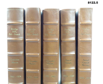
Administrative record - VOLUMES, BDRSL MINUTES
On the spine in gold on all "Bendigo RSL Sub - Branch", on three, "Committee Minutes, on one "Annual reports" and last, "Annual General Minutes". The years to each specific volume. When the History of the Bendigo RSL was being compiled by Murray Poustie the original foolscap documents were put together and then reprinted in these volumes in A4 size. Refer Cat No 8093 re the history Bendigo RSL Sub Branch..1 - .3) Three leather bound volumes with brown spine and corner covers, front and back face green, on the spine is text in gold. These are the minutes of the Bendigo RSL Sub Branch from 1960 - 2000 being 1960 - 74, 1975 - 91 and 1992 - 2000. .4) Same leather volume these being the Annual Reports of the Sub Branch from 1964 - 2000. .5) Same leather volume these being the Annual General meetings from 1949 - 2014. Each has a black book mark ribbon. As well each is slightly different in thickness size.brsl, smirsl, volumes -
 Kew Historical Society Inc
Plan, Melbourne & Metropolitan Board of Works : Borough of Kew : Detail Plan No.1573, 1905
The Melbourne and Metropolitan Board of Works (MMBW) plans were produced from the 1890s to the 1950s. They were crucial to the design and development of Melbourne's sewerage and drainage system. The plans, at a scale of 40 feet to 1 inch (1:480), provide a detailed historical record of Melbourne streetscapes and environmental features. Each plan covers one or two street blocks (roughly six streets), showing details of buildings, including garden layouts and ownership boundaries, and features such as laneways, drains, bridges, parks, municipal boundaries and other prominent landmarks as they existed at the time each plan was produced. (Source: State Library of Victoria)This plan forms part of a large group of MMBW plans and maps that was donated to the Society by the Mr Poulter, City Engineer of the City of Kew in 1989. Within this collection, thirty-five hand-coloured plans, backed with linen, are of statewide significance as they include annotations that provide details of construction materials used in buildings in the first decade of the 20th century as well as additional information about land ownership and usage. The copies in the Public Record Office Victoria and the State Library of Victoria are monochrome versions which do not denote building materials so that the maps in this collection are invaluable and unique tools for researchers and heritage consultants. A number of the plans are not held in the collection of the State Library of Victoria so they have the additional attribute of rarity.Original survey plan, issued by the MMBW to a contractor with responsibility for constructing sewers in the area identified on the plan within the Borough of Kew. The plan was at some stage hand-coloured, possibly by the contractor, but more likely by officers working in the Engineering Department of the Borough and later Town, then City of Kew. The hand-coloured sections of buildings on the plan were used to denote masonry or brick constructions (pink), weatherboard constructions (yellow), and public buildings (grey). This plan has detailed annotations written in red or blue ink, showing prices, which may be the annual valuations of the properties, and some owners’ names, a most unusual feature on contractor's maps. Some areas, such as the buildings of Methodist Ladies’ College (MLC), include the school’s tennis court and swimming pool, but are not coloured to show building materials – did the draftsman just run out of time, or ink, or enthusiasm, before his plan had to be submitted? MLC had been founded in 1882 as a ‘modern school of the first order’ with buildings that formed ‘a collegiate institution for girls unsurpassed in the colonies’. The goal of its founders was to provide a high-class Christian education for girls, comparable with that provided elsewhere for boys. Some shops are shown along Edgevale Road, though they are not designated as commercial premises. Larger houses are depicted, including ‘Fairlawn’ in Barkers Road, and ‘Clevedon’ and ‘Rosehill’ (now demolished) in Fitzwilliam Street.melbourne and metropolitan board of works, detail plans, mmbw 1573, maps - borough of kew, cartography -
Lakes Entrance Regional Historical Society (operating as Lakes Entrance History Centre & Museum)
Administrative Record - Red cross News Letters, Lakes Entrance Red Cross News Letters
purple folder March 1998 - Feb 2004documents, reports -
 Mission to Seafarers Victoria
Administrative record (item) - Minute Book, Norman Bros, 5th Minute Book L.H.L. Guild - April 1940 to 1945, Circa 1940
Documents the minutes from the Ladies Harbour Lights Guild from the 9th of April, 1940 to the 12th of June, 1945. The minutes lists the dates, locations and attendance of all meetings during this time. The book also makes reference to world events, such as WWII - on the 8th of May, 1945, "The Chaplain opened the meeting with prayers & thanksgivings for the cessation of the European war announced in the morning paper".This is a record of all members, meetings and activities undertaken by the Ladies Harbour Lights Guild between 1940 to 1945. As this was during the Second World War, the book is an important documentation of the "home front".Front cover: 5TH MINUTE BOOK / L.H.L. GUILD / APRIL 1940 / TO 1945 handwritten in black ink. THE CLASSIC / SERIES printed in a decorative box. LHLG MINUTES 45 / 4/1940-6/45 handwritten in black ink on a white sticker. NORMAN BROS printed at the bottom of front cover.1940, 1945, minutes, williamstown, wartime, celia-little-hall, lhlg, ww2, ladies harbour lights guild, lhlg minutes -
University of Melbourne, Burnley Campus Archives
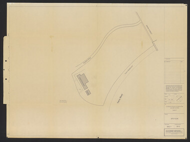
Plan, St James Park Feature Plan, 1983
City of Hawthorn Plan, drawing No P24/19, Sheet 1 of 1. Surveyed by L.B. & H.K. Traced by H.K. Aug 83. Scale 1:500.hawthorn, st james park -
Glenelg Shire Council Cultural Collection
Plan - Ship Plan / Mould, n.d
Wooden pattern for mould for boat fitting. Oval shape, with oval hole in centre, curved edge. Unpainted, except for base, painted white. -
 Kadimah Jewish Cultural Centre and National Library
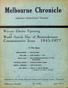
Journal, Kadimah Jewish Cultural Centre and National Library, Melbourner Bleter / Melbourne Chronicle April 1977, ADD DATE
Journal published by the Kadimah Jewish Cultural Centre and National Library, Melbourne. Contains essays, reviews, fiction and poetry in both English and Yiddish.44 pages, A4, Softbound, Paper covers. non-fictionJournal published by the Kadimah Jewish Cultural Centre and National Library, Melbourne. Contains essays, reviews, fiction and poetry in both English and Yiddish.serge i. liberman, irena klepfisz, ron abel, masha leon, gedaliah shaiak, amy stone -
Moorabbin Air Museum
Plan (item) - C.A.C Wirraway Agricultural Conversion XP.77
-
 Bendigo Military Museum
Administrative record - Army Survey Regiment - Report on Automated Data Processing since 1984
A comprehensive summary of Automated Data Processing at the Army Survey Regiment with a description of each. Textronix 4052, PDP 11/70, Quantex Replay Unit, Automap 1, Automap 2, Konsberg GT5000, RTE 6, Autochart, Plot 79, IGDS, Schut Bundle, DTM - Nucleus, DTM - Graphics, ASMAPS, ASTIS, PAT-B, PRE-B5, PAT-M, PRO-MS.Typed Report, 3 x foolscap photocopy pagesroyal australian survey corps, rasvy, fortuna, army survey regiment, army svy regt, asr -
 Bendigo Historical Society Inc.
Administrative record - Provisions Register 1897 - 1908
The Benevolent Asylum was established to provide both indoor and outdoor charitable relief for the destitute and aged. Initially it was in a slab and weatherboard building before getting it's permanent home in 1860. (Now Ann Caudle Centre). From 1868 - 1885 an industrial school for children was included. In 1884 a Lying in Hospital was included and this closed in 1920.Bendigo Benevolent Asylum Provisions Register 1897 - 1905. Green coloured marbled pattern cover with red and white tape on the spine with lined ledger pages. The ledger includes the provisions acquired and dispersed each day. All entries handwritten in ink. Standard supplies included with space to add special items.bendigo benevolent asylum, provisions register