-
 Ringwood and District Historical Society
Administrative record - 2nd Ringwood Scout Group - Various Documents on its History, Scout Association, 1990s/2000s
Typed reports for 2nd Ringwood Scout Group - Various Documents on its History -
 St Kilda Historical Society
Administrative record - Notice, Valuation and General Rate Notice, 1948
A valuation and general rate notice that was issued in 1948 by the City of St Kilda for property held by the 2nd St Kilda Boy Scouts Troop.Pink coloured paper printed in black on both sides and inscribed with typed details in blueTyped details of addressee: Trustees 2nd. St. K. Boy Scouts Troop, 61b Pakington Street, St Kilda S.2. Typed details of assessment: no. 7702/4; location 59a/61a Pakington Street; net annual valuation 60 pounds; general rate 6 pounds 15 shillings. Valuations same as last year. Stamped notation that the general rate was twenty seven pence in the pound as made by the City of St Kilda on 10th November 1947boy scouts, city of st kilda, st kilda rates -
Vision Australia
Plan - Image, Vision Australia Kensington plans, 2009
Diagrams of seating and layout for the opening of Vision Australia's office in Macaulay Road, Kensington in 2009.Digital files of Macaulay office fit outvision australia, plans -
 Kew Historical Society Inc
Plan, Melbourne & Metropolitan Board of Works : Borough of Kew : Detail Plan No.1301, 1910
The Melbourne and Metropolitan Board of Works (MMBW) plans were produced from the 1890s to the 1950s. They were crucial to the design and development of Melbourne's sewerage and drainage system. The plans, at a scale of 40 feet to 1 inch (1:480), provide a detailed historical record of Melbourne streetscapes and environmental features. Each plan covers one or two street blocks (roughly six streets), showing details of buildings, including garden layouts and ownership boundaries, and features such as laneways, drains, bridges, parks, municipal boundaries and other prominent landmarks as they existed at the time each plan was produced. (Source: State Library of Victoria)This plan forms part of a large group of MMBW plans and maps that was donated to the Society by the Mr Poulter, City Engineer of the City of Kew in 1989. Within this collection, thirty-five hand-coloured plans, backed with linen, are of statewide significance as they include annotations that provide details of construction materials used in buildings in the first decade of the 20th century as well as additional information about land ownership and usage. The copies in the Public Record Office Victoria and the State Library of Victoria are monochrome versions which do not denote building materials so that the maps in this collection are invaluable and unique tools for researchers and heritage consultants. A number of the plans are not held in the collection of the State Library of Victoria so they have the additional attribute of rarity.Original survey plan, issued by the MMBW to a contractor with responsibility for constructing sewers in the area identified on the plan within the Borough of Kew. The plan was at some stage hand-coloured, possibly by the contractor, but more likely by officers working in the Engineering Department of the Borough and later Town, then City of Kew. The hand-coloured sections of buildings on the plan were used to denote masonry or brick constructions (pink), weatherboard constructions (yellow), and public buildings (grey). Throughout its history, the land in what is known today as Studley Ward of the City of Boroondara has been subject to continuing subdivision. This is evident in Plan 1301, where later hands have modified the original map to include streets created subsequent to the printing of the plan in 1904. Other annotations such as the ‘Reserved for Road Purposes’ beside the Yarra never eventuated. The plan continued to be modified to at least 1953, when a later hand noted that a particular site was ‘Property site P. McIntyre house’ in Swinton Avenue. Two significant houses in the area are outlined on the plan: ‘Swinton’ on the corner of the streets then named Effey and Maud Streets (now Swinton Avenue) and ‘Fairhaven’ [unnamed] in Stevenson Street. The gardens of the two David Syme owned mansions of ‘Blythswood’ and ‘Rockingham’, stretching down to the River Yarra, are also represented.melbourne and metropolitan board of works, detail plans, mmbw 1301, cartography -
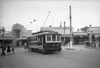 Ballarat Tramway Museum
Negative, Wal Jack, late 1930's
Yields information about Ballarat 's tram operations and Stones Corner.Negative and Digital image of the Wal Jack Ballarat Negative file of No. 17 loading passengers at Stones Corner, the intersection of Victoria St and Main St. A Caltex service station is on the right hand side and the State Savings Bank of Victoria. trams, tramways, victoria st, bridge st, main st, stones corner, tram 17 -
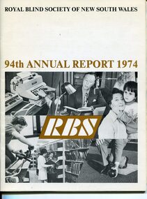 Vision Australia
Administrative record - Text, 94th Annual Report Royal Blind Society of N.S.W. (1974), 1974
Articles in the annual report include: death of General Manager Ian Burnet, expenditure exceeding income, need to sell Woolahra (Helen Keller hostel) property, goal of opening 20 new Day centres by the end of 1975, plans to establish Occupational Therapy Training unit, review of aging hostels and restructure workshop, growth of Mitchell Street Theatre, increase of children with more than sight loss at nursery, decision to establish reading competition in memorial to Barbara Rutherford and awarding of Churchill Fellowship to Joan Ledermann for a review of Braille production units overseas.1 volume of text and imagesroyal blind society of new south wales, corporation records -
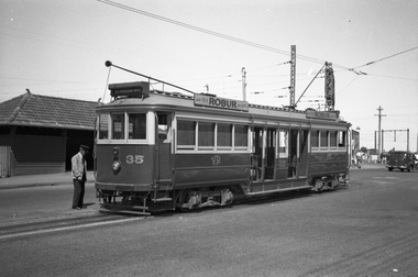 Melbourne Tram Museum
Negative - Set of 2, Wal Jack, 27/12/1939 12:00:00 AM
Set of two Black and white negatives of Victorian Railways tram 35 at the Brighton Station terminus - 27-12-1939. Tram has adverts for Robur tea. .1 - has the Motorman looking at the bogie. In the background is the waiting shelter at the terminus and an advert for Dandy Ham - get on for Christmas. Photo in the Wal Jack Victorian Railways Album which provides the date.trams, tramways, victorian railways, vr trams, brighton, motormen, tram 35 -
 Kew Historical Society Inc
Plan - Subdivision Plan, Normanby Estate, East Kew, 1913
Pru Sanderson, in her groundbreaking ‘City of Kew Urban Conservation Study : Volume 2 - Development History’ (1988), summarised the periods of urban development and subdivisions of land in Kew. The periods that she identified included 1845-1880, 1880-1893, 1893-1921, 1921-1933, 1933-1943, and Post-War Development. These periods were selected as they represented periods of rapid growth or decline in urban development. An obvious starting point for Sanderson’s groupings involved population growth and the associated economic cycles. These cycles also highlighted urban expansion onto land that was predominantly rural, although in other cases it represented the decline and breakup of large estates. A number of the plans in the Kew Historical Society’s collection can also be found in other collections, such as those of the State Library of Victoria and the Boroondara Library Service. A number are however unique to the collection.The Kew Historical Society collection includes almost 100 subdivision plans pertaining to suburbs of the City of Melbourne. Most of these are of Kew, Kew East or Studley Park, although a smaller number are plans of Camberwell, Deepdene, Balwyn and Hawthorn. It is believed that the majority of the plans were gifted to the Society by persons connected with the real estate firm - J. R. Mathers and McMillan, 136 Cotham Road, Kew. The Plans in the collection are rarely in pristine form, being working plans on which the agent would write notes and record lots sold and the prices of these. The subdivision plans are historically significant examples of the growth of urban Melbourne from the beginning of the 20th Century up until the 1980s. A number of the plans are double-sided and often include a photograph on the reverse. The Normanby Estate, which was adjacent to Normanby Road, Kew East, included thirty-one lots for sale. Streets on the subdivision plan include Adeney Avenue, Park Hill Road, Normanby Road, Weir Street and Wharton Street. Cotham Road and its tramway are shown nearby. The plan is interesting as it shows Wharton Street, named after the architect and town planner George Wharton, who was the first chairman of the Municipality of Kew. The street was to later be renamed Cecil Street. Also shown are proposed ‘Municipal Gardens’ where Parkhill Drive is now located.subdivision plans - kew, normanby estate -
University of Melbourne, Burnley Campus Archives
Plan, Landscape Construction I Paving on Mortar, 1990-2000
Plan of paving construction. Fall to Grade. Scale 1:20.landscape construction, paving -
Vision Australia
Administrative record - Text, The Association for the Blind Illawarra Community Centre manager reports 7/11/1978 to 6/6/1993, 1978-1993
The Manager reports are a general overview of the activities, programs, statistics, personnel, policies, repairs, volunteers and updates of the Illawarra Community Centre. The newsletter from Geelong Branch committee is also been included. 3/9/1979 it was reported that after receiving written permission the Geelong Advertiser, sections of the paper have been recorded onto cassette, on a weekly basis, and made available to low vision members. 7/7/1980 it was reported that a detailed scale model of Illawarra has been constructed as an aid to assist visually and other handicapped members to become orientated to the Centre. 1 paper register of handwritten notesassociation for the blind, illawarra community centre -
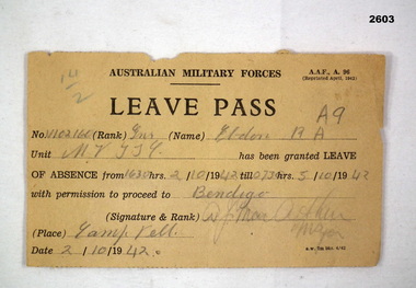 Bendigo Military Museum
Administrative record - LEAVE PASS WW2, 1942
Leave Pass A.A.F., A. 96, paper, black print, hand written in pencil."No 11102 Rank: GNR (Gunner) Eldon RA (A9) Unit: M7 TT9 Absent: 1630 2.10.42 - 0730 5.10.42 To: Bendigo Signature: MAJOR A F MACARTHUR (2.10.42)"documents - licences, military history, leave, passchendaele barracks trust -
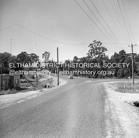 Eltham District Historical Society Inc
Negative - Photograph, J.A. McDonald, Heidelberg-Kinglake Road, Mar. 1960
Completed junction Looking north March 1960 Job 56M411Record of various Shire of Eltham infrastructure works undertaken during the period of 1952-1962 involving bridge and road reconstruction projects, sometimes with Eltham Shire Council Project Reference numbers quoted. It was during this period that a number of significant improvements were made to roads and new bridges constructed within the shire that remain in place as of present day (2022). In many situations, the photos provide a tangible visible record of infrastructure that existed throughout the early days of the Shire. The album was put together by or under the direction of the Shire Engineer, J.A. McDonald.infrastructure, 1960-03, bridge construction, cherry tree road, heidelberg-kinglake road, road construction, shire of eltham -
 Heidelberg Golf Club
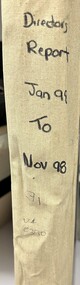
Administrative record - Reports, Heidelberg Golf Club, Directors' Reports (Board Papers): Book 31: January 1998 - November 1998, 1998
Typed reports to Directors of Heidelberg Golf Club from the various sub committees: January 1998 - November 1998. Internal title now "Board Papers"Volume 31 of a set of reports to Directors. Cardboard cover with cream spine binding, multiple pages, unnumbered. committee reports, directors' reports, board papers -
Bialik College
Plan (item) - Bialik College, 1970s
Two boxes of architectural plans of proposed Bialik College, 429 Auburn Road, Hawthorn East, created by architects Joshua and Mary Pila, c. 1970s. Box 1: 1970s, Box 2: 1979. Please contact [email protected] to request access to this record.1970s, building and planning -
 Federation University Historical Collection
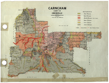
Plan, Carngham, County of Grenville
A plan of Carngham, Victoria.snake valley, timber reserve, poverty point, recreation reserve, carngham, county of ripon, county of grenville, plan -
 Melbourne Tram Museum
Negative, Ellis Collection, 1930s
Negative (120) of a Grip car body in a park with a family sitting on the tram. Could be the Ellis family. Caption to donation sheet says Edwards Lake, Reservoir late 1930's. See image htd3621i1 and i2 for an image of Inspector Ellis.trams, tramways, cable trams, edwards lake, grip tram, reservoir, tram 394? -
 Eltham District Historical Society Inc
Negative - Photograph, Open Day, Eltham Living and Learning Centre, 7 Nov 1987
Open Day, Eltham Living and Learning Centre, part of the Eltham Community Festival activites, 7 Nov. 1987eltham, eltham festival, eltham living and learning centre, living and learning centre, open day -
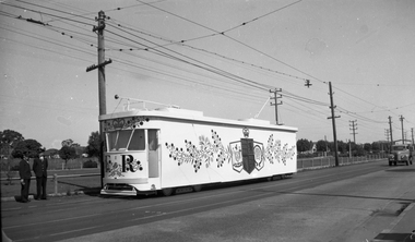 Melbourne Tram Museum
Negative, Wal Jack, 1954
Black and white negative, by Wal Jack, of PCC 980 decorated as the Royal Tram at the time of the Royal Visit to Victoria during 1954. Photographed in St Georges Road. The tram crew are standing in front of the tram.trams, tramways, royal visit, st georges road, crews, tram 980, pcc class, mmtb -
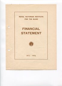 Vision Australia
Administrative record - Text, RVIB Financial Statement 1975-1976
Financial information for the Royal Victorian Institute for the Blind, presented as an appendix to the annual report of the institution.1 printed volume of financial information for the RVIBroyal victorian institute for the blind, annual reports -
Federation University Historical Collection
Plan, School of Mines Ballarat
Watercolor architectural drawing on paper depicting the Ballarat School of Mineslower left corner "Drawn by H.L Coburn: 1915"coburn, architecture, ballarat school of mines, plan -
 Kew Historical Society Inc
Plan - Subdivision Plan, Erin Heights Estate, East kew, 1917
Pru Sanderson, in her groundbreaking ‘City of Kew Urban Conservation Study : Volume 2 - Development History’ (1988), summarised the periods of urban development and subdivisions of land in Kew. The periods that she identified included 1845-1880, 1880-1893, 1893-1921, 1921-1933, 1933-1943, and Post-War Development. These periods were selected as they represented periods of rapid growth or decline in urban development. An obvious starting point for Sanderson’s groupings involved population growth and the associated economic cycles. These cycles also highlighted urban expansion onto land that was predominantly rural, although in other cases it represented the decline and breakup of large estates. A number of the plans in the Kew Historical Society’s collection can also be found in other collections, such as those of the State Library of Victoria and the Boroondara Library Service. A number are however unique to the collection.The Kew Historical Society collection includes almost 100 subdivision plans pertaining to suburbs of the City of Melbourne. Most of these are of Kew, Kew East or Studley Park, although a smaller number are plans of Camberwell, Deepdene, Balwyn and Hawthorn. It is believed that the majority of the plans were gifted to the Society by persons connected with the real estate firm - J. R. Mathers and McMillan, 136 Cotham Road, Kew. The Plans in the collection are rarely in pristine form, being working plans on which the agent would write notes and record lots sold and the prices of these. The subdivision plans are historically significant examples of the growth of urban Melbourne from the beginning of the 20th Century up until the 1980s. A number of the plans are double-sided and often include a photograph on the reverse. A number of the latter are by noted photographers such as J.E. Barnes.The Erin Heights Estate in Kew included just seven lots in in Valerie Street. These were all that remained of this wartime subdivision, the other 11 allotments on Balfour and Belford Roads having already been sold. Balfour Road was to be only a temporary name as the street is currently called Windella Avenue. Now, the parkland opposite the subdivision is the reserve created from the route of the Outer Circle Railway. This Railway reached Kew East in 1925, but had been planned as far back as 1873. The development focuses on the benefits of living in Kew: being at the highest of Kew’s ‘suburbs’; being a good residential area; its rapid growth; and the proximity of the Kew East tram in High Street. In 1917, the electric tramline only extended to a terminus at the Harp of Erin hotel. The terminus is clearly represented on the plan.subdivision plans - east kew, erin heights estate -
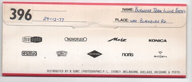 Melbourne Tram Museum
Negative, Bruce Herbert, "Burwood Tram Line Extns - near Blackburn Road", 29/12/1977 12:00:00 AM
Negative folder - made by SAGA Japan, containing 6 no. 120 film negatives 60mm x 90mm of the works on the extension to East Burwood, Burwood Highway, near Blackburn Road, 29-12-1977. Folder stamped 396 .1 - Burwood highway - out of focus - showing end of slab. .2 - ditto - looking west? - shows cross section of slab. .3 - Blackburn road with poles positioned - with BP service station in background. .4 - ditto .5 - sign showing tramway works in progress .6 - from the kerbside showing the track.trams, tramways, burwood highway, tramway construction, construction, east burwood -
 Ballarat Tramway Museum
Negative - Brill 22E bogie or truck - Geelong tramcar, early 1956
Photo shows Brill 22E Maximum Traction bogie or truck - Geelong tramcar, has the SEC logo on the side of the tramcar in the view. One of a set of photos was taken between 15/2/1956 and 3/3/1956 when services operated only between Belmont and North before the final closure of the Belmont route on 25/31956 and that bogie tram 31 is not shown on the board, having gone to Ballarat on 15/2/1956 - see item 5554. See item 8213 for an article on the Geelong system by Keith Kings. Yields information about the Geelong bogie trams.Black and white Negative - 120 sizetramways, geelong, brill 22e, maximum traction, bogie trams -
University of Melbourne, Burnley Campus Archives
Negative - Collur negatives, Plant Materials, 1998
Photographs of plants for Plant Materials 3. Negatives only. Degree/Diploma Year 2 Semester 1 Plant Materials 3 Weeks 1-6, 10-13. Plant Materials 3 1998 Weeks 2-5, 8-10.plants, plant materials, 1998, degree/diploma 2 -
Moorabbin Air Museum
Plan (item) - Bristol Aeroplane 170 schematic drawings, Access Door Trailing Edge Top Compi Centre Plane
Bristol Aeroplane Company Ltd -
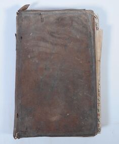 Bendigo Historical Society Inc.
Administrative record - Account Book, 1859
The purchases and services recorded indicate that the user was an ironmonger. Origin of ledger unknown. Early business in Sandhurst in 1860s.An account ledger used to record the purchases and services made for a business. Records date from 1860. The ledger is covered with brown leather with decorative edges. There are alphabetical tabs at the front of the book with lists of names. Individual customers are allocated a double page entry. Pages are ruled and numbered. The book is in very poor condition having obvious signs of water and insect damage. The writing in the first quarter of the book is barely legible, remaining pages can be read. Some names - Durant, Watson, Mollison, Harris, Neale, Cahley, Bannerman, Larritt, Cranshaw, Gripe, McLachlan, Burrell, O'Loughlin, Cameron Rogers, McLevey, Nicholas Eliad?, Crago, Hopsell, Grant, Bird, Cahill, Harker, Parker S McKinlay, Fletcher, Birch, Cruikshank, Municipal Council, Heffernan and Crawley, Buckley Bros, John Harney, Bywater and Brother, Goulding, Casey, Reynolds English, McKenzie, Knight, David Mackay."LEDGER" on the spine. Label inside "Sands and Kenny. Account Book Manufacturers. Stationers and Printers Melbourne"bendigo businesses, ironmonger -
University of Melbourne, Burnley Campus Archives
Negative - Colour negatives, Plant Materials
8 rolls negativesLabelled, "Diploma/Degree Semester 2 Weeks 6-13." "Weeds, Australian Plants, Climbing Plants & Ground Covers, Early Spring Flowering Plants, Californian Plants & Others, Plants for De Oxygenated Soils, Aquatic Plants, Botanical Gardens (Rarer Plants)." Not digitised.plant materials, weeds, australian plants, climbing plants, ground covers, early spring flowering plants, californian plants, deoxygenated soils, aquatic plants, botanical gardens, rare plants, degree, diploma -
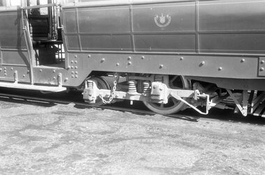
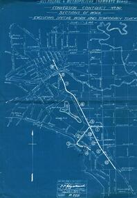 Melbourne Tram Museum
Administrative record - Contract bid documents, Melbourne & Metropolitan Tramways Board (MMTB), "Conversion Contract No. 361 - Sections of Work - Excluding Special Work and Temporary Tracks", Jul. 1925
.1 - Drawing - blueprint No. P2231 titled "Conversion Contract No. 361 - Sections of Work - Excluding Special Work and Temporary Tracks", showing the order of work to convert the cable tramway in Swanston St and St Kilda Road and associated services to Electric trams. Dated 1-7-1925. .2 - MMTB Schedule for the above drawing showing section number, street name, From To, Length in feet and Type of track. Has more sections than that shown on the drawing.Sheet 2 of .2 has file number stamped P/9/2.trams, tramways, cable trams, trackwork, conversion, st kilda rd, swanston st, contracts -
Port Melbourne Historical & Preservation Society
Plan - Detail of Grille and Stairs, Port Melbourne Town Hall, Port Melbourne City Council, 1916
Plan - Details of grille to entrance and over main stair, details of main stairs. (1915 Town Hall)port melbourne town hall -
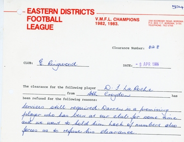 Ringwood and District Historical Society
Administrative record, East Ringwood Football Club (ERFC) 1986 Clearance Records
A number of A4 sheets detailing individual 1986 clearances, part a