-
 Kew Historical Society Inc
Administrative record - Document, Auburn Heights Men's Bowling Club Minute Book 1978-82, 1978-1982
Sports Clubs in Kew in the final decades of the 19th century and in the early 20th century were often umbrella organisations with facilities for a number of sports. Typically in Kew, this included teams in lawn bowls, tennis and croquet. The Kew Bowling Club was formed in 1880 while the privately owned Auburn Heights Recreation Club was opened in 1904. By 1998, the two Clubs decided to amalgamate at the Auburn Heights site in Barkers Road, forming the Kew Heights Sports Club. The combined club was itself taken over by the Melbourne Cricket Club in 2012 becoming MCC Kew Sports Club. In 2017 MCC Kew closed and its landholding was subsequently sold to Carey Baptist Grammar School. Both the Kew and Auburn Heights Clubs assembled important collections. These historically significant and large collections were donated to the Society in 2020. The collections include manuscripts, pictures, trophies, plans, honour boards etc. References Barnard FGA 1910, 'Sports and Pastimes' in Jubilee History of Kew Victoria: Its origin & progress 1803-1910. Chapman J & C 1999, The history of the Auburn Heights Recreation Club, 1904 to 1908. Reeve S 2012, City of Boroondara: Thematic Environmental History, p.216.The combined collections of the four sporting clubs making up the collection number hundreds of items that are historically significant locally. They are also significant to the sporting history of the greater Melbourne area and to the sports of lawn bowls and tennis in Australia in the 19th and 20th centuries. The collection illuminates two of the Victorian historic themes - 'Building community life' through forming community organisations and 'Shaping cultural and creative life' by participating in sport and recreation.Bound Minute Book of the Auburn Heights Men's Bowling Club covering the period 1978 to 1982. [The item forms part of the large historic Auburn Heights Recreation Club collection, with items relating to the sports of lawn bowls, tennis and croquet, gifted to the Kew Historical Society in 2020].auburn heights men's bowling club - barkers road - kew (vic), auburn heights men's bowling club - minute books -
 Port Melbourne Historical & Preservation Society
Plan - Walter Avenue, Port Melbourne, Town of Port Melbourne, 1893 - 1919
Plan of Walter Avenue showing various cross sections, date unknown.engineering - roads streets lanes and footpaths, walter avenue, loans program -
Lakes Entrance Regional Historical Society (operating as Lakes Entrance History Centre & Museum)
Administrative Record - Ledger, Lindenow Pence Book, 16923
Entries are hand written in ink, 90 pages have been used, which is approximately 1/3 of total capacity, a number of loose Hospital Fund dockets inside rear cover, leather bound with heavy cardboard cover, approx 270 pagesA bound Ledger containing accounting / membership details for the Loyal Lindenow Lodge of Manchester Unity Independent Order of Oddfellows (MUIOOF)accounts book -
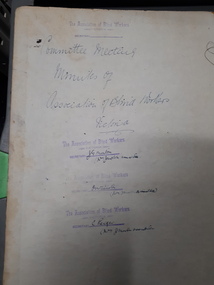
 Vision Australia
Administrative record - Text, The Association for the Blind, Blind Members' Council meeting minutes 24/2/1986 to 25/9/91, 1986-1991
These meetings were held at the Kooyong office and the minutes include Present, Chair, Apologies, Minutes, Matter arising from minutes, Correspondence, Life governors, Election of members, Nominations, Reports from Regional Blind Members groups. Some highlights include: 27/10/1986 it was reported that tactile maps of the Melbourne Metropolitan Railway network are now available. 6/2/1987 as special meeting had been called to discuss in detail what action should be taken regarding the proposed $2 coin. John Cook advised that BMC had been invited to send a representative to Canberra to meet with other Blind consumers and representatives from the Mint and Treasury. The BMC agreed the coins needed further testing. 29/2/1988 The Treasury received further letters regarding the $2.00 coin. It was agreed this matter could not be pursued any further. 26/11/1990 it was reported that the commissioned by BMC of the Association's founder Miss Tilly Aston, was officially unveiled by Mrs Jean Ross and Mrs Diana Jones at the 95th Birthday Celebration Concert. The portrait was then hung in the foyer of the Vision Resource Centre. Suitably framed photographs of the founder's portrait to be circulated to all branches. The visits to primary schools by BMC members continued as part of the School's program as did the BMC radio program on 3RPH. Minute book for Blind Members Councilassociation for the blind, blind members council -
 Bendigo Historical Society Inc.
Map - JACK FLYNN COLLECTION: BEALIBA, 15/09/1931
Map: Parish of Bealiba, County of Gladstone. Parish plan.By Authority H.J. Green, Government Printer. Photo Lithographed at the Government of Lands and Survey Melbourne. 15.9.31map, gladstone, parish plan, bealiba, gladstone -
 Kew Historical Society Inc
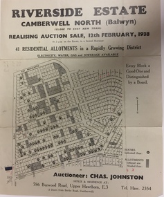
Plan - Subdivision Plan, Riverside Estate, Camberwell North (Balwyn), 1938, 1939
This subdivision known as the Riverside Estate wa sone of the largest and most significant in Balwyn's history.Subdivision Plan for 41 lots within the wider Riverside Estate in Camberwell North, now Balwyn, in February 1938. The auction featured lots in Burke Road, The Boulevard, Mt View Road, Wattle Avenue, Kyora Parade, Cascade Street, Riverside Avenue, Walbundry Avenue, Inverness Way, Bulleen Road and Doncaster Road.Allotments for sale are shaded grey on the map. Certain lots have an H in a circle. These are presumably where houses had already been constructed.subdivision plans - balwyn (vic), riverside estate - balwyn (vic) -
 Federation University Historical Collection
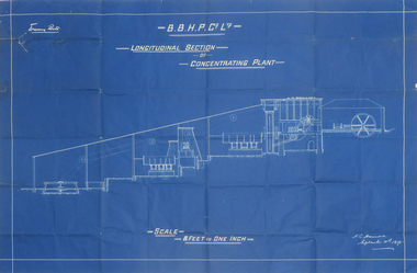
Plan, Blueprint B.B.H.P. Co Ltd Longitudinal Section of Concentrating Plant, 1895
Blueprint plan by H.L. Hancock blueprint, h. l. hancock, longitudinal section, concentrating plant, bhp -
Port Melbourne Historical & Preservation Society
Plan - Drainage works, cnr Crockford and Raglan Streets, Sandridge, George Kelly, Borough Surveyor, 6 Jun 1864
Ground plan for drainage work after flood 1864. Corner Crockford Street and Raglan Street.Borough of Sandridgeengineering department - borough of sandridge, engineering - canals and drainage, hotels, george kelly -
Port Melbourne Historical & Preservation Society
Plan - Main drain, west branch, Evans Street to Esplanade East, Port Melbourne, 14 Mar 1893
Plan of main drain west branch, from Evans Street to Esplanade East (together with written specifications attached - refer 75.1) 1893.J.J. Bartlett (Mayor) 14/3/93engineering - canals and drainage, arthur victor heath, town clerks, james john bartlett, mayors -
Whitehorse Historical Society Inc.
Map, Burwood Road, Box Hill City, 1952
Country Roads Board survey of Burwood Road, Burwood between Central Avenue and Elgar Road. Includes details of fencing, nature of buildings. With penciled additions to 1957.Country Roads Board survey of Burwood Road, Burwood between Central Avenue and Elgar Road. Includes details of fencing, nature of buildings. With penciled additions to 1957.Country Roads Board survey of Burwood Road, Burwood between Central Avenue and Elgar Road. Includes details of fencing, nature of buildings. With penciled additions to 1957.maps, burwood road, burwood, parer street, elgar road, cromwell street, ireland street, central avenue burwood, scott grove, somers street, gilmour street, evans street, edwards street, mills road -
Moorabbin Air Museum
Plan (Item) - Drawing Exterior Finishing Scheme Orion P3-B Aircraft , Drawing A16194, Sheet 1 Of 5 Sheets
-
Canterbury History Group
Map - Maling Road Built form Map, Ciy of Boroondara, 2015
Map copied from the 'Urban Planning Special Committee Agenda' Design and Development Overlay- Schedule 23 showing heritage property on Maling Road. Produced by The City of Boroondaracanterbury, maling road, heritage buildings, city of boroondara, urban planning special committee agenda, maps -
Stawell Historical Society Inc
Map, Stawell Joint Venture, Map of Stawell showing Mining Lease Boundary and Freehold Land, September 1988
Stawell Joint Venturemining, gold, map -
Glenelg Shire Council Cultural Collection
Administrative record - DVD - DVD - Material copied from the Port of Portland collection of 16mm films, Noel Waugh, Disc 5 - Building the Port of Portland during the 1950s and 60s, 2010
Port of Portland CollectionFront: DVD 'Disc 5 Duration 58 mins'port of portland -
Glen Eira Historical Society
Map - Kilvington Baptist Girls Grammar School
One hard copy and one photocopy of Kilvington Baptist Girls Grammar School Planning brief dated October 1982. The brief details the current needs of the school and has been written to spell out a forward plan for development in the foreseeable future. It includes data on the current forecast enrolments at primary and secondary levels as well as the current and future use and development of the buildings and their use. Author of the brief is unknown.kilvington baptist girls grammar school, schools, ormond, lillimur road, walsh street, ormond girls school, kilvington girls grammar school, leila road, katandra road, ulupna road -
 Kew Historical Society Inc
Plan, Borough of Kew Detail Plan No.1577, 1904
The Melbourne and Metropolitan Board of Works (MMBW) plans were produced from the 1890s to the 1950s. They were crucial to the design and development of Melbourne's sewerage and drainage system. The plans, at a scale of 40 feet to 1 inch (1:480), provide a detailed historical record of Melbourne streetscapes and environmental features. Each plan covers one or two street blocks (roughly six streets), showing details of buildings, including garden layouts and ownership boundaries, and features such as laneways, drains, bridges, parks, municipal boundaries and other prominent landmarks as they existed at the time each plan was produced. (Source: State Library of Victoria)This plan forms part of a large group of MMBW plans and maps that was donated to the Society by the Mr Poulter, City Engineer of the City of Kew in 1989. Within this collection, thirty-five hand-coloured plans, backed with linen, are of statewide significance as they include annotations that provide details of construction materials used in buildings in the first decade of the 20th century as well as additional information about land ownership and usage. The copies in the Public Record Office Victoria and the State Library of Victoria are monochrome versions which do not denote building materials so that the maps in this collection are invaluable and unique tools for researchers and heritage consultants. A number of the plans are not held in the collection of the State Library of Victoria so they have the additional attribute of rarity.Original survey plan, issued by the MMBW to a contractor with responsibility for constructing sewers in the area identified on the plan within the Borough of Kew. The plan was at some stage hand-coloured, possibly by the contractor, but more likely by officers working in the Engineering Department of the Borough and later Town, then City of Kew. The hand-coloured sections of buildings on the plan were used to denote masonry or brick constructions (pink), weatherboard constructions (yellow), and public buildings (grey). MMBW Plan No.1577 includes some of the most significant houses in Kew: Herbert Henty’s ‘Roxeth’ (now part of Trinity Grammar), ‘Butleigh Wooton’, ‘Bokara’ and ‘Harrow’. It also includes the streets that have since changed their names. That part of College Parade linked to Glenferrie Road is now named College Place, College Parade now extends further north, and Charles Street did not yet reach Barkers Road. Roxeth is one of a number of Henty houses in Kew. Herbert Henty made his home here and was elected a member of Kew Municipal Council in 1864 and mayor in 1868-69. Walter Henry Serle, of Harrow served in the First World War. He was awarded the Military Medal ‘’For conspicuous bravery and devotion to duty. On 29th September near BELLICOURT he showed the greatest bravery and determination when his platoon was attacked by enemy bombing parties. It was due largely to his personal efforts that all the attacks were repulsed. Until wounded, his utter disregard of personal safety and boldness in dealing with the attacks were the means of saving the situation and were an inspiring example to his men.’melbourne and metropolitan board of works, detail plans, maps - borough of kew, mmbw 1577, cartography -
 Vision Australia
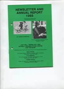
Administrative record - Text, Newsletter and Annual Report 1985 Lady Nell "Seeing Eye" Dog School & Rehabilitation Centre for the Blind, 1985
President's overview of the year including: the beginnings of the school at Wonga Park, Arthur McKay being the first person to receive a dog, the scarcity of funds after training the first dog and the joy of receiving the first substantial donation from the Sunshine Foundation Trust, opposition from some quarters, Kim Gration and Dennis Gration involvement with the school, the work of Pat Mallaney in Tasmania, support and assistance from vet Dr Rowan Blogg, opening the activity centre in 1962, seeing eye dog trainer Judy Oakenfell, the sale of Wonga Park and transfer to Malvern, threats to dismiss Harold Gration working due to involvement with the school, overview of growth of Queensland branch, working with Jeff Mowat who developed the Mowatt sensor, training of people around Australia and from New Zealand, return of 'Stacey' from Singapore due to not being accepted on public transport, restaurants, etc, diverse age range of people trained, less people volunteering, loss of 3 auxiliaries due to lack of members, and opening of shop and welfare centre in Cairns.1 volume with text and illustrationsannual reports, lady nell seeing eye dog school, phyllis gration -
 Melbourne Tram Museum
Administrative record - Depot List, Melbourne & Metropolitan Tramways Board (MMTB), "MMTB Depot List", 28/02/2015 12:00:00 AM
Digital image of a set of 8 different MMTB depot tramcar fleet lists in various formats. .1 - 1923 - at 1/2/1923 - "Stock sheet" - two pages - see image files htd1923p1 and htd1923p2. .2 - 1938 - at 30/6/1938 - "MMTB Car Allocation list" - 5 pages - see htd1938p1 to htd1938p5. .3 - 1952 - at 27/12/1952 - "Allocation of cars at end of period" - 2 pages - see htd1952p1 and htd1952p2. .4 - 1958 - at 30/8/1958 - "Allocation of cars at end of period" - 2 pages - see htd1958p1 and htd1958p2. .5 - 1971 - at January 1971 - "Allocation of tramcars" - 2 pages - see htd1971p1 and htd1971p2. .6 - 1972 - at 1/1/1972 - "Allocation of tramcars" - 2 pages - see htd1972p1 and htd1972p2. .7 - 1974 - at 1/1/1974 - "Allocation of tramcars" - 2 pages - see htd1974p1 and htd1974p2. .8 - 1981 - at 1/7/1981 - "Allocation of tramcars - both in numerical order and depot allocation" - 9 pages - see htd1981p1 to htd1981p9. .9 - Actual copy of the .6 - 1/1/1972 - "Allocation of tramcars - both in numerical order and depot allocation" - see image htd824i9.pdf Added 17/1/2019. .10 - Actual copy of .5 - 1/1/1971 - Added 17/1/2019. .11 - Actual copy of .7 - 1/1/1974 - added 13/5/2019 .12 - "Allocation of tramcars in Numerical Order as at 1/1/74" added 13/5/2019 as images htd1974a.pdftrams, tramways, tramcars, mmtb, lists, depots, depot allocation -
 Bendigo Historical Society Inc.
Administrative record - Kangaroo Flat Red Cross Collection: General meeting minute book. April 1973 to August 1987
Red cover with gold embossed inscription. Lined pages inside with handwritten notes. Kangaroo Flat Red Cross Minute book containing minutes of general meetings held monthly at various halls. Kangaroo Flat Branch of the Australian Red Cross Society Victorian division.Inside front cover and inside back cover each have two small sticky tape marks. 7 blue pen marks on calendar inside back cover. One blue pen mark near spine on inside front cover.kangaroo flat, red cross, minutes -
 Ringwood and District Historical Society
Map, Proposed Subdivision - Hilltop Estate, Heathmont, Victoria - circa 1925
Plan of Part of Crown Allotments 16 & 18, Parish of Ringwood, County of Mornington. Subdivision includes Site for Heathmont Station, Heathmont Road, George Street, Lilian Street, Edith Street, Edna Street, Great Ryrie Street. Inset locality plan also shows nearby Electric Railway Estate and Heathmont Station Estate. L.H. Webber, Licensed Surveyor, 440 Little Collins Street, Melbourne. -
 Vision Australia
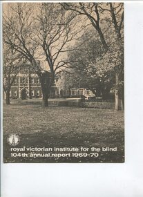
Administrative record - Text, Royal Victorian Institute for the Blind 104th annual report 1969-1970, 1969-1970
Articles in annual report include: List of RVIB president, vice president, board of management, medical staff and officers of the institute, honorary officers and consultant medical staff, The president's report, Nursery and school, Employment - the means of independence, Training and rehabilitation centre the rebirth of confidence and skills, Multi handicapped children, Our senior blind citizens the aged are not forgotten, Finance, Our auxiliaries and other helpers, Welfare -an increasing need, Melbourne traditional carols by candlelight, Services and facilities, When you make or amend your will. Events that occurred in 1969 : Alexander Mair died, he was a member of the board of management since 1952, RVIB faced a deficit, to date they did not have to restrict the scope of any of the services available to blind people and it was hoped with increasing support from all sections of the community that they would not have to do so, after 31 continuous years radio station 3KZ decided to discontinue its association with the Melbourne traditional Christmas festival carols by candlelight but in doing so offered the RVIB the rights to continue. It was the first time RVIB hosted and they offered thanks to television channel 0 and radio station 3AW.1 volume of printed text with photographsroyal victorian institute for the blind, annual reports -
Bendigo Historical Society Inc.
Map - NERRING SHEET 4, Circa 1890's
Map: Nerring (part 4) . Parish plan ( number 189 in Map Cupboard 1)map, bendigo, parish plan, nerring -
Port Melbourne Historical & Preservation Society
Plan - Williamstown Road from Farrell Street to Derham Street, Engineering Department, Town of Port Melbourne, 1893 - 1919
Plan of Williamstown Road, from Farrell Street to Derham Street. Loan No.5.engineering - roads streets lanes and footpaths -
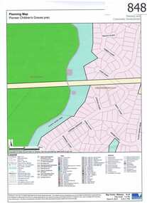 Greensborough Historical Society
Map, Plenty River Children's Cemetery - location map, 1848-1860
The unmarked graves of the children of two Greensborough pioneer families lie in a private cemetery on the Plenty River. Burials occurred between 1848 and 1860.The significance lies in the association with two of the pioneer families of the Greensborough district. Descendants of both families still live in the area.One page map accompanies article item #804 -
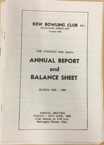 Kew Historical Society Inc
Administrative record - Annual Report, Kew Bowling Club One Hundred & Ninth Annual Report and Balance Sheet, Season 1988-9, 1988-1989
Sports Clubs in Kew in the final decades of the 19th century and in the early 20th century were often umbrella organisations with facilities for a number of sports. Typically in Kew, this included teams in lawn bowls, tennis and croquet. The Kew Bowling Club was formed in 1880 while the privately owned Auburn Heights Recreation Club was opened in 1904. By 1998, the two Clubs decided to amalgamate at the Auburn Heights site in Barkers Road, forming the Kew Heights Sports Club. The combined club was itself taken over by the Melbourne Cricket Club in 2012 becoming MCC Kew Sports Club. In 2017 MCC Kew closed and its landholding was subsequently sold to Carey Baptist Grammar School. Both the Kew and Auburn Heights Clubs assembled important collections. These historically significant and large collections were donated to the Society in 2020. The collections include manuscripts, pictures, trophies, plans, honour boards etc. References Barnard FGA 1910, 'Sports and Pastimes' in Jubilee History of Kew Victoria: Its origin & progress 1803-1910. Nixon NV 1980, The History of the Kew Bowling Club 1880-1980. Reeve S 2012, City of Boroondara: Thematic Environmental History, p.216.The combined collections of the four sporting clubs making up the collection number hundreds of items that are historically significant locally. They are also significant to the sporting history of the greater Melbourne area and to the sports of lawn bowls and tennis in Australia in the 19th and 20th centuries. The collection illuminates two of the Victorian historic themes - 'Building community life' through forming community organisations and 'Shaping cultural and creative life' by participating in sport and recreation.One Hundred & Ninth Annual Report and Balance Sheet, Season 1988-9. [The item is part of the large historic Kew Bowling Club collection (1880-1988) gifted to the Kew Historical Society in 2020].kew bowling club - wellington street - kew (vic), clubs - lawn bowls - kew (vic), annual reports -
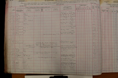 Ringwood and District Historical Society
Administrative record - Rate Books, Borough of Ringwood Valuation & Rate Book for 1924 (Assessments 2581-2780), March 2012
Originally stored at Ringwood Council offices, then taken to PROV.Only source of ratepayers in the Borough of RingwoodDigital images -
Port Melbourne Historical & Preservation Society
Map - Chart, Port Phillip, 1930
Photocopy in two large sections, of soundings chart for Port Phillip Bay, surveyed by Commander Henry L Cox RN, 1864, with corrections and additions to 1921. Lower section.(Original had stamp of John Donne & Son Stationers)transport - shipping, port phillip bay -
Bendigo Historical Society Inc.
Map - MAP PORTION OF BENDIGO GOLDFIELD, Circa 1912
Map: Portion of Bendigo Goldfield showing Sheepshead, Deborah, Garden Gully, Paddy's Gully and Derby lines of reef. Showing statistical records of all the Companies on these lines. Issued by Wood and McNair, Sharebrokers, Bendigo and Eaglehawk. The map illustrates the main lines of reef as they appeared with mines and details of their calls and dividends as well as gold produced. Drawn by mining surveyor and geologist William Henry Cundy, who trained and worked for the Tasmanian Mines Department until 1893, when he moved and settled in Bendigo. Cundy was responsible for the surveying of the southern end of the field of Diamond Hill and beyond.topic, mining, companies, bendigo goldfield, sheepshead , deborah, garden gully, paddy's gully derby, wood and mcnair -
 Vision Australia
Administrative record - Text, Association of Victorian Blind Workers Committee: 7/6/1931 - 25/1/1940, 1931-1940
These minutes include Present, Apologies, Correspondence, Registrations, Reports and Interviews with workers. 16/12/1938 it was noted the Secretary created a brochure called 'Social Justice for the Blind' and other publications for promotion of the organisation. It was also reported re the Institutions decision to pay Christmas pay on the basis of Married pensioners, £3-7-6, Married non-pensioners £4-7-6 per week and single men £2-2-6 per week. The child allowance has been discontinued. Meetings were often held in private homes or in spaces provided by churches.1 volume of handwritten notesassociation of victorian blind workers, royal victorian institute for the blind -
Bendigo Historical Society Inc.
Map - SHEEPSHEAD LINE OF REEF, Circa 1940's
Map: Plan showing a Longitudinal section of the Sheepshead line of Reefs , Bendigo. (34 Copies)map, bendigo, mining plan, sheepshead line of reef, gold mines , mining