-
 Moorabbin Air Museum
Plan (item) - Bristol Aeroplane 170 schematic drawings, Access Door- Top Skin At Rear Spar Outer Wing
Bristol Aeroplane Company Ltd -
 Melbourne Tram Museum
Administrative record - Depot Table Sheet or Block, The Met, "North Fitzroy - Basic Holiday", Apr. 1984
Depot table sheet - spirit duplicated - for Basic Holidays - Anzac Day 25-4-1984 - Kew Depot - shows the various runs and crew tables for the day, has an index and notes.trams, tramways, table cards, north fitzroy depot, drivers, anzac -
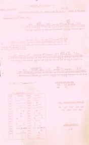
 Mission to Seafarers Victoria
Administrative record (Item) - Cash and Minute Book, Sailors' Rest Cash and Minute Book 1878, c. 1878
Minutes of the Williamstown committee of the Sailors' Rest created in 1878, and open on 24 May 1878. At the end, the pages also contains a list of books in the library of the Sailors' Rest and names of borrowers.sailors' rest, williamstown, sir william stawell, j. john halley, john courtis, library, books, minutes books -
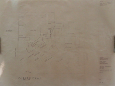 Federation University Historical Collection
Plan, Ballarat School of Mines Schematic Proposal for the Former Ballarat Brewery Site
The Project Manager for the Ballarat School of Mines Brewery Building was Peter Davies. The plan suggests the closure of Lydiard Street South Copy of the Site plan for the Ballarat School of Mines Brewery Building, built on the site of the former Ballarat Brewery. The plan shows where the new building sites in relation to all other buildings at the Ballarat School of Mines ballarat school of mines, brewery building, ballarat brewery, architectural plans -
University of Melbourne, Burnley Campus Archives
Plan, Landscape Concept Plan Arboriculture & Amenity Building Courtyard and Entrance, 1995
Photocopy of plan by ACM Landscape Architecture for VCAH Burnley, Vic. November 1995 Dwg L2.vcah, burnley campus -
Clunes Museum
Map - MAPS / DOCUMENTS
.2 WAS MADE 1859.1 MAP OF CRESWICK CLUNES - 45 MINES NAMED IN CLUNES .2 DEPT. OF MINES SHOWING CLUNES - ENLARGEMENT - 100 IN CRESWICK, CRESWICK AND MCDONALD AND CO PREEMTIVE PURCHASE INDEXES OF QUARTZ AND A;LLUVIAL MINE LOCATIONS .3TOPHOGRAPHICAL MAP REF GF 23 CLUNES, MT GREENOCK TALBOT.1 360 SCALE 1 : 2500 .2 303/59 33 RECEIVED 15 OCTOBER 1859 SIGNED R. BROUGHTON, JAMES STEVENSON DISTRICT MINING SURVEYOR .3 40 CHAINS TO AN INCH mine sites, department of mines, creswick, clunes -
Bendigo Historical Society Inc.
Map - EPPALOCK RESURVEY, Circa 1880
Map: Eppalock resurvey, hand draughted parish plan ( number 239 in Map Cupboard 1)map, bendigo, parish plan, eppalock -
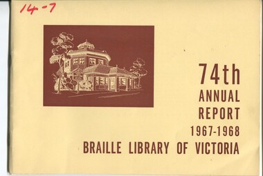 Vision Australia
Administrative record - Text, 74th Annual Report 1967 - 1968 Braille Library of Victoria, 1968
Articles include the death of R. Bigwood, a committee member for 40 years and former Vice President, Sir Rohan Delacombe (Patron) launched the library's first Open Day, large print and Moon books are becoming more in demand, four Tellatouch machines have been ordered, a sample tape recorder has been received from England, an electric Braille typewriter has been acquired, Mrs Weir has left the flat but Mr and Mrs Hood are now keeping an eye on the garden and building, Perkins Braillers are in high demand, a new auxiliary has been established in Altona, and Christmas card sales were higher than previous.32 pages of text with drawingsbraille library of victoria, corporation records -
 Marysville & District Historical Society
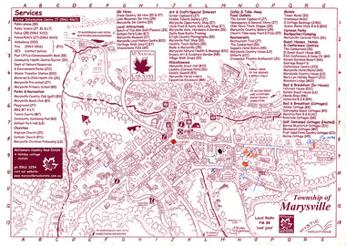
Map (Item) - Information map, Michael Hampton, 2000
An information map of the township of Marysville. This map was produced by McNamara Country Real Estate in 2000. The artist who drew the map was named Michael Hampton.An information map of the township of Marysville.MICHAEL HAMPTON/ 2000 VERSION 1:2/ 01/01marysville, victoria, australia, tourist map, information map, mcnamara country real estate, michael hampton -
 Vision Australia
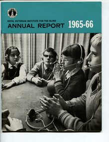
Administrative record - Text, Royal Victorian Institute for the Blind annual report 1965-1966, 1966
Overview of events that occurred in 1965-6 : celebration of the 100th year since establishment, development of a language laboratory, 600 talking book readers now use the library, discontinuation of millet broom making and focus on mat making, brush making and packaging and assembly work.1 volume of text and illustrationsannual reports, royal victorian institute for the blind -
Kew Historical Society Inc
Journal, Kewriosity : February 1990
Theatre group changes track [Track Players] / p1. Rates reminder / p1. People's Day / p2. Dates for February / p2. Children's Services Committee to re-convene / p2. Recycle your children's toys / p2. Senior Citizens' Week / p2. Cash-a-can centre for Kew / p2. Kindergarten places [Davis Street Kindergarten] / p2. Trill with the Phil [Kew Philharmonic Society] / p2. Commentary /Cr Michael Montalto p3. Council sets community reps [ Kew Recreation Centre] / p3. Due you have a hearing problem? / p3. Bluestone sales / p3. Council meetings resume / p3. CEO takes up the reins [Malcolm Hutchinson] / p3. Bushwalking provides photographic opportunities / p4. Notices / p4. Council building works complete [Civic Offices] / p4. Promise of brightest festival yet / p5. Meetings reminder / p5. Christmas gifts for HKC / p5. Spare room? Need help? / p5. Opposition leaders' new move / p5. Keri provides support for all / p5. Kew Community House / p6. War on waste slowed / p6. Council appeals for co-operation on rubbish days / p6. Traffic management update / p6. Historic bridge restored [Kane's Bridge] / p6. Time up for Kew Community House co-ordinator [Judy Price] / p7. Heritage advice / p7. Caption videos for the deaf / p7. Physiotherapy for children / p7. Memorial Walk [People Against Drink Driving, PADD] / p7. Footy news [Kew Football Club] / p8. Neighbourhood Watch / p8. Something for all at Seniors Centre / p8. Keeping you informed [Citizen's Advice Bureau] / p8. Rotarians entertain older citizens / p8.Kewriosity was a local newsletter combining Kew Council and community news. It was published between November 1983 and June 1994, replacing an earlier Kewriosity [broad] Sheet (1979-84). In producing Kewriosity, Council aimed to provide a range of interesting and informative articles covering its deliberations and decision making, together with items of general interest and importance to the Kew community and information not generally available through daily media outlets.non-fictionTheatre group changes track [Track Players] / p1. Rates reminder / p1. People's Day / p2. Dates for February / p2. Children's Services Committee to re-convene / p2. Recycle your children's toys / p2. Senior Citizens' Week / p2. Cash-a-can centre for Kew / p2. Kindergarten places [Davis Street Kindergarten] / p2. Trill with the Phil [Kew Philharmonic Society] / p2. Commentary /Cr Michael Montalto p3. Council sets community reps [ Kew Recreation Centre] / p3. Due you have a hearing problem? / p3. Bluestone sales / p3. Council meetings resume / p3. CEO takes up the reins [Malcolm Hutchinson] / p3. Bushwalking provides photographic opportunities / p4. Notices / p4. Council building works complete [Civic Offices] / p4. Promise of brightest festival yet / p5. Meetings reminder / p5. Christmas gifts for HKC / p5. Spare room? Need help? / p5. Opposition leaders' new move / p5. Keri provides support for all / p5. Kew Community House / p6. War on waste slowed / p6. Council appeals for co-operation on rubbish days / p6. Traffic management update / p6. Historic bridge restored [Kane's Bridge] / p6. Time up for Kew Community House co-ordinator [Judy Price] / p7. Heritage advice / p7. Caption videos for the deaf / p7. Physiotherapy for children / p7. Memorial Walk [People Against Drink Driving, PADD] / p7. Footy news [Kew Football Club] / p8. Neighbourhood Watch / p8. Something for all at Seniors Centre / p8. Keeping you informed [Citizen's Advice Bureau] / p8. Rotarians entertain older citizens / p8. publications -- city of kew (vic.), kewriosity, council newsletters, community newsletters -
 Wodonga & District Historical Society Inc
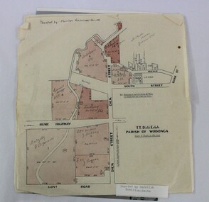
Map - Hamilton-Smith Collection Subdivision Map of Wodonga
The Hamilton-Smith collection was donated by the children of Grace Mary Hamilton-Smith nee Ellwood (1911-2004) and John Hamilton-Smith (1909-1984) who settled in Wodonga in the 1940s. The Ellwood family had lived in north-east Victoria since the late 1800s. Grace’s mother, Rosina Ellwood nee Smale, was the first teacher at Baranduda in 1888, and a foundation member of the C.W.A. Rosina and her husband Mark retired to Wodonga in 1934. Grace and John married at St. David’s Church, Albury in 1941. John was a grazier, and actively involved in Agricultural Societies. The collection contains significant items which reflect the local history of Wodonga, including handmade needlework, books, photographs, a wedding dress, maps, and material relating to the world wars. This item has well documented provenance and a known owner. It forms part of a significant and representative historical collection which reflects the local history of Wodonga. It contributes to our understanding of social and family life in early twentieth century Wodonga, as well as providing interpretative capacity for themes including local history and social history. A printed map of a Wodonga subdivision with hand written annotations On top proper right corner: "Donated by Merrilyn Hamilton-Smith". map, subdivision, wodonga, local history, maps, hamilton-smith, hamilton-smith collection -
University of Melbourne, Burnley Campus Archives
Plan, Kate Blood, City of Werribee Proposal for a Monument to Mark the Proclamation of Werribee as a City, 1987
Coloured elevation by Kate Blood dated 16.04.1987kate blood, werribee -
 Ballarat Tramway Museum
Administrative record - Memorandum, State Electricity Commission of Victoria (SECV), "Farewell function - Tramway Employees", 16/06/1971 12:00:00 AM
Yields information about the arrangements at 16 June for a farewell functions that was planned for the employees leaving the SEC at the time of the tramway closure., Yields information about the arrangements at 16 June for a farewell functions that was planned for the employees leaving the SEC at the time of the tramway closure.Photocopy on heat sensitive paper of a memo to employees "Farewell function - Tramway Employees", dated 16 June 1971, outlining the arrangements for a farewell function for the 83 employees leaving the SEC. Gives the invite list, but no date as yet, depending on the final closure dates. Has "Works Superintendent and Tram Depot foreman" typed in red in top left hand corner.trams, tramways, closure, ballarat, sec, depot, functions -
 Merbein District Historical Society
Administrative record - Accounts Book
Blue cover with red leather damaged spine with handwritten accounts bookMerbein Tennis Club Accounts Book 1935tennis, sports, merbein, accounts -
Bendigo Historical Society Inc.
Map - SANDHURST SHEET 2, 14/03/1923 ?
Map: Sandhurst sheet 2. Parish planmap, bendigo, parish plan, sandhurst -
Whitehorse Historical Society Inc.
Map, Ringwood, c1922
Victoria Ringwood Survey map 1 inch to 1 mile.Victoria Ringwood Survey map 1 inch to 1 mile. Covers Eastern suburbs of Melbourne from Richmond to Macclesfield, Heidelberg / Lilydale to Dandenong. Prepared by Commonwealth Section, Imperial General Staff.Victoria Ringwood Survey map 1 inch to 1 mile. eastern suburbs, melbourne, maps -
 Vision Australia
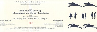
Administrative record - Text, Laura Clarke Auxiliary papers, 1972-2001
The Laura Clarke Auxiliary formed at the Mirridong Home in 1968 and was wound up on November 22, 2001. This collection of papers includes the minute books from 1972 to 2001 and a list of members was maintained at the front of the minute books as well as two individual lists have been retained.4 minute books --- 2 statement of accounts books --- 3 treasurers books --- 2 members lists (1998, 1999) --- notes for the Turkey and Champagne luncheon --- 1 stamp --- 4 receipt books --- 2 Champagne and Turkey Luncheon ticketsassociation for the blind, mirridong home (bendigo) -
 Bendigo Historical Society Inc.
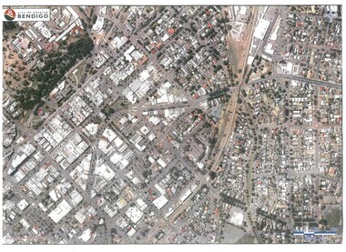
Map - BENDIGO MAP AERIAL VIEW
Map of Bendigo. Aerial View of Bendigo. Published by City of Bendigo. Undated.photograph, aerial, bendigo -
 Greensborough Historical Society
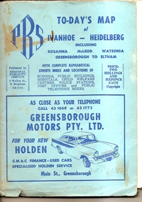
Map, To-day's Map of Ivanhoe - Heidelberg; including Rosanna, McLeod, Watsonia, Greensborough to Eltham, 1937-1953
Map of the suburbs of Ivanhoe, Heidelberg, Rosanna, Macleod, Watsonia, Greensborough and Eltham. Dates to mid 1950s. An Advertiser on this map may be found in the Hurstbridge Advertiser Friday 17 December 1937, page 7: "Lyon Bros, of Eltham garage, suggest in their advertisement on the front page of this issue. that motorists should have their cars checked over by them before Christmas, so that any 5mall defects which might militate against the pleasure of the trip, might be remedied." As does "The Montsalvat Plant Farm" in The Age of Saturday 5 September 1953, page 48.Shows early streets and open space in these areas.Fold out map in pale blue cover. Cover dimensions: 21.5x15cm. Map is surrounded by advertising for local businesses.ivanhoe, maps, heidelberg, rosanna, macleod, watsonia, greensborough, eltham -
Moorabbin Air Museum
Plan (item) - Bristol Aeroplane 170 schematic drawings, Assembly of Detachable Panel
Bristol Aeroplane Company Ltd -
Clunes Museum
Administrative record - BOOK, RENEWALS OF GARDEN LICENCE 5/
RECEIPT BOOK - RENEWALS OF GARDEN LICENCE 5/- 1885 - 87 LICENCE TO ENTER CROWN LANDS NOT EXCEEDING IN AREA ONE ACRE AS SPECIFIED HEREUNDER, FOR PURPOSES OF GARDEN AND RESIDENCE.BLUE COVERERED BOOK CONTAINING . RENEWALS OF GARDEN LICENCE NOs 68121 TO 68140 FOR YEARS 1885 - 87local history, local government, council, licence, garden -
Glenelg Shire Council Cultural Collection
Plan - Ship Plan / Mould, n.d
Wooden pattern for mould for boat fittings. Solid cylinder, in two halves lengthwise, joined by brass dowels. Smaller diameter cylinders either end. Outside painted green, inner flat surface of each half, unpainted. -
 Mission to Seafarers Victoria
administrative record (item) - Register, W.H.C. Darvall, The Victorian Seamen's Mission/Statistical Register/Attendance Record & General Memoranda./W.H.C. Darvall/Honorary Secretary, 1895
This handwritten ledger lists all annual meetings by date and includes all those in attendance. There is also a register of elections and other committee information. Stuck in behind all this statistical data are flyers advertising functions and events at the Mission.This ledger outlines the people involved in decision making at the Victorian Seamen's Mission in the late 19th C , the forerunner to Mission to Seafarers and 10 years prior to amalgamation with the group led by Rev'd. Alfred Gurney-Goldsmith. The ledger includes meeting dates as well as flyers advertising events and functions at the venue.Stuck to front cover and handwritten in ink: "The Victorian Seamen's Mission/Statistical Register/Attendance Record & General Memoranda./W.H.C. Darvall/Honorary Secretarywilliam henry charles darvall (1830-1906), office bearers, mission to seafarers, mission to seamen, seamen's mission, victoria, administration, committee, ledger, annual meetings, statistics, functions, events, register, elections, attendance, 1895 -
Whitehorse Historical Society Inc.
Map, Boroondara, Nunawading, 1853
Map of section of Parishes of Boroondara and NunawadingMap of section of Parishes of Boroondara and Nunawading with allotments numbered and named. Note on verso: Boroondara and Nunawading c1853.Map of section of Parishes of Boroondara and Nunawading maps, parish of nunawading, parish of boroondara -
 Lorne Historical Society
Map, F W Niven Lithos, The Mountjoy Lorne Estate, 1889
In 1888 a company was formed to acquire and subdivide the land of the Mountjoy Brothers. The land totaled 197 acres and included Erskine House. The land colored red was that of the Mountjoys. The subdivision map was printed in 1889A paper map of the Mountjoy Estate Lorne , showing allotments, with their owners, and naming land use. It has four black and white line drawings , Erskine House, Mountain View’s, the Rapids, Erskine House sea view and Erskine Falls. The map is largely black and white with red and blue colouring. The map is mstuck to brown paper. lorne, subdivision map, erskine house, mountjoy brothers, -
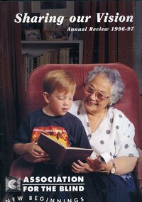 Vision Australia
Administrative record - Text, Sharing our vision: Association for the Blind annual review 1996/97, 1997
The annual report outlines the achievements of the year, financial position and client stories. Other articles outline centenary appeal, the redevelopment of Brighton, the introduction of CDs in the library service and expansion of the Community Aged Care Program.3 printed pages with illustrationsassociation for the blind, corporation records -
Warrnambool and District Historical Society Inc.
Administrative record - Ledger, 1878-1883
The person or business that used this ledger in Warrnambool is unknown. It contains accounts for sale of goods (one person per page) from 1878 to 1883.This ledger is of some interest because of the local 19th century Warrnambool names it contains but unfortunately the business name is unknown.This is a 19th century ledger of 888 pages. It has a hardboard cover that is tattered. It once had a red-coloured spine. The pages contain handwritten information in ink. warrnambool business ledger -
Port Melbourne Historical & Preservation Society
Plan - Immigration sculpture, Beacon Cove, Orchard Design Studio, Mark Weichart, 1998
Mirvac, Beacon Cove developers, commissioned this sculpture. Orchard contacted PMH&PS for 19th Century migrant ship names, to be handcarved into jarrah portion of sculpture, and for approval of 20th century ship names for the steel section. In return we requested a copy of these plans.Presentation plans (two sheets) for sculpture at Beacon Cove, designed by Orchard Design Studio of Pakenham. One in full colour, one a photocopy only. Subject: immigration.Photocopy signed by the artist, Mark Weichart.piers and wharves - station pier, immigration, transport - shipping, arts and entertainment - visual arts, mark weichart, orchard design studios, mirvac victoria, sculpture -
 Kew Historical Society Inc
Plan, Melbourne & Metropolitan Board of Works : Borough of Kew : Detail Plan No.1591, 1905
The Melbourne and Metropolitan Board of Works (MMBW) plans were produced from the 1890s to the 1950s. They were crucial to the design and development of Melbourne's sewerage and drainage system. The plans, at a scale of 40 feet to 1 inch (1:480), provide a detailed historical record of Melbourne streetscapes and environmental features. Each plan covers one or two street blocks (roughly six streets), showing details of buildings, including garden layouts and ownership boundaries, and features such as laneways, drains, bridges, parks, municipal boundaries and other prominent landmarks as they existed at the time each plan was produced. (Source: State Library of Victoria)This plan forms part of a large group of MMBW plans and maps that was donated to the Society by the Mr Poulter, City Engineer of the City of Kew in 1989. Within this collection, thirty-five hand-coloured plans, backed with linen, are of statewide significance as they include annotations that provide details of construction materials used in buildings in the first decade of the 20th century as well as additional information about land ownership and usage. The copies in the Public Record Office Victoria and the State Library of Victoria are monochrome versions which do not denote building materials so that the maps in this collection are invaluable and unique tools for researchers and heritage consultants. A number of the plans are not held in the collection of the State Library of Victoria so they have the additional attribute of rarity.Original survey plan, issued by the MMBW to a contractor with responsibility for constructing sewers in the area identified on the plan within the Borough of Kew. The plan was at some stage hand-coloured, possibly by the contractor, but more likely by officers working in the Engineering Department of the Borough and later Town, then City of Kew. The hand-coloured sections of buildings on the plan were used to denote masonry or brick constructions (pink), weatherboard constructions (yellow), and public buildings (grey). That area of Kew bordered by Cotham Road, Park Hill Road, Ermington Lane (now Ermington Place), and Belmont Avenue contained some of the significant homes owned by Kew pioneers. Chief among these was ‘Park Hill’ on an enormous lot facing Park Hill Road. The Jubilee History of 1910 noted, six years after this plan was drawn, that: ‘Park Hill Road, forming the southern boundary of the cemetery, takes its name from Park Hill, the residence of Mr. Thomas Judd, who has resided there since December, 1852.’ Other named houses on the plan include ‘Ferndale’ facing Cotham Road; ‘Ermington’ adjacent to Judd’s Park Hill, facing Park Hill Road; and ‘Gilden’ and ‘Mont Belmont’ facing Belmont Avenue. Mont Belmont was designed by the architectural firm of Reed, Henderson and Smart for William George Lilley in 1887 and was completed in 1888. Lilley was Mayor of Kew in 1887-88, a Justice of the Peace and a member of the first Board of Guardians of Kew’s St. Hilary’s Church of England.melbourne and metropolitan board of works, detail plans, survey plans - borough of kew, mmbw 1591, cartography