-
 Ringwood and District Historical Society
Administrative record - 2nd Ringwood Scout Group Recruitment Documents, Scout Association
Typed reports for 2nd Ringwood Scout Group Recruitment -
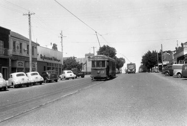 Ballarat Tramway Museum
Negative - Geelong 38 and welding truck - Moorabool St, early 1956
Photo shows Geelong 38 south bound to Belmont and welding truck - Moorabool St between Myers and McKillop Streets. The welding with the power supply from the overhead would most likely be repairing a broken joint. One of a set of photos was taken between 15/2/1956 and 3/3/1956 when services operated only between Belmont and North before the final closure of the Belmont route on 25/31956 and that bogie tram 31 is not shown on the board, having gone to Ballarat on 15/2/1956 - see item 5554. See item 8213 for an article on the Geelong system by Keith Kings. Yields information about the Geelong operations toward the closure of the tram system.Black and white Negative - 120 sizetramways, geelong, tram 38, moorabool st, welding truck, track repairs -
Stawell Historical Society Inc
Map, Township of Stawell Photo Map, 1947
Photograph of Stawell from Air Circa 1947. Shows mining sites and townshipmining, gold, map -
Moorabbin Air Museum
Manual (Item) - Bendix injection carburettors, Bendix Products Division Injector Carburettor Service Manual
Bendix Products Division -
 Bendigo Historical Society Inc.
Map - HUSTLER'S REEF MINE - EAST & WEST CROSS-CUTS, NORTH & SOUTH OF SHAFT
East & West Cross-cuts, North & South of Shaft, Hustler's Reef Mine Bulletin No 33, Plate No XIX. Map shows main shaft and smaller drawing of section with different stone encountered. Also gives location in relation to the shaft, e. g. 225'E & 150'S of Shaft. Reference diagram to show the different stone and features encountered. Geological Survey of Victoria emblem. Signed by H A Whitelaw, Underground Survey Office Bendigo, September 1913. This item has not been scanned or photographed.mining, parish map, hustler's reef mine, east & west cross-cuts north & south of shaft, geological survey of victoria, h a whitelaw, underground survey office bendigo -
Moorabbin Air Museum
Manual (Item) - Electronic Fundamentals (Part 1) Prepared By TIDS
TP-29 -
Bendigo Historical Society Inc.
Map - EPPALOCK, 3/11/1882
Map: Parish of Eppalock, County of Bendigo. Parish plan (number 327 in map cupboard 1)map, bendigo, parish plan, eppalock -
Moorabbin Air Museum
Plan (Item) - CAC Plans - Switches, Switch Plans
Commonwealth Aircraft Corporation -
Glenelg Shire Council Cultural Collection
Plan - Plans / Line Drawings - Port of Portland Authority, Victoria, 24/06/1972
PORT OF PORTLAND AUTHORITYFront: '48' - black texta, top right corner -
Moorabbin Air Museum
Manual (Item) - Cessna Models 310F 310G 310H 310I 310J 310K Parts Catalog
Description: Cessna Technical Level of Importance: . -
Moorabbin Air Museum
Manual (Item) - Boeing 767 Maintenance Manual
-
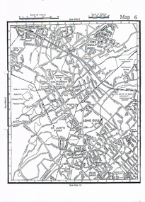 Bendigo Historical Society Inc.
Map - LONG GULLY HISTORY GROUP COLLECTION: MAP OF LONG GULLY
Copy of a street map showing Jobs Gully, California Gully, Long Gully, St Just's Point and Iron Bark.bendigo, history, long gully history group, the long gully history group - map of long gully, jobs gully, california gully, long gully, st just's point, iron bark -
Glenelg Shire Council Cultural Collection
Administrative record - Ledger - chemist, Chemist Ledger, 1914-1915
Sutton Chemist "Martell" Building, 79 Bentinck St, Portland.Front: Prescription Bookportland chemist, sutton, prescriptions, administrative record, ledger, 1914, wwi -
Moorabbin Air Museum
Manual (Item) - Journal of the Aeronautical Sciences Vol 4 No 2
-
Moorabbin Air Museum
Manual (Item) - Includes the G.A.F enaic analog computer and development costs, Government Aircraft Factories jet trainer project F2
-
Moorabbin Air Museum
Manual (item) - CAC CA-31 Design Directives incl. Photos
-
Lakes Entrance Regional Historical Society (operating as Lakes Entrance History Centre & Museum)
Administrative Record - Ledger, Poundkeepers Book, 20302
Entries are hand written in ink, pages 1 to 31 have been used, pages 31 to 97 are blank, Scale of Charges taped to inside cover, records across both page and facing page, 97 numbered leaves, leather bound with heavy cardboard coverA ledger containing details of animals impounded by Swan Reach pound during period December 1926 to 1955accounts book -
 National Vietnam Veterans Museum (NVVM)
Map, XA BINH BA (SE), 1967
Paper in map in strip form of Vietnam highlighting in red specific area of interest luscombe Field Nui Dat Overprint Information from RA SVY and Intelligence Sources Nov 67map, vietnam, ra svy -
Moorabbin Air Museum
Manual (Item) - Collins Avionics 331A-6D7 Course Indicator
-
 Lorne Historical Society
Map, F W Niven Lithos, The Mountjoy Lorne Estate, 1889
In 1888 a company was formed to acquire and subdivide the land of the Mountjoy Brothers. The land totaled 197 acres and included Erskine House. The land colored red was that of the Mountjoys. The subdivision map was printed in 1889A paper map of the Mountjoy Estate Lorne , showing allotments, with their owners, and naming land use. It has four black and white line drawings , Erskine House, Mountain View’s, the Rapids, Erskine House sea view and Erskine Falls. The map is largely black and white with red and blue colouring. The map is mstuck to brown paper. lorne, subdivision map, erskine house, mountjoy brothers, -
Moorabbin Air Museum
Manual (Item) - Ansett Boeing 737 Technical Manual Pitot static system, water & waste, Aux Power & Oxygen
-
Moorabbin Air Museum
Manual (item) - Mirage Retrofit program to upgrade aircraft life CAC
-
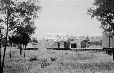 Eltham District Historical Society Inc
Negative - Photograph, Eltham Railway Station, c.1912
Viewed from the western side looking north east. A Tait rail car and Guard's van are parked at the platform.This photo forms part of a collection of photographs gathered by the Shire of Eltham for their centenary project book,"Pioneers and Painters: 100 years of the Shire of Eltham" by Alan Marshall (1971). The collection of over 500 images is held in partnership between Eltham District Historical Society and Yarra Plenty Regional Library (Eltham Library) and is now formally known as the 'The Shire of Eltham Pioneers Photograph Collection.' It is significant in being the first community sourced collection representing the places and people of the Shire's first one hundred years.Digital image 4 x 5 inch B&W Neg Print B&Wsepp, shire of eltham pioneers photograph collection, eltham, railway station -
Moorabbin Air Museum
Manual (Item) - RAAF Training Notes - Operation And Maintenance Of LDBO Storage And Transfer Tanks
-
Bendigo Historical Society Inc.
Map - GEOLOGICAL MAP BENDIGO GOLDFIELD, See above
Map: Geological map of the Bendigo Goldfield comprising 2 sheets , Numbered 9358a and 9358b. Prepared in 1923 re-issued in 1936map, bendigo, geological, geological map, bendigo goldfield -
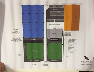 Kew Historical Society Inc
Plan, Kew Heights Sports Club Proposed Redevelopment 2012, 2012
Sports Clubs in Kew in the final decades of the 19th century and in the early 20th century were often umbrella organisations with facilities for a number of sports. Typically in Kew, this included teams in lawn bowls, tennis and croquet. The Kew Bowling Club was formed in 1880 while the privately owned Auburn Heights Recreation Club was opened in 1904. By 1998, the two Clubs decided to amalgamate at the Auburn Heights site in Barkers Road, forming the Kew Heights Sports Club. The combined club was itself taken over by the Melbourne Cricket Club in 2012 becoming MCC Kew Sports Club. In 2017 MCC Kew closed and its landholding was subsequently sold to Carey Baptist Grammar School. Both the Kew and Auburn Heights Clubs assembled important collections. These historically significant and large collections were donated to the Society in 2020. The collections include manuscripts, pictures, trophies, plans, honour boards etc. The combined collections of the four sporting clubs making up the collection number hundreds of items that are historically significant locally. They are also significant to the sporting history of the greater Melbourne area and to the sports of lawn bowls and tennis in Australia in the 19th and 20th centuries. The collection illuminates two of the Victorian historic themes - 'Building community life' through forming community organisations and 'Shaping cultural and creative life' by participating in sport and recreation.Architectural sketches on corflute of proposed designs for the new MCC Kew Sports Club by McIldowie Partners (Architects & Interior Designers), 2012.kew heights sports club - barkers road -- kew (vic.) -
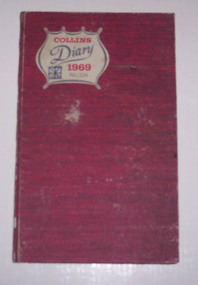 Ballarat Tramway Museum
Administrative record - Log book, Diary, Collins Bros, 1968
Yields information about the track maintenance activities of the track gang in Ballarat, the work they did, notes, names and other information.Collins Australian Diary, 1969, No. 324 printed by Collins Bros, dark red card covers, sewn sections with ruled sheets providing a diary for 1969, one week per double page. Has "useful information" sheets at from the diary. Used by the SEC Ballarat track gang to record their daily work, leave, welding, track cleaning, truck driver etc. Names of gang often mentioned in the diary undertaking specific jobs and when on leave. Loose contents 27/7/1969 - on the back of a Allocation of time sheet for E.C. Fish, a list of names and leave commencing and finish dates. Fish Clough Wiseman Vermeend Denbaden?tram, trams, sec, ballarat, depot, trackwork -
 Eltham District Historical Society Inc
Negative - Photograph, J.A. McDonald, Eltham-Yarra Glen Road, Lower Plenty footbridge, Sep. 1955
The Eltham-Yarra Glen Road as designated originated at the Shire of Eltham boundary at the Plenty River. West of the river the road was known as the Heidelberg-Eltham Road. The section from the Plenty River is now known as Lower Plenty Road which becomes Main Road. The footbridge no longer exists but was originally sited to the south, adjacent to the old Lower Plenty Bridge, now part of the Plenty River Trail. Record of various Shire of Eltham infrastructure works undertaken during the period of 1952-1962 involving bridge and road reconstruction projects, sometimes with Eltham Shire Council Project Reference numbers quoted. It was during this period that a number of significant improvements were made to roads and new bridges constructed within the shire that remain in place as of present day (2022). In many situations, the photos provide a tangible visible record of infrastructure that existed throughout the early days of the Shire. The album was put together by or under the direction of the Shire Engineer, J.A. McDonald.1955-09, eltham-yarra glen road, lower plenty footbridge, lower plenty, lower plenty bridge, lower plenty road, main road, plenty river trail, bridge construction, infrastructure, shire of eltham -
Moorabbin Air Museum
Manual (item) - RAAF Mirage Aircraft Equipment Development Sheets
-
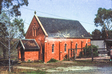 Eltham District Historical Society Inc
Negative - Photograph, Russell Yeoman, Kangaroo Ground Presbyterian Church, c.1980
View from front north side looking south west from cnr of Graham Road and Eltham-Yarra Glen RoadRoll of 35mm colour negative film, 2 strips Kodak Safety 5035 Colour print (x1)Kodak Safety 5035kangaroo ground, church, presbyterian church