-
 Bendigo Military Museum
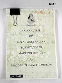
Administrative record - An analysis of Royal Australian Survey Corps mapping errors by Major LG Sam Thompson, Major LG Sam Thompson US Army Corps of Engineers at Army Survey Regiment, circa 1978
The purpose of the report is to analyze and study the map making procedures at the Army Survey Regiment to quantify the accuracy of the mapping to see if they meet acceptable accuracy standards. This was achieved through the study of possible errors.A4 loose leaf booklet held together with a "bulldog" paper clip. Cover part of an a RASvy 1:50,000 map. 1x Cover, 7x Introductory pages, 103x report pages.Marked on front cover "X - Box - 13", "TEXT 063"royal australian survey corps, rasvy, fortuna, army survey regiment, army svy regt, asr -
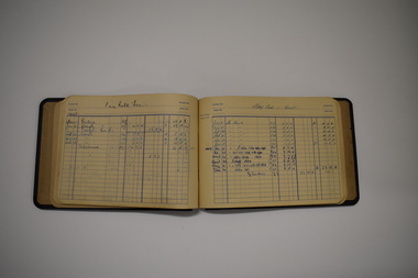
 Melbourne Tram Museum
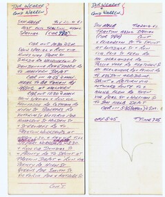
Administrative Record - Special Table, Melbourne & Metropolitan Tramways Board (MMTB), AETA Special using tram 980, Apr. 1962
Sprit duplicated onto MMTB table cards (cardboard printed on rear for driver / conductor timetable use), handwritten, table or timetable for a charter tram tour. Issued by the MMTB for a AETA Special using tram 980 on Tuesday 24-4-1962. Driver Wearne, Conductor Warren. Included a visit to Malvern, Preston, Preston, Essendon Airport, running in and out of South Melbourne depot. Timetabled for tram 980. Timetable on two sheets of cardboard, printed on blank side only.trams, tramways, aeta, special trams, charters, pcc, tram 980 -
 Stawell Historical Society Inc
Map, Fred W Wright Surveyor, Plan of the Borough of Stawell showing Mining leases & reefs 1870, 1870
Mining details. Including Tramways, Water Races. Crushing Mills. Reefs and Reserves.Copy of Original Showing Stawell Borough with details including mining leases Companies and MillsInsert with details of Sections 23, 34, 35 & 36. Fred W Wright 12 May 1870mining -
Ballarat Tramway Museum
Administrative record, T. Anderson Robertson and County Court, "Nankervis vs The Ballaarat Tramway Company Limited.", 1901
Copy of "Plaint Summons No. 39" lodged at the County Court, Ballarat May 1901, titled "Nankervis vs The Ballaarat Tramway Company Limited." Cost claimed was L100 (100 Pounds). Comprises: 1. Cover sheet, on pre printed form, filled out in light black ink and with pencil notations giving a sum of L28/9/6 and L30/0/0 (settlement figure?). Pinned with a brass clip to the cover sheet, which is in poor condition at edges is a handwritten sheet giving particulars of the demand and other details. 2. Copy of Interrogatories for the demands - three sheets of typed paper, pinned together to a typed cover sheet with a brass clip. Dated 15/4/1901 and signed by the W.E. Johnston, Deputy Judge. 3. Copy of handwritten statement by a person (a doctor?) who called on Mrs. Nankervis to assess her condition and circumstances - dated 28/3/1901. 4. Copy of handwritten letter from T. Anderson Robertson (Barrister and Solicitor) of Lydiard St. Ballarat, dated 27/2/1901 to the Chairman and Directors of the Ballarat Tramway Co. Ltd. advising them of the accident and seeking compensation. 5. Letter as for item 4, but dated 18/3/1901 detailing the accident and seeking L50. (50 pounds) settlement. - three separate sheets - handwritten letter. In the cataloguing sheet is an e-mail from Alan Bradley outlining how the documents were obtained. Care in handling paperwork required due to damage. trams, tramways, legal summons, horse trams, nankervis, accidents -
 Bendigo Historical Society Inc.
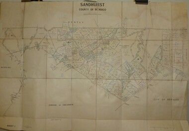
Map - JACK FLYNN COLLECTION: SANDHURST SHEET 1, January 1947
Map: Parish of Sandhurst sheet 1, County of Bendigo. Parish plan.map, bendigo, parish plan, sandhurst -
Moorabbin Air Museum
Administrative record (item) - RAAF Wirraway Aircraft Servicing And Maintenance Form E/E.77 Travel Copy - A20-369, Royal Australian Air Force, Travel Copy: Aeroplane Maintenance Form E/E. 77, 16/11/1954
Contains daily inspection and test flight records. Maintenance conducted at No 1 Basic Flight Training School, Uranquinty, New South Wales. -
University of Melbourne, Burnley Campus Archives
Administrative record, New Buildings File, 1983-1987
buildings, plant science laboratory, light framed lecture theatre, planting plan, vcah burnley, victorian college of agriculture and horticulture -
 Kew Historical Society Inc
Map, Osboldstone & Co Pty Ltd, Railway and Tramway Map of Melbourne and Suburbs With Tram Timetables, 1917
The Railway and Tramway Map of Melbourne and Suburbs With Tram Timetables lists existing Cable Tram Services before the entire network was electrified. By 1917 the tramways system was divided into regions including: the Melbourne Cable Tram Service; Prahran - Malvern Electric Trams; Hawthorn Electric Trams; Melbourne, Brunswick and Coburg Electric Trams; and Brighton Beach Electric Trams. The old Outer Circle railway line is marked as ending in Deepdene, with the remainder of the line to Fairfield marked as 'Unused'. The Kew tram along High Street in 1917 ended at the Harp Junction. The Kew Spur Line is also marked on the map.The Railway and Tramway Map of Melbourne and Suburbs With Tram Timetables is historically significant as it captures at a point in time, 1917, the development of public transport infrastructure in Melbourne. As such it illustrrates the theme: Connecting Victorians by transport and communications.Printed card-covered pocket sized map that folds out with three horizontal and vertical folds. Colour map, with scale, of the rail and tram networks on one side and sixteen sections of black and white printed text and timetable information on the reverse.railway maps -- melbourne (vic.), tramways maps -- melbourne (vic.), public transport -- melbourne (vic.) -- 1910-1920, cartography -
Whitehorse Historical Society Inc.
Map, Belgium and part of France map WW1, Nov 1917
WW1 map of Ypres and Menin. Sheet 28 Edition 3 Scale 1: 40,000 Nov 1917non-fictionWW1 map of Ypres and Menin. Sheet 28 Edition 3 Scale 1: 40,000 Nov 1917world war 1914 - 1918, world war 1914 - 1918 battle of ypres, maps -
Port Melbourne Historical & Preservation Society
Map - MMBW, c. 1894
Melbourne and Metropolitan Board of Works Plan No. 323,330, 335, 336 Segments shown: As Plan No. Large scale plan of lagoon fill area (40'=1")engineering - board of works, sandridge lagoon, transport - tramways, engineering - canals and drainage, built environment, gasworks, business and traders - hotels -
Whitehorse Historical Society Inc.
Map, State Electoral Districts, 1937
Map showing [Victorian] State Electoral Districts, Metropolitan, 1937.Map showing [Victorian] State Electoral Districts, Metropolitan, 1937. Scale: 40 chains to the inch.Map showing [Victorian] State Electoral Districts, Metropolitan, 1937.electoral boundaries, melbourne, elections -
 Ballarat Tramway Museum
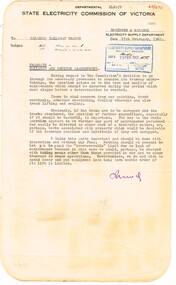
Administrative record - Memorandum, State Electricity Commission of Victoria (SECV), "Tramways - Ballarat and Bendigo Abandonment", 15/02/1962 12:00:00 AM
Yields information about the method of advising SEC staff about possibly reducing expenditure to a minimum., Yields information about the method of advising SEC staff about possibly reducing expenditure to a minimum.Memorandum to the Manager from the Engineer and Manager, dated 15/2/62, on departmental foolscap letterhead with rounded corners, titled "Tramways - Ballarat and Bendigo Abandonment". Notes the need to possibly curtail un-necessary expenditure, eg motor rewinding, pending the closure of the tramway, however discretion and caution is needed in the case of an accident.trams, tramways, maintenance, finances, sec, ballarat, bendigo, closure -
Bendigo Historical Society Inc.
Map - BOROUGH OF EAGLEHAWK RE-SURVEY, 6/06/1883
Map: Re-survey, Borough of Eaglhawk, Parishes of Nerring and Sandhurst, Sheet No. 1. Parish planmap, bendigo, re-survey, borough of eaglehawk, re-survey -
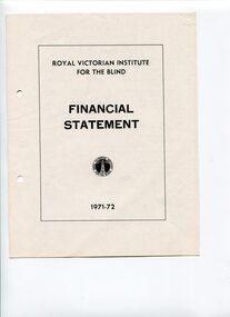 Vision Australia
Administrative record - Text, RVIB Financial Statement 1971-1972
Financial information for the Royal Victorian Institute for the Blind, presented as an appendix to the annual report of the institution.1 printed volume of financial information for the RVIBroyal victorian institute for the blind, annual reports -
 Bacchus Marsh & District Historical Society
Financial record, Weekly Account Book of William Grant's Bakery Business in Melbourne circa 1840s
William Grant was an early European colonist in the Bacchus Marsh township. Before arriving in Bacchus Marsh he conducted a bakery business in Melbourne in the 1840s. He arrived in Bacchus Marsh around 1850 and became successful in business and was prominent in many community and local government organisations. He died in 1884. Bound ledger book with hand written entries listing products and services provided by a bakery business conducted by William Grant in Melbourne. The entries cover the period 1842-1843.william grant 1813-1884, grant family bacchus marsh -
 Melbourne Tram Museum
Administrative record - Depot List, Public Transport Corporation (PTC), c1998
A4 photocopied sheet providing the location of tramcars at the various depots, includes Z and B class trams, Sydney R, Scrubbers, including Heritage cars stored at Hawthorn. Undated - 1998ctrams, tramways, tramcars, depot allocation, lists, depots -
Whitehorse Historical Society Inc.
Map, Nunawading, c1850
Early map of Nunawading, Bulleen and part of Boroondara areas.Early map of Nunawading, Bulleen and part of Boroondara areas.Early map of Nunawading, Bulleen and part of Boroondara areas.shire of nunawading, bulleen, boroondara -
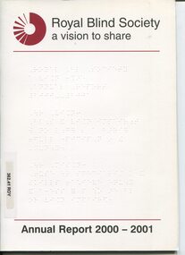 Vision Australia
Administrative record - Text, Royal Blind Society, a vision to share : Annual Report 2000-2001, 2001
Articles in the annual report include: launch of Vision Assist service to help people use their remaining sight, providing advice on Olympic and Paralympic accessibility and providing an audio description service to the associated arts festivals, establishment of VocalEyes Productions, became an RTO (Recognised Training Organisation), joining with RVIB library service, launch of JobPhone, and piloting of Braille Week.1 volume of text and imagesroyal blind society of new south wales, corporation records -
Glenelg Shire Council Cultural Collection
Administrative record - Ticket - souvenir of Edward Henty, 1934
Portland CentenaryPhoto of Edward Henty on cover in decorative edging. Pioneer Breakfast and Picnic. Sketch of Bronze wing pigeon. Poem. Golden Wattle tree - photo. Folds into 4 sections.Front: Souvenir Ticket 1934-1935 Centenary. Hand written on top - I trust that you will soon be well ?.S. -
Beechworth Cemetery Trust
Map - Beechworth Cemetery reproduction of original map - On site in Rotunda, Beechworth Cemetery
Reproduction map displaying all grave sites in Beechworth Public Cemetery. Rotunda, fountain, nursery, memorial wall, pioneer sectionmap displays the plan of grave sitesLaminated Photocopy of original cemetery map with additional information hand-written on the map. All graves at the cemetery set out in denominational sections with hand-written information on additional graves added to sections in Roman Catholic A & C, Church of England A-F, Presbyterian A-C, Methodist/Uniting B and Wesleyan A. Multidenominational hand-written note on Jews section with Trust Minutes 4.7.'83 written next to this addition. Additions hand-drawn of fountain, memorial wall, nursery and pioneer cemetery.rotunda, fountain, nursery, memorial wall, pioneer section, graves, chinese section, un-numbered grave sites, cemetery -
Glenelg Shire Council Cultural Collection
Administrative record - Supplementary Police Report of a Criminal Offence - 1913, 30/07/1913
Portland Police Station Records.Hand written supplementary Police Report of Criminal Offence - larceny of 2 books, Portland Police Station.Back: several hand written notes added 31/7 13 - 12 /8/13 -
Bendigo Historical Society Inc.
Map - NERRING. SHEET ?, Circa 1894
Map: Nerring, Part ( number unreadable), County of Bendigo. Parish plan ( number 190 in Map Cupboard 1)map, bendigo, parish plan, nerring -
Bendigo Historical Society Inc.
Map - SANDHURST : COUNTY OF BENDIGO, 12-7-27
Map. Sandhurst, County of Bendigo. Scale 20 chains to an inch. Huntly, Nerring, Marong, Mandurang, Strathfieldsaye, Wellsford, City of Bendigo. Photo-Lithographed at the Department of Lands and Survey, Melbourne by W.J. Butson12-7-27. Price 1/-. By authority H.J. Green, Govt. Printer. (number 33 in map cupboard 1)H.J. Green, Govt. Printer.map, bendigo, sandhurst -
Bendigo Historical Society Inc.
Map - SANDHURST SHEET 2, Date unreadable
Map: Sandhurst sheet 2. Parish planmap, bendigo, parish plan, sandhurst -
Glenelg Shire Council Cultural Collection
Administrative record - Quarterly Password - Ancient Order of Foresters, Aug-33
Printed piece of paper with Quarterly Password, from 1st Aug 1933 to 31st Oct 1933Front: 'Commence Centenary Celebrations' - hand written in pencil -
Bendigo Historical Society Inc.
Map - CAMPBELL COLLECTION: BENDIGO & DISTRICT MAPS, 5-4-28
Map. Sedgwick, Parishes of Strathfieldsaye, Lyell and Sedgwick. Scale 20 chains to 1 inch.Total area 5372 acres. Prepared in W.P.B. from C.l. and A. Plans by W.J. Galbraith. (number 374 in map cupboard 1)W.J.Galbraithmap, bendigo, agricultural lands -
 Warrnambool and District Historical Society Inc.
Administrative record - Ledger Containing Financial Records, 1940s
This ledger contains the financial records of a business that appears to be based in Warrnambool with connections to Koroit, Heywood and Dartmoor. The dates of the records are from 1941 to 1947. Unfortunately the name of the business is unknown but there are several references to the names, R.J. Allwood and G. Newnham.This ledger is of minor interest but if the business owner is confirmed in the future it will have some research value.This is a ledger with a black hard cover of composite material and metal binding. There is a metal mechanism in the back cover for inserting the pages. The pages have printed blue lines and blue print and handwritten entries in blue ink.warrnambool businesses 1940s -
Bendigo Historical Society Inc.
Map - CITY OF BENDIGO SHEET NO. 5, Circa 1890's
Map: City of Bendigo sheet No. 5. Parish plan ( number 213 in Map Cupboard 1)map, bendigo, parish plan, bendigo -
Bendigo Historical Society Inc.
Map - EAGLEHAWK (PART), 22/01/1882
Map: Parish plan showing area Eastward from Lightning Hill ( number 205 in Map Cupboard 1)map, bendigo, parish plan, eaglehawk, lightning hill -
Bendigo Historical Society Inc.
Map - CAMPBELL COLLECTION: BENDIGO AND DISTRICT MAPS, 30-1-29
Map. Ellesmere, Parish of Ellesmere, scale 20 chains to 1 inch. Total area 3926 acres. Prepared in W.P.B. from A. and P. Plans, by W.J. Galbraith, 30-1-29, to Bendigo along Fosterville. (number 381 in map cupboard 1)W.J.Galbraithmap, bendigo, agricultural lands