-
 Eltham District Historical Society Inc
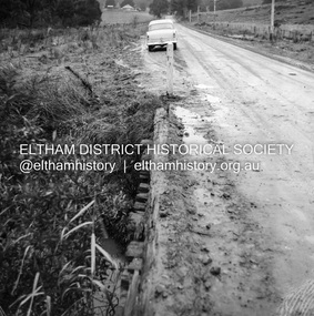
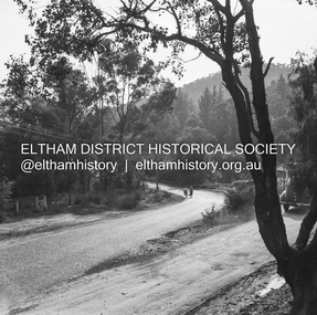
Negative - Photograph, J.A. McDonald, Healesville-Yarra Glen Road, c.1957
Bridge over Long GullyRecord of various Shire of Eltham infrastructure works undertaken during the period of 1952-1962 involving bridge and road reconstruction projects, sometimes with Eltham Shire Council Project Reference numbers quoted. It was during this period that a number of significant improvements were made to roads and new bridges constructed within the shire that remain in place as of present day (2022). In many situations, the photos provide a tangible visible record of infrastructure that existed throughout the early days of the Shire. The album was put together by or under the direction of the Shire Engineer, J.A. McDonald.infrastructure, shire of eltham, bridge construction, healesville-yarra glen road, 1957, long gully, healesville, long gully creek, old healesville road, jackson & dethridge, new zealand insurance co. ltd., public risk claim -
 Moorabbin Air Museum
Negative (Item) - Bristol Aircraft Company Drawings
-
Moorabbin Air Museum
Plan (item) - Bristol Aeroplane 170 schematic drawings, Assembly of Detachable Panel
Bristol Aeroplane Company Ltd -
Bendigo Historical Society Inc.
Negative - LA TROBE UNIVERSITY BENDIGO COLLECTION: BENDIGO TEACHERS' COLLEGE PHOTOGRAPHIC NEGATIVES
A collection of negatives of photographs collected by Ms. J.C. Burnett in preparation for her book titled 'History of Bendigo Teachers' College, 1926-1973.' This book was published by Cambridge Press in 1973. Note: (These negatives have not been scanned).bendigo, education, negatives, la trobe university bendigo collection, collection, bendigo teachers' college, education, bendigo, tertiary education, teacher training, ms. j.c. burnett, history of bendigo teachers' college 1926-1973, negative, negatives, photo, photograph, photographs, photography, proof, history -
 Vision Australia
Administrative record - Text, Association of Victorian Blind Workers Committee: 7/6/1931 - 25/1/1940, 1931-1940
These minutes include Present, Apologies, Correspondence, Registrations, Reports and Interviews with workers. 16/12/1938 it was noted the Secretary created a brochure called 'Social Justice for the Blind' and other publications for promotion of the organisation. It was also reported re the Institutions decision to pay Christmas pay on the basis of Married pensioners, £3-7-6, Married non-pensioners £4-7-6 per week and single men £2-2-6 per week. The child allowance has been discontinued. Meetings were often held in private homes or in spaces provided by churches.1 volume of handwritten notesassociation of victorian blind workers, royal victorian institute for the blind -
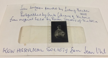 Kew Historical Society Inc
Negative, Ludwig Becker, John Hodgson, 1983
Donation includes a letter, dated 12 June 1983 from June Uhl to Mrs [Thea] Sartori referring to research about John Hodgson and the naming of Studley Park.Photographic negative of a lithograph of the Melbourne and Studley Park pioneer John Hodgson, accompanied by a letter from the donor, Jean Uhl.Envelope: "John Hodgson painted* by Ludwig Becker 1855. Photographed by State Library of Victoria from original held by Royal Historical Society of Victoria. Kew Historical Society from Jean Uhl." Editor note: Incorrect attribution. The Becker oil painting is held in the City Collection, City of Melbourne. This negative is of a lithograph based on a drawing of Hodgson, made by L. Becker circa 1855.john hodgson, studley park, stoodley pike - scotland, rev alex davies, jean uhl, ludwig becker -
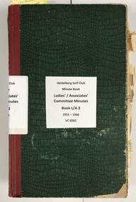 Heidelberg Golf Club
Administrative record - Minute Book, Heidelberg Golf Club, Ladies'/Associates' Committee Minutes: Book L/A 3: 1955-1960, 1955-1960
Handwritten and typed minutes of the Associates' Committee of Heidelberg Golf Club 1955-1960. Includes minutes of AGMs and general meetings with reports of activities and financial reports.Volume 3 of a complete set of Associates' minutes from the foundation of HGC to the present day.Cardboard bound minute book with green cover and dark red spine. Both handwritten and typed minutes pasted into book. Some inserted pages are in poor condition.Original label has dates "1955-1960" and "Book 35". Minute book labelled: "Conquest Account Book. Norman Bros."committee minutes, women's golf, associates, ladies' golf -
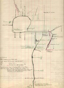
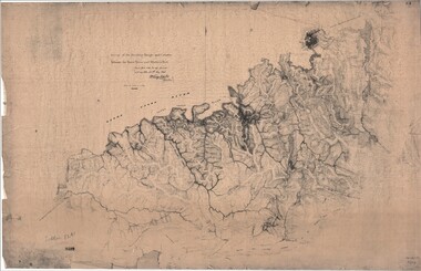 Ringwood and District Historical Society
Map, Survey of Dividing Range between Yarra Yarra and Western Port - William Wedge Darke, 1843
Extract - Ringwood, Place of Many Eagles - Hugh Anderson (1974): William Wedge Darke, from Hereford, England, was a nephew of John Helder Wedge of the Port Phillip Association, who was also a surveyor. William's most important work was probably his survey of the Dividing Range and the country between the Yarra River and Western Port, completed in May 1843, and during which he made a traverse between the Mullum and Dandenong creeks along the higher ground that he labelled the "best line of road from Melbourne". This road was for many years the major route to Gippsland and to the higher country about Alexandra and Mansfield, sometimes known as White Horse Road, and now Maroondah Highway.Surveyor's relief map of features to the east of Melbourne including Yarra Yarra River, Mullum Mullum Creek, Anderson's Creek, Dandenong Creek.Transmitted to the Surveyor General with my letter of 10th May 1843 (signed) Wm Wedge Drake, Assistant Surveyor. Scale: two inches to a mile. Descriptive remarks include upstream area of Yarra River - "impassable, appears to have been formerly a lake", and to the south - "barren and scrubby swamps of the Western Port Country". Marked tracks include "best line of road from Melbourne", "track to Dandenong", "Road to Port Albert may probably be found on this range", "Best line to Upper Yarra". Several huts also marked. -
 Ballan Shire Historical Society
Map - Map. Moorarbool East and West, Country Lands in the Parishes of Moorarbool East and Moorarbool West. Counties of Bourke and Grant
This is a map of "Country Lands" around the Werribee River, north of Ballan in the Counties of Bourke and Grant.A relatively small map, paper on a material backing. Shows topographical features, roads and property divisions. Scale of forty chains to one inch. The map is dated March 31st, 1859.There is a small inscription under the chain scale that reads "No 58/364 John Phillips ? Survey 1st August 1858". The name Dugald McPherson is hand written on one of the blocks of land.moorarbool west, moorarbool east, dugald mcpherson, county of bourke, county of grant, werribee river, ballan -
Federation University Historical Collection
Plan, Michael Adermann
A number of photos of Michael Adermannmichael adermann -
Bendigo Historical Society Inc.
Map - CAMPBELL COLLECTION: BENDIGO AND DISTRICT MAPS, 8-6 29
Map. Kimbolton, Parishes of Kimbolton and Lyell, scale 20 chains to 1 inch. Area by Plamimeter 6258 acres. Coliban River, Knowsley, Strathfieldsaye 10 1/2 miles. Prepared in W.P.B. from Parish and Assessor's Plans. G.W.Latimer 8-6-29. (number 393 in map cupboard 1)G.W.Latimermap, bendigo, allotments -
 Bendigo Historical Society Inc.
Administrative record - Abbott Collection: account books
Two index books listing the name of clients of Abbott Co. in alphabetical order. The names of individuals and companies are followed by various amounts. These accounts books don't have dates on.bendigo businesses, abbott, account book -
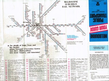
 Melbourne Tram Museum
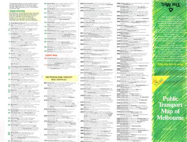
Map, The Met, "Public Transport Map of Melbourne" - "Effective August 1988", 1988
Map - Pocket size - folded - public transport map of Melbourne, printed in colour on art paper, showing public transport services in greater Melbourne, an index of localities. The City Saver area shown in detail. On the rear, route numbers, line maps of tram routes, train lines, outer metropolitan services, ticketing information, Transport Neighbourhoods, . Shows the St Kilda and Port Melbourne light rail lines. Price $2. Shows "The Met" logo. On front under The Met logo and above the scale bar is "Effective 1/7/1988".In ink in top left hand corner, "11" in a circle.trams, tramways, melbourne, map, routes -
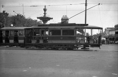
 Melbourne Tram Museum
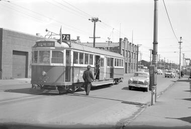
Negative, Travis Jeffrey, 1/12/1959 12:00:00 AM
Negative of tram 822 in Swan St Richmond, at Bendigo St. Tram has destination Wattle Park - Elgar Rd and Route No 70. Photo shows driver on road talking to conductor who is leaning out of doorway. Tram stop has a bundy clock. On the side of the bundy clock could be a point bar clipped to the clock case.Paper folder that contained the negative had "NR14A" written in red ink, "M14" written in pencil, "14A" written in blue ink, "P Ormond" written in purple ink and date stamped as 1 Dec 1959.trams, tramways, w5 class, swan st, crews, bundy clock, tram 822 -
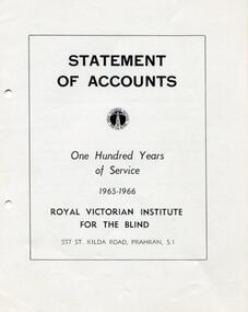 Vision Australia
Administrative record - Text, RVIB Statement of Accounts 1965-1966
Financial information for the Royal Victorian Institute for the Blind, presented as an appendix to the annual report of the institution.1 printed volume of financial information for the RVIBroyal victorian institute for the blind, annual reports -
 Ballarat Tramway Museum
Map, H.P. James, Ballarat tramway system, 1939
Hand drawn map contained within Reg. Item 2488, page 61 of the Ballarat Tramway system. Note does not show the Drummond St. North line. Shows the loops, horse tram loops, depots, ESCo bus routes, and notes on horse tram loops. Prepared by H.P. James Scan btm2515i2 and 2515i3 show the hand written notes in light pencil. Note Item Not formally Numbered.trams, tramways, map, depot, esco, horse trams, bus routes, ballarat -
Bendigo Historical Society Inc.
Negative - CASTLEMAINE GAS COMPANY COLLECTION: NEGATIVES
4 strips of negatives in plastic pockets. They were inside envelope 11518.479. These negatives have not been scanned.negative, bendigo, gas and fuel -
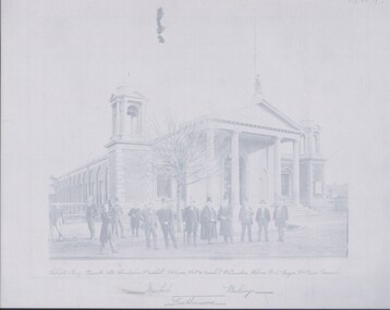 Bendigo Historical Society Inc.
Negative - TOM PATULLO COLLECTION: MARKET BUILDINGS
Negative print, Market Buildings. Castlemaine Councillors and others in front of the building, who are from left; Gibson, Tracy, Burnett, Slee, Christopher, Cr.Mitchell, Cr.Cooper, Cr. G.W.Greenhill, Cr.Dunstan, Holmes, Cr.McGregor, Cr.Pierce, Cornish.cottage, miners, market buildings., castlemaine-market buildings.-councillors -
Bendigo Historical Society Inc.
Map - SANDHURST (PART), Circa 1880's
Map: Parish plan showing Charleston Rd. Lloyd St. areamap, bendigo, parish plan, sandhurst, charleston road, lloyd street -
 Ballarat Tramway Museum
Negative, Wal Jack, Easter 1941, Saturday?
Negative and Digital images of the Wal Jack Bendigo Negative file of two trams at Charing Cross. Bendigo No. 22 is behind one of the ESCo trams, most likely Easter 1941 - see Reg Item 5757 for another Charing Cross photograph. Note the steps and barrier rails on the tram.trams, tramways, bendigo, easter fair, charing cross, esco, tram 22 -
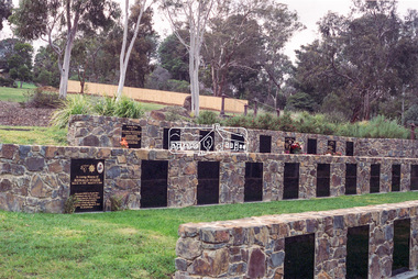 Eltham District Historical Society Inc
Negative - Photograph, Harry Gilham, Terrace Wall Section, Eltham Cemetery, Mount Pleasant Road, Eltham, 1 Aug 2007
Richard Gilsenan was a retired schoolteacher living at “Rosebank” in Eltham, now the site of the Living and Learning Centre. In 1906, Eltham Primary School’s headmaster John Brown died, and Richard was brought out of retirement (briefly) to be acting headmaster. His son Harold was a junior teacher there at the time. Thereafter, Richard was Secretary of the Eltham Progress League and more importantly was a magistrate at the Eltham Court of Petty Sessions. Cases commonly brought before him included not sending a child to school (typical fine 5/- or eight hours in the lock-up), not having a child vaccinated (fixed fine 40/-), stealing fruit from an orchard, selling liquor out of hours, and offensive language and behaviour. Other miscellaneous cases were allowing cattle to wander, selling cigarettes to a minor, carelessly burning off rubbish on a hot windy day, dumping a dead horse in the Diamond Creek, and youths throwing ripe fruit at passers-by. Richard died in 1920 and is buried in Eltham Cemetery with his wife Harriet Eliza. In mourning his passing, his peers noted that his decisions had been given in a very fair way. Incidentally, his son Harold (the teacher) died in 1921 after being trampled by a horse while en route from Eltham to Cathkin (his then school). In Loving Memory Of Richard Edward Gilsenan Died 30th July 1920 Aged 73 years Also Harriet Eliza Beloved wife of above Died 7th Sept. 1933 Aged 78 years Sweet Rest And In Loving Memory Of Barbara Ann Beloved wide of G. R. Gilsenan Died 18th Sept. 1917 Aged 38 years Also the above George Richard Gilsenan Died 2nd Nov. 1918 Aged 40 yearseltham cemetery, gravestones, memorials -
 Melbourne Tram Museum
Map, Ministry of Transport, "Melbourne Your guide public transport", 1980
Fold out map (27 sections 9 across x 3 deep), coloured of Melbourne's Tram and Bus routes, route numbers, rail lines, detailed for the central part of Melbourne and insert section for Frankston. On rear description of routes, private bus routes and map of Melbourne metro lines. Has contact details for bookings and lost property etc. Priced 30c No. 11 Dated 1980 on rear .1 - 1 as above, blue cover, No. 10, also dated 1980.trams, tramways, melbourne, map, tram & bus services, railways, mmtb, minister for transport -
Glenelg Shire Council Cultural Collection
Plan - Ship Plan / Mould, n.d
Wooden pattern for mould for boat fitting - cleat. Two elongated oval pieces of wood, one larger than the other, flat on one side, curving up from each end on the other. The two pieces joined together on sloping side, making a 'W' shape, either side. Painted yellow. -
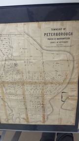 Peterborough History Group
Map - Map of the township of Peterborough, Township of Peterborough
Undated but indicative of the layout of the town. includes printed notes regarding the landscape and flora.Old map of the township of Peterborough from J S Irvine.A3 size paper map with tape around the sides. Includes handwritten notes.Handwritten on the rear is J.S Irvinepeterborough, old maps -
University of Melbourne, Burnley Campus Archives
Administrative record - Report, The University of Melbourne, Faculty of Land and Food Resources, The Burnley Master Plan, 2007
finance, buildings -
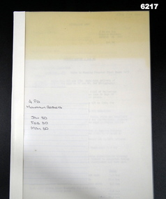 Bendigo Military Museum
Administrative record - 4 Fd Svy Sqn Monthly Report: Jan, Feb and May 1980, 31 May 1980
Monthly reports were mandatory for all RASvy unitsA plastic bound, A4 cardboard covered report that includes text and diagramsroyal australian survey corps, rasvy, fortuna, army survey regiment, army svy regt, asr -
Federation University Historical Collection
Map - Plan, Ballarat Deep Leads and Mines, 1992
This is Bulletin No. 62: Deep Lead Gold Deposits in Victoria. Map No.6 Ballarat Sheet 1 of 2 The map shows geology, topography and information on mines in the following areas: one large map of the Ballarat area with five enlargements for: Sago Hill District; Scarsdale District; Pitfield Plains District; Berringa Gold Field and Rokewood District. Ballarat Mines and Deep Leads Report No.94 (Finlay and Douglas,1992) provides a summary of the Geological Survey of Victoria mines database, references and geology for most of the mines on this map. Geology Compilation: simplified from earlier Departmental mapping with minor field checking by E.N.M. Plier-Malone. Very large rectangular sheet of paper with seven coloured maps of various sizes and a small green rectangle on the bottom rhs with a map of Victoria superimposed over a poppet head. this rectangle includes information of the other maps shown. The background for these maps is white. Also includes tables of names of mine companies, name of shafts and gold production.gold mines of australia, gold mines of victoria, gold mines- ballarat and district, gold mines pitfield plains district, gold mines scarsdale district, gold mines berringa gold field, gold mines rokewood district, gold mines sago hill district, map - gold mines, map - gold mines in victoria, ballarat, pitfield, scarsdale, berringa, rokewood, sago hill, deep lead gold deposits in victoria, geological survey - gold deposits in victoria, mining, gold deposits in victoria, gold mines in victoria, rokewook, pitfield plains -
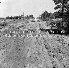
 Eltham District Historical Society Inc
Negative - Photograph, J.A. McDonald, Heidelberg-Kinglake Road, 11 May 1961
Silvan Road Bridge Looking northwards before reconstruction View centreline to left of old bridge site 11 May 1961Record of various Shire of Eltham infrastructure works undertaken during the period of 1952-1962 involving bridge and road reconstruction projects, sometimes with Eltham Shire Council Project Reference numbers quoted. It was during this period that a number of significant improvements were made to roads and new bridges constructed within the shire that remain in place as of present day (2022). In many situations, the photos provide a tangible visible record of infrastructure that existed throughout the early days of the Shire. The album was put together by or under the direction of the Shire Engineer, J.A. McDonald.1961-05-11, heidelberg-kinglake road, infrastructure, bridge construction, shire of eltham, reconstruction works, road construction, silvan road bridge -
Moorabbin Air Museum
Plan (item) - Bristol Aeroplane 170 schematic drawings, Front Replacement Tube Complete
Bristol Aeroplane Company Ltd -
 Eltham District Historical Society Inc
Negative - Photograph, J.A. McDonald, Eltham, Susan Street, Jan. 1961
January 1961 Looking towards Dalton Street (present-day Withers Way) Just south of Brougham Street. To the immediate left is the present-day car park for the Elham Leisure Centre. The house on the left is immediately opposite Cromwell street and adjacent to the southwest corner of the Leisure Centre buiding (where the Williams house sits hidden from view)Record of various Shire of Eltham infrastructure works undertaken during the period of 1952-1962 involving bridge and road reconstruction projects, sometimes with Eltham Shire Council Project Reference numbers quoted. It was during this period that a number of significant improvements were made to roads and new bridges constructed within the shire that remain in place as of present day (2022). In many situations, the photos provide a tangible visible record of infrastructure that existed throughout the early days of the Shire. The album was put together by or under the direction of the Shire Engineer, J.A. McDonald.shire of eltham, infrastructure, 1961-01, cromwell street, eltham leisure centre, road construction, susan street