-
 Ringwood and District Historical Society
Journal - Documents, Ringwood Croquet Club, Minutes of the Ringwood Croquet Club Committee meetings and Annual General meetings 1955-1960
The records of the Ringwood Croquet Club given to Gail Abbe - Archivist for safe - keeping with the request that they may be borrowed should the club require them for reference - 10-Dec-1993.Minutes of the Ringwood Croquet Club Committee meetings and Annual General meetings 1955-1960 -
 Ballarat Tramway Museum
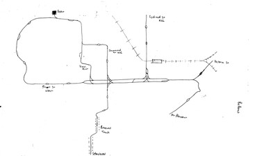
Map, Ballarat and Bendigo tram systems, 1960's or 1970's
Yields information about the extent of the Ballarat and Bendigo tramway systems and possibly has a strong association with the work of Tom Murray.Set of two hand drawn maps of the Ballarat and Bendigo tram systems, showing loops, terminus, depots and rail lines, including out of use loops and reserved track. Possibly made during the 1960's or early 1970's. Drawn on lined foolscap paper - have been torn from a pad.trams, tramways, map, drawings, ballarat, bendigo -
 Eltham District Historical Society Inc
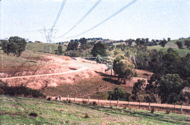
Negative - Photograph, Russell Yeoman, Maroondah Aqueduct, Kangaroo Ground, c.1980
Roll of 35mm colour negative film, 2 strips Colour print (x1)Kodak Safety 5035kangaroo ground, maroondah aqueduct -
 Bendigo Military Museum
Administrative record - DRIVERS LICENCE, ARMY, Australian Army, c1939-1945
Refer to 4967.2 Cat Small pocket size document - folds shut. Cover is brown buckram. Stamped on front is the Aust Coat of Arms, The words Australian Military Forces, Army Driving Licence. This is licence NR 85460. Army form AAF G11.V9520 Sgt Attwood John R. 4 Army troops RAE, Class 1 vehicles - 18 Dec 1941 (cars and vans).ww2, drivers licence -
 Melbourne Tram Museum
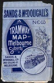
Map, Sands McDougall, "Tramway Map of Melbourne and Suburbs", c1906
Shows railways, cable and electric tram lines c1906. One of a number of maps produced by Sands McDougall of Collins St. Includes the MTOCo horse tram lines and the Caulfield horse tram lines. See items 2885 and 6573 for other editions. Yields information about Melbourne c1906 and its public transport lines. Map - folded sheet of paper 5 sections wide x 4 sections or folds deep contained within a light grey paper cover titled "Tramway Map of Melbourne and Suburbs"maps, melbourne, cable trams, tramways, railways, horse trams, nmetl, vr trams, sands mcdougall -
 Whitehorse Historical Society Inc.
Map, before 1890
Early map showing location and areas of plots and their owners' names between Heatherdale Road in the east and Springvale Road in the west, Burwood Road to the south to north of Canterbury Road. Later additions to 1969Early map showing location and areas of plots and their owners' names between Heatherdale Road in the east and Springvale Road in the west, Burwood Road to the south to north of Canterbury Road. Later additions to 1969Early map showing location and areas of plots and their owners' names between Heatherdale Road in the east and Springvale Road in the west, Burwood Road to the south to north of Canterbury Road. Later additions to 1969mitcham, vermont, nunawading -
Bendigo Historical Society Inc.
Map - MINING REPORTS - MAP OF COLLMANN AND TACCHI SHAFT
Hand drawn map showing the Collmann and Tacchi Shaft with No 17 Crosscut with the distances in feet and inches and the compass bearing of each leg. It is beside Mt Korong Road, near Dowding Street. Some boundary lines are drawn. Also on the map is Lansell's C and T across the road.map, bendigo, goldfields, mining reports, map of collmann and tachi shaft, collmann and tacchi shaft, lansell's c and t -
Whitehorse Historical Society Inc.
Map, Cadastral Map System, 2005
Land Victoria map of section of Blackburn North.Land Victoria map of section of Blackburn North, inc. Middleborough Road, Joseph Street and Chapman Street. Scale: 1:1500. With Lot Nos. and block frontage dimensions.Land Victoria map of section of Blackburn North. middleborough road, blackburn north, joseph street, blackburn north, chapman street, blackburn north -
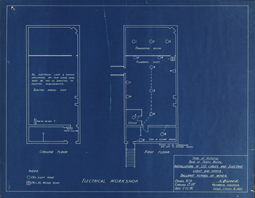 Federation University Historical Collection
Plan, Blueprint
-
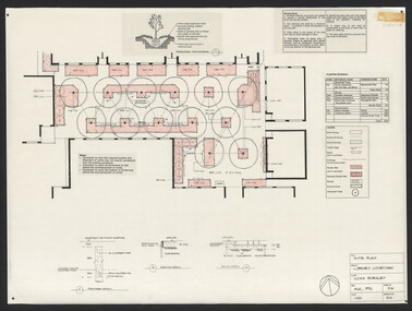 University of Melbourne, Burnley Campus Archives
Plan, Steve Mullany, Classroom Quadrangle/Library Courtyard, 1985-1999
Various plans. (1) Photocopy of Section A-A, 1985 and 1 photocopy of part of plan. (2) Tracing paper copy, Construction Plan Classroom/Library Quadrangle Feb. 1986. (3) Master Plan, coloured and detailed and 1 copy not detailed, Classroom Quadrangle Landscape Redevelopment by S. Mullany, 10 August 1988. (4) 4 tracing paper and 2 paper copies Set of Plans Library Courtyard Aug 1992 by KW. (5) Miscellaneous sketches. (6) Assessment task. (7) Sketch Proposal Quad Entry by M. Green May 1995. (8) Quadrangle Steps Redevelopment 7/12/99 by Phil Tulk. (9) Tracing paper and paper copies Quadrangle Steps Redevelopment by JK 20.12.99.classroom, library, courtyard, steve mullany -
Bialik College
Plan (item) - Proposed additions to Shakespeare Grove, 1970-1975
Architectural plans for proposed additions to Bialik Kindergarten, 6 Shakespeare Grove, Hawthorn, created by architects Joshua and Mary Pila, 1970-1975. Includes addition of assembly hall/gymnasium and classrooms (February 1972), kindergarten store and carpark roof (March 1975). Please contact [email protected] to request access to this record.1970s -
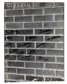 Robin Boyd Foundation
Journal, AIA Journal, Volume 149 No 894, Aug-71
This issue includes an article '100 years of Japanese Architecture: from Imitation to Originality' by Pierre Rambach, pp 37-40.architecture, walsh st library -
 Robin Boyd Foundation
Journal, Peter Bellew, Art in Australia, Series 4 No 5, Mar, Apr, May 1942
This volume features Glenunga Flats (1940) Armadale designed by architect Frederick Romberg, p 85.australian art, walsh st library -
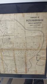 Peterborough History Group
Map - Map of the township of Peterborough, Township of Peterborough
Undated but indicative of the layout of the town. includes printed notes regarding the landscape and flora.Old map of the township of Peterborough from J S Irvine.A3 size paper map with tape around the sides. Includes handwritten notes.Handwritten on the rear is J.S Irvinepeterborough, old maps -
University of Melbourne, Burnley Campus Archives
Journal, Frank Read, Enriching Victoria's Rural Resources, 1960's
primary production, horticulture -
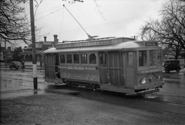
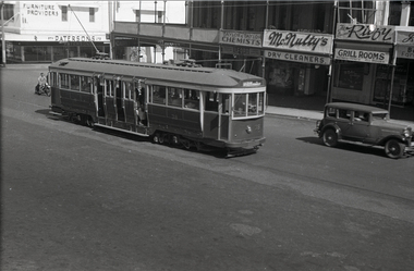 Ballarat Tramway Museum
Negative, Wal Jack, c1952
Yields information about the bogie tram No. 38 before its conversion to a one man format.Negative and Digital images of the Wal Jack Ballarat Negative file of No 38 prior to its conversion to a one-man-tram early in 1953 (See Reg Item 5551). In the background are Patersons Ltd,. Taylor & Taylor Chemist, McNulty's Dry Cleaners, The Ritzy Grill Rooms.trams, tramways, sturt st, one man trams, tram 38 -
University of Melbourne, Burnley Campus Archives
Plan (item) - Plans, New Chemical Store
Includes Internal Memoranda and Bore Log dated18.12.1989 -
Bendigo Historical Society Inc.
Map - STRATHFIELDSAYE, 25/06/1877
Map: Strathfieldsaye, County of Bendigo. Parish plan (number 291 in map cupboard 1)map, bendigo, parish plan, strathfieldsaye -
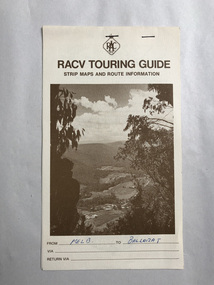 Robin Boyd Foundation
Map, RACV, Strip Maps Melbourne to Ballarat
walsh st library -
Moorabbin Air Museum
Administrative record (item) - CAC Administrative documents relating to the retirement of Secretary A G Brown, Mr. A. G. Brown Retirement as Secretary
Brown had been the Secretary of the CAC since its inception. -
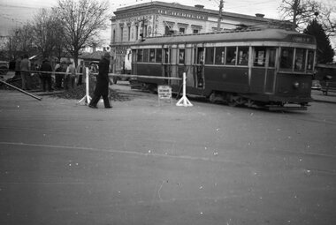 Ballarat Tramway Museum
Negative, Wal Jack, Jun. 1951
Yields information about the reconstruction of track at Hospital Corner and the way tram services were arranged and the corner itself.Negative and Digital image of the Wal Jack Ballarat Negative file of No. 35 crossing Sturt St while trackwork is being undertaken to replace diamond crossing at Hospital corner. The tram has the destination of Lydiard St North and is proceeding to Drummond St North to reverse. Based on Reg Item 5623, the work was done June 1951. In the background is H. E. Herbert's grocery shop, advertising "Rowland's" - soft drinks - see https://bih.federation.edu.au/index.php/Rowlands_Soft_Drink_Factory Reg Item 5079 - drawing of 6/1950 showing details of the crossing to be replaced. Reg Item 5340 - shows the building as well. Reg Item 5623 - has a note about the trackwork being undertaken on 19/6/1951. Reg Item 6225 - shows the new building being built during 1962. Reg Item 7720 - photocopy from Reg Item 5623 Reg Item 7721 - photocopy of the relevant page from the August 1951 issue of Electric Traction which details the event. trams, tramways, hospital corner, drummond st, sturt st, trackwork, tram 35 -
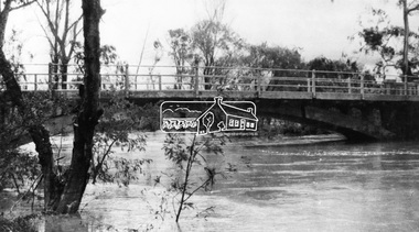 Eltham District Historical Society Inc
Negative - Photograph, Diamond Creek floodwater at Monash Bridge, Hurstbridge, Dec. 1934
The historic 1934 flood of the Diamond Creek and Yarra River following the storms of 29-30 November set the levels for future planning with respect to flood water rise.This photo forms part of a collection of photographs gathered by the Shire of Eltham for their centenary project book,"Pioneers and Painters: 100 years of the Shire of Eltham" by Alan Marshall (1971). The collection of over 500 images is held in partnership between Eltham District Historical Society and Yarra Plenty Regional Library (Eltham Library) and is now formally known as the 'The Shire of Eltham Pioneers Photograph Collection.' It is significant in being the first community sourced collection representing the places and people of the Shire's first one hundred years.Digital image 4 x 5 inch B&W Negshire of eltham pioneers photograph collection, hurstbridge, 1934 flood, floods, monash bridge, diamond creek (creek) -
 Ringwood and District Historical Society
Map, Department of Mines, Plan of area applied for under the mining leases regulations in the township of Ringwood between Maroondah Highway and Mt. Dandenong Road. Mining District of Castlemaine, County of Mornington, Parish of Ringwood T Area 58(A) 2 (R)15(P) Acres, Roods, Perches. 1934, 20-Feb-34
Map of the township of Ringwood with subdivisions between Maroondah Highway and Mt. Dandenong Road. the area applied for on lease No.8210 by E.G.Browne.Mining District of Castlemaine, County of Mornington, Parish of Ringwood T Area 58(A) 2 (R)15(P) Acres, Roods, Perches.Buff coloured sheet foolscap with black printing showing map of the township of Ringwood between Maroondah Highway and Mt. Dandenong Road. Mining District of Castlemaine, County of Mornington, Parish of Ringwood T Area 58(A) 2 (R)15(P) Acres, Roods, Perches +Additional Keywords: Browne E.G. -
 Ballarat Tramway Museum
Negative, Wal Jack, 1951
Yields information about the tram services and the Gold tram in Wendouree Parade.Negative and Digital image of the Wal Jack Ballarat Negative file of No. 23 as the gold tram in Wendouree Parade, Lake loop? trams, tramways, gold tram, wendouree parade, tram 23 -
Bendigo Historical Society Inc.
Plan - MARKS COLLECTION: FORTUNA PLANS
Copy of Plan: on top of plan 'Additions to Fortuna Villa for Geo Lansell Esq, scale 8 feet to one inch' Drawings of additions: ground plan, garden plan, second and third floor plan (mainly elevations).buildings, house, fortuna villa -
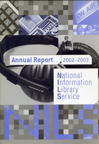 Vision Australia
Administrative record (item) - Text, NILS Annual Report 2002-2003
Second annual report for the National Information Library Service, which saw the joining of the Vision Australia Foundation library and alternative format production areas join NILS. This report shows the progress towards reducing duplication between state-based services, increasing the variety of Braille, audio and e-text materials and reducing costs, as well as the number of books, loans and materials produced over the year.national information library service, corporation records -
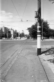 Ballarat Tramway Museum
Negative - Corner Drummond and Sturt Street tram stop, mid 1950s
Photo shows the inbound tram stop pole on the North west corner of Sturt and Drummond Streets Ballarat. Note the vertical "End Section" sign along with usual "End of Section" and "Cars stop here" sign at this compulsory tram stop. Another stop can be see on the other side of Drummond St along with No. 14 on its way to the City. Photographer unknown.Yields information about the tram stop at the corner of Sturt and Drummond St and signage.Black and white Negative - 120 sizetram stops, tramways, sturt st, drummond st, end of section sign, tram stop, sign -
Glenelg Shire Council Cultural Collection
Negative - Negative - Nelson, Victoria, c. 1936
Transparency for black and white photo. Panoramic view of Nelson, Vic, looking towards river mouth -
Bendigo Historical Society Inc.
Map - CAMPBELL COLLECTION: BENDIGO AND DISTRICT MAPS
Map. Sedgwick. Parishes of Strathfieldsaye, Lyell and Sedgwick. Scale 20 chains to 1 inch. (number 359 in map cupboard 1)map, bendigo, agricultural lands -
Glenelg Shire Council Cultural Collection
Administrative record - Ticket, n.d
Victorian Railways Condah to Portland second class ticket, blue heavy card, black print. No. 6066.Back: '06066' - stamp