-
 Warrnambool and District Historical Society Inc.
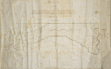
Map - Farnham Survey, 1850s
This is a map of the Farnham Special Survey. In 1843 William Rutledge purchased this Special Survey of 5,120 acres and named it Farnham. This Survey extended from Tower Hill to the Merri River at Dennington. The map appears to date from the 1850s This early map is of considerable significance as it shows details of the Farnham Special Survey. William Rutledge and his survey are important influences in the development of Warrnambool and district with the establishment of settlements at Killarney, Yangery and Tower Hill.A hand drawn map on waxed paper in brown, black and blue ink. It shows Armstrong's Bay, sea, Crown Land , the names of properties and some roads. It includes a compass direction diagram.farnham special survey -
 Lilydale RSL Sub Branch
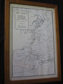
Map - Framed copy of map, The canadian and American Seaboard - January to July 1942
Framed copy of mapThe Canadian and American seaboard - January to July 1942. Shows Merchant ships sunk, U boats sunk and coastal convoys organised by July 1942. -
 Whitehorse Historical Society Inc.
Map, Aborigines of Bulleen, n.d
Map showing traces of Wurunngeri Tribe to be found in an area which became City of Doncaster and Templestowe, taken from history written by Irvine Green.Map showing traces of Wurunngeri Tribe to be found in an area which became City of Doncaster and Templestowe, taken from history written by Irvine Green.Map showing traces of Wurunngeri Tribe to be found in an area which became City of Doncaster and Templestowe, taken from history written by Irvine Green.aborigines, city of doncaster -
 Hymettus Cottage & Garden
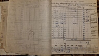
Administrative record - Time sheet carbon book, 1935
-
 Vision Australia
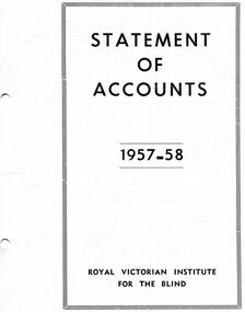
Administrative record - Text, RVIB Statement of Accounts 1957-1958
Financial information for the Royal Victorian Institute for the Blind, presented as an appendix to the annual report of the institution.1 printed volume of financial information for the RVIBroyal victorian institute for the blind, annual reports -
Glenelg Shire Council Cultural Collection
Administrative record - Heywood Consolidated School, Council Minute Book, c. 1951
From the collection of the Bower Bird Museum, Heywood.Heywood Consolidated School Advisory Council minute book July 1951 - September 1965. Heavy cardboard covers, dark green fabric, tan suede spine and cover corners. 'Minute Book' in gold lettering on red, on spine.administrative record, minutes -
 National Vietnam Veterans Museum (NVVM)
Literary Work, For the Vietnam Veterans - the least we can do!
Framed & with a chipboard base in black and white print of a poem: For the Vietnam Veterans - The Least We Can Do. Includes 20 versesG'Day, Well done and God bless you mate.poetry, veterans -
Stawell Historical Society Inc
Map, Crowlands & Navarre Railway Construction Trust, VR Plan Showing Railway Construction District Crowlands to navarre Line 1916, 4 July 1916
Two (2) Very large Coloured Maps. Scale 40 Chains to 1 Inch. rail Line Drawn in RedShire of Kara Kara. Shire of Stawell Shire of Ararat 4 July 1916railways -
 Vision Australia
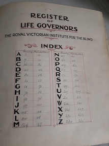
Administrative record - Text, Register of Life Governors, 1930s to 1950s
Handwritten list of Life Governorships awarded to various people from the RVIB during the 1930s until the 1950s. Entries include the name and address or township of recipients, and later a date column was included. No information is included on why a Life Governor was granted however this was usually in recognition for the funds donated to the institution. This amount was dependent upon the time of the contribution. In the Constitution and Rules section of the 1872 Asylum and School for the Blind Annual Report: Membership - Every Subscriber of 10s., and upwards per annum shall be a Member of the Institution, and every donor of 20 pounds and upwards, a Life Member. Auxiliary members who were appointed Life Governors were usually involved in helping organise some of the many fundraising activities, such as the Auxiliaries Annual Three Day Fair. A Life Governorship also meant that the person would have a vote when it came to some decisions made by the Committee of Management. RVIB Life Governors are listed cumulatively in the annual report until 1935 when, due to reasons of space, it was altered so that names appeared only in the year that they were granted. This continued until 1999/2000 when these were no longer awarded.Vinyl covered record book with alphabetical listing of some Life GovernorsR.V.I.B. Life Governersroyal victorian institute for the blind, fundraising -
 Ringwood and District Historical Society
Administrative record, Packet: Ringwood City Council Jubilee (50 Years) 1974, and City Film material, 1974
City Council Jubilee (50 years) 1974 re city film -
Stawell Historical Society Inc
Map, Special Surveys, District of Ararat, 1968
Special Surveys, District of Araratstawell -
 Vision Australia
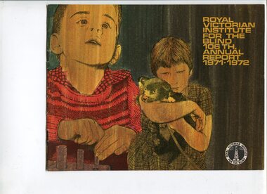
Administrative record - Text, Royal Victorian Institute for the Blind annual report 106th 1971-1972, 1970-1971
Articles in the annual report include: Matron Dunnell receiving a Churchill Fellowship, a second year wrap up of residential accommodation for children with multiple disabilities, replacing cassette players with newer models, employment of 120 people in the factory and 82 people received individualised training and rehabilitation programs.1 printed volume with photographsroyal victorian institute for the blind, annual reports -
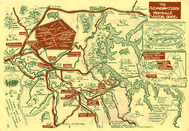 Marysville & District Historical Society
Map (Item) - Tourist map, The Alexandra and Eildon Standard, THE ALEXANDRA & EILDON MARYSVILLE VISITOR GUIDE, 1997
A tourist map for the Alexandra, Eildon and Marysville region that was produced by the Alexandra and Eildon Standard newspaper. This tourist map was produced in 1997.A tourist map for the Alexandra, Eildon and Marysville region that was produced by the Alexandra and Eildon Standard newspaper.c 1997/ PUBLISHED BY/ THE ALEXANDRA/ AND EILDON/ STANDARD./ GRAPHICS/ BY THE T.T.S./ EILDON.alexandra, eildon, marysville, victoria, australia, tourist map, alexandra & eildon standard -
 Ballarat Tramway Museum
Map, Electric Supply Co. of Vic (ESCo), Ballarat Electoral Map - ESCo, 1900
Document prepared by the Electric Supply Co of Victoria, as part of an order under the Electric Light and Power Act 1896, section 5 of order No. 17 granted to company. Dated 19/2/1901 and signed by the Postmaster-General. Shows the order area being parts of the City of Ballaarat, Sebastopol and Ballarat East. Shows the street names, boundaries, principal power line routes, land reserves, parks, mine locations, railways and Lake Wendouree. Signed by R L Williams Town Clerk City of Ballarat, J R Hall for the Borough of Sebastopol, and John Gent for the Town of Ballarat EastYields information about the power supply to the Ballarat area.Cloth backed paper map, coloured and marked up as exhibit 17.Notes in ink including the signature of Benjamin Deakin 24/9/00 and certified by the three involved municipal Town Clerks.ballarat power supply, esco, electric supply co of victoria, city of ballaarat, east ballarat, sebastopol, orders, power lines, power supply -
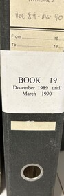 Heidelberg Golf Club
Administrative record - Reports, Heidelberg Golf Club, Directors' Reports: Book 19: December 1989 - March 1990, 1989 - 1990
Typed reports to Directors of Heidelberg Golf Club from the various sub committees: December 1989 - March 1990. There is some duplication of contents with Book 18 (VC0378).Volume 19 of a set of reports to Directors. Black arch file binder, multiple pages, unnumbered. committee reports, directors' reports -
Whitehorse Historical Society Inc.
Map, Blackburn and Nunawading Map, 1960's?
Map of Blackburn and Nunawading.Map of Blackburn and Nunawading.Map of Blackburn and Nunawading.maps, blackburn, nunawading -
Whitehorse Historical Society Inc.
Map, Shire of Boroondara, Parish of Nunawading, 1904
Photocopy of printed map extending from Camberwell to Middleborough Road.Photocopy of printed map extending from Camberwell to Middleborough Road. note on verso: From a book of maps dated 1904.Photocopy of printed map extending from Camberwell to Middleborough Road. maps, shire of boroondara, parish of nunawading -
Moorabbin Air Museum
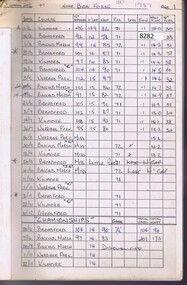
Map (Item) - Associated Area Terminal Charts - Various
-
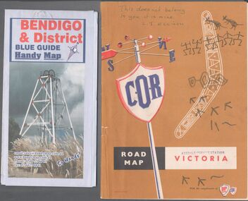 Bendigo Historical Society Inc.
Map - Road maps
Two road maps. On, Bendigo & District blue guide handy map the other a road map of Victoria. On the back of the Bendigo map the date October 2000. On the Victoria map the words in pen "This doesn't belong to you, it is mine". L.J. Ellison and a blue stamp of Axedale service station. Aileen and John Ellison Collection.road map, victoria, bendigo -
Ringwood and District Historical Society
Legal record - Conditions of Sale (C.E.Carter), Ringwood, Lot 33 on Plan of Subdivision 10917, Mr S.T.Reiher and Mrs S.J.Nichols, 1947
Particulars and Conditions of Sale of Property , from Mr S.T.Reiher to Mrs S.J.Nichols. -
 Vision Australia
Administrative record - Text, Royal Victorian Institute for the Blind annual report 1968-1969, 1968-1969
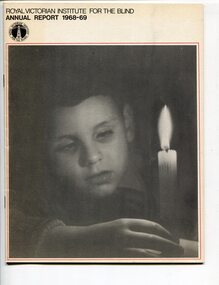
Activities in annual report include: beginning to plan for centre for multi-handicapped children, expansion of home care program for deaf/blind children, continued to provide secretariat for the Australian National Council for the Blind, past President Dr Charles Bennett was awarded an OBE in June 1969, teacher George Findlay awarded an MBE in June 1968, formation of a ski club which conducted a ski camp, continuance of interest-free home purchase loans for blind workers, death of Bert Merrick who led the Blind People's Social Club for many years and the creation of the Bert Merrick Memorial Picnic and two prizes for Burwood School children to honour him.1 volume of print and illustrationsannual reports, royal victorian institute for the blind -
Whitehorse Historical Society Inc.
Map, Map of East and South eastern suburbs of Melbourne, 1930s
Map of suburbs of Melbourne from Kew to Ringwood and South Morang Station to East Oakleigh.Map of suburbs of Melbourne from Kew to Ringwood and South Morang Station to East Oakleigh.Map of suburbs of Melbourne from Kew to Ringwood and South Morang Station to East Oakleigh.blackburn, mitcham, hawthorn, box hill, doncaster, templestowe -
 Ballarat Tramway Museum
Administrative record - Log book, Diary, Collins Bros, 1968
Yields information about the tramcar maintenance activities of the SEC at the depot in frequency of changing brake blocks, light bulbs, trolley rope and wheels for each tramcar.Collins Diary No. 324, 1968, red Rexene covers, sewn sections with ruled sheets providing a diary for 1969, 7 days and notes for each double page. Has "useful information" sheets at from the diary. Used by the SEC Ballarat depot to record brake block changes and light globe replacements on each tramcar. Also gives details on trolley rope and trolley wheel replacements.tram, trams, sec, ballarat, depot, brake blocks, trolley wheels -
Port Melbourne Historical & Preservation Society
Legal record - Contract, construction of Williamstown Short Road, Port Melbourne, 13 Nov 1896
Contract for the construction of Williamstown Short Road and part of Graham Streetengineering - roads streets lanes and footpaths, rumpt bros & ebeling, town of port melbourne, town of williamstown -
 Greensborough Historical Society
Administrative record - Record Book, Thomastown Golf Club et al, Thomastown Golf Club Handicap books - Committee Meetings 1987-1992, 1987-1992
Books used by Thomastown Golf Club to record members' handicaps 1987-1990 and 1992. Maintained by Robert (Bob) Jones, Golf Club Secretary.Thomastown Golf Club was a social club formed in 1976. This is part of the Robert (Bob) Jones collection of Club memorabilia.Bound pages in folders with clear plastic covers.Handwritten records.thomastown golf club, bob jones, golf handicaps -
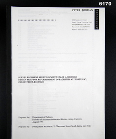 Bendigo Military Museum
Administrative record - Design Brief for Refurbishment of Facilities at "Fortuna Villa", Peter Jordan Architects, 55 Clements St, South Yarra, Vic 3141, 1994
Refurbishment Plans for building Works at Fortuna Villa, Building 23 (Ordinary Ranks Accommodation Barracks) were completed, Building 8 works were never commenced.Plastic Covered Book, A4 Pages, Building plansPeter Jordan Architects, 55 Clements St, South Yarra, Vic, 3141royal australian survey corps, rasvy, fortuna, army survey regiment, army svy regt, asr -
 Montmorency/Eltham RSL Sub Branch
Map - Framed 1915 map of Sulva Bay, Gallipoli, 1915 Map of Silva Bay, Gallipoli, 1915
This map was used in the Dardenelles Campaign 1915-1916.Framed map showing the Sulva Bay area of the Gallipoli battlefield in 1915.world war one, middle east, gallipoli, 1915, map, dardenelles, sulva bay, survey department, battlefields, egypt cairo -
Whitehorse Historical Society Inc.
Legal record - Land Title, Deep Creek Road, Mitcham, 1936
Certificate of Title vol 6087 Fol 1217316 Lot 133 of plan of subdivision no 8022 in the name of Francisco Schwerkolt on 22 Dec 1936 including transactions until Oct 2000.Certificate of Title vol 6087 Fol 1217316 Lot 133 of plan of subdivision no 8022 in the name of Francisco Schwerkolt on 22 Dec 1936 including transactions until Oct 2000.Certificate of Title vol 6087 Fol 1217316 Lot 133 of plan of subdivision no 8022 in the name of Francisco Schwerkolt on 22 Dec 1936 including transactions until Oct 2000.schwerkolt, francisco, deep creek road, mitcham, no 27., rangeview grove, hogan, frances dora, collins, douglas alexander, oulton alice, vicic, susan manuella, hammond, wayne, alexander, hannelore -
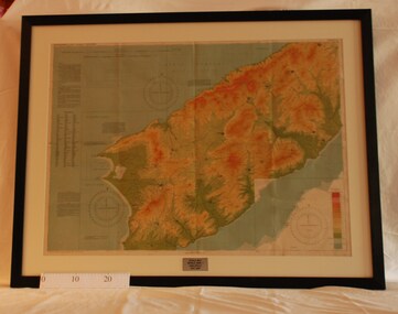
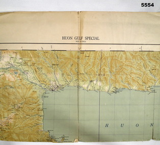 Bendigo Military Museum
Map - MAP, HUON GULF AREA, Aust Survey Corps et al, Aug 43
Refer Cat 5547 - Matheson.This is a single sided map, printed in colour. Scale 1:253,440, 4 miles to an inch, grid squares are 10mm x 10mm. Top right side shows Finschafen. Top centre is Lae, Middle is Salamau. Bottom is Lasanga Island. Top left vicinity is Nadzab and Markham River.There are four "corner" marks in pencil. Two on land and two out in the gulf.ww2, new guinea, map -
Clunes Museum
Map, F.W. NIVEN 34 STURT ST. BALLARAT & EMBOSSER
SCROLL - SURVEVOR MAP AND PLAN OF NEW CRESWICK GOLD FIELDS SURFACE LEVELSlocal history, document, maps, mining - maps